Showing 127 items matching "excavating"
-
 Federation University Historical Collection
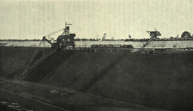
Photograph - black and white, State Electricity Commission, Excavating Brown Coal at open-cut, Yallourn
... Excavating Brown Coal at open-cut, Yallourn......excavating...Barker Library (top floor) Mount Helen goldfields Photograph included in book "Victoria: Gold and Minerals" issued by Mines Department Victoria, 1935 victoria excavating dredge brown coal yallourn Photograph Excavating Brown Coal at open-cut, Yallourn Photograph - black and white State Electricity Commission ...Photograph included in book "Victoria: Gold and Minerals" issued by Mines Department Victoria, 1935Photographvictoria, excavating, dredge, brown coal, yallourn -
 Eltham District Historical Society Inc
Photograph, Excavating Railway Cutting to Hurstbridge
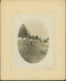
... Excavating Railway Cutting to Hurstbridge...Labourers excavate a cutting for the new railiway extension from Eltham to Hurstbridge. ...Eltham District Historical Society Inc 728 Main Rd Eltham melbourne Labourers excavate a cutting for the new railiway extension from Eltham to Hurstbridge. ...Labourers excavate a cutting for the new railiway extension from Eltham to Hurstbridge. Men are working with shovels and buckets, dropping dirt into horse and carts. A pile of newly cut sleepers sit on the sidelines waiting to be laid. The new extension is approx. seven miles in length and opened on 2 January, 1912.This photo forms part of a collection of photographs gathered by the Shire of Eltham for their centenary project book, "Pioneers and Painters: 100 years of the Shire of Eltham" by Alan Marshall (1971). The collection of over 500 images is held in partnership between Eltham District Historical Society and Yarra Plenty Regional Library (Eltham Library) and is now formally known as 'The Shire of Eltham Pioneers Photograph Collection.' It is significant in being the first community sourced collection representing the places and people of the Shire's first one hundred years.Digital imagesepp, shire of eltham pioneers photograph collection, diamond creek, hurstbridge, wattle glen, railway line construction, railroad construction workers, railroad construction -
 Eltham District Historical Society Inc
Photograph, Fred Mitchell, Excavating at the corner of Main Road and Bridge Street, Eltham, 1968, 1968
... Excavating at the corner of Main Road and Bridge Street, Eltham, 1968...Eltham District Historical Society Inc 728 Main Rd Eltham melbourne Roadworks for duplication of Main Road. fred mitchell collection 1968 eltham bridge street Main Road Road construction duplication Digital copy of colour photograph Excavating at the corner of Main Road and Bridge Street, Eltham, 1968 Photograph Fred Mitchell ...Roadworks for duplication of Main Road.Digital copy of colour photographfred mitchell collection, 1968, eltham, bridge street, main road, road construction, duplication -
 Eltham District Historical Society Inc
Photograph, Fred Mitchell, Excavating at the corner of Main Road and Bridge Street, Eltham, 1968, 1968
... Excavating at the corner of Main Road and Bridge Street, Eltham, 1968...Eltham District Historical Society Inc 728 Main Rd Eltham melbourne Roadworks for duplication of Main Road. fred mitchell collection 1968 eltham bridge street main road road construction duplication Digital copy of colour photograph Excavating at the corner of Main Road and Bridge Street, Eltham, 1968 Photograph Fred Mitchell ...Roadworks for duplication of Main Road.Digital copy of colour photographfred mitchell collection, 1968, eltham, bridge street, main road, road construction, duplication -
 Inverloch Historical Society
000841 - Photograph - Excavating reservoir
... 000841 - Photograph - Excavating reservoir...Inverloch gippsland 000841 - Photograph - Excavating reservoir ... -
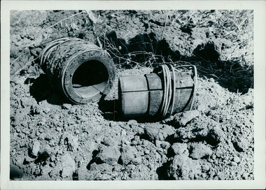 Department of Health and Human Services
Photograph, These old style water pipes fittings, built with wood, were unearthed when excavating the Boort hospital site in 1961. The pipe on the right has a sleeve that is engineered to fit into the piece on the left - Note the wire that binds the wood together - Black & White Photos
... These old style water pipes fittings, built with wood, were unearthed when excavating the Boort hospital site in 1961. The pipe on the right has a sleeve that is engineered to fit into the piece on the left - Note the wire that binds the wood together - Black & White Photos ...Department of Health and Human Services 50 Lonsdale St Melbourne melbourne These old style water pipes fittings, built with wood, were unearthed when excavating the Boort hospital site in 1961. The pipe on the right has a sleeve that is engineered to fit into the piece on the left - Note the wire that binds the wood together - Black & White Photos Photograph ... -
 Merbein District Historical Society
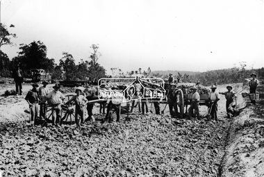
Negative, Channel Excavating, unknown
... Channel Excavating...Merbein District Historical Society 36 Box St Merbein the-murray Blocks Vineyard irrigation Channel Excavating Negative ...blocks, vineyard, irrigation -
![Photograph - Construction of the F19 [Eastern Freeway], Ron Setford, May 1976](/media/collectors/550653872162f11fb04854aa/items/6828785464071e7c58e655d0/item-media/6828788e64071e7c58e657aa/item-fit-380x285.jpg?cb=6) Kew Historical Society Inc
Kew Historical Society IncPhotograph - Construction of the F19 [Eastern Freeway], Ron Setford, May 1976
... "Excavating drainage near Chandler Hwy"...Ron Setford Eastern Freeway F19 Freeway "Excavating drainage near Chandler Hwy" Photograph Construction of the F19 [Eastern Freeway] Ron Setford ...Ron Setford and his wife Grace Setford lived in Tanner Avenue, East Kew, from c.1946 to c.1995. A keen photographer, he recorded the changing face of Kew over a 20 year period. Apart from 30 photographs of built structures and places in Kew dating from 1960 and 1961, 145 of his 35mm colour slides chronicle the development of the F19 (later renamed Eastern) Freeway through the Yarra Valley in Kew over a five year period from c.1972 to c.1977. This important collection was donated to the Society by his granddaughter in 2025.This collection of 175 35mm slides is of local and statewide significance, owing to its subject matter, particularly the major development of road transport infrastructure during the 1970s with the construction of the Eastern Freeway. The photographer also took care to annotate and date most of his slides which enable the researcher to pinpoint temporal and spatial locations."Excavating drainage near Chandler Hwy"ron setford, eastern freeway, f19 freeway -
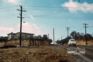
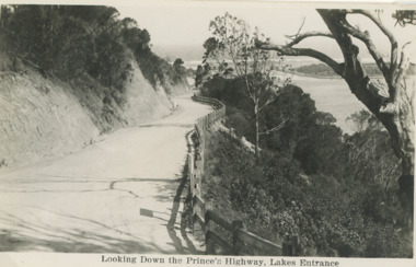 Lakes Entrance Historical Society
Postcard - Princes Highway Lakes Entrance, 1930 c
... Princes Highway Jemmys Point showing gravel road post and rail fence freshly excavated cliff with Entrance glimpses in distance Lakes Entrance Victoria. ...Black and white postcard taken of Princes Highway Jemmys Point showing gravel road post and rail fence freshly excavated cliff with Entrance glimpses in distance Lakes Entrance Victoria...Lakes Entrance Historical Society 4 Marine Parade Lakes Entrance gippsland Princes Highway Jemmys Point showing gravel road post and rail fence freshly excavated cliff with Entrance glimpses in distance Lakes Entrance Victoria. ...Princes Highway Jemmys Point showing gravel road post and rail fence freshly excavated cliff with Entrance glimpses in distance Lakes Entrance Victoria. Also a second black and white postcard taken much later of Princes Highway Jemmys Point Lakes Entrance showing sealed road with double lines in centre, post and rail fence, Entrance in distance. Donor Susan Samuel 2 January 2015. Number 04204.1Black and white postcard taken of Princes Highway Jemmys Point showing gravel road post and rail fence freshly excavated cliff with Entrance glimpses in distance Lakes Entrance VictoriaLooking Down the Princes Highway Lakes Entrancecivil engineering, roads and streets, fences -
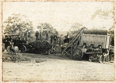 City of Moorabbin Historical Society (Operating the Box Cottage Museum)
Photograph - Photograph, 1908 Excavation commences for the Melbourne Benevolent Society, Cheltenham, 1908 Excavation commences for the Melbourne Benevolent Society, Cheltenham, 1908
... Excavating prior to the building of Melbourne Benevolent Society in Cheltenham. ...There are two horses with carriages and a large excavating machine to the right of the photograph. ...City of Moorabbin Historical Society (Operating the Box Cottage Museum) Joyce Park Jasper Road Ormond melbourne Excavating prior to the building of Melbourne Benevolent Society in Cheltenham. ...Excavating prior to the building of Melbourne Benevolent Society in Cheltenham. The Centre had begun life in 1850 in Melbourne, as the Victoria Benevolent Asylum to "relieve the aged, infirm, disabled and destitute poor of all creeds and nations and to minister to them the comfort of religion" It outgrew its North Melbourne premises so was located to a new site at Warrigal Road, Cheltenham. The foundation stone was laid in 1909, and the main buildings were completed in 1911. In 1970 the benevolent Asylum was re-named Kingston Centre. The photograph is black and white. It's a photo depicting the excavation prior to the building of Melbourne Benevolent Society in Cheltenham. The photograph shows eleven workers at the excavation site. There are two horses with carriages and a large excavating machine to the right of the photograph. benevolent asylum, benevolent society, cheltenham, train, machinery, men, society, horses, kingston centre -
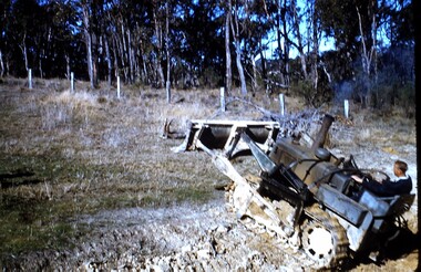 Wonga Park Community Cottage History Group
photograph, dam making, c 1940 for 1003 c1960 for 1003-1
... Ernie Kear excavating a dam in Wonga Park c 1940 ...Early dams were built by horse and scoop on the back which was handled by the orchardist, or the dam builder but later replaced by bulldozers no hard copy electronic only Ernie Kear excavating a dam in Wonga Park c 1940 dam making photograph ...Ernie Kear and his son Bruce were local excavators and involved in many projects around Wonga Park requiring bull dozing, in particular clearing land for orchards, building dams etcEarly history of Wonga Park orchard growing district. Early dams were built by horse and scoop on the back which was handled by the orchardist, or the dam builder but later replaced by bulldozersErnie Kear excavating a dam in Wonga Park c 1940 no hard copy electronic only -
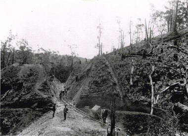
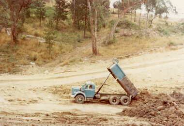 Ringwood and District Historical Society
Photograph, Where Kubis Drive, North Ringwood lifts out of the gully and turns north in Dec 1977
... The truck is dumping loam excavated from the ancient watercourse into the park area of the gully...The truck is dumping loam excavated from the ancient watercourse into the park area of the gully Part of a 101-photo record of the development of the "Bel Air" Estate, Ringwood North, including road works to Debbie Place, Kubis Drive, Jenkins Close, Burlock Avenue, Pamela Court, Manuelo Terrace, Lyn Court, Rudolf Court, Werac Drive, Iluka Place and Glenvale Road. ...Part of a 101-photo record of the development of the "Bel Air" Estate, Ringwood North, including road works to Debbie Place, Kubis Drive, Jenkins Close, Burlock Avenue, Pamela Court, Manuelo Terrace, Lyn Court, Rudolf Court, Werac Drive, Iluka Place and Glenvale Road. From the Jack Lundy Clarke collection (39 Burlock Avenue, North Ringwood) of photos taken from 1976 to 1982. The developer, Mr Kubis, named streets after his family and associates.The truck is dumping loam excavated from the ancient watercourse into the park area of the gully -
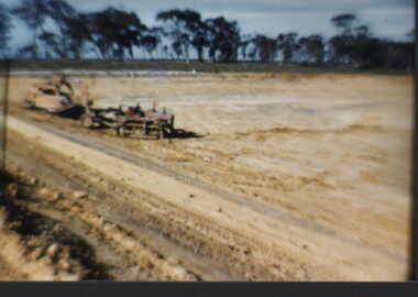
Tatura Irrigation & Wartime Camps Museum
Photograph, 1950
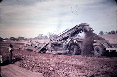
... Gradall machine excavating trench for beaching...Gradall machine excavating trench for beaching Photograph ...Taken by photographer for State Rivers and Water Supply Commission.Medium sized black and white photograph. Gradall machine excavating trench for beachinggoulburn weir, victorian state rivers and supply commission -
 Bendigo Historical Society Inc.
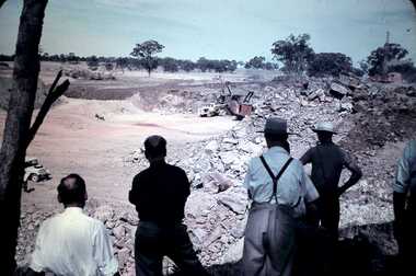
Slide - DAVID MCDONALD COLLECTION: EPPALOCK. CONSTRUCTION, c1960
... Construction. Machinery excavating what was farming area to make way for Lake Eppalock....Construction. Machinery excavating what was farming area to make way for Lake Eppalock. ...Eppalock. Construction. Machinery excavating what was farming area to make way for Lake Eppalock.Agfacolorcivil engineering, water supply, eppalock -
 Bendigo Historical Society Inc.
Slide - DAVID MCDONALD COLLECTION: EPPALOCK. CONSTRUCTION, c1960
... Eppalock. Construction. Excavating earth to form Lake Eppalock. Men looking on from the shade....History House 11 Mackenzie Street Bendigo goldfields CIVIL ENGINEERING Water supply Eppalock Agfacolor Eppalock. Construction. Excavating earth to form Lake Eppalock. Men looking on from the shade. ...Eppalock. Construction. Excavating earth to form Lake Eppalock. Men looking on from the shade.Agfacolorcivil engineering, water supply, eppalock -
 Linton and District Historical Society Inc
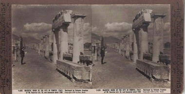
Stereograph, The Rose Stereographs, Melbourne, Sydney, Wellington and London, 14, 651 Majestic Ruins of the City of Pompeii, Italy, Copyright 1912
... Vesuvius A.D. 79, and Excavated about 1764....Vesuvius A.D. 79, and Excavated about 1764. Stereograph of two black and white images showing a man standing in front of the ruins of Pompeii. 14, 651 Majestic Ruins of the City of Pompeii, Italy Stereograph The Rose Stereographs, Melbourne, Sydney, Wellington and London ...One of two sets of stereographs donated by the O'Beirne family along with a stereoscope for viewing (Stereoscope is Registration no. 2014-51).Stereograph of two black and white images showing a man standing in front of the ruins of Pompeii.14,651. MAJESTIC RUINS OF THE CITY OF POMPEII, ITALY. Destroyed by Volcanic Eruption / of Mt. Vesuvius A.D. 79, and Excavated about 1764.stereographs -
Tatura Irrigation & Wartime Camps Museum
Photograph, 1953
... Walking Dragline - scoop filled with earth excavating channel....Walking Dragline - scoop filled with earth excavating channel. Photograph ...Taken by photographer for State Rivers and Water Supply Commission.Medium sized black and white photograph. Bucyrus Eric 6 yd. Walking Dragline - scoop filled with earth excavating channel.goulburn weir, victorian state rivers and supply commission -
 Kew Historical Society Inc
Photograph - Construction of the electric tram line in Riversdale Road, Camberwell
... Digital copy of an original mounted photograph showing workers excavating Riversdale Road, Camberwell, in preparation for the laying of the new electric tramline....Theme -- Travelling by tram Verso: "Riversdale Road between Wattle Valley and Highfield Roads" Digital copy of an original mounted photograph showing workers excavating Riversdale Road, Camberwell, in preparation for the laying of the new electric tramline. ...One of a series of photographs, taken by Edgar James Dower in the second decade of the twentieth century. Born and raised in Olinda, his family later moved to Surrey Hills. He worked as an adult as a clerk in the city office of the Metropolitan Gas Company, and in his role as a 'collector', he was able to photograph scenes including the construction of tramlines, railways and associated buildings in Kew, Hawthorn, Camberwell and Surrey Hills. Later he established a real estate agency with his brother - the E.J. Dower Real Estate Agency, Dandenong Office.The image is an historically significant record of the development of transport infrastructure which was used to connect Victorians in the first two decades of the twentieth century. This development resulted from increases in population and the consequent extension of Melbourne's suburbs. The photographs, both individually and collectively, richly detail the labour of workers and the tools and machinery used to create and extend Melbourne's public transport network in the years preceding and during World War 1.Digital copy of an original mounted photograph showing workers excavating Riversdale Road, Camberwell, in preparation for the laying of the new electric tramline.Verso: "Riversdale Road between Wattle Valley and Highfield Roads"theme -- connecting victorians by transport and communications, riversdale road - camberwell (vic.), theme -- travelling by tram -
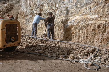
 St Patrick's Old Collegians Association (SPOCA)
Photograph - History, XC Archives
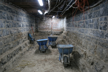
... XC Archives Project - Excavating 1 of 7 new rooms that will be used for archiving SPJC & SPOCA memorabilia. (24 July 2018)...St Patrick's Old Collegians Association (SPOCA) Formerly Cnr of Cathedral Place & Lansdowne Street East Melbourne melbourne XC Archives Project - Excavating 1 of 7 new rooms that will be used for archiving SPJC & SPOCA memorabilia. (24 July 2018) Photograph History, XC Archives ... -
 Bendigo Historical Society Inc.
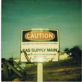
Photograph - CASTLEMAINE GAS COMPANY COLLECTION: PHOTO CAUTION SIGN
... Caution Sign Gas and Fuel Corporation of Victoria - Gas Supply Main - Expose by Hand Before Excavating Mechanically - Location and Date Unknown...ORGANISATION Industry gas and fuel Polaroid Caution Sign Gas and Fuel Corporation of Victoria - Gas Supply Main - Expose by Hand Before Excavating Mechanically - Location and Date Unknown Photograph CASTLEMAINE GAS COMPANY COLLECTION: PHOTO CAUTION SIGN ...Caution Sign Gas and Fuel Corporation of Victoria - Gas Supply Main - Expose by Hand Before Excavating Mechanically - Location and Date UnknownPolaroidorganisation, industry, gas and fuel -
 Bendigo Historical Society Inc.
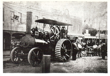
Photograph - BASIL MILLER COLLECTION: PHOTOGRAPHIC COPY OF STEAM TRACTION ENGINE
... Black and white photo copy of steam traction engine and plough on Pall Mall excavating street for new tram tracks. Note Van Dam's Tobacconist behind the engine. ...Written on back in blue ink 'Bendigo - Steam Traction Engine and plough in Pall Mall, excavating for new tram track. Copied from ''The Bendigonian'', 2/12/1902'. ...BHS CollectionBlack and white photo copy of steam traction engine and plough on Pall Mall excavating street for new tram tracks. Note Van Dam's Tobacconist behind the engine. Written on back in blue ink 'Bendigo - Steam Traction Engine and plough in Pall Mall, excavating for new tram track. Copied from ''The Bendigonian'', 2/12/1902'.person, individual, basil miller -
Tatura Irrigation & Wartime Camps Museum
Photograph, Goulburn Waranga Main Channel Construction, 1957
... Landscape scene depicting newly excavated ground with solitary man within scene....Landscape scene depicting newly excavated ground with solitary man within scene. ...Taken by photographer for State Rivers and Water Supply Commission.Large black and white photograph dry mounted on to cream board. Landscape scene depicting newly excavated ground with solitary man within scene.Below photograph: "GOULBURN WARANGA MAIN CHANNEL CONSTRUCTION / CHANNEL EXCAVATION AND BEACHING / LOOKING DOWNSTREAM" victoria state rivers and water supply commission, goulburn waranga main channel, goulburn, waranga -
 Bendigo Military Museum
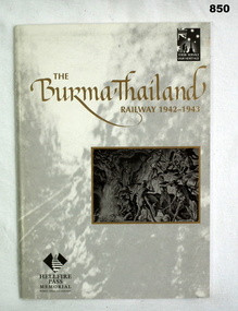
Book, Dr Richard Reid, The Burma Thailand Railway 1942 - 1943, c.1998
... Small inset of picture of drawing of men working underground excavating a cutter....Small inset of picture of drawing of men working underground excavating a cutter. The Burma Thailand Railway 1942 - 1943 Book BOOK Dr Richard Reid Department of Veteran's Affairs ...Soft cover book, 34 pages, background on cover black & white photo of railway. Small inset of picture of drawing of men working underground excavating a cutter.Written on title page in pen: Donated by Bgo YMCAbooks, military, history, forced labour -
Glenelg Shire Council Cultural Collection
Photograph - Photograph - Bridgewater Construction, n.d
... Men working on scaffolding for concrete pylons, in excavated area. Two houses on right....Men working on scaffolding for concrete pylons, in excavated area. Two houses on right. Photograph Photograph - Bridgewater Construction ...Port of Portland Authority ArchivesFront: Back- Margin ruled in pencil, diagonal in pencil. 'C' 4x2 1/4 - Pencil 'Bridgewater road bridge 29/3/57 looking s.s.w'- written in blue biro. 'Otway Street Bridge - Pencilport of portland archives, otway street bridge, bridgewater road bridge construction -
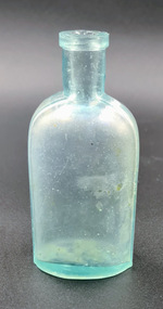 Nepean Historical Society
Domestic object - Blue/green glass bottle
... Excavated from No 7 Cooper Grove (which was originally near the old Ophir Guest House), when they were excavating for a swimming pool for Mr and Mrs Robert Riley several years ago...Nepean Historical Society 827 Melbourne Road Sorrento mornington-peninsula Excavated from No 7 Cooper Grove (which was originally near the old Ophir Guest House), when they were excavating for a swimming pool for Mr and Mrs Robert Riley several years ago Bottles Ponds Extract. 1846 Blue/green glass bottle Domestic object Blue/green glass bottle ...Excavated from No 7 Cooper Grove (which was originally near the old Ophir Guest House), when they were excavating for a swimming pool for Mr and Mrs Robert Riley several years agoBlue/green glass bottlePonds Extract. 1846bottles -
 Otway Districts Historical Society
Photograph, Brucker, Powneys Cutting being excavated, c.1902, c.1902
... Powneys Cutting being excavated by four men, two men on either side of the slope, and a horse at the end of the line, in c.1902....Powneys Cutting being excavated, c.1902. Photograph Brucker ...Because of the vast quantity of piles for harbour works Pettit Bros. of Geelong arranged for an addition siding to be installed at Ferguson on the north side of the station in 1913. They then laid a tramway in a northerly direction along the original alignment of Charley's Creek road to the top of Powneys Cutting, 1.8 km from Ferguson, where a log winch was sited. This powerful winch hauled carefully selected piles from the north-west. Jim Facey and Jim, Ted and Tom Cashin formed a partnership to log an area along the Charley's Creek Road six kilometres from Ferguson, operating full-time from 1934. After leasing three Crown sites and cutting them out the partners shifted logging operations to Powneys farm, which they had purchased, and laid a log trail into the farm. The old road reserve was also purchased, and the log tram continued along the road reserve for one kilometre to Powneys Cutting. Logs were winched up to the tramline and despatched to the mill along the falling grade of the road.B/W. 201mm x 268mm. Powneys Cutting being excavated by four men, two men on either side of the slope, and a horse at the end of the line, in c.1902.ferguson; powneys cutting; tramways; powneys farm; pettit; jim facey; jim cashin; ted cashin; tom cashin; charley's creek road; -
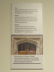 Ballarat Heritage Services
Photograph - Colour, Sign, Greenwich Chapel and Museum, England
... This was excavated in 1971 in the Grand Square. ...This was excavated in 1971 in the Grand Square. greenwich, stone, museum, chapel Sign, Greenwich Chapel and Museum, England Photograph - Colour ...The picture on the sign shows the door surround, St James's Palace. the portcullis decoration on the top right hand corner is very similar to the spandrel stone excavated at Greenwich. Top shows the stone coping at the base of a crenel opening in a crenellated battlement wall, excavated in 1971 in the grand square; the middle shows the window spandrel, possibly from a two light window similar to the reconstructed window excavated in 2005/6 in the Queen Anne car park; and the bottom shows the tudor portcullis heraldic decoration, carved into an arched spandrel stone formng part of an archway over a door. This was excavated in 1971 in the Grand Square. greenwich, stone, museum, chapel -
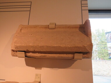 Ballarat Heritage Services
Photograph - Colour, Greenwich Chapel and Museum, England
... This was excavated in 1971 in the Grand Square. ...This was excavated in 1971 in the Grand Square. greenwich, stone, museum, chapel Greenwich Chapel and Museum, England Photograph - Colour ...The picture on the sign shows the door surround, St James's Palace. the portcullis decoration on the top right hand corner is very similar to the spandrel stone excavated at Greenwich. Top shows the stone coping at the base of a crenel opening in a crenellated battlement wall, excavated in 1971 in the grand square; the middle shows the window spandrel, possibly from a two light window similar to the reconstructed window excavated in 2005/6 in the Queen Anne car park; and the bottom shows the tudor portcullis heraldic decoration, carved into an arched spandrel stone formng part of an archway over a door. This was excavated in 1971 in the Grand Square. greenwich, stone, museum, chapel