Showing 4 items matching "extinct in this area."
-
 Buninyong & District Historical Society
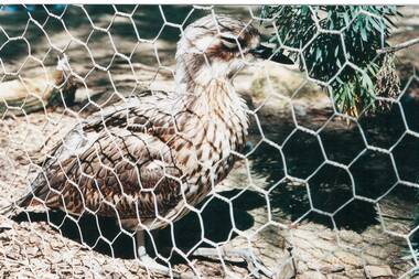
Photograph - Photograph of a Curlew, the symbol of Moorabool Shire, Photograph of a Curlew, a bird now extinct in this area
... Photograph of a Curlew, a bird now extinct in this area.......Extinct in this area....Photograph of a Curlew, a bird now extinct in this area. Picture taken at Bulker's Winery, near Rutherglen in October 1997....Buninyong & District Historical Society Old Court House, Buninyong Town Hall 313 Learmonth Street Buninyong goldfields Bird Extinct in this area. Photograph of a Curlew, a bird now extinct in this area. ...Photograph of a Curlew, a bird now extinct in this area. Picture taken at Bulker's Winery, near Rutherglen in October 1997.bird, extinct in this area. -
 City of Ballarat
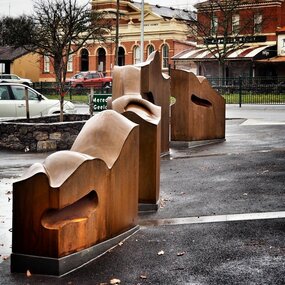
Artwork, other - Public Artwork, Cliff Burtt, Buninyong Bivium, 2016
... extinct volcano Mt. Buninyong. Traditional land of the Wadawurrung people, today the area remains a significant site for the culture of indigenous people and their connection to the land. ...extinct volcano Mt. Buninyong. Traditional land of the Wadawurrung people, today the area remains a significant site for the culture of indigenous people and their connection to the land. ...Buninyong Bivium (2016) by Cliff Burtt engages with the geography and history of the Buninyong region in both pre and post settlement. The town of Buninyong is dominated by the profiles of Mt Helen and the extinct volcano Mt. Buninyong. Traditional land of the Wadawurrung people, today the area remains a significant site for the culture of indigenous people and their connection to the land. The profile of this sculpture is based on topographical mapping of the area, depicting sections of the landscape. The gaps between the elements of the work can be viewed as representations of the shafts sunk into the earth by the early gold miners and compound curves on the upper surfaces are mirroring the topography of the area, while cut-aways in the sides are suggestive of rock strata.The artwork is of aesthetic and social significance to the people of BallaratCorten steel sculpture made of five unique sculptural pieces secured to at concreate base at pavement levelbuninyong, cliff burtt, sculpture, public art, mining, ballarat -
 Victorian Aboriginal Corporation for Languages
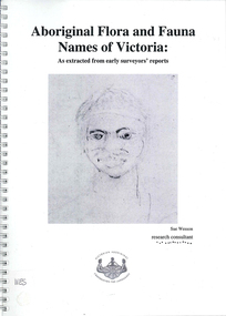
Book, Sue Wesson et al, Aboriginal flora and fauna names of Victoria : as extracted from early surveyors' reports, 2001
... extinct. For example, magpie geese, eastern quolls, bustards and pademelons were assigned names in the Jardwadjali language area of the upper Glenelg and Wimmera Rivers. ...extinct. For example, magpie geese, eastern quolls, bustards and pademelons were assigned names in the Jardwadjali language area of the upper Glenelg and Wimmera Rivers. ...The Flora and Fauna Names Project is an initiative of the Victorian Aboriginal Corporation for Languages and the Victorian Biodiversity Strategy. The researcher has examined material from the archives of the Department of Natural Resources and Environment (NRE), the State Library of Victoria, the Victorian Public Records Office and the Australian Archives Office. This first stage of the project focussed on the NRE archives, in particular the field notebooks of the earliest surveyors and their maps although other NRE resources, libraries and public records were accessed. A total of 3028 words were found of which a significant proportion have previously been unknown to linguists. It appears that the place names and word lists in early surveyors notebooks, the 1858 surveyors responses to the Surveyor General and an extensive Wiradjuri wordlist by James Baylis have not yet been widely used or published. Fifteen percent of these 3028 words describe flora and fauna and six percent describe habitat. Of particular interest is the evidence provided by these lists of the existence of fauna in the mid nineteenth century in regions where it is now extinct. For example, magpie geese, eastern quolls, bustards and pademelons were assigned names in the Jardwadjali language area of the upper Glenelg and Wimmera Rivers. The outcomes of this project may help to assist in ascertaining the distribution of flora and fauna assets in Victoria.maps, b&w photographs, colour photographs, illustrations, word listswiradjuri, jardwadjali, glenelg river, wimmera river -
 Bendigo Historical Society Inc.
Newspaper - Fortuna Articles - "Steeped in Mystery", Dec 01 2007
... extinct Thylacoleo (Marsupial Lion). The Goldfields are reputed to be home to many ghosts, with frequent reports from locations such as Camp Hill Primary School, Castlemaine's Theatre Royal, and especially the historic Fortuna Villa.Accounts from both military personnel and civilians describe unexplained voices, apparitions, and other paranormal events within these historic buildings. Specific stories include encounters with apparitions, mysterious voices, and doors opening on their own, often witnessed by credible sources like army sergeants and captains. The document also references other unexplained phenomena in the region, such as UFO sightings and missing people, contributing to the area's...extinct Thylacoleo (Marsupial Lion). The Goldfields are reputed to be home to many ghosts, with frequent reports from locations such as Camp Hill Primary School, Castlemaine's Theatre Royal, and especially the historic Fortuna Villa.Accounts from both military personnel and civilians describe unexplained voices, apparitions, and other paranormal events within these historic buildings. Specific stories include encounters with apparitions, mysterious voices, and doors opening on their own, often witnessed by credible sources like army sergeants and captains. The document also references other unexplained phenomena in the region, such as UFO sightings and missing people, contributing to the area's ...This document explores the myths, legends, and mysterious phenomena of the Goldfields region in Australia, focusing on several recurring themes: Numerous reports of large, exotic cats (such as black panthers and pumas) have been recorded in Victoria, with over 4,500 sightings documented by the Australian Rare Fauna Research Association since 1984.Notable individuals, like John Higgins and Paul Clacher, have provided detailed accounts and physical evidence (e.g., large footprints) supporting the existence of these animals. Theories about their origins include escaped zoo or circus animals, mascots released by American servicemen after WWII, or even the survival of the supposedly extinct Thylacoleo (Marsupial Lion). The Goldfields are reputed to be home to many ghosts, with frequent reports from locations such as Camp Hill Primary School, Castlemaine's Theatre Royal, and especially the historic Fortuna Villa.Accounts from both military personnel and civilians describe unexplained voices, apparitions, and other paranormal events within these historic buildings. Specific stories include encounters with apparitions, mysterious voices, and doors opening on their own, often witnessed by credible sources like army sergeants and captains. The document also references other unexplained phenomena in the region, such as UFO sightings and missing people, contributing to the area's reputation for mystery and intrigue.Fortuna Article - "Steeped in Mystery" Dec 01 2007 by Sarah Harris This item contains the following: 11217.33a Colour Photo of Fortuna, once home to the Lansell family, Fortuna Villa is now occupied by the Department of Imagery and Geospatial Organistion mapping unit, and apparently, some apparitions 11217.33b Colour Photo of Russel Henthorn with his camera and gear he used for a UFO photo in 1983 11217.33c Part of Page 4 - Article "Steeped in Mystery" non-fictionbendigo, fortuna, george lansell, russell henthorn