Showing 728 items matching "family huts "
-
 Tatura Irrigation & Wartime Camps Museum
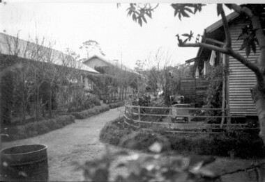
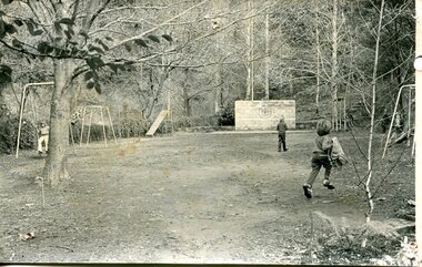
Photograph, Compound B Row of family huts, 1945
... Compound B Row of family huts......family huts & gardens...photo inside compound B. Row of family huts in 1945, pram on front "verandah" on right, mounted on foam core...Row of family huts in 1945, pram on front "verandah" on right, mounted on foam core Compound B Row of family huts Photograph Photograph ...photo taken in 1945 inside Templer compound Camp 3 Taturaphoto inside compound B. Row of family huts in 1945, pram on front "verandah" on right, mounted on foam corecamp 3, family huts & gardens, templer compound, compound b, internees, aberle, gerd -
 Stawell Historical Society Inc
Photograph, Mr Norman McDonald & Mrs Margaret McDonald nee Unknown with some of their Family at Borough Huts
... Mr Norman McDonald & Mrs Margaret McDonald nee Unknown with some of their Family at Borough Huts...Borough Huts Scene of Norman and Margaret McDonald and some of their Family. There were 15 children of the marriage. ...Grampians mountains in background. stawell houses Mr Norman McDonald & Mrs Margaret McDonald nee Unknown with some of their Family at Borough Huts Photograph ...Borough Huts Scene of Norman and Margaret McDonald and some of their Family. There were 15 children of the marriage. Grampians mountains in background.stawell houses -
 Port Melbourne Historical & Preservation Society
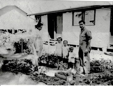
Photograph - Garden area outside Nash family hut Fishermens''s Bend Migrant Hostel, c.1955
... Garden area outside Nash family hut Fishermens''s Bend Migrant Hostel....Girl in garden outside Nash family hut Fishermen's Bend Migrant Hostel. One of eleven digital images of the Nash family's migration to Australia & their time at the Fishermens''s Bend Migrant Hostel & their home at 319 Princes Street....Photograph Garden area outside Nash family hut Fishermens''s Bend Migrant Hostel. ...Girl in garden outside Nash family hut Fishermen's Bend Migrant Hostel. One of eleven digital images of the Nash family's migration to Australia & their time at the Fishermens''s Bend Migrant Hostel & their home at 319 Princes Street.immigration, fishermens bend migrant hostel, nash family, princes street -
Port Melbourne Historical & Preservation Society
Photograph - Plan of Nash family hut Fishermens''s Bend Migrant Hostel, c.1955
... Plan of Nash family hut Fishermens''s Bend Migrant Hostel....Hand drawn plan of the Nash family hut Fishermen's Bend Migrant Hostel. One of eleven digital images of the Nash family's migration to Australia & their time at the Fishermens''s Bend Migrant Hostel & their home at 319 Princes Street....Photograph Plan of Nash family hut Fishermens''s Bend Migrant Hostel. ...Hand drawn plan of the Nash family hut Fishermen's Bend Migrant Hostel. One of eleven digital images of the Nash family's migration to Australia & their time at the Fishermens''s Bend Migrant Hostel & their home at 319 Princes Street.immigration, fishermens bend migrant hostel, nash family, princes street -
Port Melbourne Historical & Preservation Society
Photograph - Garden outside Nash family hut Fishermens''s Bend Migrant Hostel, c.1955
... Garden outside Nash family hut Fishermens''s Bend Migrant Hostel....Girl weeding garden outside Nash family hut Fishermen's Bend Migrant Hostel. One of eleven digital images of the Nash family's migration to Australia & their time at the Fishermens''s Bend Migrant Hostel & their home at 319 Princes Street....Photograph Garden outside Nash family hut Fishermens''s Bend Migrant Hostel. ...Girl weeding garden outside Nash family hut Fishermen's Bend Migrant Hostel. One of eleven digital images of the Nash family's migration to Australia & their time at the Fishermens''s Bend Migrant Hostel & their home at 319 Princes Street.immigration, fishermens bend migrant hostel, nash family, princes street -
Port Melbourne Historical & Preservation Society
Photograph - Female & child with fire hose Fishermens''s Bend Migrant Hostel, c.1955
... Female & boy with fire hose posing outside Nash family hut Fishermen's Bend Migrant Hostel. One of eleven digital images of the Nash family's migration to Australia & their time at the Fishermens''s Bend Migrant Hostel & their home at 319 Princes Street....Port Melbourne Historical & Preservation Society Port Melbourne Town Hall 333 Bay Street Port Melbourne melbourne Immigration Fishermens Bend Migrant Hostel NASH family Princes Street Female & boy with fire hose posing outside Nash family hut Fishermen's Bend Migrant Hostel. One of eleven digital images of the Nash family's migration to Australia & their time at the Fishermens''s Bend Migrant Hostel & their home at 319 Princes Street. ...Female & boy with fire hose posing outside Nash family hut Fishermen's Bend Migrant Hostel. One of eleven digital images of the Nash family's migration to Australia & their time at the Fishermens''s Bend Migrant Hostel & their home at 319 Princes Street.immigration, fishermens bend migrant hostel, nash family, princes street -
Tatura Irrigation & Wartime Camps Museum
Photograph - German Internee Camp 3, 1945
... Black and white photograph of 3 families in hut group. 1 lady, 3 men standing back row; Front row: 1 boy, mother nursing baby, 2 young boys, 1 standing 1 seated the elderly lady seated, 1 mother and son....Tatura Irrigation & Wartime Camps Museum 49 Hogan Street Tatura the-murray The Steller, Froeschle and Haering families. internee children camp 3 froeschle family haering family steller family the number 769 centre front Black and white photograph of 3 families in hut group. 1 lady, 3 men standing back row; Front row: 1 boy, mother nursing baby, 2 young boys, 1 standing 1 seated the elderly lady seated, 1 mother and son. ...The Steller, Froeschle and Haering families.Black and white photograph of 3 families in hut group. 1 lady, 3 men standing back row; Front row: 1 boy, mother nursing baby, 2 young boys, 1 standing 1 seated the elderly lady seated, 1 mother and son.the number 769 centre frontinternee children, camp 3, froeschle family, haering family, steller family -
 Tatura Irrigation & Wartime Camps Museum
Photograph, Fortuna Family 1941/2
... Photograph is of the Fortuna family outside their hut. Photograph taken in 1942. Second copy of picture in file....Photograph is of the Fortuna family outside their hut. Photograph taken in 1942. Second copy of picture in file. john fortuna con fortuna camp 3a rushworth mafalda fortuna Black and white photograph of 2 adults and 3 children standing in a garden in front of a hut. ...Fortuna family were internees in Camp 3A during WW2. Photograph is of the Fortuna family outside their hut. Photograph taken in 1942. Second copy of picture in file.Black and white photograph of 2 adults and 3 children standing in a garden in front of a hut. john fortuna, con fortuna, camp 3a rushworth, mafalda fortuna -
Tatura Irrigation & Wartime Camps Museum
Document - Family History, John Dickson Love
... History of John Dickson Love and family.|Photo of log hut and fencing on their property....History of John Dickson Love and family.|Photo of log hut and fencing on their property. ...Material borrowed for copying. History of John Dickson Love and family.|Photo of log hut and fencing on their property.Borrowed for copying -
 Tatura Irrigation & Wartime Camps Museum
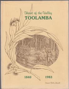
Book, Stewart (Bill)Morvell et al, Heart of the Valley, Toolamba 1840-1983, 1983
... Sketch of gum leaves surrounding a scene of bush log hut. Family with man cutting trees. From a wood carving by Nicholas Bartels. 2nd copy. ...Sketch of gum leaves surrounding a scene of bush log hut. Family with man cutting trees. From a wood carving by Nicholas Bartels. 2nd copy. ...Written to accurately record the history of Toolamba. From early days of Hume and Hovell, agriculture, schools, churches, sport and recreation. Names on Roll of Teachers and Pupils.Brown hard cover. Title in gold writing. Cream dust jacket, green writing. Sketch of gum leaves surrounding a scene of bush log hut. Family with man cutting trees. From a wood carving by Nicholas Bartels. 2nd copy. L3458.toolamba -
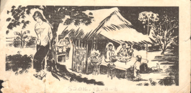 National Vietnam Veterans Museum (NVVM)
Document, Joint US Public Office (JUSPAO), Propaganda Leaflet, 1962 (Approximate)
... Picture of a traditional hut with family around table. Lady with her hands tied behind her back under nearby tree. ...Picture of a traditional hut with family around table. Lady with her hands tied behind her back under nearby tree. ...Black and white leaflet. Picture of a traditional hut with family around table. Lady with her hands tied behind her back under nearby tree. All writing in Vietnamese script.leaflet, propaganda, sgt a moylan, 4 platoon, b coy, 7 rar, 7th battalion, 16063, royal australian infantry corps, arnold george moylan -
 Tatura Irrigation & Wartime Camps Museum
Photograph, Camp Hospital Huts
... This was the original camp 13 hospital hut which was bought at Auction by Bill & Joyce Baker and Ian & Ethel Stone. Joyce and Ethel were twin sisters. The 2 families...Tatura Irrigation & Wartime Camps Museum 49 Hogan Street Tatura the-murray This was the original camp 13 hospital hut which was bought at Auction by Bill & Joyce Baker and Ian & Ethel Stone. Joyce and Ethel were twin sisters. The 2 families ...This was the original camp 13 hospital hut which was bought at Auction by Bill & Joyce Baker and Ian & Ethel Stone. Joyce and Ethel were twin sisters. The 2 families purchased the hut in 1948, the hut was brought to their allotment in Ross Street, and converted into a residence.2 small black and white photographs. 1 depicts a hut on the back of a truck and the other of same hut in situ before being moved.camp 13 hospital hut, baker, bill & joyce, photograph, people -
 Lakes Entrance Historical Society
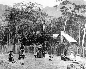
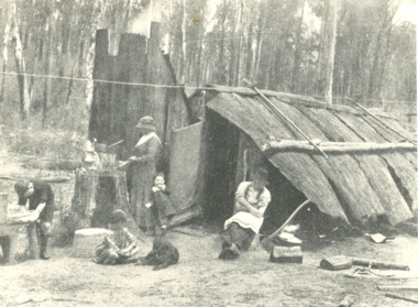
Photograph - Bark hut near Nowa Nowa Victoria, H D Bulmer, 1910 c
... Black and white photograph of a settler and his family around their bark hut in the bush. A primitive shelter of bark slabs stabilised with a log and iron frame attached to roof ridge. ...Lakes Entrance Historical Society 4 Marine Parade Lakes Entrance gippsland Houses Settlers Black and white photograph of a settler and his family around their bark hut in the bush. A primitive shelter of bark slabs stabilised with a log and iron frame attached to roof ridge. ...Black and white photograph of a settler and his family around their bark hut in the bush. A primitive shelter of bark slabs stabilised with a log and iron frame attached to roof ridge. Situated near Nowa Nowa Victoriahouses, settlers -
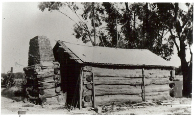 Bendigo Historical Society Inc.
Photograph - BURNT GULLY PHOTOS, 1924
... Pioneer log cabin Burnt Gully, the home of the Grafton family, demolished about 1930. Hut of slab construction, with corruated iron roof over timber slats. ...Pioneer log cabin Burnt Gully, the home of the Grafton family, demolished about 1930. Hut of slab construction, with corruated iron roof over timber slats. ...Burnt Gully - possibly near Woodvale. a. Black and white photo: men standing behind, alongside bagged grain. Steam farm engine on RH side. Written on rear of photo: threshing team at lunch engine Ruston Procter steam. 8 horse power, single cylinder, working pressure 75 lbs per square inch. 80 revs per minte. Fly wheel 6 feet in diameter. b. Pilcher's thresher on Robert Riley's farm, Burnt Gully. Bullock drivers Bill Pilcher, Paddy Mulcair. Bullock drawn threshing machine, large group of men standing alongside and to rear of machine. Two men standing on top of thresher. Steam traction engine on far left of photo. c. Pioneer log cabin Burnt Gully, the home of the Grafton family, demolished about 1930. Hut of slab construction, with corruated iron roof over timber slats. Chimney of logs and slabs topped with bricks on LH side of house. Steam farm machine in background on LH side.unknownagriculture, farm, grafton familyh, robert riley, bill pilcher, paddy mulcair, burnt gully. -
 Falls Creek Historical Society
Photograph - Jack Maddison Leading horses on the Bogong High Plain
... Maddison Family Mt Beauty...Maddison's Hut...The Maddison family built Aertex Hut at the top of T Spur at Mt. ...The Maddison family built Aertex Hut at the top of T Spur at Mt. ...The images in the Bogong Village Collection were displayed in Bogong Jack’s Tavern for over 20 years and were donated to the Falls Creek Museum when the Tavern closed in 2021. In 1939, the State Electricity Commission of Victoria established a field headquarters at Bogong to house workers and their families for the Kiewa Hydroelectric Scheme which ran from the 1930s to the 1960s. The workmen's camp was originally started with tents and was called Junction Camp. By 1947, the village supported 300 workers and their families. It included 40 houses, a hostel for single staff, a post office, a police station, a medical centre, and a primary school. The staff hostel was known as Kiewa House. At the completion of the Scheme, in the 1960s, the village was opened to public/tourism use. In 1968 the Victorian Education Department acquired the camp buildings and four houses from the State Electricity Commission of Victoria to establish an Outdoor Education Centre which operated for over 50 years. The Kiewa Hydroelectric Scheme was privatized in the 1990s and sold to Southern Hydro, before being acquired by AGL in 2005. In 2023 the Grollo Group signed a 73 year sublease on Bogong Village and has plans for its redevelopment as a workers’ village. John Maddison and his wife Mary Padman emigrated from London to Australia in 1850 with their five sons. Jack (John James William Maddison) was one of their great grandsons. In 1877 Jack’s grandfather George Maddison selected land between the East and West Kiewa branches of the Kiewa River - known as the "Island". It is now known as Mount Beauty. The Maddison family built Aertex Hut at the top of T Spur at Mt. Bogong for use when grazing cattle. It later became known as Maddison's Hut. Staircase Spur walking track at Bogong was formerly known as Maddison’s Track as it is the path once used by the Maddison family to drive their cattle on to the high plains. These images are significant because they feature the son of a pioneering family on the Bogong High Plains.A black and white photograph of Jack Maddison leading horses on the Bogong High Plains.bogong alpine village, bogong high plains, maddison family mt beauty, maddison's hut, aertex hut, -
 Eltham District Historical Society Inc
Photograph - Digital Photograph, Alan King, Blue Lake, Plenty Gorge Park, 2008
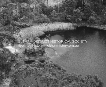
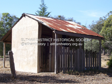
... This was a rare and late example of a slab hut with a domestic orchard close to Melbourne. Emmet Watmough and his family first occupied the hut, followed by a succession of families, until the Bell family bought it around 1948. ...This was a rare and late example of a slab hut with a domestic orchard close to Melbourne. Emmet Watmough and his family first occupied the hut, followed by a succession of families, until the Bell family bought it around 1948. ...A quarry was transformed into the Blue Lake. Published: Nillumbik Now and Then / Marguerite Marshall 2008; photographs Alan King with Marguerite Marshall.; p179 The dramatic steep-sided Plenty Gorge lies along the divide of two geological areas, and separates the Nillumbik Shire and the City of Whittlesea. On the Nillumbik side are undulating hills and sedimentary rock, and in Whittlesea, lies a basalt plain formed by volcanic action up to two million years ago. This provides the Plenty Gorge Park with diverse vegetation and habitats, making it one of Greater Melbourne’s most important refuges for threatened and significant species. The park, established in 1986, consists of around 1350 hectares, and extends 11 kilometres along the Plenty River, from Greensborough to Mernda. It provides a wildlife corridor for around 500 native plant and 280 animal species. The area’s plentiful food and water attracted the Wurundjeri Aboriginal people and then European settlers. By 1837 squatters had claimed large runs of land for their sheep and cattle. The Plenty Valley was among the first in the Port Phillip District to be settled - mainly in the less heavily timbered west - and was proclaimed a settled district in 1841.But by the late 1880s, the settlers’ extensive land clearing for animal grazing, then agriculture, depleted the Wurundjeri’s traditional food sources, which helped to drive them away. Many Wurundjeri artefacts remain (now government protected), and so far 57 sites have been identified in the park, including scarred trees, burial areas and stone artefacts. Pioneer life could be very hard because of isolation, flooding, bushfires and bushrangers. Following the Black Thursday bushfires of 1851, basalt was quarried to build more fire-resistant homes. Gold discoveries in the early 1850s swelled the population, particularly around Smugglers Gully; but food production made more of an impact. In the late 1850s wheat production supplanted grazing. In the 1860s the government made small holdings available to poorer settlers. These had the greatest effect on the district, particularly in Doreen and Yarrambat, where orchards were established from the 1880s to 1914. Links with a prominent early family are the remains of Stuchbery Farm, by the river’s edge bounded by Smugglers Gully to the north and La Trobe Road, Yarrambat, to the east. The Stuchberys moved to the valley in 1890, and the family still lives in the area. In 1890, Alfred and Ada first lived in a tent where four children were born, then Alfred built the house and outbuildings around 1896. They planted an orchard, then a market garden, and developed a dairy. The family belonged to the local Methodist and tennis communities. Their grandson Walter, opened the Flying Scotsman Model Railway Museum in Yarrambat, which his widow, Vi, continues to run. Wal was also the Yarrambat CFA Captain for 22 years until 1987. Walter sold 24 hectares in 1976 for development - now Vista Court - and in 1990, the remaining 22.6 hectares for the park. Remaining are an early stone dairy and remnants of a stone barn, a pig sty and a well. Until it was destroyed by fire in 2003, a slab hut stood on the Happy Hollow Farm site, at the southern end of the park. The hut is thought to have been built in the Depression around 1893. This was a rare and late example of a slab hut with a domestic orchard close to Melbourne. Emmet Watmough and his family first occupied the hut, followed by a succession of families, until the Bell family bought it around 1948. There they led a subsistence lifestyle for 50 years, despite encroaching Melbourne suburbia. The Yellow Gum Recreation Area includes the Blue Lake, coloured turquoise at certain times of the year. Following the 1957 bushfires, this area was quarried by Reid Quarries Pty Ltd for Melbourne’s first skyscrapers, then by Boral Australia. However in the early 1970s water began seeping into the quarry forming the Blue Lake and the quarry was closed. The State Government bought the site in 1997 and opened it as a park in 1999.This collection of almost 130 photos about places and people within the Shire of Nillumbik, an urban and rural municipality in Melbourne's north, contributes to an understanding of the history of the Shire. Published in 2008 immediately prior to the Black Saturday bushfires of February 7, 2009, it documents sites that were impacted, and in some cases destroyed by the fires. It includes photographs taken especially for the publication, creating a unique time capsule representing the Shire in the early 21st century. It remains the most recent comprehenesive publication devoted to the Shire's history connecting local residents to the past. nillumbik now and then (marshall-king) collection, blue lake, plenty gorge park -
 Eltham District Historical Society Inc
Photograph - Digital Photograph, Marguerite Marshall, Stuchbery Farm dairy, 14 March 2008
... This was a rare and late example of a slab hut with a domestic orchard close to Melbourne. Emmet Watmough and his family first occupied the hut, followed by a succession of families, until the Bell family bought it around 1948. ...This was a rare and late example of a slab hut with a domestic orchard close to Melbourne. Emmet Watmough and his family first occupied the hut, followed by a succession of families, until the Bell family bought it around 1948. ...Stuchbery Farm was situated on the Plenty River bounded by Smugglers Gully to the north and La trobe Road, Yarrambat, to the east. Alan and Ada Stutchbery moved to the valley in 1890, first living in a tent where four children were born. Alfred built a home and outbuildings around 1896. They planted an orchard, then a market garden and developed a dairy. Published: Nillumbik Now and Then / Marguerite Marshall 2008; photographs Alan King with Marguerite Marshall.; p179 The dramatic steep-sided Plenty Gorge lies along the divide of two geological areas, and separates the Nillumbik Shire and the City of Whittlesea. On the Nillumbik side are undulating hills and sedimentary rock, and in Whittlesea, lies a basalt plain formed by volcanic action up to two million years ago. This provides the Plenty Gorge Park with diverse vegetation and habitats, making it one of Greater Melbourne’s most important refuges for threatened and significant species. The park, established in 1986, consists of around 1350 hectares, and extends 11 kilometres along the Plenty River, from Greensborough to Mernda. It provides a wildlife corridor for around 500 native plant and 280 animal species. The area’s plentiful food and water attracted the Wurundjeri Aboriginal people and then European settlers. By 1837 squatters had claimed large runs of land for their sheep and cattle. The Plenty Valley was among the first in the Port Phillip District to be settled - mainly in the less heavily timbered west - and was proclaimed a settled district in 1841. But by the late 1880s, the settlers’ extensive land clearing for animal grazing, then agriculture, depleted the Wurundjeri’s traditional food sources, which helped to drive them away. Many Wurundjeri artefacts remain (now government protected), and so far 57 sites have been identified in the park, including scarred trees, burial areas and stone artefacts. Pioneer life could be very hard because of isolation, flooding, bushfires and bushrangers. Following the Black Thursday bushfires of 1851, basalt was quarried to build more fire-resistant homes. Gold discoveries in the early 1850s swelled the population, particularly around Smugglers Gully; but food production made more of an impact. In the late 1850s wheat production supplanted grazing. In the 1860s the government made small holdings available to poorer settlers. These had the greatest effect on the district, particularly in Doreen and Yarrambat, where orchards were established from the 1880s to 1914. Links with a prominent early family are the remains of Stuchbery Farm, by the river’s edge bounded by Smugglers Gully to the north and La Trobe Road, Yarrambat, to the east. The Stuchberys moved to the valley in 1890, and the family still lives in the area. In 1890, Alfred and Ada first lived in a tent where four children were born, then Alfred built the house and outbuildings around 1896. They planted an orchard, then a market garden, and developed a dairy. The family belonged to the local Methodist and tennis communities. Their grandson Walter, opened the Flying Scotsman Model Railway Museum in Yarrambat, which his widow, Vi, continues to run. Wal was also the Yarrambat CFA Captain for 22 years until 1987. Walter sold 24 hectares in 1976 for development - now Vista Court - and in 1990, the remaining 22.6 hectares for the park. Remaining are an early stone dairy and remnants of a stone barn, a pig sty and a well. Until it was destroyed by fire in 2003, a slab hut stood on the Happy Hollow Farm site, at the southern end of the park. The hut is thought to have been built in the Depression around 1893. This was a rare and late example of a slab hut with a domestic orchard close to Melbourne. Emmet Watmough and his family first occupied the hut, followed by a succession of families, until the Bell family bought it around 1948. There they led a subsistence lifestyle for 50 years, despite encroaching Melbourne suburbia. The Yellow Gum Recreation Area includes the Blue Lake, coloured turquoise at certain times of the year. Following the 1957 bushfires, this area was quarried by Reid Quarries Pty Ltd for Melbourne’s first skyscrapers, then by Boral Australia. However in the early 1970s water began seeping into the quarry forming the Blue Lake and the quarry was closed. The State Government bought the site in 1997 and opened it as a park in 1999.This collection of almost 130 photos about places and people within the Shire of Nillumbik, an urban and rural municipality in Melbourne's north, contributes to an understanding of the history of the Shire. Published in 2008 immediately prior to the Black Saturday bushfires of February 7, 2009, it documents sites that were impacted, and in some cases destroyed by the fires. It includes photographs taken especially for the publication, creating a unique time capsule representing the Shire in the early 21st century. It remains the most recent comprehenesive publication devoted to the Shire's history connecting local residents to the past. nillumbik now and then (marshall-king) collection, ada stuchbery, alan stuchbery, dairy, stuchbery farm, farm buildings, yarrambat, plenty gorge park -
Warrnambool and District Historical Society Inc.
Functional object - Notebook, 1940s
... hut but later built a weatherboard house. He married Nellie Leeong Sen in 1928 and they had two children, Ruth and Nancy. The family...hut but later built a weatherboard house. He married Nellie Leeong Sen in 1928 and they had two children, Ruth and Nancy. The family ...As this notebook has the name 'Gat Sing' on the last page it is presumed that it belonged to Charles Gat Sing. He had a market garden on Mortlake Rd, Warrnambool in the first half of the 20th century. He initially lived in a hessian-lined hut but later built a weatherboard house. He married Nellie Leeong Sen in 1928 and they had two children, Ruth and Nancy. The family were well-known and respected in the Warrnambool community. Gat Sing died in 1944 and his wife died in 1989. Two of the receipts in the notebook are made out to Ruth Gat Sing and it is possible the notebook belonged to her, following the death of her father.This notebook is of considerable interest as a memento of the Chinese market gardener community in Warrnambool and of Gat Sing and his familyThis is a notebook with blank pages held in a brown leather folder by a brown cord. There is a brown ribbon on the outside of the folder for enclosing the notebook therein. The front cover has an insert folder for storing papers and the back cover has insert folders for cards, tickets and stamps. The notebook has a mottled cover, mostly in the green shades. There is a folded section at the side to enclose a pencil. There are three loose receipts in the notebook. Gat Singgat sing and family, warrnambool chinese market gardeners -
 Kiewa Valley Historical Society
Newspaper Article - Thomas Briggs, 5th March 1988
... hut and a boundary fence. In 1886 he married Annie Maria Platt parenting 5 sons and 2 daughters until Annie died in 1953, aged 86 years. Thomas Briggs was a pioneer living in the Kiewa Valley with his parents and then with wife and family. ...Thomas Briggs was a pioneer of the Tawonga District. He worked on his parent's farm, selling goods, droving pigs and travelling to Yackandandah and Bright. He worked with pick and shovel on the Tawonga to Bright Road in 1902. He took up 320 acres of wild forest in Tawonga at 10 cents per acre per year for 20 years. He built a slab and shingle hut and a boundary fence. In 1886 he married Annie Maria Platt parenting 5 sons and 2 daughters until Annie died in 1953, aged 86 years.Thomas Briggs was a pioneer living in the Kiewa Valley with his parents and then with wife and family. This article is a history of his life from 1862 until 1887. See KVHS 0850 for information on the dray used to make the Tawonga Gap road - owned by John Briggs.Newspaper article Page 34 Border Morning Mail, Saturday, March 5, 1988 - Thomas Briggs Born 3rd Nov. 1862 who lived with his family at Upper Gundowring. His travels in the area including the Tawonga Gap and its construction in 1902 and his taking up of land in Tawonga in 1880. The article finishes in 1887 when he married Annie Maria Platt. The Thos Briggs story continues next week.thomas briggs; tawonga; kiewa valley; annie platt -
 Kiewa Valley Historical Society
Photo - Bogong Village huts
... Kiewa Valley Historical Society Mount Beauty Information Centre 31 Bogong High Plains Rd Mt Beauty high-country Bogong Village was used between the 1930's -1950's by S.E.C.V. to house workers and their families on the Hydro Electricity Scheme State Electricity Commission of Victoria (S.E.C.V.) construction of the Kiewa Hydro Electric Scheme. Housing for workers Bogong Village SECV Bogong huts ...Bogong Village was used between the 1930's -1950's by S.E.C.V. to house workers and their families on the Hydro Electricity SchemeState Electricity Commission of Victoria (S.E.C.V.) construction of the Kiewa Hydro Electric Scheme. Housing for workersBlack and white photograph of House Number 1 at Bogong Villagebogong village, secv, bogong huts -
 Kiewa Valley Historical Society
Photograph - Building of Myrtleford Ski Club
... family friendly club. It was one of the earliest lodges to be built at Falls Creek and was one of the earliest ski clubs formed and celebrated its 75th anniversary in 2013. In 1949, Myrtleford Ski Club obtained permission for occupancy and began planning the MSC Lodge. There were only three other huts...family friendly club. It was one of the earliest lodges to be built at Falls Creek and was one of the earliest ski clubs formed and celebrated its 75th anniversary in 2013. In 1949, Myrtleford Ski Club obtained permission for occupancy and began planning the MSC Lodge. There were only three other huts ...Myrtleford Ski Club is a non-commercial, family friendly club. It was one of the earliest lodges to be built at Falls Creek and was one of the earliest ski clubs formed and celebrated its 75th anniversary in 2013. In 1949, Myrtleford Ski Club obtained permission for occupancy and began planning the MSC Lodge. There were only three other huts on the mountain, Bogong Ski Club in an old Army hut, Skyline as the Ski Club of Victoria lodge and the Albury Ski Club lodge. The lodge was built mostly from donated materials. The basement was dug out and lined with stone from the Ruined Castle area, timber was cut (using cross-saws) from the Walpole properties and was milled then carted up to Falls Creek on either the Walpole or Calvert trucks. The iron on the roof was originally a tobacco kiln on Billy McNamara's property. The lodge has undergone many improvements over the years including a second storey added in the 1950’s, updating of accommodation, shower and toilet facilities to meet the changing needs of members. The lodge now caters for 38 people in a variety of shared rooms from two to eight beds per room. Toilet and shower facilities are also shared. The club has a Lodge Managers for the winter season. Myrtleford Ski Lodge was one of the earliest ski lodges built in the Falls Creek area in 1938. It is an excellent example of early sporting and community activities in the Upper Kiewa Valley area. Photograph shows family members, including women, involved in the construction.Sepia photograph of the building of the Myrtleford Ski Club about 1948Handwritten on the back of photograph in black pen - Building Myrtleford Ski Club (about 1948) Stamped on back of photograph - 6 2511myrtleford ski club, skiing, snow sports, victorian alps, falls creek -
 Kiewa Valley Historical Society
Photographs – Set of 10 black and white photographs and photocopies of original photographs documenting early residents of Bogong Village
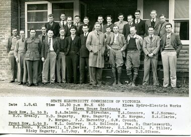
... huts and administrative offices. The facilities necessary for communal living were quickly in place- a post office, police station, co-op store, medical centre, community hall/theatre, tennis courts and school. Much of the temporary accommodation that housed groups such as the Albion Quarrying Company were in the area now under water. This group of photographs are a pictorial record of the early history of the Kiewa Hydro Scheme, the people who worked in the background supplying administrative support and the workers and their families ...Bogong Village, which was known as “The Junction”, is well recorded. The first tent camp was at the junction of Pretty Valley and Rocky Valley streams in the early 40’s. Further downstream were the sawmill, stables and blacksmith’s forge. Horses were the main mode of transport in the early days. The road to Bogong had reached the lookout spur just beyond Roper’s Spur track just before the 1939 fires. The early forties saw rapid growth of the village, with single and married men’s quarters, workshops, mess huts and administrative offices. The facilities necessary for communal living were quickly in place- a post office, police station, co-op store, medical centre, community hall/theatre, tennis courts and school. Much of the temporary accommodation that housed groups such as the Albion Quarrying Company were in the area now under water.This group of photographs are a pictorial record of the early history of the Kiewa Hydro Scheme, the people who worked in the background supplying administrative support and the workers and their families. It also shows a glimpse into how a large group of people from very diverse backgrounds came together to enjoy social activities and share each others companyGroup of 10 black and white photographs and photocopies of original photographs of varying sizes (some official SECV photos) Some Photos are labelled with the date and the names of SECV staff members. Depicting early life at Bogong Village 1. Group photo – Kiewa House Residents 1.8.41 (SECV official photo) 2. Female staff residents 3. Female office staff 4. Kitchen staff – Junction Mess (SECV official photo) 5. Male administration staff Bogong 6. Bogong Social Club fancy dress ball, 1940 7. Wives and children of SECV workers 8. Children in fancy dress 9. Opening of Volunteer Air Observers post 1943 10. Flag raising at opening of Volunteer Air Observers post 1. Printed under photo: STATE ELECTRICITY COMMISSION OF VICTORIA Date: 1.8.41 Time: 12.30pm No:K 435 Kiewa Hydro-Electric Works. Kiewa House Residents Back Row L to R: S.A. Salmon, W. Strachn, T.A Connors, W.J Norman, R.C Grealey, R.D Hegarty, Mrs Hegarty, W.R Morgan, S.A Clarke, P. Morgan, P.J. Harnetty, G.W Crouch. Front Row L to R: W.L Godfrey, R.S Hollands, Pte. R Charlesworth, R.L Dunn, N Caldwell, L.T Davies, I Webber, H.L Kendall, P Tiller, Ricky Hegarty, L.T Guy, M.C Cox, K.F Calder, D.S Gibson 2. Printed on bottom: Staff who lived at Kiewa House and worked in the Administration Office c 1943 Handwritten at bottom Priscilla Johnson (nee Reid) At top of page A GOOD LIFE: WOMEN’S RECOLLECTIONS OF LIFE IN THE UPPER KIEWA VALLEY 3. Printed under photo- Office Staff – Bogong 4. Printed under photo: STATE ELECTRICITY COMMISSION OF VICTORIA Date: 18.5.40 Time: 11.05am No:K 103. Kiewa Hydro-Electric Works. Kitchen Staff- Junction Mess. Opening night of the new staff mess Bogong. 5. Printed under photo -Administration staff Bogong 6. Printed under photo- The social club raised money for patriotic fund from fancy dress nights. (1st Fancy Dress Ball, Bogong 1940) 7. Printed above photo: ---- and family life begins (1942 Bogong) 8. Printed under photo: A favourite photograph 9. Printed under photo: STATE ELECTRICITY COMMISSION OF VICTORIA Date: 24.5.43 Time: 2.8pm No:K 1151 Kiewa Hydro-Electric Works. Bogong- Squadron Leader Leggett speaking at opening of Air Observer’s Post 10. Printed under photo: Raising the flag at the opening of the Volunteer Air Observer’s Post at Bogong - 1943 bogong village; kiewa hydro electric scheme; social activities; community clubs -
 Kiewa Valley Historical Society
Roper's Hut Memorabilia
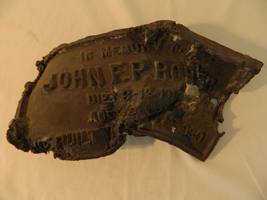
... hut...cattlemen...bogong high plains...bronze plaque...roper family...The burnt plaque and forks and the rebuilding of the huts (Duane's & Roper's) are significant as bush fires are a constant threat to the Bogong High Plains destroying large areas at a time. roper's hut cattlemen bogong high plains bronze plaque roper family bush fires The plaque had 'In Memory of / John F. ...Roper's Hut was built in 1939 and was burnt down in 2003. It was rebuilt in 2008 and is situated on the Bogong High Plains on Duane Spur (where Duane's hut had been before it too was destroyed by (1939) bushfires, between Mt Nelse and Big River. The original hut was used as a shelter for cattlemen who grazed their cattle on the High Plains during summer. The Victorian High Country Huts Association Inc. members and friends helped rebuild the hut which is now used as an emergency shelter for visitors to the High Plains.The memorabilia is significant as the items belonged to the Roper family who were one of the original settlers of the Kiewa Valley and one of the original families who drove their cattle up to the Bogong High Plains. The burnt plaque and forks and the rebuilding of the huts (Duane's & Roper's) are significant as bush fires are a constant threat to the Bogong High Plains destroying large areas at a time.1. Bronze Plaque and 2 damaged forks from Roper's Hut which was destroyed by bush fires in 2003. 2. DVD & USB and hard copy photos of the rebuild of Roper's Hut in January 2008.The plaque had 'In Memory of / John F. P. Roper/ died 3-12-1977 / Aged 78 years / He built the original hut Feb. 1939'roper's hut, cattlemen, bogong high plains, bronze plaque, roper family, bush fires -
 Kiewa Valley Historical Society
Photograph - Folder of Photographs – Photocopied set of black and white photographs (pages 49 -58) from the display folder put together by KVHS to document life on the Kiewa Valley Hydro-electric Scheme
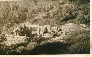
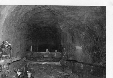
... Large A3 size spiral bound display folder containing photocopied black and white photographs of various aspects of the early days of the Kiewa Valley Hydro-electric scheme including equipment, various work sites and photographs of workers and their families. 1-Workmen working inside one of the tunnels. 2-Workman drilling in West Kiewa Tunnel 3-Junction Dam wall construction 4&5-2B&W photographs Kiewa House residents ready to go to a ball in Mt Beauty 6-Workmen warming up in front of a fire at No 1 bench 7-Workmen being hauled in at No 4 P.S Shaft 8-No 4 Power Station – Drilling 9-Workmen eating a hot meal in the tunnel. 10-2 photographs (a)Pretty Valley camp showing workman’s huts and construction materials & (b)Worker in Langford Gap Basalt Hill Tunnel face 11-Tunnel entrance (unlabelled) with rail tracks in foreground 12- Workmen drilling at No 1 Head race tunnel-Drilling face 13- No 1 Power Station 14-Workmen at the entrance to one of the SECV tunnels under construction ...Page number 51 13&14-No markings Page number 52 Large A3 size spiral bound display folder containing photocopied black and white photographs of various aspects of the early days of the Kiewa Valley Hydro-electric scheme including equipment, various work sites and photographs of workers and their families. 1-Workmen working inside one of the tunnels. 2-Workman drilling in West Kiewa Tunnel 3-Junction Dam wall construction 4&5-2B&W photographs Kiewa House residents ready to go to a ball in Mt Beauty 6-Workmen warming up in front of a fire at No 1 bench 7-Workmen being hauled in at No 4 P.S Shaft 8-No 4 Power Station – Drilling 9-Workmen eating a hot meal in the tunnel. 10-2 photographs (a)Pretty Valley camp showing workman’s huts and construction materials & (b)Worker in Langford Gap Basalt Hill Tunnel face 11-Tunnel entrance (unlabelled) with rail tracks in foreground 12- Workmen drilling at No 1 Head race tunnel-Drilling face 13- No 1 Power Station 14-Workmen at the entrance to one of the SECV tunnels under construction Photograph Folder of Photographs – Photocopied set of black and white photographs (pages 49 -58) from the display folder put together by KVHS to document life on the Kiewa Valley Hydro-electric Scheme ...Although the Kiewa Hydro-Electric Scheme was first proposed in 1911, construction did not commence until 1938. As part of the push to cut electricity costs and diversify supply, the Victorian Government (circa 1930) initiated the conversion from primarily brown coal supply to hydro – electricity. Field investigations during the 1940’s resulted in a new proposal for a scheme that had more than double the capacity of the 1938 scheme. The Kiewa Hydroelectric Scheme became the largest scheme of its kind in the State Of Victoria and the second largest scheme in Australia. The number of personnel involved in the planning and construction of the scheme increased dramatically. During the late 1940’s, most activity centred around the construction of the West Kiewa Power Station, Rocky Valley Reservoir, McKay Creek Power Station and the Bogong Creek Aqueduct.A common thread across all the larger hydro scheme constructions was the need for workers, both qualified and unqualified who came from around the world seeking a new life for themselves and their families. New accommodation and facilities were required for the army of workers engaged in construction in often remote and wild areas. The SEC had a high demand for timber, and set up the first of a number of sawmills at Bogong Creek in 1939 and set up the first hardwood logging in the headwaters of the Kiewa River. These new ‘towns’ such as Mt Beauty and Bogong, survived, serving the needs of operational personnel and their families, and expanding with growth of new industries. Mount Beauty, and to a lesser extent Bogong, are among these places. Large A3 size spiral bound display folder containing photocopied black and white photographs of various aspects of the early days of the Kiewa Valley Hydro-electric scheme including equipment, various work sites and photographs of workers and their families. 1-Workmen working inside one of the tunnels. 2-Workman drilling in West Kiewa Tunnel 3-Junction Dam wall construction 4&5-2B&W photographs Kiewa House residents ready to go to a ball in Mt Beauty 6-Workmen warming up in front of a fire at No 1 bench 7-Workmen being hauled in at No 4 P.S Shaft 8-No 4 Power Station – Drilling 9-Workmen eating a hot meal in the tunnel. 10-2 photographs (a)Pretty Valley camp showing workman’s huts and construction materials & (b)Worker in Langford Gap Basalt Hill Tunnel face 11-Tunnel entrance (unlabelled) with rail tracks in foreground 12- Workmen drilling at No 1 Head race tunnel-Drilling face 13- No 1 Power Station 14-Workmen at the entrance to one of the SECV tunnels under construction 1-SECV number at bottom of picture Half obscured possibly K8461 Page number 53 2-In West Kiewa Tunnel Page number 54 3- Construction of Junction Dam wall – approximately 1941 Page number 55 4&5- Residents of Kiewa House at Bogong ready to go to the ball at Mt Beauty-1946. Handwritten on a copy of the photo on opposite page Mrs Lorna Crosset filled out the names *Dad was Des Crossett – his daughter is Gael Petcopoulis Greta engaged to John broke it off. Charlie, Rosalind, Bill, Priscilla, Max Lawrence-Dad’s Boss, Mary & Max married, Mary, Kay, Gwen McPherson Mum’s boss, John McCluskey (c) At No. 5 Bench Page number 56 6- STATE ELECTRICITY COMMISSION OF VICTORIA Date: 27.2.51 Time:2.15pm No K6373 Kiewa Hydro Electric Works No. 4 P.S. Shaft – Haulage of men in buckets (b) As above Handwritten at top of photo Appendix 4 page number 57 7- STATE ELECTRICITY COMMISSION OF VICTORIA Date: 6.6.52 Time:… No K7122 Kiewa Hydro Electric Works No. 4 POWER STATION – DRILLING page number 58 8-No markings page number 59 9-(a)Handwritten under photograph Approx. 1948/49 (b) STATE ELECTRICITY COMMISSION OF VICTORIA Date: 28.10.54 Time:.. No K7860 Kiewa Hydro Electric Works LANGFORD GAP BASALT HILL TUNNEL FACE Page number 49 10-(a) No markings 11- STATE ELECTRICITY COMMISSION OF VICTORIA Date: 20.3.52 Time: No K6979 Kiewa Hydro Electric Works No. 1 HEAD RACE TUNNEL – DRILLING FACE (E.E.E. CONTRACT) ‘The Frenchies’ (E.E.E) as they were affectionately known Page number 50 12-31.5.56 No. 1 Power Station Aggregate Stock Piles. Page number 51 13&14-No markings Page number 52 secv; kiewa hydro electric scheme; bogong; mt beauty; construction area -
 Kiewa Valley Historical Society
Photograph – black and white photograph of children playing in the school yard at Bogong Village Primary School, Circa late 1960s to early 1970’s
... huts and administrative offices. The facilities necessary for communal living were quickly in place- a post office, police station, co-op store, medical centre, community hall/theatre, tennis courts and school. Bogong Primary School opened in 1941 to provide an education for the families...huts and administrative offices. The facilities necessary for communal living were quickly in place- a post office, police station, co-op store, medical centre, community hall/theatre, tennis courts and school. Bogong Primary School opened in 1941 to provide an education for the families ...The early forties saw rapid growth of Bogong Village, with single and married men’s quarters, workshops, mess huts and administrative offices. The facilities necessary for communal living were quickly in place- a post office, police station, co-op store, medical centre, community hall/theatre, tennis courts and school. Bogong Primary School opened in 1941 to provide an education for the families of employees of the State Electricity Commission of Victoria. The school had up to date equipment and received glowing reports from school inspectors. It closed circa 1970.The Bogong State School was opened for the children of S.E.C.V. workers who lived in Bogong in a remote part of north east Victoria. The nearest school would have been 14 miles away and over mountain roads subject to heavy construction traffic and extremes of climatic conditionsBlack and white photograph of a group of 6 children playing on play equipment in the schoolyard at Bogong Primary School. The area is enclosed by tall trees in a bush-like settingbogong state school; secv; kiewa hydro electric scheme; -
 Kiewa Valley Historical Society
Photos - Collection Wallaces Hut Restoration and one of Cope Hut
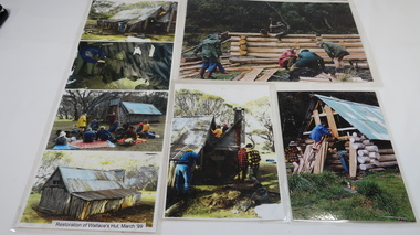
... Kiewa Valley Historical Society Mount Beauty Information Centre 31 Bogong High Plains Rd Mt Beauty high-country Wallace's Hut, the oldest hut on the Bogong High Plains, was restored in march 1999 Cattlemen's Huts belonged to farming families of the Kiewa Valley. They used the huts when staying with their cattle on the High Plains during summer. wallace's hut bogong high plains All have velcro tape on the back in the corners 7 coloured photos laminated depicting restoration of Wallace's Hut. ...Wallace's Hut, the oldest hut on the Bogong High Plains, was restored in march 1999Cattlemen's Huts belonged to farming families of the Kiewa Valley. They used the huts when staying with their cattle on the High Plains during summer.7 coloured photos laminated depicting restoration of Wallace's Hut. March 1999 and 1 larger photo of Cope Hut (on hill) 1 larger photo, 2 medium sized photos and the 4 smaller photos laminated together.All have velcro tape on the back in the cornerswallace's hut, bogong high plains -
 Kiewa Valley Historical Society
Dress, c1950
... The Roper Family is one of the pioneering farming families of the Kiewa Valley. They built and used Ropers Hut on the High Plains. ...Mrs Clare Roper wore this dress to a garden party at Buckingham Palace when she was invited there to represent the Lions Club.The Roper Family is one of the pioneering farming families of the Kiewa Valley. They built and used Ropers Hut on the High Plains. The dress worn by Clare Roper has historical significance as it represents the importance of the CWA which Claire Roper was involved with as President thus being invited to Buckingham Palace. The dress also shows the fashions of the time and indicates ladies living in the small country towns still viewed fashion as important. Since we know it was Clare Ropers dress it is well provenances, is in reasonable condition and has very good interpretive capacity. This brown shirt waister dress has an 'A' line skirt with an inverted pleat on the lower half of both the front and back. The dress has a 'Peter Pan' collar, matching belt, pockets and short sleeves. There are 3 bound button holes and buttons, gold set with pearls, only one is complete. The front top, cuffs and pockets are embroidered with cream lace. There is a press stud and hook at the neck. There is also a side zip opening in the skirt.kiewa, farming; ropers hut; lions club; clothing; clothes; dress; clare roper; high plains; buckingham palace; -
 Kiewa Valley Historical Society
Folder - Cattlemen Families, Cattlemen of the High Plains
... The Ryder and Edmondson families lived in the Kiewa Valley and had grazing licenses and huts on the Bogong High Plains....Kiewa Valley Historical Society Mount Beauty Information Centre 31 Bogong High Plains Rd Mt Beauty high-country The Ryder and Edmondson families lived in the Kiewa Valley and had grazing licenses and huts on the Bogong High Plains. ...The Ryder and Edmondson families lived in the Kiewa Valley and had grazing licenses and huts on the Bogong High Plains.Pioneer families of the Kiewa Valley and Cattlemen of the Bogong High Plains.Plastic red folder with transparent front held by 2 gold metal slide clips. 16 clear plastic sheets holding 17 pages of photocopied print and pictures, 1 family tree, 1 photocopied photo, 1 birth document, 1 printed page, 3 photocopied letters and 7 printed pages. ryder family; edmondson family; kiewa valley -
 Kiewa Valley Historical Society
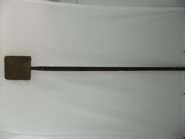
Spade - Long handled
... Wallace's Hut is the oldest cattleman's hut and was owned by the Wallace family....Wallace's Hut is the oldest cattleman's hut and was owned by the Wallace family. This long handled spade was used by the 3 Wallace Brothers to dig 6 post holes for the posts of Wallace's Hut in 1889. ...The cattlemen's huts on the High Plains were used as shelter during the herding of the cattle on the Bogong High Plains during summer. Wallace's Hut is the oldest cattleman's hut and was owned by the Wallace family.This long handled spade was used by the 3 Wallace Brothers to dig 6 post holes for the posts of Wallace's Hut in 1889. On the 6th hole they struck rock 6 inches down but they persevered and succeeded in chipping away the rock to the required depth of 3 feet. This is the post in the south east corner.This long handled spade was made in Birmingham and was used by the 3 Wallace Brothers to dig 6 postholes for Wallace's Hut on the bogong high Plains in 1889.Birmingham 3 Cast Steel 234bogong high plains. wallace's hut. cattlemen's huts. tool. -
 Kiewa Valley Historical Society
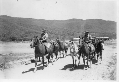
Photo - Pack horses leaving Mt Beauty
... Farmers from the Kiewa Valley drove their cattle up to the Bogong High Plains during summer. Each family had a lease and a hut to stay in. Pack horses were used to carry food and other necessary items for the men while they were away....Kiewa Valley Historical Society Mount Beauty Information Centre 31 Bogong High Plains Rd Mt Beauty high-country Farmers from the Kiewa Valley drove their cattle up to the Bogong High Plains during summer. Each family had a lease and a hut to stay in. Pack horses were used to carry food and other necessary items for the men while they were away. ...Farmers from the Kiewa Valley drove their cattle up to the Bogong High Plains during summer. Each family had a lease and a hut to stay in. Pack horses were used to carry food and other necessary items for the men while they were away.The Ryder family farmed in the Kiewa Valley and had a grazing lease and hut on the Bogong High Plains where they droe their cattle during summer. Black and white photo with 2 men on horses each followed by two packhorses. Wally Ryder is on the horseman on the right. January 1947. This photo is published on page 114 of 'A History of the Kiewa Valley' by Esther Temple and David Lloyd.On back 'Pack horses leaving Mt Beauty / January 1947 / Suspect Wally Ryder on right.'wally ryder, cattlemen, packhorses