Showing 14 items matching "flat rock road"
-
 Eltham District Historical Society Inc
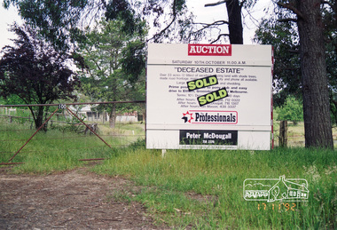
Photograph, Real Estate Auction Sale: 100 Flat Rock Road, Kangaroo Ground, 17 November 1992, 1992
... Real Estate Auction Sale: 100 Flat Rock Road, Kangaroo Ground, 17 November 1992...flat rock road, houses, ian mason, kangaroo ground, kangaroo ground pony club, peter mcdougall real estate, real estate agent, tony mcdougall...It was one of the first sales that Ian was involved with in his career, starting out at Peter McDougall Real Estate. flat rock road, houses, ian mason, kangaroo ground, kangaroo ground pony club, peter mcdougall real estate, real estate agent, tony mcdougall Fuji 100 Roll of 35mm colour negative film, 4 strips Real Estate Auction Sale: 100 Flat Rock Road, Kangaroo Ground, 17 November 1992 Photograph ...Deceased estate sold by Peter McDougall of The Professionals; 23 acres in size on 2 titles in a prime position, with a made road frontage and close to the Pony Club with an easy drive to Eltham, Greensborough and Melbourne. Ian Mason of Mason White McDougall Real Estate advised (via Facebook) that two local builders battled it out at the auction run by Tony McDougall and that there are houses now on both titles. It was one of the first sales that Ian was involved with in his career, starting out at Peter McDougall Real Estate.Roll of 35mm colour negative film, 4 strips Fuji 100flat rock road, houses, ian mason, kangaroo ground, kangaroo ground pony club, peter mcdougall real estate, real estate agent, tony mcdougall -
 Eltham District Historical Society Inc
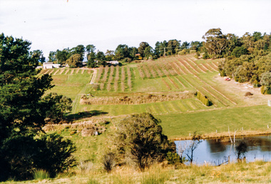
Photograph, Between Kangaroo Ground and Panton Hill looking east from near Flat Rock Road towards Kangaroo Ground-St Andrews Road, 1995, 1995
... Between Kangaroo Ground and Panton Hill looking east from near Flat Rock Road towards Kangaroo Ground-St Andrews Road, 1995...Flat Rock Road...Eltham District Historical Society Inc 728 Main Rd Eltham melbourne Flat Rock Road Kangaroo Ground Kangaroo Ground-St Andrews Road Colour photograph Between Kangaroo Ground and Panton Hill looking east from near Flat Rock Road towards Kangaroo Ground-St Andrews Road, 1995 Photograph ...Colour photographflat rock road, kangaroo ground, kangaroo ground-st andrews road -
 Eltham District Historical Society Inc
Negative - Photograph, J.A. McDonald, Heidelberg-Kinglake Road, Mar. 1960
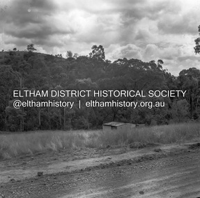
... ...Flat Rock Road...Cherry Tree Road Job 56F443 Contractors Wolf and Wood Junction of Cherry Tree and Flat Rock Roads – old alignment Looking along new alignment March 1960...Eltham District Historical Society Inc 728 Main Rd Eltham melbourne Cherry Tree Road Job 56F443 Contractors Wolf and Wood Junction of Cherry Tree and Flat Rock Roads – old alignment Looking along new alignment March 1960 Record of various Shire of Eltham infrastructure works undertaken during the period of 1952-1962 involving bridge and road reconstruction projects, sometimes with Eltham Shire Council Project Reference numbers quoted. ...Cherry Tree Road Job 56F443 Contractors Wolf and Wood Junction of Cherry Tree and Flat Rock Roads – old alignment Looking along new alignment March 1960Record of various Shire of Eltham infrastructure works undertaken during the period of 1952-1962 involving bridge and road reconstruction projects, sometimes with Eltham Shire Council Project Reference numbers quoted. It was during this period that a number of significant improvements were made to roads and new bridges constructed within the shire that remain in place as of present day (2022). In many situations, the photos provide a tangible visible record of infrastructure that existed throughout the early days of the Shire. The album was put together by or under the direction of the Shire Engineer, J.A. McDonald.infrastructure, 1960-03, bridge construction, cherry tree road, heidelberg-kinglake road, road construction, shire of eltham, flat rock road -
 Eltham District Historical Society Inc
Negative - Photograph, J.A. McDonald, Road Reserve Housing, Mar. 1961
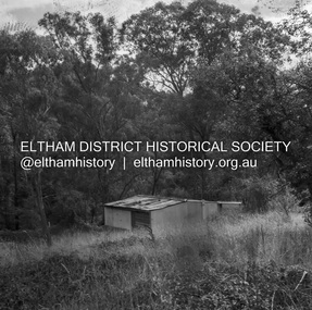
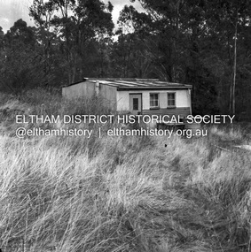
... ...Flat Rock Road...Shack built on road reserve without permit Most probably up on Simms Road, Kinglake Other areas where illegal shacks were built wer at the junction of Flat Rock Road and Cherry Tree Road, Hurstbridge. ...Eltham District Historical Society Inc 728 Main Rd Eltham melbourne Shack built on road reserve without permit Most probably up on Simms Road, Kinglake Other areas where illegal shacks were built wer at the junction of Flat Rock Road and Cherry Tree Road, Hurstbridge. ...Shack built on road reserve without permit Most probably up on Simms Road, Kinglake Other areas where illegal shacks were built wer at the junction of Flat Rock Road and Cherry Tree Road, Hurstbridge. At times, Building Surveyor George E Newton would have to attend to these shacks for inspection and issue demolition ordersRecord of various Shire of Eltham infrastructure works undertaken during the period of 1952-1962 involving bridge and road reconstruction projects, sometimes with Eltham Shire Council Project Reference numbers quoted. It was during this period that a number of significant improvements were made to roads and new bridges constructed within the shire that remain in place as of present day (2022). In many situations, the photos provide a tangible visible record of infrastructure that existed throughout the early days of the Shire. The album was put together by or under the direction of the Shire Engineer, J.A. McDonald.infrastructure, shire of eltham, 1961-03, building surveyor, cherry tree road, flat rock road, george e. newton, houses, hurstbridge, kinglake, road reserve, road reserve housing, scan - 120 format 6x6 negative, shack, simms road -
 Eltham District Historical Society Inc
Negative - Photograph, J.A. McDonald, Road Reserve Housing, Mar. 1961
... ...Flat Rock Road...Shack built on road reserve without permit Most probably up on Simms Road, Kinglake Other areas where illegal shacks were built were at the junction of Flat Rock Road and Cherry Tree Road, Hurstbridge. ...Eltham District Historical Society Inc 728 Main Rd Eltham melbourne Shack built on road reserve without permit Most probably up on Simms Road, Kinglake Other areas where illegal shacks were built were at the junction of Flat Rock Road and Cherry Tree Road, Hurstbridge. ...Shack built on road reserve without permit Most probably up on Simms Road, Kinglake Other areas where illegal shacks were built were at the junction of Flat Rock Road and Cherry Tree Road, Hurstbridge. At times, Building Surveyor George E Newton would have to attend to these shacks for inspection and issue demolition ordersRecord of various Shire of Eltham infrastructure works undertaken during the period of 1952-1962 involving bridge and road reconstruction projects, sometimes with Eltham Shire Council Project Reference numbers quoted. It was during this period that a number of significant improvements were made to roads and new bridges constructed within the shire that remain in place as of present day (2022). In many situations, the photos provide a tangible visible record of infrastructure that existed throughout the early days of the Shire. The album was put together by or under the direction of the Shire Engineer, J.A. McDonald.infrastructure, shire of eltham, 1961-03, building surveyor, cherry tree road, flat rock road, george e. newton, houses, hurstbridge, kinglake, road reserve, road reserve housing, scan - 120 format 6x6 negative, shack, simms road -
 Eltham District Historical Society Inc
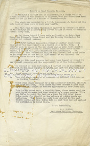
Document - Report, G.E. Newton, Road Reserve Housing, Aug. 1957
... ...Flat Rock Road...Shack built on road reserve without permit Most probably up on Simms Road, Kinglake Other areas where illegal shacks were built were at the junction of Flat Rock Road and Cherry Tree Road, Hurstbridge. ...Eltham District Historical Society Inc 728 Main Rd Eltham melbourne Shack built on road reserve without permit Most probably up on Simms Road, Kinglake Other areas where illegal shacks were built were at the junction of Flat Rock Road and Cherry Tree Road, Hurstbridge. ...Shack built on road reserve without permit Most probably up on Simms Road, Kinglake Other areas where illegal shacks were built were at the junction of Flat Rock Road and Cherry Tree Road, Hurstbridge. At times, Building Surveyor George E Newton would have to attend to these shacks for inspection and issue demolition orders Related to photos: EDHS_05580-1/2/3Record of various Shire of Eltham infrastructure works undertaken during the period of 1952-1962 involving bridge and road reconstruction projects, sometimes with Eltham Shire Council Project Reference numbers quoted. It was during this period that a number of significant improvements were made to roads and new bridges constructed within the shire that remain in place as of present day (2022). In many situations, the photos provide a tangible visible record of infrastructure that existed throughout the early days of the Shire. The album was put together by or under the direction of the Shire Engineer, J.A. McDonald.infrastructure, shire of eltham, building surveyor, cherry tree road, flat rock road, george e. newton, houses, hurstbridge, road reserve, road reserve housing, shack -
 Eltham District Historical Society Inc
Album - Photograph Album, J.A. McDonald, Bridge and Road Reconstruction Works, Shire of Eltham, 1952-1962
... ...Flat Rock Road...Wood Fitzsimons Lane Bridge Flat Rock Road Flood damage floods Floodwater Footpaths and gutters Ford Service Garage G. ...J.A. McDonald produced this record in the course of his responsibilities as Shire Engineer for Eltham Shire Council.Record of various Shire of Eltham infrastructure works undertaken during the period of 1952-1962 involving bridge and road reconstruction projects, sometimes with Eltham Shire Council Project Reference numbers quoted. It was during this period that a number of significant improvements were made to roads and new bridges constructed within the shire that remain in place as of present day (2022). In many situations, the photos provide a tangible visible record of infrastructure that existed throughout the early days of the Shire. The album was put together by or under the direction of the Shire Engineer, J.A. McDonald.a. gillies, alistair knox park, benchmark studies, bend of islands, blease road, box hill state school, box hill teachers college, box hill tip, bridge construction, bridge street bridge, bridge, brisbane street, brougham steet, bulldozer, cecil street, charis pelling, cherry tree road, city of preston, cr. a. brinkkotter, cr. charis pelling, cranes, cromwell street, diamond creek (creek), diamond street, dixons creek bridge, dixon's creek road, drott, eltham leisure centre, eltham north, eltham police station, eltham, eltham-yarra glen road, f. wood, fitzsimons lane bridge, flat rock road, flood damage, floods, floodwater, footpaths and gutters, ford service garage, g. blair, garden hill, glen park bridge, glenauburn road, grand hotel, haldane road, healesville, healesville-yarra glen road, heidelberg-kinglake road, henley road bridge, henley road, hill property, hurstbridge water scheme, hurstbridge, hurstbridge-arthurs creek road, infrastructure, j. jolly, kangaroo ground, kangaroo ground-queenstown road, kangaroo ground-st andrews road, lilydale shire office, long gully bridge, long gully creek, long gully road, long gully, lower plenty bridge, lower plenty footbridge, lower plenty oval, lower plenty road, lower plenty, main road, methodist church, montmorency, mount pleasant road, new holland, old healesville road, opening ceremony, oxley bridge, para road, paul creek bridge, paul creek road, paul krafeznk, pinnacle lane, plaques, plenty river trail, plenty river, presbyterian church, prof donald thomson, pryor street, railway crossing, railway parade, rattray road, reconstruction works, reichelt avenue, research (vic.), research oval, road construction, rymers corner, shire of eltham, shire of whittlesea, silvan road bridge, silver street bridge, silver street, sir dallas brooks, smedley property, st andrews, steels creek, susan street, tarrawarra, tony carberry, uniting church, upper yarra dam, upper yarra reservoir, w.e. wolf, waterfall property, watsons creek, wattletree road bridge, wattletree road, wattletree road bridge, worlingworth, yarra glen, york street, yow yow creek -
 Greensborough Historical Society
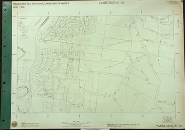
Map, Melbourne and Metropolitan Board of Works. Survey Division, MMBW, Yarra 2500 / 17.26. Hurstbridge, 1978_01
... Prominent streets include: Flat Rock Road and Heather Avenue. Includes Hurstbridge Railway Station....Prominent streets include: Flat Rock Road and Heather Avenue. Includes Hurstbridge Railway Station. mmbw melbourne and metropolitan board of works shire of diamond valley hurstbridge - maps MMBW Map in 1:2500 [scale] series. ...Melbourne and Metropolitan Board of Works. Yarra 2500 [base map] 17-26. Hurstbridge. Municipalities of Diamond Valley 257 and Eltham 238. Prominent streets include: Flat Rock Road and Heather Avenue. Includes Hurstbridge Railway Station.MMBW Map in 1:2500 [scale] series. Cream parchment with green tape reinforcing on edges and punched holes on left edge.mmbw, melbourne and metropolitan board of works, shire of diamond valley, hurstbridge - maps -
 Halls Gap & Grampians Historical Society
Postcard - B/W, C 1920s
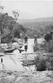
... Halls Gap & Grampians Historical Society Centennial Hall 117-119 Grampians Road Halls Gap grampians SCENERY PEOPLE Post Card, Correspondence, Address only, Kodak, Australia Postcard shows 3 women, 1 seated, 2 standing on flat rock around water pools Area unknown Postcard B/W ...Postcard shows 3 women, 1 seated, 2 standing on flat rock around water pools Area unknownPost Card, Correspondence, Address only, Kodak, Australiascenery, people -
 Eltham District Historical Society Inc
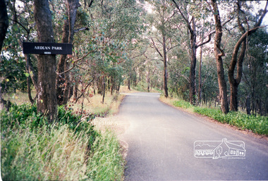
Photograph, Ardean Park, 315 Flat Rock Rd, Hurstbridge
... 8i6656 shire of eltham roads flatrock road hurstbridge ardean park cowan Kodak GA 100 5095 Roll of 35mm colour negative film, 2 strips Ardean Park, 315 Flat Rock Rd, Hurstbridge Photograph ...Sold by Fletchers 3 Dec 2015 for $1.26m. See https://www.realestate.com.au/sold/property-house-vic-hurstbridge-121193850 Google Streetview Feb 2014 https://www.google.com.au/maps/@-37.6455525,145.2071828,3a,49.4y,333.82h,88.64t/data=!3m6!1e1!3m4!1sr2PfMo3UeXV_fqSDYToiuA!2e0!7i13312!8i6656Roll of 35mm colour negative film, 2 stripsKodak GA 100 5095shire of eltham, roads, flatrock road, hurstbridge, ardean park, cowan -
 Bendigo Historical Society Inc.
Postcard - Alice McGregor Postcard Collection, 1900 - 1920
... Flat Cemetery See additional research. Postcard Album of Alice McGregor contained 86 post cards. POSTCARD Collector Alice McGregor Addressed to Mrs Shatford, The Anchorage, Beach Road, Black Rock Sender A C, Postage stamp dated 31.12.06 Postcard Album of Alice McGregor containing 86 post cards. ...Alice McGREGOR Born: 1908; unknown parents. Possibly adopted by the Salter family? Electoral Roll 1936: Highland Terrace Kangaroo Flat. Alice Mary Salter and William Robert Salter living together; presumed to be sister and brother. William Robert Salter was killed in a MVA in Bendigo in 1937 aged 26. In Victoria in 1938, Alice Mary Salter married James Thomas McGregor (born Victoria 1917, died Victoria 1983, buried Fawkner Cemetery) Lived: 1968; 22 Wade Street Golden Square Alice McGregor Died: 1999 aged 91 at Anne Caudle Centre, Bendigo Buried: Kangaroo Flat Cemetery See additional research. Postcard Album of Alice McGregor contained 86 post cards.Postcard Album of Alice McGregor containing 86 post cards. See 1400. B&W photo of a young girl dressed in white holding a small branch of a tree. In a studio forest setting. Addressed to Mrs Shatford, The Anchorage, Beach Road, Black Rock Sender A C, Postage stamp dated 31.12.06 postcard, collector, alice mcgregor -
 Bendigo Historical Society Inc.
Postcard - Alice McGregor Postcard Collection, 1900 - 1920
... Flat Cemetery See additional research. Postcard Album of Alice McGregor contained 86 post cards. POSTCARD Collector Alice McGregor Addressed to Mrs Shatford, The Anchorage, Beach Road, Black Rock Sender Miss L. ...Alice McGREGOR Born: 1908; unknown parents. Possibly adopted by the Salter family? Electoral Roll 1936: Highland Terrace Kangaroo Flat. Alice Mary Salter and William Robert Salter living together; presumed to be sister and brother. William Robert Salter was killed in a MVA in Bendigo in 1937 aged 26. In Victoria in 1938, Alice Mary Salter married James Thomas McGregor (born Victoria 1917, died Victoria 1983, buried Fawkner Cemetery) Lived: 1968; 22 Wade Street Golden Square Alice McGregor Died: 1999 aged 91 at Anne Caudle Centre, Bendigo Buried: Kangaroo Flat Cemetery See additional research. Postcard Album of Alice McGregor contained 86 post cards.Postcard Album of Alice McGregor containing 86 post cards. See 1400. Colour painting of 'The Shambles, York.' Addressed to Mrs Shatford, The Anchorage, Beach Road, Black Rock Sender Miss L. Kirkpatrick, Hulford End, Chelmsford, Essex, England Dated 5.7.05 postcard, collector, alice mcgregor -
 City of Moorabbin Historical Society (Operating the Box Cottage Museum)
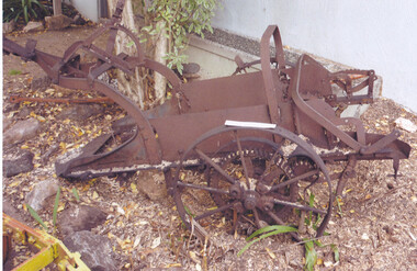
Tool - Farm Machinery, Horse-drawn Plough Potato Digger, c1900
... City of Moorabbin Historical Society (Operating the Box Cottage Museum) Joyce Park Jasper Road Ormond melbourne Circa late 1800s early 1900s a horse-drawn plough, potato digger, is one example of the implements that were widely used by early market gardeners in the Shire of Moorabbin. The flat plate, seen to the right of the photo, dug down into the ground below the potatoes and "scooped" them up. Behind the plate, two driving chains on cogs, (these chains are missing from our exhibit), then "rocked ...Circa late 1800s early 1900s a horse-drawn plough, potato digger, is one example of the implements that were widely used by early market gardeners in the Shire of Moorabbin. The flat plate, seen to the right of the photo, dug down into the ground below the potatoes and "scooped" them up. Behind the plate, two driving chains on cogs, (these chains are missing from our exhibit), then "rocked' the dug potatoes to loosen the soil from the "spuds". The potatoes were then harvested by hand. Very large tracts of land in the Shire of Moorabbin were planted with potatoes. Harvesting commenced in October, into November and on into December. Potatoes were a necessary food staple. The market gardeners were always in a rush to be first to get their potatoes to market, and hence the best price. Some market gardeners were so keen to be the first to market, (and get the most money), that they dug their potatoes "green" (or new). The only downside of this practice was that these early potatoes had to be handled with extreme care as their skins were very loose, and came off easily - so decreasing their profits.As well as taking their produce to the Melbourne and St Kilda markets, they also sent produce off to Sydney markets. It is interesting to note that a group of Chinese market gardeners were the first to access the Sydney market. .Following the 'Dendy's Special Survey' 1841 and the Crown Land Sale of 1852, land allotments were sold to pioneer settlers who established market gardens in the area of Moorabbin Shire. During the 1850s gold-rush population boom the number of market gardeners increased significantly spreading throughout the Moorabbin Shire. Potatoes were considered a staple foodstuff, so crops were regularly sown throughout the whole Moorabbin area. Circa late 1800s early 1900s. A horse-drawn plough potato digger is an example of the machines used by early market gardeners in Moorabbin Shiremelbourne, sydney, markets, vegetables, potato, dendy henry, st kilda, market gardeners, gold rush, moorabin, chinese gardeners, ploughs