Showing 55 items matching "flooding of mine"
-
 Bendigo Historical Society Inc.
Document - The Flooded Mine, John McCaviston's Escape, April, 2014
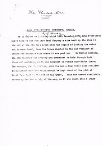
... ...flooding of mine...Copy of handwritten document. 'The Flooded Mine, John McCaviston's Wonderful Escape' by G. ...Great Extended Hustlers goldmining accident quartz mining flooding of mine John McCaviston mine rescue R. jackson Latham and Watson 3527.2 on bottom of all pages. ...Seven men were killed at the Great Extended Hustler's mine disaster on 2nd May 1914 by an explosion of dynamite occurring as the men were waiting at the plat to ascend the mine at the end of their shift. No blame was attached to anyone in the findings of the inquisition. It was unknown what caused the dynamite to explode. Three page typed document by Albert Richardson. Copy of handwritten document. 'The Flooded Mine, John McCaviston's Wonderful Escape' by G. Mackay (History of Bendigo). Article details the events that surrounded the flooding that occurred at the Hustlers Reef Company's mine on 13th December 1873. Water was being drained from the adjoining old workings of Latham and Watson, when the flow increased markedly, causing flooding. John McCaviston was the 'shift boss'., R. Jackson the Manager. McCaviston was saved after spending over 20 hours in a level.3527.2 on bottom of all pages. Duplicate copy. great extended hustlers, goldmining, accident, quartz, mining, flooding of mine, john mccaviston, mine rescue, r. jackson, latham and watson -
 Bendigo Historical Society Inc.
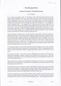
Photograph - TAMBOUR MAJOR MINE - PHOTO OF DIVER
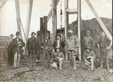
... Photocopy of a photo of a diver and nine men outside the mine. The diver was inspecting the flooded Tambour Major Mine at Specimen Hill in 1920. ...History House 11 Mackenzie Street Bendigo goldfields PHOTO Group male Tambour Major Mine Photo of diver Photocopy of a photo of a diver and nine men outside the mine. The diver was inspecting the flooded Tambour Major Mine at Specimen Hill in 1920. ...Photocopy of a photo of a diver and nine men outside the mine. The diver was inspecting the flooded Tambour Major Mine at Specimen Hill in 1920. Photo taken by Percival ?, Bendigo.photo, group, male, tambour major mine, photo of diver -
 Unions Ballarat
The cardigan mine disaster (Don Woodward Collection), Atkinson, Jeffrey, 2002
... An account of the flooding of the Cardigan mine (near Ballarat) in 1902. ...Unions Ballarat 24 Camp Street Ballarat goldfields An account of the flooding of the Cardigan mine (near Ballarat) in 1902. ...An account of the flooding of the Cardigan mine (near Ballarat) in 1902. Four men died and five were rescued from the mine.Workplace safety and Ballarat historical relevance.Book; 58 pages. Front cover: light green background; dark green graphic of the mine; black lettering; author's name and title.Title page: price - $18.50 - in pencil.btlc, ballarat trades hall, ballarat trades and labour council, occupational health and safety, cardigan mine, gold mining - ballarat -
 Bendigo Historical Society Inc.
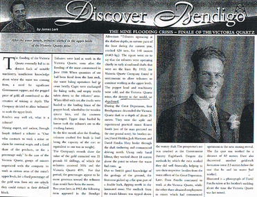
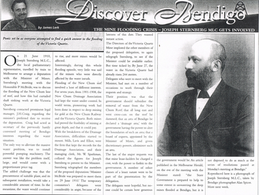
Document - LONG GULLY HISTORY GROUP COLLECTION: THE MINE FLOODING CRISIS - FINALE OF THE VICTORIA QUARTZ
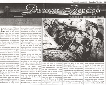
... Soon after the flooding of the mine commenced in June 1910, tributers worked the upper levels. ...Soon after the flooding of the mine commenced in June 1910, tributers worked the upper levels. ...BHS CollectionPhotocopy of a newspaper article titled Discover Bendigo by James Lerk titled The Mine Flooding Crisis - Finale of the Victoria Quartz. Soon after the flooding of the mine commenced in June 1910, tributers worked the upper levels. By 1913 the Company found it was uneconomic to allow tributers to continue working in the upper levels. Four Bendigo men, Ernest Smith, David Holden, Jack Harrison and David Patullo worked the mine during the Depression. They did well. A photo of David Patullo is in the article.bendigo, history, long gully history group, the long gully history group - the mine flooding crisis - finale of the victoria quartz, james lerk, victria quartz, brough smyth, bendigo advertiser 1912, great depression, ernest smith, david holden, jack harrison, david patullo, government battery eaglehawk -
 Clunes Museum
Photograph, PORT PHILLIP MINE
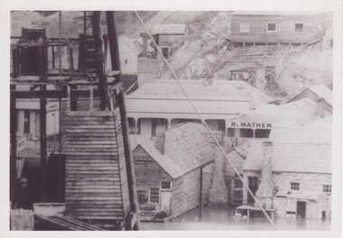
... BLACK AND WHITE PHOTOGRAPH - SECTION PORT PHILLIP MINE. FLOOD WATER SURROUNDING BASE OF BUILDINGS R. ...Clunes Museum 36 Fraser Street enter building through Collins Place Clunes goldfields photographs mining PORT PHILLIP MINE BLACK AND WHITE PHOTOGRAPH - SECTION PORT PHILLIP MINE. FLOOD WATER SURROUNDING BASE OF BUILDINGS R. ...BLACK AND WHITE PHOTOGRAPH - SECTION PORT PHILLIP MINE. FLOOD WATER SURROUNDING BASE OF BUILDINGS R. MATHER BUILDING VISIBLEphotographs, mining, port phillip mine -
 Bendigo Historical Society Inc.
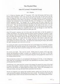
Document - TYPEWRITTEN ACCOUNT OF JOH MCCAVISTON'S WONDERFUL ESCAPE FROM THE HUSTLERS REEF MINE, 1873
... No date on this document; handwritten on front page is ''The Flooded Mine'' ''By G Mackay'' (Occasional handwritten notations to text)...Detailed story of shift boss, M'Caviston who descended into the flooding mine to warn workers below (who had actually left somewhat before) and who was himself trapped. ...Typewritten 10-page account of ''John McCaviston's Wonderful Escape'' (from the Hustlers Reef mine, 1873). Detailed story of shift boss, M'Caviston who descended into the flooding mine to warn workers below (who had actually left somewhat before) and who was himself trapped. The water in the shaft rose to a much higher level but M'Caviston was saved by being able to take refuge in a drive that had a 'stulling' (a mound of stones under a raised portion of the drive - allowing for an amount of trapped air). The account concludes as follows: ''The preservation of his life was discussed from a scientific point of view, and diverse opinions were expressed, and doubts (sic)'' (there is no page 11). No date on this document; handwritten on front page is ''The Flooded Mine'' ''By G Mackay'' (Occasional handwritten notations to text)document, names of bendigo pioneers, bendigo goldfields -
 Bendigo Historical Society Inc.
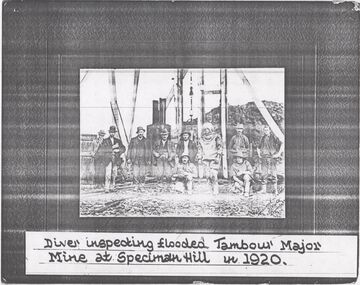
Photograph - TAMBOUR MAJOR MINE AT SPECIMEN HILL, 1920
... Mine Manager in diving suit. A Richardson, 29 Harrison Street' Hand printed in black ink on back 'Diver inspecting flooded Tambour Major Mine in 1920'. ...Mine Manager in diving suit. A Richardson, 29 Harrison Street' Hand printed in black ink on back 'Diver inspecting flooded Tambour Major Mine in 1920'. ...Black and white photograph mounted on brown board. Ten males in front of mine shaft. One male in divers suit. Male second from L holding small dog. Cage and poppet legs in background. Mullock heap at back. Inscriptions: Hand written on BR corner of photo 'Percival Pinder, Photo, Bendigo' Hand written on board under photo 'Tambour Major GM Coy 846 ft'. On separate card glued to bottom of mount board, printed 'Diver inspecting flooded Tambour Major Mine at Specimen Hill in 1920'. Hand written in ball point pen on back 'Tambour Major' Mine Group photo taken at Tambour Major about 1920. Dad on extreme right, Joe Sheard, Mine Manager in diving suit. A Richardson, 29 Harrison Street' Hand printed in black ink on back 'Diver inspecting flooded Tambour Major Mine in 1920'. On back - circular purple stamp 'Royal Historical Society of Victoria, Bendigo Branch'.Percival Pinder, Bendigomining, surface equipment, tambour major mine, bendigo, mines and mining, miners, mine, specimen hill, flooded mine, diver -
 Bendigo Historical Society Inc.
Newspaper - LONG GULLY HISTORY GROUP COLLECTION: FLOODING OF THE VICTORIA QUARTZ
... Article mentions the flooding of the mine, the equipment left in there and where the water had come from. ...Article mentions the flooding of the mine, the equipment left in there and where the water had come from. ...Copy of an article from the Bendigo Weekly 19/5/2000 Discover Bendigo - Flooding of the Victoria Quartz by James Lerk. Article mentions the flooding of the mine, the equipment left in there and where the water had come from. An accompanying photo, taken by Vincent Kelly, shows miners at work underground. John Ennor, the mine manager at the time and William Abraham, the Mining Inspector are in the photo. Written on the photo is: 4156 ft below Vic Quartz G Mine. bendigo, history, long gully history group, the long gully history group - flooding of the victoria quartz, bendigo weekly 19/5/2000, james lerk, william abraham, matthew stevens, 180 mine, new chum and victoria, new chum railway, new shenandoah, new chum reef, south bellevue, nell gwynne reef, new chum drainage association, bendigo advertiser, vincent kelly, john ennor -
 Bendigo Historical Society Inc.
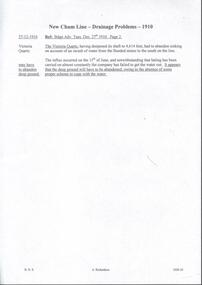
Document - DRAINAGE PROBLEMS - NEW CHUM LINE DRAINAGE PROBLEMS 1910
... ''The Victoria Quartz, having deepened its shaft to 4,614 feet, had to abandon sinking on account of an inrush of water from the flooded mines to the south on the line. The influx occurred on the 15th of June, and notwithstanding that baling has been carried on almost constantly the company has failed to get the water out. ...''The Victoria Quartz, having deepened its shaft to 4,614 feet, had to abandon sinking on account of an inrush of water from the flooded mines to the south on the line. The influx occurred on the 15th of June, and notwithstanding that baling has been carried on almost constantly the company has failed to get the water out. ...Handwritten extract from the Bendigo Advertiser 27/12/1910 Page 2. ''The Victoria Quartz, having deepened its shaft to 4,614 feet, had to abandon sinking on account of an inrush of water from the flooded mines to the south on the line. The influx occurred on the 15th of June, and notwithstanding that baling has been carried on almost constantly the company has failed to get the water out. It appears that the deep ground will have to be abandoned, owing to the absence of some proper scheme to cope with the water.'' Albert Richardson Mining History Collection.document, gold, drainage problems, drainage problems, new chum line drainage problems 1910, bendigo advertiser 27/12/1910 page 2, victoria quartz, albert richardson -
 Bendigo Historical Society Inc.
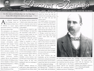
Newspaper - LONG GULLY HISTORY GROUP COLLECTION: THE MINE FLOODING CRISIS - BENDIGO'S DEPUTATION TO THE MINES MINISTER MCBRIDE
... Copy of an article from the Bendigo Weekly 25/6/2000 titled The Mine Flooding Crisis - Bendigo's Deputation to Mines Minister McBride by James Lerk. ...Newspaper LONG GULLY HISTORY GROUP COLLECTION: THE MINE FLOODING CRISIS - BENDIGO'S DEPUTATION TO THE MINES MINISTER MCBRIDE ...Copy of an article from the Bendigo Weekly 25/6/2000 titled The Mine Flooding Crisis - Bendigo's Deputation to Mines Minister McBride by James Lerk. The participants in the deputation were S H McGowan, J H Craig, G A Petrie, J G Stanfield, George Lansell Junior, H E Rowe, A Capper Moore, I E Dyason, S L Stirling, Senator McColl, J Sternberg, T Hicks and T Glass. It was hoped the Government would provide a pound for pound subsidy for the unwatering of the Victoria Quartz. Of the 11 mines, 5 were willing to contribute. The Minister thought dams would be ineffective. There is an accompanying photo of Minister Peter McBride.bendigo, history, long gully history group, the long gully history group - the mine flooding crisis - bendigo's deputation to mines minister mcbride, bendigo weekly 25/6/2000, james lerk, hon p mcbride, victoria quartz mine, s h mcgowan, bendigo mine owners association, j h craig, g a petrie, j g stanfield, george lansell junior, h e rowe, chamber of mines, a capper moore, i e dyason, d l stirling, senator mccoll, j sternberg, t hicks, t glass, new chum, lazarus, 180 mine, new chum consolidated, new chum railway mine, mr merrin, peter mcbride -
 Bendigo Historical Society Inc.
Document - HUSTLERS REEF MINE - JOHN M'CAVISTON'S WONDERFUL ESCAPE
... Ten page typed copy titled The Flooded Mine - John M'Caviston's Wonderful Escape by G. ...History House 11 Mackenzie Street Bendigo goldfields DOCUMENT Gold hustlers reef mine Hustlers Reef Mine John M'Caviston's Wonderful Escape The Flooded Mine G Mackay Hustlers Reef Company Latham & Watson's Mine Mr R Jackson Hustlers Reef Mine John M'Caviston J Hooper T O'Connor J Derby Stanlake Cahill Richard Williams Walter Chapman Ten page typed copy titled The Flooded Mine - John M'Caviston's Wonderful Escape by G. ...Ten page typed copy titled The Flooded Mine - John M'Caviston's Wonderful Escape by G. Mackay. The shift boss, John M'Caviston went to let water in the old workings of Latham and Watson's mine run more freely. He used the pick and removed a boulder. No sooner had he done this, the water burst in on him with a tremendous roar, blew his candle out and pushed him away. He escaped and warned the men as he ran. He then remembered four men at the bottom level and he went down to warn them. He descended the ladder and found them gone. He tried to get back up the ladder but could not. He went to a place where the floor had been built up. On the surface they thought he had been lost, but they started pumping and also baling. When the water level had dropped, men went down and on reaching the level one of them, Richard Williams, thought he heard a noise, and called out 'Jack'. They had found him alive.document, gold, hustlers reef mine, hustlers reef mine, john m'caviston's wonderful escape, the flooded mine, g mackay, hustlers reef company, latham & watson's mine, mr r jackson, hustlers reef mine, john m'caviston, j hooper, t o'connor, j derby, stanlake, cahill, richard williams, walter chapman -
 Bendigo Historical Society Inc.
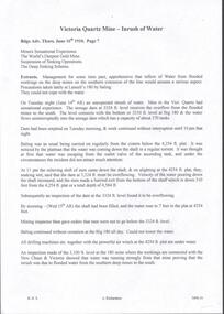
Newspaper - LONG GULLY HISTORY GROUP COLLECTION: THE MINE FLOODING CRISIS - VICTORIA QUARTZ
... Copy of an article in the Bendigo Weekly titled The Mine Flooding Crisis - Joseph Sternberg MLC gets involved by James Lerk. ...Newspaper LONG GULLY HISTORY GROUP COLLECTION: THE MINE FLOODING CRISIS - VICTORIA QUARTZ ...Copy of an article in the Bendigo Weekly titled The Mine Flooding Crisis - Joseph Sternberg MLC gets involved by James Lerk. Joseph Sternberg MLC travelled to Melbourne to arrange a deputation with the Minister of Mines to discuss the flooding of the New Chum line of reef. Pumping was mentioned but it would be expensive and would take time and the water would keep rising. They would also have to find a suitable pumping plant. The New Chum Drainage Association had kept the water under control. Delegates wanted the Government to subsidise the removal of the water.bendigo, history, long gully history group, the long gully history group - bendigo weekly, james lerk, victoria quartz, joseph sternberg, the honorable p mcbride, j h craig, new chum reef, new chum drainage association, new chum railway, mills lavis and elliot, mr w sparkman, melbourne herald, alan spicer -
 Bendigo Historical Society Inc.
Document - DRAINAGE PROBLEMS - MINERS SENSATIONAL EXPERIENCE AT THE VICTORIA QUARTZ
... Management had for some time been apprehensive that the flooding in the deep mines to the south would affect them. ...Management had for some time been apprehensive that the flooding in the deep mines to the south would affect them. ...Handwritten notes from a Bendigo Advertiser report, Thursday June 16th 1910. Management had for some time been apprehensive that the flooding in the deep mines to the south would affect them. Lansell's 180 took the precaution of baling. On the Tuesday night the men at the Victoria Quartz had a sensational experience. The storage dam at 3324 ft level receives the overflow from the flooded mines to the south. The level connects with the 3310 level at the Big 180. The water flows uninterrupted into thestorage dam which has a capacity of about 270 tanks. The dam had been emptied on Tuesday morning and work continued until 10 pm that night. The platman noticed that the water was coming down the shaft in a regular torrent. They didn't take much notice as they thought it was a leakinig outlet valve on the ascending tank. At 11 pm the releiving shift came down the shaft and said that the dam at 3,324 ft must be overflowing. The velocity of the water pouring down the shaft increased and the men made a hurried exit from the bottom of the shaft which is down 310 ft from the 4.254 ft plat (a total depth of 4,564 ft). An inspection of the dam at the 3324 ft level found it to be overflowing. By morning (Wednesday) the shaft had filled, and the water rose to 7 ft in the plat at 4254 feet. Mining inspector hgave orders that men were not to go below the 3324 ft level. Baling continued without cessation at the Big 180 all day and could not lower the water. Drilling machines etc and a powerful air winch at the 4254 ft plat are under water. An inspection made of the 3100 ft level at the 180 mine where the workings are connected with the New Chum & Victoria showed that water was running strongly from that mine proving that the inrush was due to flooded water from the southern deep mines to the south. Document from Albert Richardson Collection of mining history. Document from Albert Richardson Collection of mining history.document, gold, drainage problems, new chum drainage scheme, miners sensational experience at the victoria quartz, bendigo advertiser 16/6/1910 page7, lansell's 180, big 180, new chum & victoria -
 Bendigo Historical Society Inc.
Newspaper - LONG GULLY HISTORY GROUP COLLECTION: THE MINE FLOODING CRISIS - FINALE OF THE VICTORIA QUARTZ
... Copy of an article from the Bendigo Weekly titled Discover Bendigo The Mine Flooding Crisis - Finale of the Victoria Quartz by James Lerk. ...Newspaper LONG GULLY HISTORY GROUP COLLECTION: THE MINE FLOODING CRISIS - FINALE OF THE VICTORIA QUARTZ ...Copy of an article from the Bendigo Weekly titled Discover Bendigo The Mine Flooding Crisis - Finale of the Victoria Quartz by James Lerk. The lack of suitable machinery, insufficient knowledge of where the water was coming from, need for Government support, and the pegged price of gold, all contributed to the cessation of deep mining. The Victoria Quartz decided to allow tributers for work the upper levels. By 1913, the Company found it uneconomic to allow the tributers to continue working the upper levels and the poppet head and machinery were sold. During the Great Depression Ernest Smith, Davic Holden, Jack Harrison and David Patullo worked above the water line and did well enough to help their families from the worst effects of the Great Depression. Later Dave Patullo continued to work at the Victoria Quartz while the other three obtained employment in other mines. The article has a photo of David Patullo.bendigo, history, long gully history group, the long gully history group - the mine flooding crisis - finale of the victoria quartz, bendigo weekly, james lerk, victoria quartz mine, brough smyth, bendigo advertiser, victoria quartz company, great depression, ernest smith, david holden, jack harrison, david patullo, government battery eaglehawk -
 Bendigo Historical Society Inc.
Newspaper - LONG GULLY HISTORY GROUP COLLECTION: THE MINE FLOODING CRISIS - NEW PUMPING TECHNOLOGY SUGGESTED
... Copy of an article from the Bendigo Weekly 9/6/2000 titled The Mine Flooding Crisis - New Pumping Technology Suggested by James Lerk. ...Newspaper LONG GULLY HISTORY GROUP COLLECTION: THE MINE FLOODING CRISIS - NEW PUMPING TECHNOLOGY SUGGESTED ...Copy of an article from the Bendigo Weekly 9/6/2000 titled The Mine Flooding Crisis - New Pumping Technology Suggested by James Lerk. Louis August Samuels was born in Germany. Samuels was involved in the mining industry in Australia and he had mining experience in West Africa. He had knowledge of the mines at the southern end of the field. He was president of the Mine Managers' Association. He believed the flooding was caused by the lack of baling and pumping operations. Earlier he had visited a coal mine in Bohemia to see a Riedler pump at work. It was a new design, very effective, simple in design and reliable. He watched it work. It was 500 metres underground and pushed the water to the surface in a single column. He suggested this type of pump could be adapted to use on the New Chum Reef. Even this suggestion was not the latest technical innovation, but it would be more efficient and less costly than baling. No one took him seriously and continued to remove water by the traditional means. Article is accompanied by a photo of Samuels.bendigo, history, long gully history group, the long gully history group - the mine flooding crisis - new pumping technology suggested, bendigo weekly 9/6/2000, james lerk, louis august samuels, origin of the bendigo saddle reefs and the cause of their golden wealth 1893, bendigo mine managers' association, victoria proprietary company, victoria quartz mine, new chum drainage association, riedler pump, riedler zwangschluss valve, technical school at aix-la-chapelle (achen) -
 Ballarat Heritage Services
Photograph, Grand Duke Mine, Timor, Victoria, 04/05/2025
... When the pumps broke down in 1879 the mine flooded and remained out of action for two years. ...When the pumps broke down in 1879 the mine flooded and remained out of action for two years. ...Running through this reserve was one of Victoria's richest gold deep leads. From 1869 to 1896 this mine produced 216,000 ounces of gold, valued at over £885,000. The Timor area was mainly mined by the Duke and Timor Gold Mining Company, later known as Duchess of Timor, Duke, and Grand Duke. On 03 May 1869, at a traditional afternoon ceremony, the machinery was started and launched by the old process of 'giving it a name'. A baptismal ceremony was performed, with a Miss Eliza Watson dashing a bottle of champagne over the fly wheel on its first revolution and proclaiming its name to be 'The Galatea'. The mine here was renowned for the massive pumping engine it boasted. Imported from England, the massive Cornish pump was an improvement that was added in 1874. It had a 30 ton iron beam. The mine was the economic centre of this area, employing hundreds of men over its 27 years. At the height of its operation the company's proprietors boasted that nearly all the inhabitants of the nearby towns of Timor and Bowenvale depended on the mine for support. There were some tumultuous times at the mine, with periods of financial strife as well as accidents. When the pumps broke down in 1879 the mine flooded and remained out of action for two years. Mining was a dangerous occupation and a tragic accident in December 1883 claimed the lives of four men. As the ground here was so wet, pumping water out of the mine was crucial to safely reach the gold. It was this pumping engine, reported to be the largest of its kind in Australia, and comparable in size to just two others in the world, that was the key to the success of the Grand Duke mine. Many other smaller nearby mines also had their water pumped out. During the last seven years of the mine's operation it pumped out 2,000 gallons of water every minute, making this the longest and most continuous wet mine in the state. As well as the pump house and engine, there were four main shafts, 12 Cornish flue boilers, eight iron puddling machines and one battery of 20 heads. A massive pumping engine The arch before you is all that remains of the pump house that served to remove water from this mine. When mining started at Timor in the late 1860s the ground here was very wet. If miners were to have any success in reaching the gold they had to remove the water from the ground. To deal with this challenge the company imported a massive Cornish pumping engine from England to pump water out of the mine. It was reputed to be one of the best pumping engines in the world at the time. The engine generated 270 horsepower and its iron beam, weighing 30 tons, was the largest in Victoria. The beam of the large pumping engine see-sawed on this pump house wall to move the plunger or bucket in the pump up and down. The vertical cylinder was 80 inches in diameter with a stroke of 10 feet. The piston itself was eight inches in diameter and 17 feet high and the piston pump had a diameter of 22 inches. For such large engines a massive wall to support the beam was necessary. The piston operated on the downstroke and consequently the cylinder had to be anchored to a considerable foundation to overcome the weight of the pump rods in the shaft. The whole apparatus had to be contained in a tall building because of its vertical configuration. The pumping engine's building has beam walls six feet wide and over 26 feet long which rest on foundations 16 feet deep. The granite used to construct the arch was quarried at Mt Hooghly, some eight or nine kilometres away.Colour photographs of the Grand Duke Mine at Timor near Maryborough, Victoria.grand duke mine, timor, maryborough, mining, duke and timor gold mining company, duchess of timor -
 Kiewa Valley Historical Society
Newspaper Article - Tawonga School Centenary 1980 x2, Alpine Courier incorporating The Hydro Courier, 1980
... flooded Kiewa river. The article also covers the changes brought about by the increased employment opportunities from SEC Kiewa Works(1935), the Sawmill(1946), the Gold mine(1949) and the Tobacco Industry (largest growing area in Australia). rural school development tawonga school centenary kiewa valley development 1880 to 1980 "Centenary Celebrations For Tawonga Primary School" below this in an enclosed heading "ALPINE OBSERVER" underneath in smaller print "WITH WHICH IS INCORPORATED" below this in larger print "THE HYDRO COURIER" and below this from left to right, "No. 719 (Vol. 3) THURSDAY, 23rd OCTOBER, 1980" next "in smaller print Recommended Price Single Copy, 20c "(cents) This item is a one page (original) article of the centenary celebrations for Tawonga Primary School came from the Alpine Observer and incorporated the Hydro Courier. ...This newspaper article was produced at a time when newspapers were the main source of local information. The period before the explosion of mobile communication technology and the cost effectiveness of communication by "texting" and internet "social connections, eg. facebook and other social media networkings" The newspapers were the main links between and within large regions. The Hydro Courier was first printed in 1950 as a YMCA community service publication by Mr. Albert Clarke YMCA Officer and Mr. Alex McCullough a State Electricity Commission employee. This paper was one very important publication that provided relevant community information to all and was the major contributer to the "Valley" cohesive fibre and unity. This article not only records the celebration (centenary) of the Tawonga School but also presents the history of the school and important events such as various relocations of classrooms and how the region was settled and developed from the 1870's onward. The yawonga school opened in 1880 on 8 acres of land. It consisted of one large wooden building (22 ft x 11 ft). It had two windows, one brick chimney, bare wooden floor and a shingle roof. This article also presents the time when Mount Beauty area was likened to an island and occasionally school children could not attend school because of a flooded Kiewa river. The article also covers the changes brought about by the increased employment opportunities from SEC Kiewa Works(1935), the Sawmill(1946), the Gold mine(1949) and the Tobacco Industry (largest growing area in Australia).This item is a one page (original) article of the centenary celebrations for Tawonga Primary School came from the Alpine Observer and incorporated the Hydro Courier. It covers the arrangements for the celebration of the 100 years of the school's existence. The printed layout is typical of the typeset in use in 1980's. There are seven distinctive type collumns separated by a printed line. Three photographs are published with one photograph of a demountable classromm ,circa 1980, and the other two of student class photos of 1899 and 1914. Teacher and student names are listed below each photograph. On the back of this page are "specials" for "Sam's Cut Price Stores", specifically the Myrtleford store. Of interest is the advertisement of "Cartons of Cigarettes at cut prices". The page was produced as part of a "run" with "telltale" holes at each corner for stabilising the page in the printing process."Centenary Celebrations For Tawonga Primary School" below this in an enclosed heading "ALPINE OBSERVER" underneath in smaller print "WITH WHICH IS INCORPORATED" below this in larger print "THE HYDRO COURIER" and below this from left to right, "No. 719 (Vol. 3) THURSDAY, 23rd OCTOBER, 1980" next "in smaller print Recommended Price Single Copy, 20c "(cents)rural school development, tawonga school centenary, kiewa valley development 1880 to 1980 -
Federation University Historical Collection
Document - Technical School Reports, Technical School Report on an Apprentice, 1966
... Barker Library (top floor) Mount Helen goldfields Ballarat School of Mines Apprentice trades Carpentry and joinery electrical wiring welding printing composing motor mechanics fitting and machining bellingham plumbing gasfitting canny leviston ludbrook mcilvena penhall s.f. sartori d.w.sartori n. steinman w.m. thege richard thege w.m. thege g.h. lamb panel beating j. dellaca j.v. dellaca boilermaking j. flood i.w. flood graeme hood a.h. hood j.w howell vern howell b.w. antonio george bellingham Yellow printed apprentice reports issued by the Ballarat School of Mines. ...Yellow printed apprentice reports issued by the Ballarat School of Mines. Report include parents name and address, and their examination results.ballarat school of mines, apprentice, trades, carpentry and joinery, electrical wiring, welding, printing, composing, motor mechanics, fitting and machining, bellingham, plumbing, gasfitting, canny, leviston, ludbrook, mcilvena, penhall, s.f. sartori, d.w.sartori, n. steinman, w.m. thege, richard thege, w.m. thege, g.h. lamb, panel beating, j. dellaca, j.v. dellaca, boilermaking, j. flood, i.w. flood, graeme hood, a.h. hood, j.w howell, vern howell, b.w. antonio, george bellingham -
Federation University Historical Collection
Book - Book - Scrapbook, Ballarat School of MInes: Scrapbook of Newspaper Cuttings, Book 70, July 1995 to September 1995
... The papers concerned are The Courier, Ballarat, The Australian, The Age ad other region papers over the period of 13 May 1995 to 30 June 1995. teaching positions advertised pre-employment courses courses available enrolment for smb courses smb recognises achievements sharon boyd anne-marie vance julie hayter ellimatta exhibition b&w photo exhibition of aboriginal community since 1850s music theatre institute plan vacant sacred heart site ub new engineering course launched dennis else budding builders folio workshop courses take mystery out of computers ararat tafe funding workskill awards melissa cameron clinton miller stephen flood aaron mercer dan daly luke stevens focus on tafe colleges disabled out to improve services smb and box hill co-operate smb helps neighbourhood house geoff mainwarring painting a picture of the war v-p day playhouse-disabled children program rockie morris awards farewell to ararat technical school ruth zegir master builders association apprentice of the year ballarat university open day new craftsmen recognised associate diploma of ceramics smb development starts paul hutchison graduates exhibition opens at ararat art gallery motor mechanis top of their classes cade smart jason chetcuti Book with yellow cover, front, spiral bound. Ballarat School of MInes ...Collection of newspaper articles related to Ballarat School Of Mines.They cover activities and advertisements for staff. The papers concerned are The Courier, Ballarat, The Australian, The Age ad other region papers over the period of 13 May 1995 to 30 June 1995.Book with yellow cover, front, spiral bound. teaching positions advertised, pre-employment courses, courses available, enrolment for smb courses, smb recognises achievements, sharon boyd, anne-marie vance, julie hayter, ellimatta exhibition, b&w photo exhibition of aboriginal community since 1850s, music theatre institute plan, vacant sacred heart site, ub new engineering course launched, dennis else, budding builders, folio workshop, courses take mystery out of computers, ararat tafe funding, workskill awards, melissa cameron, clinton miller, stephen flood, aaron mercer, dan daly, luke stevens, focus on tafe colleges, disabled out to improve services, smb and box hill co-operate, smb helps neighbourhood house, geoff mainwarring, painting a picture of the war, v-p day, playhouse-disabled children program, rockie morris awards, farewell to ararat technical school, ruth zegir master builders association apprentice of the year, ballarat university open day, new craftsmen recognised, associate diploma of ceramics, smb development starts, paul hutchison graduates, exhibition opens at ararat art gallery, motor mechanis top of their classes, cade smart, jason chetcuti -
 Eltham District Historical Society Inc
Photograph, Tess Justine (Nillumbik Shire Council), Murray's Bridge over the Diamond Creek, Eltham North, 19 Feb 2022
... The mine had been previously closed and flooded. It was noted in the press at the time that the mine was within a mile of the railway. ...The mine had been previously closed and flooded. It was noted in the press at the time that the mine was within a mile of the railway. ...Murray's Bridge over the Diamond Creek on the Diamond Creek Trail just prior to demolition and replacement with a new steel bridge. Heritage advice obtained by Nillumbik Shire Council, following a suggestion by the Eltham District Historical Society (EDHS), is that the original bridge appears to have been a simplified version of the Country Roads Board’s (CRB) standard timber bridge design of the early-to-mid 1920s. In c1990 Murray’s bridge was renovated with three recycled steel girders as part of a bike/pedestrian path in the reserve. During these alterations many parts of the bridge were removed, and some were replaced. Heritage advice indicates the condition of Murray’s bridge is poor. The remaining original parts are all in poor condition, with severe weathering, splitting and rot, especially to the stringers retained on the bridge. Heritage advice is that Murray’s Bridge does not have sufficient significance in the cultural history of the Nillumbik area to warrant inclusion in the Nillumbik Shire Heritage Overlay and also does not have sufficient significance as a rare survivor to warrant inclusion in the Nillumbik Shire Heritage Overlay. There are no indications in the historical record that this site was individually important to the cultural history of this area. EDHS is comfortable with the heritage advice provided to Council and has worked closely on this project with Council. EDHS has suggested some of the removed timbers be used in the vicinity of the bridge for landscaping and possibly seating, so as to retain these remnants close to the site of the original bridge, which is the last old timber bridge along the lower reaches of the Diamond Creek. Mary (Sweeney) Murray and John Wright Murray selected 80 acres, Lot C Section 16 and Lot 5 Section 17 Parish of Nillumbik, under an occupation license in 1866. John died in 1867 and freehold was granted to his son John in 1873. The farm was known as ‘Laurel Hill’. John Junior was an Eltham Shire councillor and sometime president from 1887 up until 1897. He added Lot A Section 16 to the farm in ca1888. John and his younger brother James arranged to rent/purchase Lot B Section 17, across Diamond Creek to the west, in ca1900. It appears that John and James farmed separately for a few years, with a new homestead built for James ad family on the high point of Lot B Section 17 in ca1910. John sold off Lot 5 Section 17 in 1912. When John died in 1912 James took over the land on both sides of the Diamond Creek. The old homestead on the west side of the Creek disappeared. A farm bridge over Diamond Creek from this period may have been located close to the northern boundary of the farm. John Langlands, owner of the farm known as ‘Ihurst’ on the west side of Diamond Creek to the south of the Murray’s land, died in 1907. In 1909 his land was then subdivided into 100 lots to become the ‘Glen Park Estate’. Other similar subdivisions of nineteenth century farms around Eltham in this period included the ‘Franktonia (or Beard’s) Estate’ to the northeast and ‘Bonsack’s Estate’ between Eltham and Greensborough. Soon after the opening of the railway extension line from Eltham to Hurstbridge in 1912, Glen Park and nearby residents including James Murray agitated for a railway station or siding to be located half-way between Eltham and Hurstbridge, so that the Glen Park residents who used the railway daily did not have to walk into the Eltham or Hurstbridge stations. Some believed Coleman’s Corner (opposite Edendale Farm) was an appropriate spot for the platform. James Murray was among those who thought the railway should be located on his land, closer to half-way between Eltham and Hurstbridge stations. The Railways Commissioners warned that the locals would have to fund these works themselves. The Glen Park Estate residents initially had difficulty accessing Eltham by road, with only an old low-level bridge over Diamond Creek at the south end of their estate. A new timber trestle bridge across the creek, now on Wattletree Road, was opened in 1915. Road access to the north was gained in 1927 when the new Murray’s Road, which crossed the Murray’s land, was built. Residents continued to agitate for a Glen Park station. By 1926 the Railways Commissioners’ preferred site was on the Murray’s land. They arranged an estimate of cost of a full-length platform. The estimate was too much for the locals, who in 1928 argued unsuccessfully for a shorter and hence cheaper platform. By 1929 Murray had agreed to donate the land, but the locals would still have to fund the works. Murray decided, unilaterally it would appear, to commence work on a timber trestle road bridge over Diamond Creek to link the new Murray Road to the proposed station. Late in 1929 he stopped work on the bridge, for reasons unknown, but started work again and completed the bridge in 1931. There is no further newspaper evidence of the campaign for the Glen Park station until 1939, when Murray and another local, Mr Maxwell, met the Railways Commissioner. The Glen Park locale now included 45 homes on the west side of the creek and 20 on the Eltham side. Most of the residents used the train every day. The Commissioner remained adamant that only a full-length platform could be built for safety reasons. It appears the campaign dissolved at this point. The increasing move to cars may have had an impact. There is no evidence of Murray’s bridge ever being connected to Murray’s Road, or of it having wide use for any purpose by locals. James Murray died in 1947 and the farm was taken over by his son James (Jim). Jim started to sell off parts of the farm in the 1980s, retaining a few acres around the ca1910 homestead and building a new house there. Recreation reserves were established along the creek. In ca1990 Murray’s bridge was renovated with steel girders as part of a bike/pedestrian path in the reserve. The old farmhouse was demolished in ca2014. * * * A theory posted on local community Facebook groups was that the bridge was built in the 1860s and was built to be more robust than was necessary for the movement of cows from one side of the creek to the other. It was suggested the robustness was necessary to support the weight of gold ore being transferred from a mine on Murray’s land to a railway siding near Murrays Bridge (presumably for transfer and processing at Diamond Creek). Perhaps this may have been one of the motivators for Murray, who really knows? Knowing when mining operations ceased on his land and how that fits the overall timeline would be useful but at the time the bridge was built, local gold production was minimal at best. The known facts are: • The railway line came to Eltham in 1902. • The extension of the railway from Eltham to Hurstbridge was constructed in 1912 so no railway line even existed through Murray's property until 1912 and the Victorian Railways maps at the time show no such siding on Murray’s property. • In 1923 a new company was formed in anticipation of the old Diamond Creek Gold Mine being re-opened. The mine had been previously closed and flooded. It was noted in the press at the time that the mine was within a mile of the railway. Nothing really came of this. • Construction of Murrays Bridge was commenced by James Murray in early 1929 in anticipation of a proposed flag station being nominated on his land, but work ceased shortly afterwards. The proposed flag station was commonly referred to as Glen Park as the residents of the Glen Park Estate wanted Option 1, located near them with the platform adjacent to Colemans corner. This was probably never going to fly as it was virtually in eyesight of Eltham station. Allandale Road was the third option, but the Commissioners' preferred option was No. 2 - on Murray's property. • The Railway Commissioners were not going to finance any such station and the works had to be funded by private landowners and residents, hence Murray investing in this himself. • Murray recommenced work two years later and finished his bridge in 1931 but unfortunately for him, the proposed flag station never eventuated. The bluestone siding you reference may well have been built by Murray as part of the proposed station platform. • Up until then, apart from the Main Road bridge, which was washed away in 1924, virtually all local crossings over the Diamond Creek were low lying bridges – Kaylocks Bridge at Brougham Street, Diamond Street bridge, Glen Park Road bridge. It is expected that Murray also had a low-lying bridge to connect his land either side of the creek. These were all washed away or severely damaged multiple times in the 1920s. Lessons were learnt, and Murrays Bridge appears to have been built in accordance with Country Road Board standards of the time. Flood damage was ongoing, and even more recently constructed raised bridges kept getting washed away, e.g., the new Wattle Tree Road bridge in 1958 just months after completion. Murray’s bridge was reinforced with steel some 30 years ago presumably to provide additional floodwater resistance, given the history of bridges disappearing in floodwaters. • In March 1932 it was reported in the Advertiser that there were still some prospectors operating around Eltham North who apart from further scarring the face of the earth over the previous two years had gained significant experience but little gold - hardly a driving factor for constructing a dedicated railway siding and bridge to transfer gold ore. It is far more probable that James Murray was hoping to have the railway station located on his property and invested his money by building the bridge to lead to it as well as a station platform. Had the station eventuated, it may well have driven up the value of his land for subdivision and new housing estates like the Glen Park Estate. That did not eventuate. Whilst the bridge was indeed old (90 years), the core structure being completed in 1931, it had been modified substantially from original and hence had no significant historic value – i.e., it was not a representative example of its type, construction, and age. Given that the bridge was not worthy of saving, the Eltham District Historical Society with Council’s support, and the Eltham Woodworkers group endeavoured to see what suitable sized timbers were salvageable to fabricate a commemorative seat. Unfortunately, the experts at the Woodworkers group were unable to salvage any suitable length/width timbers to fabricate the seat due to the presence of rot. Last remaining wooden trestle bridge on the Diamond Creek Trail just prior to demolition and replacementBorn digital image (27)diamond creek (creek), diamond creek trail, murrays bridge, ‘laurel hill’, john wright murray, mary (sweeney) murra, john murray jnr, james murray, john langlands, ‘ihurst’, ‘glen park estate’, beard's estate, franktonia, bonsack's estate, glen park estate, glen park railway station -
 Bendigo Historical Society Inc.
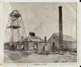
Photograph - VICTORIA QUARTZ - NEW CHUM LINE OF REEF, c.1890
... On the night of June 14th, 1910, the mine was flooded out by the rising waters from the deep New Chum mines to the south, all of which had either ceased operations or had returned back to shallow workings. ...On the night of June 14th, 1910, the mine was flooded out by the rising waters from the deep New Chum mines to the south, all of which had either ceased operations or had returned back to shallow workings. ...Black and white photograph. Poppet head on LH side, stone building, centre, tall brick chimney, RH side in front of timber building. Inscriptions: on front - 'Victoria Quartz'. On back - typewritten description as follows: 'Situated on the rich Victoria Hill, Ironbark. Steel girders? rams type poppet legs - 60ft high. Vertical winding engines; pair of 24' dia. Winding drums. Made and erected by Roberts & Sons, Bendigo, in 1897. Then one of the best in the state. In 1910 it was the deepest gold mine in the world, having reached a depth of 4,613 ft in the winze. The shaft was then sunk to a depth of 4,588 ft. in an endeavour to reach a depth of 4,870 ft. to effectively work the deepest gold bearing reef in the world. On the night of June 14th, 1910, the mine was flooded out by the rising waters from the deep New Chum mines to the south, all of which had either ceased operations or had returned back to shallow workings. For details of the mine's record, see 'The Historical Guide to Bendigo'. Mine details completed by A Richardson, 29 Harrison Street, Bendigo.place, mining site, victoria quartz -
 Bendigo Historical Society Inc.
Document - LONG GULLY HISTORY GROUP COLLECTION: DESCRIPTION OF PHOTOS
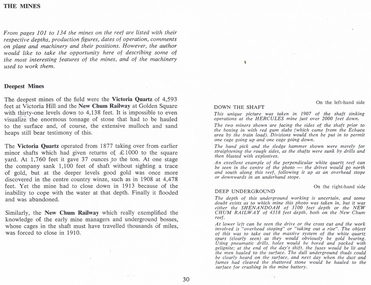
... Mines. Mentioned are the Victoria Quartz of 4,593 feet and closed in 1913 because of flooding. ...Mines. Mentioned are the Victoria Quartz of 4,593 feet and closed in 1913 because of flooding. ...Page titled The Mines. It has the description of the two black and white photos. Down the Shaft is on the left-hand side and Deep Underground is on the right-hand side. Also on the page is some information on the Deepest Mines. Mentioned are the Victoria Quartz of 4,593 feet and closed in 1913 because of flooding. The New Chum Railway of 4.138 feet closed in 1910.bendigo, history, long gully history group, the long gully history group - description of photos, hercules, shenandoah, new chum railway, victoria quartz -
 Bendigo Historical Society Inc.
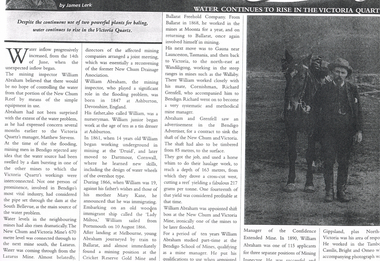
Newspaper - LONG GULLY HISTORY GROUP COLLECTION: WATER CONTINUES TO RISE IN THE VICTORIA QUARTZ
... flooding problem. Water levels had risen dramatically. Water flowed from one mine to another where they were connected. ...History House 11 Mackenzie Street Bendigo goldfields BENDIGO History long gully history group The Long Gully History Group - Water Continues to Rise in the Victoria Quartz James Lerk William Abraham New Chum Reef Matthew Stevens South Bellevue New Chum and Victoria Mine Lazarus Mine New Chum Drainage Association William Abraham Snr Mary Kane Lady Miltoa (Ship) Cricket Reserve Gold Mine Ballarat Freehold Company Wallaby Mine Richard Grenfell Bendigo Advertiser Bendigo School of Mines Confidence Extended Mine Photo of a newspaper article titled Water Continues to Rise in the Victoria Quartz by James Lerk. Article mentions William Abraham who was the mining inspector, who played a significant role in the flooding problem. ...Photo of a newspaper article titled Water Continues to Rise in the Victoria Quartz by James Lerk. Article mentions William Abraham who was the mining inspector, who played a significant role in the flooding problem. Water levels had risen dramatically. Water flowed from one mine to another where they were connected. Article also mentions Abraham's birthplace, his early start to work at the age of 10 as a tin dresser at Ashburton, Devonshire, England and his working life after he migrated to Australia at the age of 19. His career in Australia is also mentioned. The article is accompanied by a photo of Abraham with his horse.bendigo, history, long gully history group, the long gully history group - water continues to rise in the victoria quartz, james lerk, william abraham, new chum reef, matthew stevens, south bellevue, new chum and victoria mine, lazarus mine, new chum drainage association, william abraham snr, mary kane, lady miltoa (ship), cricket reserve gold mine, ballarat freehold company, wallaby mine, richard grenfell, bendigo advertiser, bendigo school of mines, confidence extended mine -
 Eltham District Historical Society Inc
Book, Diamond Creek Basin Study. Part 1, A Compendium of Factors Relevant to Stormwater Flows, 1980
... mine...arthurs creek road bridge...arthurs creek...bald spur look-out...bank protection...bolton steet...bridge street bridge...bridge street...bridges...challenger street...chute street...construction...coolaroo drive...culvert...deep creek...diamond creek basin...diamond creek region...diamond creek...diamond street bridge...drainage works...eltham lower park...eltham town park...eltham trestle bridge...eltham west drains...eltham...erosion...flood...Eltham District Historical Society Inc 728 Main Rd Eltham melbourne Basin Studies are studies to evaluate water supply and demand and help ensure reliable water supplies by identifying strategies to address imbalances in water supply and demand. aerial photographs allendale road arthurs creek mine arthurs creek road bridge arthurs creek bald spur look-out bank protection bolton steet bridge street bridge bridge street bridges challenger street chute street construction coolaroo drive culvert deep creek diamond creek basin diamond creek region diamond creek diamond street bridge drainage works eltham lower park eltham town park eltham trestle bridge eltham west drains eltham erosion flood management floods footbridge glen katherine estate gold mining gum glade hurstbridge kangaroo ground kinglake escarpment kinglake national park latiners hat factory main road bridge main road masons falls melbourne metropolitan board of works, monash bridge mount sugarloaf nillumbik park orchards railway culvert railway line ramptons road real estate advertisement research creek st helena east drain st helena road st helena storm sewers stormwater sugarloaf-preston transfer main crossing susan street union mine village pond water flow watkins street wattletree road weidlich road wingrove park yarra river zig zag road water supply basin study Spiral Bound. 157 leaves in various foliations (some folded) : illustrated. ...Basin Studies are studies to evaluate water supply and demand and help ensure reliable water supplies by identifying strategies to address imbalances in water supply and demand.Spiral Bound. 157 leaves in various foliations (some folded) : illustrated. (some colour.), maps (some colour.)aerial photographs, allendale road, arthurs creek mine, arthurs creek road bridge, arthurs creek, bald spur look-out, bank protection, bolton steet, bridge street bridge, bridge street, bridges, challenger street, chute street, construction, coolaroo drive, culvert, deep creek, diamond creek basin, diamond creek region, diamond creek, diamond street bridge, drainage works, eltham lower park, eltham town park, eltham trestle bridge, eltham west drains, eltham, erosion, flood management, floods, footbridge, glen katherine estate, gold mining, gum glade, hurstbridge, kangaroo ground, kinglake escarpment, kinglake national park, latiners hat factory, main road bridge, main road, masons falls, melbourne metropolitan board of works, monash bridge, mount sugarloaf, nillumbik park, orchards, railway culvert, railway line, ramptons road, real estate advertisement, research creek, st helena east drain, st helena road, st helena, storm sewers, stormwater, sugarloaf-preston transfer main crossing, susan street, union mine, village pond, water flow, watkins street, wattletree road, weidlich road, wingrove park, yarra river, zig zag road, water supply, basin study -
 Bendigo Historical Society Inc.
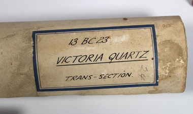
Plan - Victoria Quartz Gold Mine
... For the next three decades, the mine produced consistent profits. In 1910, water burst into the claim, flooding the shaft and halting operations. ...For the next three decades, the mine produced consistent profits. In 1910, water burst into the claim, flooding the shaft and halting operations. ...The Victoria Quartz Gold Mine was situated on Victoria Hill, Ironbark, (1877 - 1913). At the turn of the century, this was the site of one of the premier mines on the Bendigo goldfield. In 1908, it boasted the world's deepest shaft - 4,478 feet (1,365 metres). The shaft reached a depth of 4,613 feet (1,406 metres) in 1910. In 1857 eight small claims in this area had been merged to form the Victoria Reef Quartz Mining Co. Another merger in 1877 led to the formation of the Victoria Quartz Co. For the next three decades, the mine produced consistent profits. In 1910, water burst into the claim, flooding the shaft and halting operations. The company baled water for six months then handed the mine over to the tributers who worked the upper levels for the share of the profits. The mine closed in 1913, having produced over 48,000 ounces of gold and paid dividends of £99,600. (Source, Goldfield Guide https://www.goldfieldsguide.com.au/explore-location/400/victoria-hill-mining-reserve/) Victorian Heritage Register information on mine: Statement of Significance Last updated on - July 14, 2005 The story of quartz mining on Victoria Hill lies at the heart of Bendigo's historical status as the world's richest and deepest reefing field. Gold was discovered on Victoria Hill in 1854, and by early 1855 claims had been taken up over its entire extent. Shafts were first worked by windlass, whip or whim, and primitive crushing batteries were in operation. By 1861, Victoria Hill had yielded at least 1,200,000oz in gold. One of the early claims on Victoria Hill was owned by Prussian immigrants, Christopher Ballerstedt and his son Theodore. In 1854, they bought a claim on the hill for £80, to which they subsequently added other claims, and from the quartz veins (called spurs), worked both by shafts and a large open cut, obtained gold worth nearly £200,000. Christopher Ballerstedt was dubbed 'Father of the Hill' and has been credited as the first to debunk the theory at that time prevalent on the Bendigo field, that the gold content of reefs would diminish at depth. As his shafts plunged below the 200-foot level, the quartz remained rich in gold. His success inspired others, and so led the way to Bendigo's later status as the world's deepest and richest goldfield. The Ballerstedt's built Bendigo's grandest mansion, Fortuna. Theodore continued to work Victoria Hill after his father's death, but in 1871, convinced that his claim was exhausted, he sold both mine and mansion to George Lansell for £60,000. Lansell's mine on Victoria Hill was called the 180, and operated under his ownership until his death in 1906. The mine supplied the initial wealth that made Lansell Bendigo's 'Quartz King'. George Lansell was such a force in Bendigo's mining history that his death was cited as one of the reasons for the decline of Bendigo as a quartz mining centre, The Victoria Hill Quartz Gold Mines are of historical, archaeological and scientific importance to the State of Victoria. The Victoria Hill Quartz Gold Mines are historically significant as the symbolic heart of Bendigo's famous goldfield. The mines are linked to nineteenth-century individuals (Christopher Ballerstedt and George Lansell) who played prominent roles in the evolution of Bendigo. Both men's fortunes and their influence on Bendigo, originated from mining operations carried out on the hill. The Victoria Hill Quartz Gold Mines are historically and scientifically important as characteristic examples of an important form of gold mining. Gold mining sites are of crucial importance for the pivotal role they have played since 1851 in the development of Victoria. As well as being a significant producer of Victoria's nineteenth century wealth, quartz mining, with its intensive reliance on machinery, played an important role in the development of Victorian manufacturing industry. The Victoria Hill Quartz Gold Mines are important as a manifestation of this aspect of gold mining. The Victoria Hill Quartz Gold Mines are scientifically important, as they contain relics span nearly sixty years of mining (1854 to 1913), documenting the richest and most significant years of Bendigo's world-famous quartz mining industry. Enhancing the significance of the place are relics from the Victoria Quartz Company operations, ncluding, at 4,870 feet, the world's deepest nineteenth-century gold mining shaft. As a postscript to the chronology of gold mining is the surviving crushing machinery (formerly part of the Bendigo Crushing Works) which was erected near the foundations of Lansell's 180 mine in 1932, to crush quartz for nearby mines. The place has a potential to yield artefacts and evidence which will be able to provide significant information about the technological history of gold mining. [Source: Victorian Heritage Register] Hermes Number 8506 https://vhd.heritagecouncil.vic.gov.au/index.php/places/8506/download-report Hand drawn plan of the bottom section of the Victoria Quartz Gold Mine. Mine shaft shown from 2706 feet to 5200 (potential) feet shown, with annotation regarding geological features and gold obtained from different level crushings. Blue border sticker on outside of plan: '13 BC 23 Victoria Quartz Trans-Section'. Plan is not dated. The Victoria Quartz plan is part of the Margaret Roberts Collection.victoria hill quartz gold mine, victoria hill -
 Bendigo Historical Society Inc.
Photograph - AUSTIN COLLECTION: Ray Beer, Central Deborah Gold Mine
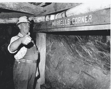
... In 1974 the mine was gazetted as a Public Historical Purposes Reserve and attracted such visitors as H.R.H Prince Charles. By far the greatest shortcoming at this stage was that no one could view the underground workings, as these had become flooded. ...In 1974 the mine was gazetted as a Public Historical Purposes Reserve and attracted such visitors as H.R.H Prince Charles. By far the greatest shortcoming at this stage was that no one could view the underground workings, as these had become flooded. ...Ray Beer was an employee of the Central Deborah Gold Mine. February 15th 2009: Bendigo Advertiser: 'MINING stalwart Raymond Beer has died at the age of 74 after a battle with cancer. He leaves behind an extended family and a legacy in Bendigo’s mining history. Ray was mine manager at the Central Deborah Gold Mine - appointed in 1978 - and led the team that made possible the underground project at the second level. He had a vision to allow visitors to go underground and experience Bendigo’s mining heritage first hand. Ray was responsible for developing the new battery, shaft and poppet head to make this a reality. It took persistence and lots of hard work. Friend and work colleague Bill McNamara said Ray was as good as 10 men. His enthusiasm and work ethic were unprecedented. Ray will be sadly missed by his wife, Thelma, six children, 15 grandchildren, seven brothers, three sisters, his extended family, and friends. He will be remembered for his kindness, tenacity and strength of character. In recognition of his contribution to Bendigo’s mining history, after more than 20 years of service at his retirement, a bronze life-sized statue was unveiled in his honour'. Central Deborah Gold Mine history: At its peak, Central Deborah Gold Mine reached a depth of 412 metres. It has 17 separate levels and 15 kilometres of drives and cross cuts (tunnels). The Central Deborah was very much a hands-on mine and the conditions that the miners worked in would be considered shocking by today's standards – being lowered underground in a cage with only two sides, often working ankle to knee deep in water, filling up to 32 ore trucks a shift by hand which were then pushed a mile or more along rails in the drives, working by carbide lamp, breathing in the fumes and rock dust and communication by bells. Geez, they were ironmen. However, at the time working conditions were considered to be among the best on the goldfields at Central Deborah, after all it was one of the only mines that had hot showers. Following Central Deborah Gold Mine's closure, the Bendigo skyline began to noticeably change. Obvious remnants of mining such as poppet heads, engine rooms, service quarters, battery houses and chimneys were steadily disappearing. After intense lobbying by the local community, the Bendigo City Council purchased the still very much intact Central Deborah Gold Mine in 1970 for a mere $6,000 to ensure that a vital link to Bendigo's historic golden past was maintained. The Bendigo Trust was then formed to oversee the operations of the Central Deborah Gold Mine, which led to the surface of the mine being opened to the public in 1971. Initially the surface was open for just 12 hours a week and as the demand for viewing a part of Bendigo's history increased, so did the opening hours. In 1974 the mine was gazetted as a Public Historical Purposes Reserve and attracted such visitors as H.R.H Prince Charles. By far the greatest shortcoming at this stage was that no one could view the underground workings, as these had become flooded. After what could only be described as a monumental effort by everyone involved, Level 2 of the mine was officially opened to the public by the Premier of Victoria, the Honourable John Cain, on 20 June 1986, which brought to fruition a long standing dream.Black and white photograph. Ray Beer, underground at Central Deborah Gold Mine, standing alongside wooden sign 'Murrell's Corner'. Sign is placed horizontally on timber supports, side of drive visible in background. Ray is wearing bib and brace overalls and hard hat with a belt around his waist. He is giving a 'thumbs up' sign. gold mining, central deborah gold mine, ray beer, mine manager -
 Bendigo Historical Society Inc.
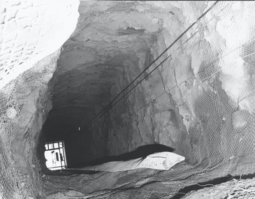
Photograph - AUSTIN COLLECTION: Central Deborah Gold Mine Lift Shaft
... In 1974 the mine was gazetted as a Public Historical Purposes Reserve and attracted such visitors as H.R.H Prince Charles. By far the greatest shortcoming at this stage was that no one could view the underground workings, as these had become flooded. ...In 1974 the mine was gazetted as a Public Historical Purposes Reserve and attracted such visitors as H.R.H Prince Charles. By far the greatest shortcoming at this stage was that no one could view the underground workings, as these had become flooded. ...Central Deborah Gold Mine history: At its peak, Central Deborah Gold Mine reached a depth of 412 metres. It has 17 separate levels and 15 kilometres of drives and cross cuts (tunnels). The Central Deborah was very much a hands-on mine and the conditions that the miners worked in would be considered shocking by today's standards – being lowered underground in a cage with only two sides, often working ankle to knee deep in water, filling up to 32 ore trucks a shift by hand which were then pushed a mile or more along rails in the drives, working by carbide lamp, breathing in the fumes and rock dust and communication by bells. Geez, they were ironmen. However, at the time working conditions were considered to be among the best on the goldfields at Central Deborah, after all it was one of the only mines that had hot showers. Following Central Deborah Gold Mine's closure, the Bendigo skyline began to noticeably change. Obvious remnants of mining such as poppet heads, engine rooms, service quarters, battery houses and chimneys were steadily disappearing. After intense lobbying by the local community, the Bendigo City Council purchased the still very much intact Central Deborah Gold Mine in 1970 for a mere $6,000 to ensure that a vital link to Bendigo's historic golden past was maintained. The Bendigo Trust was then formed to oversee the operations of the Central Deborah Gold Mine, which led to the surface of the mine being opened to the public in 1971. Initially the surface was open for just 12 hours a week and as the demand for viewing a part of Bendigo's history increased, so did the opening hours. In 1974 the mine was gazetted as a Public Historical Purposes Reserve and attracted such visitors as H.R.H Prince Charles. By far the greatest shortcoming at this stage was that no one could view the underground workings, as these had become flooded. After what could only be described as a monumental effort by everyone involved, Level 2 of the mine was officially opened to the public by the Premier of Victoria, the Honourable John Cain, on 20 June 1986, which brought to fruition a long standing dream.Black and white photograph, looking from bottom of lift shaft towards the surface; light visible at top of shaft. Lift cables and safety mesh on sides of shaft. gold mining, central deborah gold mine, ray beer, mine manager -
 Bendigo Historical Society Inc.
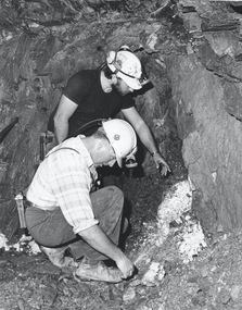
Photograph - AUSTIN COLLECTION: Central Deborah Gold Mine, Possibly 1990's
... In 1974 the mine was gazetted as a Public Historical Purposes Reserve and attracted such visitors as H.R.H Prince Charles. By far the greatest shortcoming at this stage was that no one could view the underground workings, as these had become flooded. ...In 1974 the mine was gazetted as a Public Historical Purposes Reserve and attracted such visitors as H.R.H Prince Charles. By far the greatest shortcoming at this stage was that no one could view the underground workings, as these had become flooded. ...Central Deborah Gold Mine history: At its peak, Central Deborah Gold Mine reached a depth of 412 metres. It has 17 separate levels and 15 kilometres of drives and cross cuts (tunnels). The Central Deborah was very much a hands-on mine and the conditions that the miners worked in would be considered shocking by today's standards – being lowered underground in a cage with only two sides, often working ankle to knee deep in water, filling up to 32 ore trucks a shift by hand which were then pushed a mile or more along rails in the drives, working by carbide lamp, breathing in the fumes and rock dust and communication by bells. Geez, they were ironmen. However, at the time working conditions were considered to be among the best on the goldfields at Central Deborah, after all it was one of the only mines that had hot showers. Following Central Deborah Gold Mine's closure, the Bendigo skyline began to noticeably change. Obvious remnants of mining such as poppet heads, engine rooms, service quarters, battery houses and chimneys were steadily disappearing. After intense lobbying by the local community, the Bendigo City Council purchased the still very much intact Central Deborah Gold Mine in 1970 for a mere $6,000 to ensure that a vital link to Bendigo's historic golden past was maintained. The Bendigo Trust was then formed to oversee the operations of the Central Deborah Gold Mine, which led to the surface of the mine being opened to the public in 1971. Initially the surface was open for just 12 hours a week and as the demand for viewing a part of Bendigo's history increased, so did the opening hours. In 1974 the mine was gazetted as a Public Historical Purposes Reserve and attracted such visitors as H.R.H Prince Charles. By far the greatest shortcoming at this stage was that no one could view the underground workings, as these had become flooded. After what could only be described as a monumental effort by everyone involved, Level 2 of the mine was officially opened to the public by the Premier of Victoria, the Honourable John Cain, on 20 June 1986, which brought to fruition a long standing dream.Black and white photograph. Two men with hard hats and lights, inspecting quartz outcrop on wall of drive at Central Deborah Gold Mine.gold mining, central deborah gold mine, ray beer, mine manager -
 Bendigo Historical Society Inc.
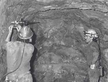
Photograph - AUSTIN COLLECTION: Operating rock drill, Central Deborah Gold Mine, Possibly 1990's
... In 1974 the mine was gazetted as a Public Historical Purposes Reserve and attracted such visitors as H.R.H Prince Charles. By far the greatest shortcoming at this stage was that no one could view the underground workings, as these had become flooded. ...In 1974 the mine was gazetted as a Public Historical Purposes Reserve and attracted such visitors as H.R.H Prince Charles. By far the greatest shortcoming at this stage was that no one could view the underground workings, as these had become flooded. ...Central Deborah Gold Mine history: At its peak, Central Deborah Gold Mine reached a depth of 412 metres. It has 17 separate levels and 15 kilometres of drives and cross cuts (tunnels). The Central Deborah was very much a hands-on mine and the conditions that the miners worked in would be considered shocking by today's standards – being lowered underground in a cage with only two sides, often working ankle to knee deep in water, filling up to 32 ore trucks a shift by hand which were then pushed a mile or more along rails in the drives, working by carbide lamp, breathing in the fumes and rock dust and communication by bells. Geez, they were ironmen. However, at the time working conditions were considered to be among the best on the goldfields at Central Deborah, after all it was one of the only mines that had hot showers. Following Central Deborah Gold Mine's closure, the Bendigo skyline began to noticeably change. Obvious remnants of mining such as poppet heads, engine rooms, service quarters, battery houses and chimneys were steadily disappearing. After intense lobbying by the local community, the Bendigo City Council purchased the still very much intact Central Deborah Gold Mine in 1970 for a mere $6,000 to ensure that a vital link to Bendigo's historic golden past was maintained. The Bendigo Trust was then formed to oversee the operations of the Central Deborah Gold Mine, which led to the surface of the mine being opened to the public in 1971. Initially the surface was open for just 12 hours a week and as the demand for viewing a part of Bendigo's history increased, so did the opening hours. In 1974 the mine was gazetted as a Public Historical Purposes Reserve and attracted such visitors as H.R.H Prince Charles. By far the greatest shortcoming at this stage was that no one could view the underground workings, as these had become flooded. After what could only be described as a monumental effort by everyone involved, Level 2 of the mine was officially opened to the public by the Premier of Victoria, the Honourable John Cain, on 20 June 1986, which brought to fruition a long standing dream.Black and white photograph. Two men with hard hats and lights standing in front of underground rock surface at Central Deborah Gold Mine. Paul Maker on left hand side of image is operating a small rock drill. John Jeffrey on right hand side is observing the procedure. gold mining, central deborah gold mine, rock drill, underground -
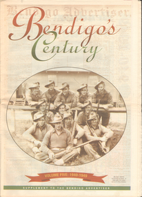 Bendigo Historical Society Inc.
Newspaper - LONG GULLY HISTORY GROUP COLLECTION: BENDIGO'S CENTURY VOLUME FIVE: 1940 - 1949
... It has two photos of women wading through the 1949 Pall Mall flood waters and one of Miners in the crib room of the Central Deborah Mine. ...Mine Ironbark South Mining Company Central Nell Gwynne Company New Chum Syncline Newspaper supplement titled Bendigo's Century Volume Five: 1940 - 1949. Each year has heading of Who's Who, Weather, Sport and Business. Front page is titled Bendigo's Century and has a photo of a group of soldiers in uniform and with rifles. They were district servicemen on leave in 1944. Each year has heading of Who's Who, Weather, Sport and Business. First years are 1940 - 1949 titled Bendigo as it was. It has two photos of women wading through the 1949 Pall Mall flood ...Newspaper supplement titled Bendigo's Century Volume Five: 1940 - 1949. Each year has heading of Who's Who, Weather, Sport and Business. Front page is titled Bendigo's Century and has a photo of a group of soldiers in uniform and with rifles. They were district servicemen on leave in 1944. Each year has heading of Who's Who, Weather, Sport and Business. First years are 1940 - 1949 titled Bendigo as it was. It has two photos of women wading through the 1949 Pall Mall flood waters and one of Miners in the crib room of the Central Deborah Mine. They are Jackie Lewis, Bob Johnson, W Landy, Ryga Yates and Les Johnson. 1940 - Army moves in to racecourse, 1941 - Devastating fire at pottery, 1942 - Forces expand, 1943 - Nation's eyes on Bendigo, 1944 - News dawns of D-day landing, 1945 - City cheers the end of the war, 1946 - Celebrations begin in city, 1947 - Gallery gets top paintings, 1948 - Water plan looks good and 1949 - Flood takes a toll on city.bendigo, history, long gully history group, the long gully history group - bendigo's century - volume five: 1940 - 1949, bendigo advertiser, central deborah mine, jackie lewis, bob johnson, w landy, ryga yates, les johnson, central nell gwynne, department of defence, bendigo jockey club, 8th division, robert menzies, deborah mine, bendigo decentralisation vigilance committee, cr w h taylor, bendigo war funds organisation, the easter fair society, bendigo agricultural show committee, mr e g ham, mr j v fairbairn, cr a staples, the bendigo chamber of commerce, richard hartley smith abbott, captain harley abbott, bendigo art gallery, bill woodfull, bendigo high school, north deborah mine, boardwalk, toni riley pharmacy, windermere hotel, cr g a pethard, coliban system, north deborah mine, bendigo pottery, bendigo trades hall council, private lawrence burstall, major-general g j rankin mhr, andrew dunstan, ordnance factory, royal australian navy, hmas bendigo, sec offices, muioof, ymca, georger addlem, fred addlem, cr a j anderson, pauline buvhan thompson, leslie thompson, edward joseph leonski, bendigo football league, mr j dedman, william stephens, forest street methodist church, pte charles phillips, pte w e durward, pte t foley, william john stephens, central nell gwynne, air chief marshall sir arthur tedder, cr taylor, united nations, flying officer, r bruce tuff, flight lieutenant owens, royal air force, commonwealth war workers housing trust scheme, mr s mckinnon, bendigo decentralised vigilance committee, ravenswood estate, john lienhop mlc, margaret (peggy) brennan, strathfieldsaye shire council, school of mines, bendigo base hospital, william george ashman, ashman's tailors, bendigo jockey club, victorian football association, bendigo east swimming pool, deborah anticline, specimen hill methodist church, north deborah, adolf hitler, benito mussolini, australian 7th division, cr galvin, bendigo war funds organisation, hmas bendigo, lt-commander jackson, bendigo football league, central deborah mine, victoria day, cr truscott, bendigo gaol, lansellstowe, awas barracks, bendigo citizens committee, john cain snr, ordnance factory, bendigo agricultural society, the duke of gloucester, duchess of gloucester, bendigo tennis association, north deborah, gillies famous pies, aids & appliance shop, mrs georgina scott, dr j a neptune scott, alfred sisley, corot, daubigney, louis sonnenberg, gas employees' union, john lienhop, soldier settlement commission, burnewang estate, king george vi, princess elizabeth, lt philip mountbatten, mr e j w herbert, ansett airways, reg ansett, most rev, dr john mccarthy, dr bernard stewart, michael giudice, bendigo united breweries, bendigo lyric photo plays, bendigo sun newspaper, shamrock hotel, west bendigo progress association, alan mcdonald, south bendigo football club, albert collier, j t webbo, mervyn tresize, state rivers and water supply commission, eppalock reservoir, public works committee, bendigo rotary club, john edgar, bendigo base hospital, albert dunstan, benevolent home, magetti's wine hall, wallace reef wine hall, magetti family, albert magetti, lance galvin, bradford cotton spinnings (victoria) pty otd, arthur syer, stanley crossman, albert arthur dunstan, rev dr henry backhaus, city family hotel, lyric theatre, bank of australasia, city club hotelcolonial mutual building, r matchett & co, lansellstowe, leonard lansell, bendigo bas hospital, australian women's army service, mr hollway, kenworth (aust) ltd, foggitt jones's bacon factory, gordon sayers, sandhurst trustees, dr john drowley, alexander hislop, royal mint, north deborah mine, ironbark south mining company, central nell gwynne company, new chum syncline