Showing 2189 items matching "floods"
-
 Tatura Irrigation & Wartime Camps Museum
Photograph - copy, 1955 Floods, 1955
... 1955 Floods...Copy of photograph of floods outside Tacey's Garage, Tatura....Black and white photograph of floods, outside Tacey's Garage, 1955....Corner Park and Hogan Streets. 1955 Floods....Corner Park and Hogan Streets. 1955 Floods. Black and white photograph of floods, outside Tacey's Garage, 1955. 1955 Floods Photograph - copy ...Copy of photograph of floods outside Tacey's Garage, Tatura.Black and white photograph of floods, outside Tacey's Garage, 1955.on back: Tacey's garage, Tatura. Corner Park and Hogan Streets. 1955 Floods.1955 floods tatura -
Tatura Irrigation & Wartime Camps Museum
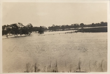
Photograph - original, Kodak, Tatura Floods 1950's, 1950's original
... Tatura Floods 1950's...Original photograph of flooded street and shops, Hogan Street Tatura, 1955...Original sepia photograph of part of Hogan Street Tatura, under flood c 1950's...on back: Hogan Street Tatura under floods c early 1950's...Tatura Irrigation & Wartime Camps Museum 49 Hogan Street Tatura the-murray Original photograph of flooded street and shops, Hogan Street Tatura, 1955 on back: Hogan Street Tatura under floods c early 1950's Original sepia photograph of part of Hogan Street Tatura, under flood c 1950's Tatura Floods 1950's Photograph - original Kodak ...Original photograph of flooded street and shops, Hogan Street Tatura, 1955Original sepia photograph of part of Hogan Street Tatura, under flood c 1950'son back: Hogan Street Tatura under floods c early 1950's -
 Kew Historical Society Inc
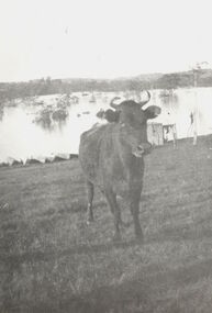
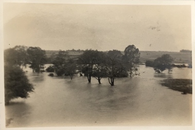
Photograph, Cattle in North Kew floods, 1934
... Cattle in North Kew floods...The year 1934 witnessed the greatest flooding of the Yarra River since settlement. ...Photograph of floodwaters encroaching on farm land in North Kew in the flood of 1934....Nth. Kew. 1934 Floods...Kew. 1934 Floods Photograph of floodwaters encroaching on farm land in North Kew in the flood of 1934. ...The year 1934 witnessed the greatest flooding of the Yarra River since settlement. This work forms part of the collection assembled by the historian Dorothy Rogers, that was donated to the Kew Historical Society by her son John Rogers in 2015. The manuscripts, photographs, maps, and documents were sourced by her from both family and local collections or produced as references for her print publications. Many were directly used by Rogers in writing ‘Lovely Old Homes of Kew’ (1961) and 'A History of Kew' (1973), or the numerous articles on local history that she produced for suburban newspapers. Most of the photographs in the collection include detailed annotations in her hand. The Rogers Collection provides a comprehensive insight into the working habits of a historian in the 1960s and 1970s. Together it forms the largest privately-donated collection within the archives of the Kew Historical Society.Photograph of floodwaters encroaching on farm land in North Kew in the flood of 1934.Nth. Kew. 1934 Floodsfloods (melbourne) 1934, dorothy rogers -
 Kew Historical Society Inc
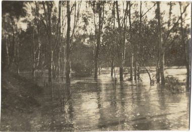
Photograph, Marnie McLeod, Floods of the River Yarra at Kew, 1916
... Floods of the River Yarra at Kew...Laver's private residence fortunately is high above flood level, but two houses he owns off Young-street have been flooded out. ...Black and white photograph of flooded trees in Kew with rising dry ground in distance....Inscription on reverse in pencil: "Flood River Yarra Kew Vic"...Laver's private residence fortunately is high above flood level, but two houses he owns off Young-street have been flooded out. ...The donation was accompanied by the following letter from the donor: "Hi. I found these in with family photos. Taken by family as Mamie McLeod was living in Fellows Street, Kew, so would be near there. Retain (or discard) as you see fit." [Donor's name and address withheld from public view]. To gain an insight into the flood levels at Kew, it is worth reading newspaper accounts of the event. The Age published an article - Valuable Gardens Destroyed at Kew - on 25 September 1916: "VALUABLE GARDENS DESTROYED AT KEW. From the heights of Studley Park, Kew, a splendid view of the flood waters can be obtained, and yesterday afternoon, despite continuous rain, crowds of citizens assembled there to witness the spectacle. There is a vast stretch of water some 300 or 400 yards broad, above the foot bridge connecting Gipps-street, Collingwood, and Studley Park. The river is only about 3 feet from the top of the embankment connecting with the ramp of the bridge on the Studiey Park side. When the upper llood waters come down it is almost a certainty that tne embankment will be submerged and the bridge rendered impassible. Below the bridge the waters again stretch out, and have submerged all the low-lying land on the Collingwood side and invaded the back premises ot the Kodak Co., Phoenix Biscuit Factory, a tannery adjoining thereto, the Shamrock Brewery, and Chinese gardens in the vicinity. At Walmer-street-bridge, at the end of Studley Park, the low-lying land on the Kew side is covered with water to the depth of many feet. Tlie land in question is owned in a great part by Mr Frank Lavers who haa gone in for intense culture on a pretty liberal scale on both the slopes of the hill and on the river flat. On the latter he is cultivating many acres of asparagus, and has at a considerable cost spent three years in preparing the ground and installing an irrigation system, reticulated from the Yan Yean water supply. This year the asparagus was put down, and the plants were in a promising condition. Tlie flood waters are now flowing fast over the land. The crop is ruined, and three years' work and expenditure destroyed. Mr. Laver's private residence fortunately is high above flood level, but two houses he owns off Young-street have been flooded out. Having been warned in time, the tenants removed their furniture hefore the water came down to Mr. Laver's residence, where they themselves have been given accommodation in the meantime. All the river flats in East Kew are under water. One or two low-lying houses have been flooded. Chipperfield's boat shed at Willsmere is nearly covered, and some Chinese gardens in the vicinity are several feet under water."This, and the other three photographs donated of floods in Kew are believed to be the earliest in the collection. Together with our original MMBW River Yarra map showing flood levels, these items, when compared allow researchers to gain a visual perspective of the extent of the flood in 1916. Black and white photograph of flooded trees in Kew with rising dry ground in distance.Inscription on reverse in pencil: "Flood River Yarra Kew Vic"river yarra, kew, floods 1916 -
 Greensborough Historical Society
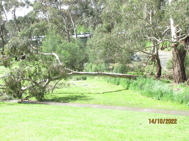
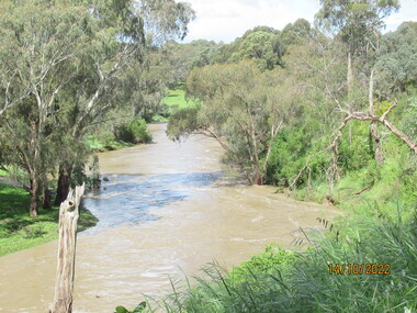
Photograph - Photograph - Digital Image, Peter Simmenauer, Plenty River floods near Plenty Lane 2022, 14/10/2022
... Plenty River floods near Plenty Lane 2022......floods...Plenty River in flood near Plenty Lane Greensborough, October 2022. ...Colour digital photographs of river in flood...Greensborough Historical Society 34A Glenauburn Road Lower Plenty Lower Plenty melbourne Plenty River in flood near Plenty Lane Greensborough, October 2022. plenty lane greensborough plenty river floods Date stamped: 14/10/2022 Colour digital photographs of river in flood Plenty River floods near Plenty Lane 2022 Photograph Photograph - Digital Image Peter Simmenauer ...Plenty River in flood near Plenty Lane Greensborough, October 2022. Colour digital photographs of river in floodDate stamped: 14/10/2022plenty lane greensborough, plenty river, floods -
 Wodonga & District Historical Society Inc
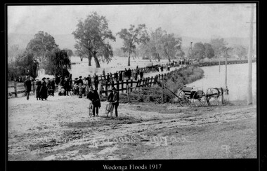
Photograph - Wodonga Floods, Robert Prentice, 1917
... Wodonga Floods ...THE 1917 floods were the second highest recorded in Albury-Wodonga. ...A black and white photograph of people observing the flood damage at Wodonga...Wodonga Floods 1917 ЯР...Floods Wodonga Natural resources Robert Prentice Wodonga Floods 1917 ЯР A black and white photograph of people observing the flood damage at Wodonga Wodonga Floods Photograph Wodonga Floods Robert Prentice ...THE 1917 floods were the second highest recorded in Albury-Wodonga. The gauge at the Union Bridge was 18 feet. All bridges between Albury and Wodonga were washed away and locals had to travel by train between the two towns. It was the only link between the centres for several weeks. The suspension bridge was a temporary fix to allow pedestrian traffic to travel between Wodonga and Albury. A report from The Argus on October 9, 1917 stated: “For the last three or four months the low-lying land between the border towns of Albury and Wodonga has been almost continuously under water, 150 points were registered here on Thursday and Friday and heavier falls were recorded higher up the river, causing all rivers to rise simultaneously. Residents of Bonegilla, Bethanga, Talgarno and the Murray Valley were cut off from railway facilities. In 2025 this location is now the Lincoln Causeway. This image is one of a collection of photos taken by Robert Prentice. The images are clearly identified as he inscribed in the glass a back-to-front capital R (Я) on to which was joined a capital P creating his mark ЯР.This image is significant because it captures a major flooding event in Wodonga and was taken by a recognised Wodonga photographer.A black and white photograph of people observing the flood damage at WodongaWodonga Floods 1917 ЯРfloods wodonga, natural resources, robert prentice -
 St Kilda Historical Society
Photograph, Elwood floods 1989 - images collection, 7/02/1989
... Elwood floods 1989 - images collection......Floods...Glenhuntly Rd floods, February 1989...Glenhuntly Road floods Feb 89...St Kilda Historical Society St Kilda Branch Library 150 Carlisle Street St Kilda melbourne Glenhuntly Rd floods, February 1989 Glenhuntly Road Floods 1989 Elwood College Elwood Secondary College Elwood Glenhuntly Road floods Feb 89 colour photograph unmounted Elwood floods 1989 - images collection Photograph ...Glenhuntly Rd floods, February 1989colour photograph unmountedGlenhuntly Road floods Feb 89glenhuntly road, floods, 1989, elwood college, elwood secondary college, elwood -
 Orbost & District Historical Society
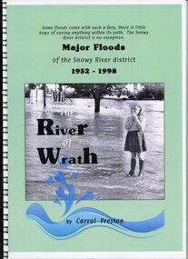
Book - Major Floods of the Snowy River 1952 to 1998, Carrol Preston, The River of Wrath Major Floods of the Snowy River 1952 to 1998 by Carrol Preston, March 2021
... The River of Wrath Major Floods of the Snowy River 1952 to 1998 by Carrol Preston......floods...The Snowy River has had many floods. This book records floods from 1952 to 1998. ...Some floods come with such a fury, there is little hope of saving anything within its path. ...The Snowy River has had many floods. This book records floods from 1952 to 1998. ...The Snowy River has had many floods. This book records floods from 1952 to 1998. This book collates of photographs and previous written articles particlularly from the Snowy River Mail.This book is significant because it records major flood events impacting Orbost and surrounding district between 1952 and 1998.A book with a blue green cover and a large black and white photograph of a young girl standing in water . Black printing, and at the bottom of the cover page is a blue water splash. 104 pages, spiral bound, plastic cover.Some floods come with such a fury, there is little hope of saving anything within its path. The Snowy River district is no exception. Major Floods of the Snowy River district 1952 - 1998 The River of Wrath by Carrol Preston snowy river, floods, orbost -
Tatura Irrigation & Wartime Camps Museum
Newspaper cuttings, The Age, Queensland and Victoria Floods 2011, January 2011
... Queensland and Victoria Floods 2011...9 cuttings from The Age newspaper, January 2011 regarding the Queensland and Victorian record floods....articles and photos of floods...Tatura Irrigation & Wartime Camps Museum 49 Hogan Street Tatura the-murray Queensland floods Victoria floods articles and photos of floods 9 cuttings from The Age newspaper, January 2011 regarding the Queensland and Victorian record floods. ...9 cuttings from The Age newspaper, January 2011 regarding the Queensland and Victorian record floods.articles and photos of floodsqueensland floods, victoria floods -
 Kew Historical Society Inc
Photograph, Floods in North Kew, 1934
... Floods in North Kew...The great flood of 1934 in Melbourne was one of the most devastating floods since records began. ...Floods in North Kew, 1934. Flood near Lagoon (Billabong?) ...Locally significant photographs of the impact of flooding in Kew in 1934 floods (kew) 1934 yarra river Floods in North Kew, 1934. ...The great flood of 1934 in Melbourne was one of the most devastating floods since records began. The floods affected all of Melbourne, including Kew.Locally significant photographs of the impact of flooding in Kew in 1934Floods in North Kew, 1934. Flood near Lagoon (Billabong?) Willsmere Road, North Kew.floods (kew) 1934, yarra river -
 Eltham District Historical Society Inc
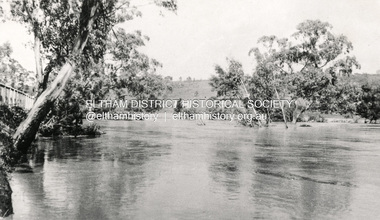
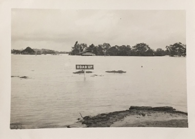
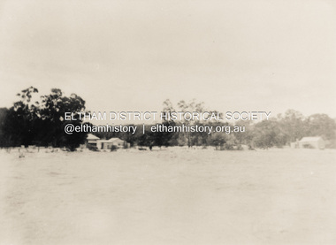
Photograph, 1934 Floods at Eltham
... 1934 Floods at Eltham...floods...In 1934 extensive flooding of the Yarra River and Diamond Creek set new records for flood plain level (Eltham Chronology, EDHS)...Copied by Hugh Fisher, Photographer, 6 York Street Eltham A1678B Floods- Eltham - 1934...In 1934 extensive flooding of the Yarra River and Diamond Creek set new records for flood plain level (Eltham Chronology, EDHS) floods yarra river eltham flooding diamond creek flood Copied by Hugh Fisher, Photographer, 6 York Street Eltham A1678B Floods- Eltham - 1934 Black and white photograph 1934 Floods at Eltham Photograph Photograph ...Published in the Diamond Creek Basin Study, 1980 and identified at Diamond Creek, locality not identified, 1934. The location is actually looking south across the Diamond Creek towards Falkiner Street, beside the Main Road bridge at Eltham South from what is now part of Wingrove Park opposite Antoinette Boulevard. The bridge railing is just visible to the left of image. The large leaning Manna Gum beside the bridge still stands in 2021 alongside the Diamond Creek trail. In 1934 extensive flooding of the Yarra River and Diamond Creek set new records for flood plain level (Eltham Chronology, EDHS)Black and white photographCopied by Hugh Fisher, Photographer, 6 York Street Eltham A1678B Floods- Eltham - 1934floods, yarra river, eltham, flooding, diamond creek, flood -
 Wodonga & District Historical Society Inc
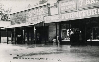
Photograph - Chiltern Floods, Thomas Bonsema, 1919
... Chiltern Floods...Three black and white images of Chiltern under flood waters on 27th December 1919. The building on the left in photo number 1 is the business premises of T. ...CONNESS ST IN FLOOD 27 12 19, TB...Bonsema, Photographer. Chiltern Floods Photograph Chiltern Floods Thomas Bonsema ...Chiltern is situated on the Black Dog Creek was originally known as the Black Dog township. It was officially gazetted as a town in 185. During 1853-54 the name was changed to Chiltern due to the resemblance of the countryside to Chiltern Hills in England. The first township lots were sold in June 1854. After the goldrushes Chiltern remained a prosperous community with a thriving economy based on agriculture, timber, and small enterprises. Born in Wodonga, after his marriage Thomas Peter Bonsema operated his photography business in Chiltern. Our Collection includes several photographs signed BONSEMA WODONGA or sometimes simply TBW. Thomas Peter John Bonsema was born in Wodonga in 1876 to Peter John Bonsema and Mary Ann nee Nash. His name first appears on the Electoral Roll for Wodonga in 1909 and on the Electoral Roll in 1912 he is listed as a photographer. His photographs capture many scenes and events around Wodonga and surrounding areas. Thomas Bonsema married Minna Louisa Jones in 1912. By 1914 he had moved to Chiltern, Victoria where he established Bonsema’s Photographic Studio. From this time onward many of his works bore the signature “BONSEMA CHILTERN”. As well as continuing to photograph landscapes and important buildings, Mr Bonsema was often the official photographer at school and community celebrations. He also sold many framed photographs and postcards from his premises at 68 -70 Conness Street, Chiltern. By 1943 Thomas John Bonsema had relocated to New South Wales and died in Beecroft, NSW on 14th July 1944. Some of his photographs are held in the Victorian State Library and Mitchell Library Sydney Collections.These images are significant because they are the work of a recognised photographer Thomas Bonsema who was born in Wodonga in 1876. Three black and white images of Chiltern under flood waters on 27th December 1919. The building on the left in photo number 1 is the business premises of T. Bonsema, Photographer.CONNESS ST IN FLOOD 27 12 19, TBbonsema photography, thomas peter john bonsema, chiltern floods -
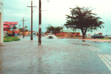
 Charlton Golden Grains Museum Inc
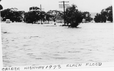
Photograph, B/W photograph 1973 Flash Flood on Calder Highway
... B/W photograph 1973 Flash Flood on Calder Highway......Floods...1973 Flash Flood on Calder Highway...Unframed B/W photograph 1973 Flash Flood on Calder Highway...Flood Calder Highway, Flash flood...Charlton Golden Grains Museum Inc 1 High Street Charlton goldfields 1973 Flash Flood on Calder Highway Charlton Calder Highway Floods Flood Calder Highway, Flash flood Unframed B/W photograph 1973 Flash Flood on Calder Highway B/W photograph 1973 Flash Flood on Calder Highway Photograph Photograph ...1973 Flash Flood on Calder HighwayUnframed B/W photograph 1973 Flash Flood on Calder HighwayFlood Calder Highway, Flash floodcharlton, calder highway, floods -
 Kew Historical Society Inc
Photograph, Floods in North Kew, 1934
... Floods in North Kew...Newspapers continued to describe major flooding in Kew in 1863, 1869, 1878, 1880, 1889, 1891, 1916 and 1934. ...Floods in North Kew, 1934. Flood near the lagoon (Billabong?)...Numerous photographs record flooding throughout the Twentieth Century. floods (kew) 1934 yarra river Floods in North Kew, 1934. ...Living with natural processes was frequently a challenge to early European settlers and later residents of what was in the 1850s administered by the Borondara Road Board. This was compounded by the area being bounded on three sides by rivers (Yarra River, Koonung Creek and Gardiner's Creek). In 1849, the historian James Bonwick recorded that "our district [Kew] suffered considerably. Mr Wade speaks of 80 acres, out of 100 acres of his cultivated paddock, covered by water." Newspapers continued to describe major flooding in Kew in 1863, 1869, 1878, 1880, 1889, 1891, 1916 and 1934. While the construction of the Upper Yarra dam in 1957 reduced the levels of flowing downstream, local and riverine floods continue.The Kew Historical Society's pictures and map collections testify to the impact of flooding in the district. They have historical importance in documenting the extent of flooding in the district and its affects on homes, services and recreation. Numerous photographs record flooding throughout the Twentieth Century.Floods in North Kew, 1934. Flood near the lagoon (Billabong?)floods (kew) 1934, yarra river -
 St Kilda Historical Society
Photograph, St Kilda floods, 23 January 1991 - images collection, 23/01/1991
... St Kilda floods, 23 January 1991 - images collection...Heavy rains caused flooding in the Port Phillip area on 23 January 1991, including in St Kilda. ...Flood 23/1/91 9.30am...The level of Elster Creek, Elsternwick, rose to 2.54m (from normal level of 0.1m) and there was historically high flooding along Elwood Canal St Kilda Flood 1991 23 January 1991 23/01/91 Flood 23/1/91 9.30am Colour photograph St Kilda floods, 23 January 1991 - images collection Photograph ...Heavy rains caused flooding in the Port Phillip area on 23 January 1991, including in St Kilda. The level of Elster Creek, Elsternwick, rose to 2.54m (from normal level of 0.1m) and there was historically high flooding along Elwood CanalColour photographFlood 23/1/91 9.30amst kilda, flood 1991, 23 january 1991, 23/01/91 -
 Kew Historical Society Inc
Photograph, Floods in North Kew, 1934
... Floods in North Kew...Newspapers continued to describe major flooding in Kew in 1863, 1869, 1878, 1880, 1889, 1891, 1916 and 1934. ...Floods in North Kew, 1934. Chipperfield's Boat House under flood....Chipperfield's Boat House under flood. Floods in North Kew Photograph Photograph ...Living with natural processes was frequently a challenge to early European settlers and later residents of what was in the 1850s administered by the Borondara Road Board. This was compounded by the area being bounded on three sides by rivers (Yarra River, Koonung Creek and Gardiner's Creek). In 1849, the historian James Bonwick recorded that "our district [Kew] suffered considerably. Mr Wade speaks of 80 acres, out of 100 acres of his cultivated paddock, covered by water." Newspapers continued to describe major flooding in Kew in 1863, 1869, 1878, 1880, 1889, 1891, 1916 and 1934. While the construction of the Upper Yarra dam in 1957 reduced the levels of flowing downstream, local and riverine floods continue.The Kew Historical Society's pictures and map collections testify to the impact of flooding in the district. They have historical importance in documenting the extent of flooding in the district and its affects on homes, services and recreation. Numerous photographs record flooding throughout the Twentieth Century.Floods in North Kew, 1934. Chipperfield's Boat House under flood.floods (kew) 1934, yarra river, chipperfield's boat house -
 Kew Historical Society Inc
Photograph, Floods in North Kew, 1934
... Floods in North Kew...Newspapers continued to describe major flooding in Kew in 1863, 1869, 1878, 1880, 1889, 1891, 1916 and 1934. ...Floods in North Kew, 1934. Unidentified location on the Yarra Flood Plain at Kew....Numerous photographs record flooding throughout the Twentieth Century. floods (kew) 1934 yarra river Floods in North Kew, 1934. ...Living with natural processes was frequently a challenge to early European settlers and later residents of what was in the 1850s administered by the Borondara Road Board. This was compounded by the area being bounded on three sides by rivers (Yarra River, Koonung Creek and Gardiner's Creek). In 1849, the historian James Bonwick recorded that "our district [Kew] suffered considerably. Mr Wade speaks of 80 acres, out of 100 acres of his cultivated paddock, covered by water." Newspapers continued to describe major flooding in Kew in 1863, 1869, 1878, 1880, 1889, 1891, 1916 and 1934. While the construction of the Upper Yarra dam in 1957 reduced the levels of flowing downstream, local and riverine floods continue.The Kew Historical Society's pictures and map collections testify to the impact of flooding in the district. They have historical importance in documenting the extent of flooding in the district and its affects on homes, services and recreation. Numerous photographs record flooding throughout the Twentieth Century.Floods in North Kew, 1934. Unidentified location on the Yarra Flood Plain at Kew.floods (kew) 1934, yarra river -
 Lakes Entrance Historical Society
Photograph, Lakes Post Newspaper, Esplanade floods, Lakes Entrance Victoria 1998, 1/06/1998 12:00:00 AM
... Esplanade floods, Lakes Entrance Victoria 1998...Floods...Colour photograph taken during floods of part of Esplanade Lakes Entrance Victoria...Floods Gippsland Lakes Natural Disasters Colour photograph taken during floods of part of Esplanade Lakes Entrance Victoria Esplanade floods, Lakes Entrance Victoria 1998 Photograph Lakes Post Newspaper ...Colour photograph taken during floods of part of Esplanade Lakes Entrance Victoriafloods, gippsland lakes, natural disasters -
 Eltham District Historical Society Inc
Photograph, North Eltham floods, 1924, 1924
... North Eltham floods, 1924...floods...Colour photograph of original showing Diamond Creek in flood at north Eltham 1924...Eltham District Historical Society Inc 728 Main Rd Eltham melbourne floods diamond creek eltham north eltham Colour photograph of original showing Diamond Creek in flood at north Eltham 1924 North Eltham floods, 1924 Photograph Photograph ...Colour photograph of original showing Diamond Creek in flood at north Eltham 1924floods, diamond creek, eltham, north eltham -
Kew Historical Society Inc
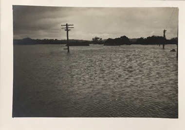
Collection, Floods in North Kew (Series), 1929–1934
... Floods in North Kew (Series)...The Municipality of Kew's response to these floods was to enact planning decisions restricting residential development in flood prone areas following the floods of 1916, 1921 and 1934. ...Individual photos include the dates of different floods. Many of the photos were taken from the rear of 8 Kellett Grove; a house still extant in 2023...The Municipality of Kew's response to these floods was to enact planning decisions restricting residential development in flood prone areas following the floods of 1916, 1921 and 1934. ...Flooding of the Yarra Valley, including that section of the Yarra bordering Kew and Kew East in the north and west of the municipality, was a regular occurrence. Extreme flood events of the Yarra River are recorded to have occurred in 1891, 1901, 1916, 1923 and 1934. The Municipality of Kew's response to these floods was to enact planning decisions restricting residential development in flood prone areas following the floods of 1916, 1921 and 1934. While floods continued after the development of the Upper Yarra Reservoir (construction 1948-57), the regularity and extent of these inundations diminished. Natural disasters had an impact on the development and settlement of Melbourne and its suburbs. Flooding in the Melbourne region was a regular event in the nineteenth and for most of the twentieth centuries. Changes in the impact of natural disasters could occur due to a number of factors. This collection of small snapshots, mostly taken from Kellett Grove in North Kew, provide provenanced evidence of flooding in the area before the development of the unnatural flood barrier that is the Eastern Freeway.Collection of 16 monochrome photographs, annotated on verso by different hands, of the flooding of the River Yarra in North Kew in the third and fourth decades of the twentieth century [1920s & 1930s]. Individual photos include the dates of different floods. Many of the photos were taken from the rear of 8 Kellett Grove; a house still extant in 2023yarra river -- north kew, floods -- yarra valley, floods -- north kew, floods -- 1929, floods -- 1934, natural disasters -- kew -
Eltham District Historical Society Inc
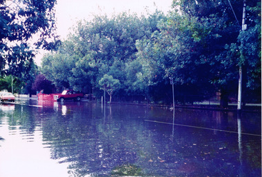
Photograph, Floods Falkiner Street, Eltham, 1956, 1956
... Floods Falkiner Street, Eltham, 1956......floods...Four photographs of floods in Falkiner Street area, Eltham, October 1956...Eltham District Historical Society Inc 728 Main Rd Eltham melbourne diamond creek floods falkiner street main road eltham Four photographs of floods in Falkiner Street area, Eltham, October 1956 Floods Falkiner Street, Eltham, 1956 Photograph Photograph ...Four photographs of floods in Falkiner Street area, Eltham, October 1956diamond creek, floods, falkiner street, main road, eltham -
 Kew Historical Society Inc
Photograph, Floods in North Kew, 1934
... Floods in North Kew...Newspapers continued to describe major flooding in Kew in 1863, 1869, 1878, 1880, 1889, 1891, 1916 and 1934. ...Floods in North Kew, 1934. Vicinity of Willsmere Park....Numerous photographs record flooding throughout the Twentieth Century. floods (kew) Floods in North Kew, 1934. ...Living with natural processes was frequently a challenge to early European settlers and later residents of what was in the 1850s administered by the Borondara Road Board. This was compounded by the area being bounded on three sides by rivers (Yarra River, Koonung Creek and Gardiner's Creek). In 1849, the historian James Bonwick recorded that "our district [Kew] suffered considerably. Mr Wade speaks of 80 acres, out of 100 acres of his cultivated paddock, covered by water." Newspapers continued to describe major flooding in Kew in 1863, 1869, 1878, 1880, 1889, 1891, 1916 and 1934. While the construction of the Upper Yarra dam in 1957 reduced the levels of flowing downstream, local and riverine floods continue.The Kew Historical Society's pictures and map collections testify to the impact of flooding in the district. They have historical importance in documenting the extent of flooding in the district and its affects on homes, services and recreation. Numerous photographs record flooding throughout the Twentieth Century.Floods in North Kew, 1934. Vicinity of Willsmere Park.floods (kew) -
 Eltham District Historical Society Inc
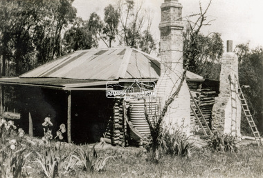
Photograph - Black and White Print, Old settler's cottage, Floods Lane, North Warrandyte, c.1935
... Old settler's cottage, Floods Lane, North Warrandyte...An early settler's cottage of 1920s vintage near Floods Rd taken in the 1930s. Was originally Floods Lane and became Floods Road off Kangaroo Ground-Warrandyte Rd near boundary of North Warrandyte...Inscribed in pencil on reverse "early 20's near Flood Rd taken 30's. 21/1.89" and in pen ".16/1.80"...Eltham District Historical Society Inc 728 Main Rd Eltham melbourne An early settler's cottage of 1920s vintage near Floods Rd taken in the 1930s. Was originally Floods Lane and became Floods Road off Kangaroo Ground-Warrandyte Rd near boundary of North Warrandyte Cottage Floods Lane Floods Road houses Kangaroo Ground-Warrandyte Road North Warrandyte pioneers Inscribed in pencil on reverse "early 20's near Flood Rd taken 30's. 21/1.89" and in pen ".16/1.80" Black and white print on photo paper Old settler's cottage, Floods Lane, North Warrandyte Photograph Black and White Print ...An early settler's cottage of 1920s vintage near Floods Rd taken in the 1930s. Was originally Floods Lane and became Floods Road off Kangaroo Ground-Warrandyte Rd near boundary of North WarrandyteInscribed in pencil on reverse "early 20's near Flood Rd taken 30's. 21/1.89" and in pen ".16/1.80"cottage, floods lane, floods road, houses, kangaroo ground-warrandyte road, north warrandyte, pioneers -
 Lakes Entrance Historical Society
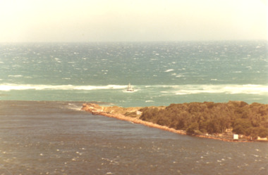
Photograph, Jack Donelly, Floods water at the Entrance Lakes Entrance 1998, 1998 c
... Floods water at the Entrance Lakes Entrance 1998...Floods...Colour photograph showing discoloured flood water backed up by the incoming tide with fishing boat Crianda shown approaching the Western Pier at the entrance Lakes Entrance Victoria...Photograph taken from Jemmys Point Floods Accommodation Colour photograph showing discoloured flood water backed up by the incoming tide with fishing boat Crianda shown approaching the Western Pier at the entrance Lakes Entrance Victoria Floods water at the Entrance Lakes Entrance 1998 Photograph Jack Donelly ...Photograph taken from Jemmys PointColour photograph showing discoloured flood water backed up by the incoming tide with fishing boat Crianda shown approaching the Western Pier at the entrance Lakes Entrance Victoriafloods, accommodation -
 Lakes Entrance Historical Society
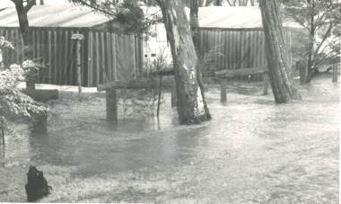
Photograph, Bairnsdale Advertiser, East Gippsland Floods 1988, 1/11/1988 12:00:00 AM
... East Gippsland Floods 1988...Also two other black and white photographs of raging flood waters during same flood event. 04933.1 10 x 17 cm and 04933.2 18 x 24.5 cm...Black and white photograph showing flood waters flowing through a camping park with two large tents and a caravan surrounded East Gippsland Victoria...Lakes Entrance Historical Society 4 Marine Parade Lakes Entrance gippsland Also two other black and white photographs of raging flood waters during same flood event. 04933.1 10 x 17 cm and 04933.2 18 x 24.5 cm Oil and Gas Industry Black and white photograph showing flood waters flowing through a camping park with two large tents and a caravan surrounded East Gippsland Victoria East Gippsland Floods 1988 Photograph Bairnsdale Advertiser ...Also two other black and white photographs of raging flood waters during same flood event. 04933.1 10 x 17 cm and 04933.2 18 x 24.5 cmBlack and white photograph showing flood waters flowing through a camping park with two large tents and a caravan surrounded East Gippsland Victoriaoil and gas industry -
Eltham District Historical Society Inc
Photograph, Diamond Creek floods, 1953, 1953
... Diamond Creek floods, 1953......floods...Three photographs of floods Diamond Creek, Eltham, 21/10/1953, showing Brougham Street and Main Road near Eltham Primary School...Eltham District Historical Society Inc 728 Main Rd Eltham melbourne diamond creek floods brougham street main road Three photographs of floods Diamond Creek, Eltham, 21/10/1953, showing Brougham Street and Main Road near Eltham Primary School Diamond Creek floods, 1953 Photograph ...Three photographs of floods Diamond Creek, Eltham, 21/10/1953, showing Brougham Street and Main Road near Eltham Primary Schooldiamond creek, floods, brougham street, main road -
 Clunes Museum
Photograph, FLOODS 1934
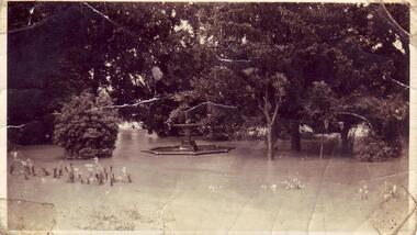
... FLOODS 1934...AFTER HEAVY RAINS - CRESWICK CREEK IN CLUNES TOWNSHIP FLOODED, OVER FLOWING ITS BANKS, NEAR BY AREAS WERE SUBMERGED....BLACK AND WHITE SMALL PHOTOGRAPH OF CLUNES FLOODS IN 1934. CLUNES QUEEN'S PARK WITH FOUNTAIN UNDER WATER - TREES IN THE BACKGROUND AND A FEW FLOWERS IN THE FOREGROUND....FLOODS 1934 BLACK AND WHITE SMALL PHOTOGRAPH OF CLUNES FLOODS IN 1934. ...AFTER HEAVY RAINS - CRESWICK CREEK IN CLUNES TOWNSHIP FLOODED, OVER FLOWING ITS BANKS, NEAR BY AREAS WERE SUBMERGED.BLACK AND WHITE SMALL PHOTOGRAPH OF CLUNES FLOODS IN 1934. CLUNES QUEEN'S PARK WITH FOUNTAIN UNDER WATER - TREES IN THE BACKGROUND AND A FEW FLOWERS IN THE FOREGROUND.local history, queen's park garden., floods 1934 -
 Orbost & District Historical Society
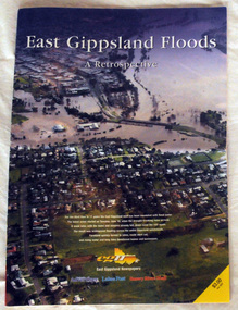
pictorial magazine, East Gippsland Floods A Retrospective, 2007
... East Gippsland Floods A Retrospective...This magazine pictorial was produced by East Gippsland News as a record of the Floods of June/July 2007....A magazine pictorial with photos of the June/July East Gippsland flood event in 2007. Photos are of Bairnsdale, Lakes Entrance, Lake Tyers, Orbost, Linenow, Metung, Eagle Point and Paynesville....Orbost & District Historical Society Ruskin Street Orbost gippsland This magazine pictorial was produced by East Gippsland News as a record of the Floods of June/July 2007. This is a contemporary record of a local event. floods-east gippsland disasters-flood A magazine pictorial with photos of the June/July East Gippsland flood event in 2007. ...This magazine pictorial was produced by East Gippsland News as a record of the Floods of June/July 2007.This is a contemporary record of a local event.A magazine pictorial with photos of the June/July East Gippsland flood event in 2007. Photos are of Bairnsdale, Lakes Entrance, Lake Tyers, Orbost, Linenow, Metung, Eagle Point and Paynesville.floods-east gippsland disasters-flood -
 Greensborough Historical Society
Photograph - Photograph - Digital Image, Peter Simmenauer, Plenty River floods near Plenty Lane 2022, 14/10/2022
... Plenty River floods near Plenty Lane 2022......floods...Plenty River in flood near Plenty Lane October 2022 Greensborough. ...Greensborough Historical Society 34A Glenauburn Road Lower Plenty Lower Plenty melbourne Plenty River in flood near Plenty Lane October 2022 Greensborough. plenty lane greensborough plenty river floods Date stamped: 14/10/2022 Colour digital photograph Plenty River floods near Plenty Lane 2022 Photograph Photograph - Digital Image Peter Simmenauer ...Plenty River in flood near Plenty Lane October 2022 Greensborough. Colour digital photographDate stamped: 14/10/2022plenty lane greensborough, plenty river, floods -
 Kew Historical Society Inc
Photograph, Marnie McLeod, Floods on the River Yarra at Kew, 1916
... Floods on the River Yarra at Kew...Laver's private residence fortunately is high above flood level, but two houses he owns off Young-street have been flooded out. ...Inscription on reverse in ink "(pre 1920) Flood from Zig-zag bridge Yarra River, Kew Vic."...Laver's private residence fortunately is high above flood level, but two houses he owns off Young-street have been flooded out. ...The donation was accompanied by the following letter from the donor: "Hi. I found these in with family photos. Taken by family as Mamie McLeod was living in Fellows Street, Kew, so would be near there. Retain (or discard) as you see fit." [Donor's name and address withheld from public view]. To gain an insight into the flood levels at Kew, it is worth reading newspaper accounts of the event. The Age published an article - Valuable Gardens Destroyed at Kew - on 25 September 1916: "VALUABLE GARDENS DESTROYED AT KEW. From the heights of Studley Park, Kew, a splendid view of the flood waters can be obtained, and yesterday afternoon, despite continuous rain, crowds of citizens assembled there to witness the spectacle. There is a vast stretch of water some 300 or 400 yards broad, above the foot bridge connecting Gipps-street, Collingwood, and Studley Park. The river is only about 3 feet from the top of the embankment connecting with the ramp of the bridge on the Studiey Park side. When the upper llood waters come down it is almost a certainty that tne embankment will be submerged and the bridge rendered impassible. Below the bridge the waters again stretch out, and have submerged all the low-lying land on the Collingwood side and invaded the back premises ot the Kodak Co., Phoenix Biscuit Factory, a tannery adjoining thereto, the Shamrock Brewery, and Chinese gardens in the vicinity. At Walmer-street-bridge, at the end of Studley Park, the low-lying land on the Kew side is covered with water to the depth of many feet. Tlie land in question is owned in a great part by Mr Frank Lavers who haa gone in for intense culture on a pretty liberal scale on both the slopes of the hill and on the river flat. On the latter he is cultivating many acres of asparagus, and has at a considerable cost spent three years in preparing the ground and installing an irrigation system, reticulated from the Yan Yean water supply. This year the asparagus was put down, and the plants were in a promising condition. Tlie flood waters are now flowing fast over the land. The crop is ruined, and three years' work and expenditure destroyed. Mr. Laver's private residence fortunately is high above flood level, but two houses he owns off Young-street have been flooded out. Having been warned in time, the tenants removed their furniture hefore the water came down to Mr. Laver's residence, where they themselves have been given accommodation in the meantime. All the river flats in East Kew are under water. One or two low-lying houses have been flooded. Chipperfield's boat shed at Willsmere is nearly covered, and some Chinese gardens in the vicinity are several feet under water."This, and the other three photographs donated of floods in Kew are believed to be the earliest in the collection. Together with our original MMBW River Yarra map showing flood levels, these items, when compared allow researchers to gain a visual perspective of the extent of the flood in 1916. Panoramic view, believed to be looking north towards Fairfield from the Zig-Zag Bridge on the River Yarra. The inscription on the reverese identifies it as taken before 1920.Inscription on reverse in ink "(pre 1920) Flood from Zig-zag bridge Yarra River, Kew Vic."river yarra, kew, floods 1916, zig-zag bridge