Showing 532 items matching "floods road"
-
 Eltham District Historical Society Inc
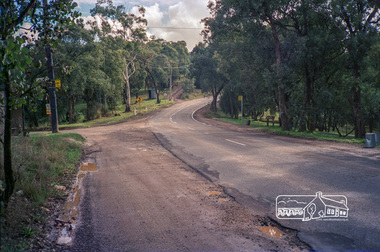
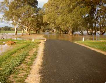
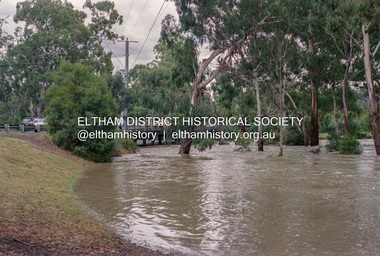
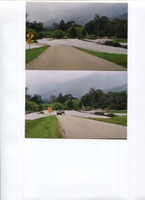
Photograph, Kangaroo Ground-Warrandyte Road, North Warrandyte, c.1988, 1988c
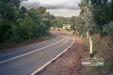
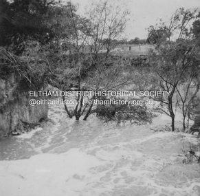
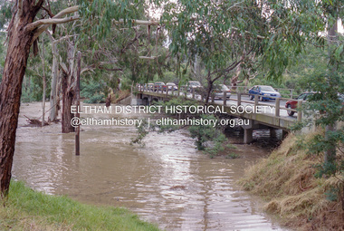
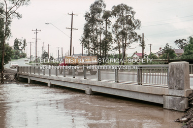
... ...Floods Road...Looking northwest, Floods Road on left....Eltham District Historical Society Inc 728 Main Rd Eltham melbourne Looking northwest, Floods Road on left. eltham shire council infrastructure kangaroo ground-warrandyte road north warrandyte Floods Road Fuji 100 Roll of 35mm colour negative film, 7 strips Kangaroo Ground-Warrandyte Road, North Warrandyte, c.1988 Photograph ...Looking northwest, Floods Road on left.Roll of 35mm colour negative film, 7 stripsFuji 100eltham shire council, infrastructure, kangaroo ground-warrandyte road, north warrandyte, floods road -
 Eltham District Historical Society Inc
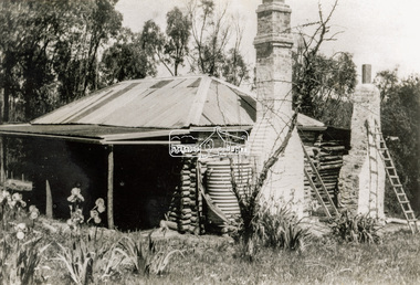
Photograph - Black and White Print, Old settler's cottage, Floods Lane, North Warrandyte, c.1935
... ...Floods Road...Was originally Floods Lane and became Floods Road off Kangaroo Ground-Warrandyte Rd near boundary of North Warrandyte...Was originally Floods Lane and became Floods Road off Kangaroo Ground-Warrandyte Rd near boundary of North Warrandyte Cottage Floods Lane Floods Road houses Kangaroo Ground-Warrandyte Road North Warrandyte pioneers Inscribed in pencil on reverse "early 20's near Flood Rd taken 30's. 21/1.89" and in pen ".16/1.80" Black and white print on photo paper Old settler's cottage, Floods Lane, North Warrandyte Photograph Black and White Print ...An early settler's cottage of 1920s vintage near Floods Rd taken in the 1930s. Was originally Floods Lane and became Floods Road off Kangaroo Ground-Warrandyte Rd near boundary of North WarrandyteInscribed in pencil on reverse "early 20's near Flood Rd taken 30's. 21/1.89" and in pen ".16/1.80"cottage, floods lane, floods road, houses, kangaroo ground-warrandyte road, north warrandyte, pioneers -
 St Kilda Historical Society
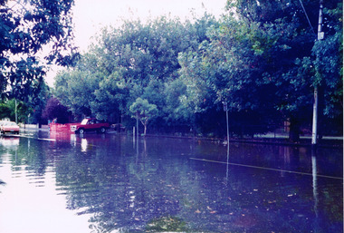
Photograph, Elwood floods 1989 - images collection, 7/02/1989
... Road...Floods...Glenhuntly Road floods Feb 89...St Kilda Historical Society St Kilda Branch Library 150 Carlisle Street St Kilda melbourne Glenhuntly Rd floods, February 1989 Glenhuntly Road Floods 1989 Elwood College Elwood Secondary College Elwood Glenhuntly Road floods Feb 89 colour photograph unmounted Elwood floods 1989 - images collection Photograph ...Glenhuntly Rd floods, February 1989colour photograph unmountedGlenhuntly Road floods Feb 89glenhuntly road, floods, 1989, elwood college, elwood secondary college, elwood -
 Kew Historical Society Inc
Photograph - Yarra Valley Floods: Kew East, 1916
... ...floods -- kew...kilby road...Flooding of the Yarra Valley at East Kew in 1916. The view is taken from the intersection of Kilby Road with what is believed to be Birdwood Street, looking across the flood waters to Ivanhoe. ...Verso: "Floods along Kilby Road / near Birdwood St? & Kilby Road / 1917? ...One of a collection of photographs of flooding in the Kew section of the Yarra Valley which are in important research resource for the location and extent of flooding in the first half of the twentieth century. yarra river yarra valley floods -- kew kilby road -- kew (vic.) kew golf club Verso: "Floods along Kilby Road / near Birdwood St? ...Flooding of the Yarra Valley, including that section of the Yarra bordering Kew and Kew East in the north and west of the municipality, was a regular occurrence. Extreme flood events of the Yarra River are recorded to have occurred in 1891, 1901, 1916, 1923 and 1934. The Municipality of Kew's response to these floods was to enact planning decisions restricting residential development in flood prone areas following the floods of 1916, 1921 and 1934. While floods continued after the development of the Upper Yarra Reservoir (construction 1948-57), the regularity and extent of these inundations diminished. During the nineteenth century, the land abutting the south side of the Yarra in Kew was devoted to dairy farming. In the twentieth century, before and after the construction of the Eastern Freeway, much of this low-lying area was used as golf courses and public parks.One of a collection of photographs of flooding in the Kew section of the Yarra Valley which are in important research resource for the location and extent of flooding in the first half of the twentieth century. Flooding of the Yarra Valley at East Kew in 1916. The view is taken from the intersection of Kilby Road with what is believed to be Birdwood Street, looking across the flood waters to Ivanhoe. The extensive flooded area shown in the photograph would have included the Kew Golf Club. Verso: "Floods along Kilby Road / near Birdwood St? & Kilby Road / 1917? / 87yarra river, yarra valley, floods -- kew, kilby road -- kew (vic.), kew golf club -
 Charlton Golden Grains Museum Inc
Photograph, 1970's Flood
... floods...St Arnaud Road Charlton...Landscape photo - 1970's flood - St Arnaud Road, Charlton Vic. 3525 -just out of town...1970 floods St Arnaud Road Charlton Landscape photo - 1970's flood - St Arnaud Road, Charlton Vic. 3525 -just out of town 1970's Flood Photograph ...Landscape photo - 1970's flood - St Arnaud Road, Charlton Vic. 3525 -just out of town1970 floods, st arnaud road charlton -
 Kew Historical Society Inc
Photograph - River Yarra in Flood from Kilby Road
... River Yarra in Flood from Kilby Road...Road...Floods -- Kew (Vic.)...Print copy of an original photo of the River Yarra in Flood, taken from Kilby Road....Kilby farm VIEW ACROSS YARRA IN FLOOD / FROM KILBY RD KEW Print copy of an original photo of the River Yarra in Flood, taken from Kilby Road. Photograph River Yarra in Flood from Kilby Road ...Flooding of the Yarra Valley, including that section of the Yarra bordering Kew and Kew East in the north and west of the municipality, was a regular occurrence. Extreme flood events of the Yarra River are recorded to have occurred in 1891, 1901, 1916, 1923 and 1934. The Municipality of Kew's response to these floods was to enact planning decisions restricting residential development in flood prone areas following the floods of 1916, 1921 and 1934. While floods continued after the development of the Upper Yarra Reservoir (construction 1948-57), the regularity and extent of these inundations diminished.Print copy of an original photo of the River Yarra in Flood, taken from Kilby Road.VIEW ACROSS YARRA IN FLOOD / FROM KILBY RD KEWkilby road, floods -- kew (vic.), kilby farm -
 Kew Historical Society Inc
Photograph - Flooding, Kilby Road, Kew, Ron Setford, 1974
... ...Floods -- Kew (Vic.)...Kilby Road..."Flood Kilby Road / May 74"... -- Kew (Vic.) Kilby Road -- Kew (Vic.) "Flood Kilby Road / May 74" Photograph Flooding, Kilby Road, Kew Ron Setford ...Ron Setford and his wife Grace Setford lived in Tanner Avenue, East Kew, from c.1946 to c.1995. A keen photographer, he recorded the changing face of Kew over a 20 year period. Apart from 30 photographs of built structures and places in Kew dating from 1960 and 1961, 145 of his 35mm colour slides chronicle the development of the Eastern Freeway through the Yarra Valley over a five year period from c.1972 to c.1977. This important collection was donated to the Society by his granddaughter in 2025.This collection of 175 35mm slides is of local and statewide significance, owing to its subject matter, particularly the major development of road transport infrastructure during the 1970s with the construction of the Eastern Freeway. The photographer also took care to annotate and date most of his slides which enable the researcher to pinpoint temporal and spatial locations."Flood Kilby Road / May 74"ron setford, floods -- kew (vic.), kilby road -- kew (vic.) -
 Charlton Golden Grains Museum Inc
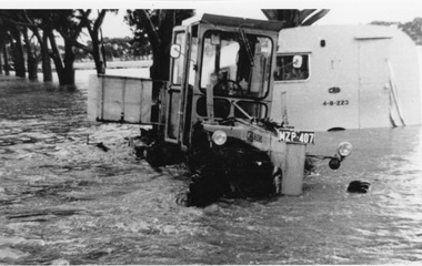
Photograph, Cameron, Ian, c.1973
... CRB grader towing a caravan 1973 Flood - washed off road before Yeungroon turnoff in 1973 flood....B/W photograph CRB grader towing a caravan 1973 Flood - washed off road before Yeungroon turnoff in 1973 flood...Charlton Golden Grains Museum Inc 1 High Street Charlton goldfields CRB grader towing a caravan 1973 Flood - washed off road before Yeungroon turnoff in 1973 flood. ...CRB grader towing a caravan 1973 Flood - washed off road before Yeungroon turnoff in 1973 flood.B/W photograph CRB grader towing a caravan 1973 Flood - washed off road before Yeungroon turnoff in 1973 floodcalder highway, yeungroon, floods -
 Eltham District Historical Society Inc
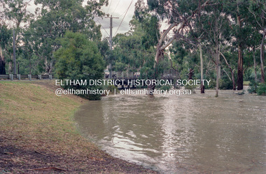
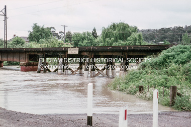
Photograph, Kangaroo Ground-Warrandyte Road, Kangaroo Ground, c.1988, 1988c
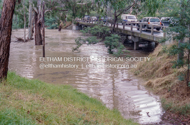
... Looking southeast, Floods Road on right adjacent to bus stop....Eltham District Historical Society Inc 728 Main Rd Eltham melbourne Looking southeast, Floods Road on right adjacent to bus stop. eltham shire council infrastructure kangaroo ground-warrandyte road Kangaroo Ground Fuji 100 Roll of 35mm colour negative film, 7 strips Kangaroo Ground-Warrandyte Road, Kangaroo Ground, c.1988 Photograph ...Looking southeast, Floods Road on right adjacent to bus stop.Roll of 35mm colour negative film, 7 stripsFuji 100eltham shire council, infrastructure, kangaroo ground-warrandyte road, kangaroo ground -
 Port of Echuca
A black and white postcard, 1906. or. 1916
... floods...goulburn road...A black and white postcard showing Goulburn Road, Echuca East, in either the 1906, or 1916 floods....Floodwaters cover the whole view. floods goulburn road echuca east pullicino, j postcard southern cross channel water filtration plant Printed on the back are the words; W. ...The postcard is significant because it shows the extent of the flood in the early 20th Century. The bridge crosses the Southern Cross channel which had been built as part of the Murray Darling irrigation system. There is a vehicle on the bridge either being towed by bullocks or horses. Floodwaters cover the whole view.The postcard is significant because it shows the extent of the flood in the early 20th Century. The bridge crosses the Southern Cross channel which had been built as part of the Murray Darling irrigation system. It is also near the water filtration plant which filters the town's water supply. There is a vehicle on the bridge either being towed by bullocks or horses. Floodwaters cover the whole view.A black and white postcard showing Goulburn Road, Echuca East, in either the 1906, or 1916 floods.Printed on the back are the words; W. Grimwood Echuca. POST CARD. Correspondence Address Only Kodak Australia. Hand written on the back are the words 1906 or 1916? Southern Cross bridge near filtration plant. Goulburn Road, Echuca East.floods, goulburn road, echuca east, pullicino, j, postcard, southern cross channel, water filtration plant -
 Eltham District Historical Society Inc
Album - Photograph, J.A. McDonald, Dixons Creek Road, 23 Sep. 1955
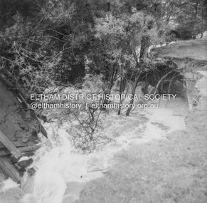
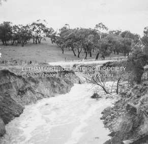
... Road...Flood damage...McDonald. 1955-09-23 bridge construction Dixons Creek Bridge Dixon's Creek Road Flood damage floods Infrastructure Road construction shire of eltham Black and white photo print (location of negative unknown) Adhered to a page in an album of 78 foolscap pages containing a sequence of photos, adhered via glue or sticky tape, with typed or handwritten headings and captions in pencil. ...Dixons Creek in floodRecord of various Shire of Eltham infrastructure works undertaken during the period of 1952-1962 involving bridge and road reconstruction projects, sometimes with Eltham Shire Council Project Reference numbers quoted. It was during this period that a number of significant improvements were made to roads and new bridges constructed within the shire that remain in place as of present day (2022). In many situations, the photos provide a tangible visible record of infrastructure that existed throughout the early days of the Shire. The album was put together by or under the direction of the Shire Engineer, J.A. McDonald.1955-09-23, bridge construction, dixons creek bridge, dixon's creek road, flood damage, floods, infrastructure, road construction, shire of eltham -
 Eltham District Historical Society Inc
Album - Photograph, J.A. McDonald, Dixons Creek Road, 23 Sep. 1955
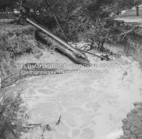
... Road...Flood damage...McDonald. 1955-09-23 bridge construction Dixons Creek Bridge Dixon's Creek Road Flood damage floods Infrastructure Road construction shire of eltham Black and white photo print (location of negative unknown) Adhered to a page in an album of 78 foolscap pages containing a sequence of photos, adhered via glue or sticky tape, with typed or handwritten headings and captions in pencil. ...Dixons Creek in flood Temporary bridge washed outRecord of various Shire of Eltham infrastructure works undertaken during the period of 1952-1962 involving bridge and road reconstruction projects, sometimes with Eltham Shire Council Project Reference numbers quoted. It was during this period that a number of significant improvements were made to roads and new bridges constructed within the shire that remain in place as of present day (2022). In many situations, the photos provide a tangible visible record of infrastructure that existed throughout the early days of the Shire. The album was put together by or under the direction of the Shire Engineer, J.A. McDonald.1955-09-23, bridge construction, dixons creek bridge, dixon's creek road, flood damage, floods, infrastructure, road construction, shire of eltham -
 Eltham District Historical Society Inc
Photograph, Grace Mitchell, Diamond Creek in flood, Bremners Flat, Main Road, Eltham, c.1958
... Diamond Creek in flood, Bremners Flat, Main Road, Eltham...floods...Main Road...Bremner's Flat Diamond Creek floods Main Road Mount Pleasant Road wingrove park Black and white print 17 x 25.4 cm Diamond Creek in flood, Bremners Flat, Main Road, Eltham Photograph Photograph Grace Mitchell ...View from Grace Mitchell's shop at the corner of Mount Pleasant Road and Main Road. Grace Mitchell was probably best known for her Eltham shop at the corner of Mt Pleasant Road and Main Road. Grace's memories covered many local identities who were patrons of her shop between 1954 and 1971. From the elevated position of her shop and home Grace was able to view a varied passing parade of Eltham events from ERSILAC, Easter and Eltham Festival parades passing on their way to Eltham Lower Park, circuses in Wingrove Park (then Bremner’s Reserve), roadworks and other happenings. Bremner's Reserve was renamed Wingrove Park c.1970 This photo was from a series of images presented by Grace Mitchell at a Society talk 10 March 1993 on the theme of “My Eltham”.Black and white print 17 x 25.4 cmbremner's flat, diamond creek, floods, main road, mount pleasant road, wingrove park -
 Eltham District Historical Society Inc
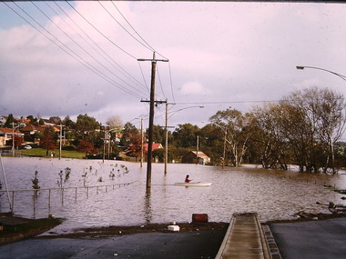
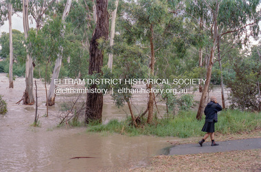
Negative - Photograph, Diamond Creek floodwaters near Main Road Bridge, Eltham, Feb. 2005
... floods...Main Road...Eltham District Historical Society Inc 728 Main Rd Eltham melbourne Flooding of the Diamond Creek in February 2005 Bridge Diamond Creek (Creek) Eltham Eltham South floods Main Road main road bridge Kodak GC400-8 Roll of 35mm colour negative film, 7 strips Associated colour print 10 x 15 cm Diamond Creek floodwaters near Main Road Bridge, Eltham Negative Photograph ...Flooding of the Diamond Creek in February 2005Roll of 35mm colour negative film, 7 strips Associated colour print 10 x 15 cmKodak GC400-8bridge, diamond creek (creek), eltham, eltham south, floods, main road, main road bridge -
 Eltham District Historical Society Inc
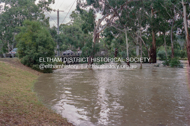
Photograph, Diamond Creek floodwaters near the Main Road Bridge, Eltham, Jan-Feb 2005, 2005
... floods...main road bridge...Eltham District Historical Society Inc 728 Main Rd Eltham melbourne diamond creek eltham floods main road bridge Kodak GC400-8 Roll of 35mm colour negative film, 7 strips Diamond Creek floodwaters near the Main Road Bridge, Eltham, Jan-Feb 2005 Photograph Photograph ...Roll of 35mm colour negative film, 7 stripsKodak GC400-8diamond creek, eltham, floods, main road bridge -
 Eltham District Historical Society Inc
Negative - Photograph, Diamond Creek floodwaters near Main Road Bridge, Eltham, Feb. 2005
... floods...Main Road...Eltham District Historical Society Inc 728 Main Rd Eltham melbourne Flooding of the Diamond Creek in February 2005 Bridge Diamond Creek (Creek) Eltham Eltham South floods Main Road main road bridge Kodak GC400-8 Roll of 35mm colour negative film, 7 strips Associated colour print 10 x 15 cm Diamond Creek floodwaters near Main Road Bridge, Eltham Negative Photograph ...Flooding of the Diamond Creek in February 2005Roll of 35mm colour negative film, 7 strips Associated colour print 10 x 15 cmKodak GC400-8bridge, diamond creek (creek), eltham, eltham south, floods, main road, main road bridge -
 Eltham District Historical Society Inc
Photograph, Diamond Creek floodwaters near the Main Road Bridge, Eltham, Jan-Feb 2005, 2005
... floods...main road bridge...Eltham District Historical Society Inc 728 Main Rd Eltham melbourne diamond creek eltham floods main road bridge Kodak GC400-8 Roll of 35mm colour negative film, 7 strips Diamond Creek floodwaters near the Main Road Bridge, Eltham, Jan-Feb 2005 Photograph Photograph ...Roll of 35mm colour negative film, 7 stripsKodak GC400-8diamond creek, eltham, floods, main road bridge -
 Eltham District Historical Society Inc
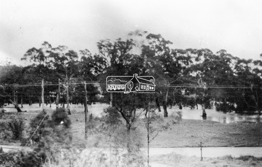
Slide, Floodwater near the Skipper house at Main Road and Dalton Street, Eltham, November 1971, 1971
... Dalton Street, Eltham, floods, Main Road, Skipper House...Eltham District Historical Society Inc 728 Main Rd Eltham melbourne Dalton Street, Eltham, floods, Main Road, Skipper House 35 mm colour positive transparency Mount - Agfacolor Service (Blue) Floodwater near the Skipper house at Main Road and Dalton Street, Eltham, November 1971 Slide Slide ...35 mm colour positive transparency Mount - Agfacolor Service (Blue)dalton street, eltham, floods, main road, skipper house -
 Eltham District Historical Society Inc
Slide, Floodwater near the Skipper house at Main Road and Dalton Street, Eltham, November 1971, 1971
... dalton street, eltham, floods, main road, skipper house...Eltham District Historical Society Inc 728 Main Rd Eltham melbourne dalton street, eltham, floods, main road, skipper house 35 mm colour positive transparency Mount - Agfacolor Service (Blue) Floodwater near the Skipper house at Main Road and Dalton Street, Eltham, November 1971 Slide Slide ...35 mm colour positive transparency Mount - Agfacolor Service (Blue)dalton street, eltham, floods, main road, skipper house -
 Eltham District Historical Society Inc
Photograph - Slide, Floodwater, Railway Bridge across Railway Road, Briar Hill, Vic, November 1971
... Briar Hill, floods, Para Road, Railway Bridge...Eltham District Historical Society Inc 728 Main Rd Eltham melbourne Briar Hill, floods, Para Road, Railway Bridge 35 mm colour positive transparency Mount - Agfacolor Service (Blue) Floodwater, Railway Bridge across Railway Road, Briar Hill, Vic. ...35 mm colour positive transparency Mount - Agfacolor Service (Blue)briar hill, floods, para road, railway bridge -
 Eltham District Historical Society Inc
Slide, Floodwater, Para Road Bridge, Briar Hill, November 1971, 1971
... Briar Hill, floods, Para Road Bridge...Eltham District Historical Society Inc 728 Main Rd Eltham melbourne Briar Hill, floods, Para Road Bridge 35 mm colour positive transparency Mount - Agfacolor Service (Blue) Floodwater, Para Road Bridge, Briar Hill, November 1971 Slide Slide ...35 mm colour positive transparency Mount - Agfacolor Service (Blue)briar hill, floods, para road bridge -
 Eltham District Historical Society Inc
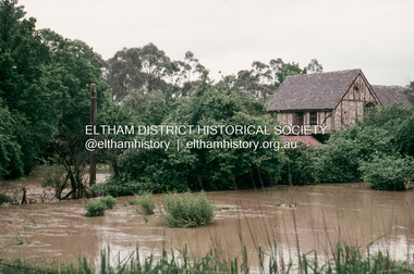
Photograph, Main Road, Eltham South, near Eltham Park, flooded by the Diamond Creek, 30 Nov. 1934
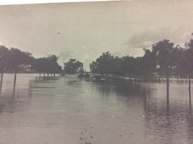
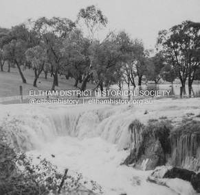
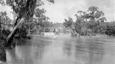
... floods...main road...road. All the week-end shops are surrounded. For over 40 years flood waters have not reached this unprecedented level.” - Advertiser, Friday November 30, 1934, p7 "Whilst we were at the shop a "tidal" wave occured . ..." (Doug Orford Reminiscences, 2004) The 1934 flood of the Diamond Creek and Yarra River is the highest recorded flooding in the district and set the standard for the current planning flood plain level. floods main road eltham south Diamond Creek (Creek) Wingrove Cottage wingrove park Bus Services Bremner's Flat Eltham Park Ford Wagonette Mr. ...Near Eltham Park (now known as Eltham Lower Park), floodwaters from the Diamond Creek cut off the Main road into Eltham at Bremner’s Flats (present day Wingrove Park). In the distance, left of centre, is Mr. Montieth's Ford Wagonette stranded in the floodwater near Wingrove Cottage. “On the Lower Eltham Reserve the water was nearly five feet deep across the reserve and over a mile along the road. All the week-end shops are surrounded. For over 40 years flood waters have not reached this unprecedented level.” - Advertiser, Friday November 30, 1934, p7 "Whilst we were at the shop a "tidal" wave occured . There used to be a Mr. Monteith who ran a Model T Ford bus from the Eltham Railway Station down the main street. The bus would hold seven, six seated in the back, 3 aside a seventh standing on the step on the middle of the back hanging on to two small hand rails. The bus was caught by the flood and was abandoned not far from our shop in the paddocks towards the Higher Elementary School. It was there for days and after the flood waters receded, Mr. Monteith, after removing all the mud and debris gave the engine one turn with the handle and it started first time! So the story goes! " (Doug Orford Reminiscences, 2004) The 1934 flood of the Diamond Creek and Yarra River is the highest recorded flooding in the district and set the standard for the current planning flood plain level.Black and white photograph showing the floodwater from Diamond Creek across Main Road in 1934. Left of centre shows Mr. Montieth's Ford Wagonette in the floodwater in the distancefloods, main road, eltham south, diamond creek (creek), wingrove cottage, wingrove park, bus services, bremner's flat, eltham park, ford wagonette, mr. montieth, floodwater, reminscences -
 Eltham District Historical Society Inc
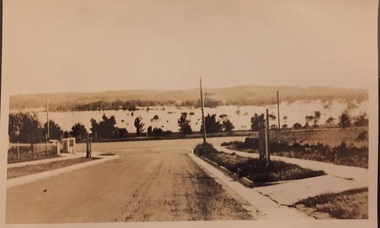
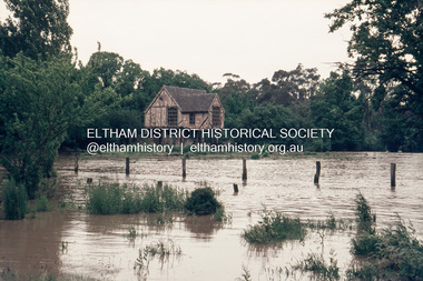
Photograph, Eltham - Floods in 1934
... Flood...Diamond Creek...floods...main road...To the left of picture is the Main Road Bridge over the Diamond Creek in Eltham South when the Diamond Creek was in flood. ...It is significant in being the first community sourced collection representing the places and people of the Shire's first one hundred years. sepp shire of eltham pioneers photograph collection eltham diamond creek (river) 1934 Flood Diamond Creek floods main road bridge Digital image 4 x 5 inch B&W Neg Eltham - Floods in 1934 Photograph Photograph ...To the left of picture is the Main Road Bridge over the Diamond Creek in Eltham South when the Diamond Creek was in flood. The Yarra also was in flood. In early December 1934 the "Greatest flood in the history of the Yarra" occured, according to The Argus newspaper. Bridges and houses were swept away with hundreds of people left homeless across the state. The historic 1934 flood of the Diamond Creek and Yarra River set the criteria for future planning with respect to flood water rise.This photo forms part of a collection of photographs gathered by the Shire of Eltham for their centenary project book, "Pioneers and Painters: 100 years of the Shire of Eltham" by Alan Marshall (1971). The collection of over 500 images is held in partnership between Eltham District Historical Society and Yarra Plenty Regional Library (Eltham Library) and is now formally known as 'The Shire of Eltham Pioneers Photograph Collection.' It is significant in being the first community sourced collection representing the places and people of the Shire's first one hundred years.Digital image 4 x 5 inch B&W Negsepp, shire of eltham pioneers photograph collection, eltham, diamond creek (river), 1934 flood, diamond creek, floods, main road bridge -
 Lakes Entrance Historical Society
Photograph - Bridges, Bunga Creek- rustic footbridge Lakes Entrance Victoria, 1910
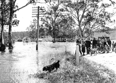
... It shows a rustic footbridge over waterway beside flooded road, horse and buggy with man and woman on board at edge of water. ...It shows a rustic footbridge over waterway beside flooded road, horse and buggy with man and woman on board at edge of water. ...Also black and white identical copy 10 x 15 cm, donated by Marion Holding. 02288.1Sepia toned photograph of the old road crossing at Bunga Creek, between Lake Tyers and Lakes Entrance. It shows a rustic footbridge over waterway beside flooded road, horse and buggy with man and woman on board at edge of water. Lakes Entrance Victoriabridges, waterways -
 Kiewa Valley Historical Society
Photos - x2 Damms Road River Crossing
... Damms Road river crossing after the c1993 floods of the Kiewa River. ...2 coloured photos of the Kiewa River in flood at Damms Road...Kiewa River flooding Bridge at Damms Road 2 coloured photos of the Kiewa River in flood at Damms Road Photos - x2 Damms Road River Crossing ...Damms Road river crossing after the c1993 floods of the Kiewa River. The old bridge was inundated, later to be washed away.The Kiewa River flooded in 1993 at Damms Road when the old bridge was washed away.2 coloured photos of the Kiewa River in flood at Damms Roadkiewa river flooding, bridge at damms road