
Showing 5 items matching "following the fence line"
-
 Eltham District Historical Society Inc
Document - Folder, Woodburn, Bettina
... ...Following the Fence Line...Bettina Woodburn Veteran Athletic Club of Victoria World Veterans' Games Stirling Silver Cross Country Skiing competition Edendale Farm Diamond Creek Cemetery Murray Road Wattle Glen Police Station Hurstbridge Allwood House Hurstbridge Arthurs Creek Road Monash bridge St Peter's Church Hurstbridge Maud Rattray Kangaroo Ground Lookout Tower Wellers Pub Kangaroo Ground Aqueduct Maroondah Dam Bill Woodburn Betti Woodburn Woodburn House David Bick Mainstreaming the Message Following the Fence Line Diamond Valley Living and Learning Centre La Trobe University Deakin University Whroo Chateau Tahbilk Bettina Mathilde Woodburn nee Bromley Harcourt Bromley Mathilda Bromley Newspaper clippings, A4 photocopies, etc Woodburn, Bettina Document Folder ...Montmorency resident Bettina Woodburn took up many physical challenges in later life. Contents Newspaper article: "Late start hasn't hindered Bettina", Diamond Valley News, 26 August 1986. Newsletter article: "Eltham Cultural Heritage Tour 1992", Reprinted from Eltham District Historical Society no.85. Bettina Woodburn's notes on a driving/walking tour of the district's cultural heritage, guided by David Bick in 1992. Newspaper article: "The challenge of the Murray", Diamond Valley News, 20 May 1998. Bettina Woodburn was part of a team of women who paddled the Murray River in aid of breast cancer research. Report, Bettina Woodburn, 9 October 1994, on Eltham District Historical Society expedition to Whroo and Chateau Tahbilk. Newspaper page, no title, no date: Photograph of Bettina Woodburn. Newspaper notice: Death notice for Bettina Mathilde Woodburn.Newspaper clippings, A4 photocopies, etcbettina woodburn, veteran athletic club of victoria, world veterans' games, stirling silver cross country skiing competition, edendale farm, diamond creek cemetery, murray road wattle glen, police station hurstbridge, allwood house hurstbridge, arthurs creek road monash bridge, st peter's church hurstbridge, maud rattray, kangaroo ground lookout tower, wellers pub kangaroo ground, aqueduct maroondah dam, bill woodburn, betti woodburn, woodburn house, david bick, mainstreaming the message, following the fence line, diamond valley living and learning centre, la trobe university, deakin university, whroo, chateau tahbilk, bettina mathilde woodburn nee bromley, harcourt bromley, mathilda bromley -
 Ringwood and District Historical Society
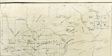
Map - Public Land Sale by Thomas Ham, 2000 Acres for Sale - Crown Sections 20, 23, 24 - Ringwood, Victoria - 1855
... following directions, viz: Start from Richmond Bridge, at Hawthorne, then take the left-hand road to KEW. When at the "Woodman Inn", take the Cotham Road to the right, bearing due east, keep this Road, passing Trainor's "White Horse" Inn, and before you leave the fences, you will see calico bills (see margin) nailed to the Trees on the bush track leading to the Upper Yarra country, follow the Bills till you come to the SOUTH boundary line of the Property, which bears East and West (see Plan) where you will see Bills nailed up "THIS PROPERTY FOR SALE, etc." ...following directions, viz: Start from Richmond Bridge, at Hawthorne, then take the left-hand road to KEW. When at the "Woodman Inn", take the Cotham Road to the right, bearing due east, keep this Road, passing Trainor's "White Horse" Inn, and before you leave the fences, you will see calico bills (see margin) nailed to the Trees on the bush track leading to the Upper Yarra country, follow the Bills till you come to the SOUTH boundary line of the Property, which bears East and West (see Plan) where you will see Bills nailed up "THIS PROPERTY FOR SALE, etc." ...Two 1850s surveyor's maps on cardboard backing showing area from Melbourne extending East beyond Bulleen and Nunawading. Detailed description of lots for sale and navigational directions to the property from Richmond by Thomas Ham, Victorian public servant, map maker, publisher, lithographer and original Ringwood land owner. Inset map enlarging area between Yarra River and Dandenong Creek, with southern boundary of allotments later forming part of Oban Road, North Ringwood.TRANSCRIPT: "This really valuable Property is now offered to the public for sale, in lots to suit purchasers at the Iow rate of £1 per Acre for 80 acres and upwards, and £1.10s per Acre for any smaller portion. Terms of payment Half Cash, Balance in 6 and 12 months, bearing 8 per cent interest. The Estate is well wooded with Gum, Cherry Tree and Stringy Bark, with Wattle in the valleys of the several creeks. Every lot is Staked and Trenched at the corners marked on the Plan thus - The Surveyor has carefully sub-divided the Property, in order to give every Farm a Creek for Water, Valley for Cultivation, and Hills for House and Grass Paddock. The ROADS have been very carefully laid out so as to give a firm, well drained, and nearly level road to each Homestead. Intending purchasers can readily find the property by the following directions, viz: Start from Richmond Bridge, at Hawthorne, then take the left-hand road to KEW. When at the "Woodman Inn", take the Cotham Road to the right, bearing due east, keep this Road, passing Trainor's "White Horse" Inn, and before you leave the fences, you will see calico bills (see margin) nailed to the Trees on the bush track leading to the Upper Yarra country, follow the Bills till you come to the SOUTH boundary line of the Property, which bears East and West (see Plan) where you will see Bills nailed up "THIS PROPERTY FOR SALE, etc." The Bills from Town lead direct to where Mr. Jull is erecting his Store, and arrangements have been made with him to show the lots to intending purchasers free of charge. At the respective corners of the lots the Bills are nailed up double, with numbers to denote the lot, and that the corner stake is adjacent. Any parties wishing to proceed to the property by way of BULLEEN will find Bills nailed on the Trees, commencing at the NEW INN, at "Wilson's Slip Rail." Keep this Track till you come to the Log Bridge, over the Deep Creek at Bloxhome's Paddock; go through the land now being cleared; keep the track over the hill till you come to an Iron House, you will then be on the property, which Iies to the North and East as per Plan. Follow the Bills till you come to Mr. Jull's Store, etc. etc. Further particulars can be had from the Agent for the Property. THOMAS HAM. " -
 Flagstaff Hill Maritime Museum and Village
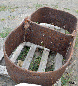
Mast Collar, c. 1886
... fence line. The motel owner told his guest the story of a customer, a doctor, who had organised and paid for divers to raise the mast collar from a local shipwreck, the Falls of Halladale. Shortly afterwards the doctor passed away, so the mast collar had remained at the motel site. The owner was leaving the motel the following...fence line. The motel owner told his guest the story of a customer, a doctor, who had organised and paid for divers to raise the mast collar from a local shipwreck, the Falls of Halladale. Shortly afterwards the doctor passed away, so the mast collar had remained at the motel site. The owner was leaving the motel the following ...The husband of the donor of this mast collar chanced to be staying a night at a motel in Peterborough, along the Great Ocean Road in Victoria. He had a keen interest in maritime items and recognise the mast collar at the motel’s back fence line. The motel owner told his guest the story of a customer, a doctor, who had organised and paid for divers to raise the mast collar from a local shipwreck, the Falls of Halladale. Shortly afterwards the doctor passed away, so the mast collar had remained at the motel site. The owner was leaving the motel the following week and wasn’t at all interested in the artefact. He was very happy for his guest to remove it. It took five men to load the mast collar up for the trip to the new owner’s two storey shed in Ballarat. It stayed there undercover, in the company of his collection of 5 buggies, for the next 40 or so years until the property was for sale. A friend, who realised the significance of the mast collar, suggested that it be donated to Flagstaff Hill Maritime Village where other artefacts from the Falls of Halladale, such as the slate tiles, were on display. This mast collar, or masthead, from the Falls of Halladale would have been used to join two sections of one of the tall masts. As sailing ships became larger there was a need for taller masts or spars, which became difficult or impossible to find. To overcome this problem mast was divided into sections; lower and top or upper mast (on some of the ‘tall ships’ a mast could be divided into three or even four sections). The Falls of Halladale was a four-masted British barque built-in 1886. On what turned out to be her fatal journey, she had left New York for Melbourne in late 1908. She ran aground on a reef close to the shore west of Peterborough, South West Victoria, on November 14th. All 29 crew eventually landed safely onshore. The wrecked ship stayed on the reef for several months as locals watched the sails slowly deteriorate. The salvaged cargo included slate tiles, as mentioned above, and many of these have been used on the roof of buildings at the Flagstaff Hill Maritime Village. The iron-hulled, four-masted barque, the Falls of Halladale, was a bulk carrier of general cargo. She left New York in August 1908 on her way to Melbourne and Sydney. In her hold, along with 56,763 tiles of unusual beautiful green American slates (roofing tiles), 5,673 coils of barbed wire, 600 stoves, 500 sewing machines, 6500 gallons of oil, 14400 gallons of benzene, and many other manufactured items, were 117 cases of crockery and glassware. Three months later and close to her destination, a navigational error caused the Falls of Halladale to be wrecked on a reef off the Peterborough headland at 3 am on the morning of the 15th of November, 1908. The captain and 29 crew members all survived, but her valuable cargo was largely lost, despite two salvage attempts in 1908-09 and 1910. ABOUT THE ‘FALLS OF HALLADALE’ (1886 - 1908) Built: in1886 by Russell & Co., Greenock shipyards, River Clyde, Scotland, UK. The company was founded in 1870 (or 1873) as a partnership between Joseph Russell (1834-1917), Anderson Rodger and William Todd Lithgow. During the period 1882-92 Russell & Co., standardised designs, which sped up their building process so much that they were able to build 271 ships over that time. In 1886 they introduced a 3000 ton class of sailing vessel with auxiliary engines and brace halyard winches. In 1890 they broke the world output record. Owner: Falls Line, Wright, Breakenridge & Co, 111 Union Street, Glasgow, Scotland. Configuration: Four masted sailing ship; iron-hulled barque; iron masts, wire rigging, fore & aft lifting bridges. Size: Length 83.87m x Breadth 12.6m x Depth 7.23m, Gross tonnage 2085 ton Wrecked: the night of 14th November 1908, Curdies Inlet, Peterborough south west Victoria Crew: 29 The Falls of Halladale was a four-masted sailing ship built-in 1886 in Glasgow, Scotland, for the long-distance cargo trade and was mostly used for Pacific grain trade. She was owned by Wright, Breakenridge & Co of Glasgow and was one of several Falls Line ships, all of which were named after waterfalls in Scotland. The lines flag was of red, blue and white vertical stripes. The Falls of Halladale had a sturdy construction built to carry maximum cargo and able to maintain full sail in heavy gales, one of the last of the ‘windjammers’ that sailed the Trade Route. She and her sister ship, the Falls of Garry, were the first ships in the world to include fore and aft lifting bridges. Previous to this, heavily loaded vessels could have heavy seas break along the full length of the deck, causing serious injury or even death to those on deck. The new, raised catwalk-type decking allowed the crew to move above the deck stormy conditions. This idea is still used today on the most modern tankers and cargo vessels and has proved to be an important step forward in the safety of men at sea. On 4th August 1908, with new sails, 29 crew, and 2800 tons of cargo, the Falls of Halladale left New York, bound for Melbourne and Sydney via the Cape of Good Hope. The cargo on board was valued at £35,000 and included 56,763 tiles of American slate roofing tiles (roof slates), 5,673 coils of barbed wire, 600 stoves, 500 sewing machines, 6,500 gallons of oil, 14,400 gallons of benzene, plumbing iron, 117 cases of crockery and glassware and many other manufactured items. The Falls of Halladale had been at sail for 102 days when, at 3 am on the night of 14th November 1908, under full sail in calm seas with a six knots breeze behind and misleading fog along the coast, the great vessel rose upon an ocean swell and settled on top of a submerged reef near Peterborough on the south-west Victoria’s coast. The ship was jammed on the rocks and began filling with water. The crew launched the two lifeboats and all 29 crew landed safely on the beach over 4 miles away at the Bay of Islands. The postmistress at Peterborough, who kept a watch for vessels in distress, saw the stranding and sent out an alert to the local people. A rescue party went to the aid of the sailors and the Port Campbell rocket crew was dispatched, but the crew had all managed to reach shore safely by the time help arrived. The ship stayed in full sail on the rocky shelf for nearly two months, attracting hundreds of sightseers who watched her slowly disintegrate until the pounding seas and dynamiting by salvagers finally broke her back, and her remains disappeared back into deeper water. The valuable cargo was largely lost, despite two salvage attempts in 1908-09 and 1910. Further salvage operations were made from 1974-1986, during which time 22,000 slate tiles were recovered with the help of 14 oil drums to float them, plus personal artefacts, ship fittings, reams of paper and other items. The Court of Marine Inquiry in Melbourne ruled that the foundering of the ship was entirely due to Captain David Wood Thomson’s navigational error, not too technical failure of the Clyde-built ship. The shipwreck is a popular site for divers, about 300m offshore and in 3 – 15m of water. Some of the original cargo can be seen at the site, including pieces of roof slate and coils of barbed wire. This mast collar is significant due to its association with the ship FALLS OF HALLADALE, which is listed on the Victorian Heritage Register, VHR S255 The Falls of Halladale shipwreck is listed on the Victorian Heritage Register (No. S255). She was one of the last ships to sail the Trade Routes. She is one of the first vessels to have fore and aft lifting bridges. She is an example of the remains of an International Cargo Ship and also represents aspects of Victoria’s shipping industry. The wreck is protected as a Historic Shipwreck under the Commonwealth Historic Shipwrecks Act (1976). Mast collar, steel, salvaged from the shipwreck FALLS OF HALLADALE, wrecked off the coast of Peterborough, South West Victoria. Oval shaped a band of metal with a straight band of same heights attached between the long sides. Two metal loops are attached to the outside of the oval shape, next to the crossing band. flagstaff hill, warrnambool, shipwrecked coast, flagstaff hill maritime museum, maritime museum, shipwreck coast, flagstaff hill maritime village, great ocean road, falls of halladale, shipwreck peterborough vic, sailing ship mast collar, masthead of sailing ship, falls of halladale mast collar, masthead, mast collar, ship rigging 1908, russell & co. -
 Melbourne Tram Museum
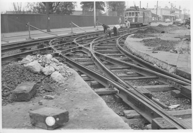
Photograph - New run out track Essendon Depot, Melbourne & Metropolitan Tramways Board MMTB or VicRail or Ministry of Transport, Sept 1960
... fence and tennis court opposite the depot are part of a Catholic convent and teachers college. Records suggest the date is September 1960 when the single northern exit/entry track to the southbound line was replaced with this double track. Until this time, a separate crossover provided a connection to the northbound line. This new arrangement meant that trams running out or in from the northbound track no longer had to negotiate a crossover, thus reducing motor traffic congestion. The obsolete crossover was removed. It is likely that in the following...fence and tennis court opposite the depot are part of a Catholic convent and teachers college. Records suggest the date is September 1960 when the single northern exit/entry track to the southbound line was replaced with this double track. Until this time, a separate crossover provided a connection to the northbound line. This new arrangement meant that trams running out or in from the northbound track no longer had to negotiate a crossover, thus reducing motor traffic congestion. The obsolete crossover was removed. It is likely that in the following ...Photograph shows the laying of a new northern exit/entry road for Essendon Depot. Grooved tramway rail and turnouts are in place supported by timber sleepers. Part of the footpath and a section roadway on Mt Alexander Road are excavated for these works. Three workmen in civilian clothes are tightening tie bars; W2 class tram 552 has cleared the new works bound for Essendon Aerodrome route 59 with weather blinds down; three motor vehicles are shown in the distance, two with the distinctive shape of a Holden. The high fence and tennis court opposite the depot are part of a Catholic convent and teachers college. Records suggest the date is September 1960 when the single northern exit/entry track to the southbound line was replaced with this double track. Until this time, a separate crossover provided a connection to the northbound line. This new arrangement meant that trams running out or in from the northbound track no longer had to negotiate a crossover, thus reducing motor traffic congestion. The obsolete crossover was removed. It is likely that in the following days mass concrete was used to rebuild the roadway. As tramway rail with a flangeway was no longer produced in Australia from the 1960s, railway-type rail without a flangeway was used instead and the flangeway provided by a groove in the concrete. This photograph is likely an official M&MTB photograph.Yields information about Essendon Depot and track improvements c1960 Black and white photographs with no note on rear. official m&mtb photograph, essendon depot, exit road, mt alexander road, tie bars, w2 class, 552, weather blinds, essendon aerodrome, route 59, holden, catholic convent, teachers college, crossover, turnout, mass concrete, railway type rail, flangeway -
 8th/13th Victorian Mounted Rifles Regimental Collection
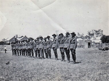
Photograph - 20 Light Horse group
... following the end of the war. 20th Light Horse was the only light horse regiment to serve overseas in WWII. This is one of a collection of photographs featuring a Light Horse regiment drawn from rural and regional Victoria in the period immediately prior to mobilisation for World War 2 (1939-1945). 20LH uniform Black and white photograph of single line of soldiers fallen-in in a vacant allotment surrounded by houses and fences. ...The 20th Light Horse (Victorian Mounted Rifles) was raised in 1920 as part of the 3rd Cavalry Brigade, 2nd Cavalry Division, Citizen Military Forces, with Headquarters at Seymour and depots along the Goulburn Valley from Mansfield to Tocumwal in southern NSW. In December 1941, 20th Light Horse (Victorian Mounted Rifles) converted from horse to mechanised, initially as 20th Motor Regiment. In 1943 the Regiment was deployed to Merauke, Dutch New Guinea. Upon its return in April 1945, the Regiment was redesignated 20th Pioneer Battalion. It was disbanded following the end of the war. 20th Light Horse was the only light horse regiment to serve overseas in WWII.This is one of a collection of photographs featuring a Light Horse regiment drawn from rural and regional Victoria in the period immediately prior to mobilisation for World War 2 (1939-1945).Black and white photograph of single line of soldiers fallen-in in a vacant allotment surrounded by houses and fences. Part of 20th Light Horse collection.20lh, uniform
