Bendigo Military Museum
Photograph - Army Survey Regiment Inter-Squadron Athletics Competition - Set 2, Bendigo, 1990
... Background L to R: John Reid, Stuart Thaxter, Geoff Webb.
.6) - Photo, colour, 1990, Relay Race, L to R: Terry King, Ian Fitzgerald.
.7) - Photo, colour, 1990, Relay Race, Bob Coote.
.8) - Photo, colour, 1990, officials conferring in foreground L to R: Ian Nelson, Fred Cowie, unidentified. Background L to R: Paul Richards, Brian Collings, Ian ‘Rock’ Thistleton.
.9) & .10) - Photo, colour, 1990, Peter Imerson.
.11) - Photo, colour, 1990, Wheelbarrow Race, L to R: Steve Hansen, Noel ‘Nesty’ Coulthard, Stuart Thaxter.
.12) - Photo, colour, 1990, Wheelbarrow Race, L to R: Ken ‘Sluggo’ Slater, Ray Redman, Steve Hansen, Noel ‘Nesty’ Coulthard, Stuart Thaxter, Steve Wegener, unidentified, Neil Taylor, Graham Ragless, Gary Warnest, Chris Wynn, Bill Jones, Marty Lyons, Rob Bogumil, Dave McLachlan.
.13) - Photo, colour, 1990, Wheelbarrow Race, L to R: Ken ‘Sluggo’ Slater, Steve Hledik, Bob Coote, Steve Hansen, unidentified, Bill Jones, Neil Taylor.
.14) - Photo, colour, 1990, Wheelbarrow Race, L to R: Marty Lyons, Rob Bogumil.
.15) - Photo, colour, 1990, Wheelbarrow Race, L to R: Neil Taylor, Graham Ragless, Ray Redman, Steve Hansen.
.16) - Photo, colour, 1990, Wheelbarrow Race, L to R: Bob Coote, Neil Taylor, Graham Ragless, Gary Warnest, Marty Lyons, Rob Bogumil, Dave McLachlan, Bill Jones.
.17) - Photo, colour, 1990, Wheelbarrow Race, L to R: Bob Coote, Bill Jones.
.18) - Photo, colour, 1990, Wheelbarrow Race, L to R: Gary Warnest, Terry Lord, Stuart Thaxter, Noel ‘Nesty’ Coulthard.
.19) - Photo, colour, 1990, teams prepare for Tunnelball event. ...Background L to R: John Reid, Stuart Thaxter, Geoff Webb.
.6) - Photo, colour, 1990, Relay Race, L to R: Terry King, Ian Fitzgerald.
.7) - Photo, colour, 1990, Relay Race, Bob Coote.
.8) - Photo, colour, 1990, officials conferring in foreground L to R: Ian Nelson, Fred Cowie, unidentified. Background L to R: Paul Richards, Brian Collings, Ian ‘Rock’ Thistleton.
.9) & .10) - Photo, colour, 1990, Peter Imerson.
.11) - Photo, colour, 1990, Wheelbarrow Race, L to R: Steve Hansen, Noel ‘Nesty’ Coulthard, Stuart Thaxter.
.12) - Photo, colour, 1990, Wheelbarrow Race, L to R: Ken ‘Sluggo’ Slater, Ray Redman, Steve Hansen, Noel ‘Nesty’ Coulthard, Stuart Thaxter, Steve Wegener, unidentified, Neil Taylor, Graham Ragless, Gary Warnest, Chris Wynn, Bill Jones, Marty Lyons, Rob Bogumil, Dave McLachlan.
.13) - Photo, colour, 1990, Wheelbarrow Race, L to R: Ken ‘Sluggo’ Slater, Steve Hledik, Bob Coote, Steve Hansen, unidentified, Bill Jones, Neil Taylor.
.14) - Photo, colour, 1990, Wheelbarrow Race, L to R: Marty Lyons, Rob Bogumil.
.15) - Photo, colour, 1990, Wheelbarrow Race, L to R: Neil Taylor, Graham Ragless, Ray Redman, Steve Hansen.
.16) - Photo, colour, 1990, Wheelbarrow Race, L to R: Bob Coote, Neil Taylor, Graham Ragless, Gary Warnest, Marty Lyons, Rob Bogumil, Dave McLachlan, Bill Jones.
.17) - Photo, colour, 1990, Wheelbarrow Race, L to R: Bob Coote, Bill Jones.
.18) - Photo, colour, 1990, Wheelbarrow Race, L to R: Gary Warnest, Terry Lord, Stuart Thaxter, Noel ‘Nesty’ Coulthard.
.19) - Photo, colour, 1990, teams prepare for Tunnelball event. ...
This is a set of 30 photographs of an Army Survey Regiment inter-squadron athletics competition held at Epsom, Bendigo in 1990. Personnel from Headquarters, Air Survey, Cartographic and Lithographic Squadrons took part in traditional athletics events, wheelbarrow race, sack race, fireman’s carry and tug-of-war novelty events.’ Air Survey Squadron’s team was bolstered with members from Adelaide’s 4th Field Survey Squadron. Refer to items 9088.32P - Set 1 and 9090.31P -Set 3 for additional photos taken during the Athletics Event.This is a set of 30 photographs of an Army Survey Regiment inter-squadron athletics competition held at Bendigo in 1990. The photographs are on 35mm negative film and were scanned at 2400 dpi. They are part of the Army Survey Regiment’s Collection.
.1) - Photo, colour, 1990, Air Survey Squadron HQ, L to R: John Shephard, unidentified, Noel McNamara - obscured, Tony Grivel – facing away, Bruce Hammond, Mark Lander, Andy Love, Chris ‘Charlie’ Brown, Doug Willis – facing away.
.2) - Photo, colour, 1990, Air Survey Squadron HQ, L to R: Janette Dury-Lane, Chris ‘Charlie’ Brown, Peter Peterson, Paul Hopes, Mark Lander, Stuart Bowd, Noel Brinsmead.
.3) - Photo, colour, 1990, Lithographic Squadron ‘brothers’ L to R: Peter Imerson, Trevor Osborne, Bob Coote, Rhys De Laine.
.4) - Photo, colour, 1990, Lithographic Squadron ‘brothers’ L to R: Cameron Kelly, Scott Cameron, Steve Burke, Andrew Morrison-Evans.
.5) - Photo, colour, 1990, Relay Race, foreground L to R: Laurie Justin, Peter Imeson. Background L to R: John Reid, Stuart Thaxter, Geoff Webb.
.6) - Photo, colour, 1990, Relay Race, L to R: Terry King, Ian Fitzgerald.
.7) - Photo, colour, 1990, Relay Race, Bob Coote.
.8) - Photo, colour, 1990, officials conferring in foreground L to R: Ian Nelson, Fred Cowie, unidentified. Background L to R: Paul Richards, Brian Collings, Ian ‘Rock’ Thistleton.
.9) & .10) - Photo, colour, 1990, Peter Imerson.
.11) - Photo, colour, 1990, Wheelbarrow Race, L to R: Steve Hansen, Noel ‘Nesty’ Coulthard, Stuart Thaxter.
.12) - Photo, colour, 1990, Wheelbarrow Race, L to R: Ken ‘Sluggo’ Slater, Ray Redman, Steve Hansen, Noel ‘Nesty’ Coulthard, Stuart Thaxter, Steve Wegener, unidentified, Neil Taylor, Graham Ragless, Gary Warnest, Chris Wynn, Bill Jones, Marty Lyons, Rob Bogumil, Dave McLachlan.
.13) - Photo, colour, 1990, Wheelbarrow Race, L to R: Ken ‘Sluggo’ Slater, Steve Hledik, Bob Coote, Steve Hansen, unidentified, Bill Jones, Neil Taylor.
.14) - Photo, colour, 1990, Wheelbarrow Race, L to R: Marty Lyons, Rob Bogumil.
.15) - Photo, colour, 1990, Wheelbarrow Race, L to R: Neil Taylor, Graham Ragless, Ray Redman, Steve Hansen.
.16) - Photo, colour, 1990, Wheelbarrow Race, L to R: Bob Coote, Neil Taylor, Graham Ragless, Gary Warnest, Marty Lyons, Rob Bogumil, Dave McLachlan, Bill Jones.
.17) - Photo, colour, 1990, Wheelbarrow Race, L to R: Bob Coote, Bill Jones.
.18) - Photo, colour, 1990, Wheelbarrow Race, L to R: Gary Warnest, Terry Lord, Stuart Thaxter, Noel ‘Nesty’ Coulthard.
.19) - Photo, colour, 1990, teams prepare for Tunnelball event. Andy Lucas at far right.
.20) - Photo, colour, 1990, Carto Sqn Team Banner. At front L to R: unidentified, Steve Wegener. At rear L to R: Jodie Seath, Steve Wainwright. Grant Davis at left of umbrella.in background.
.21) - Photo, colour, 1990, Tunnelball. Left team L to R: Steve Hansen, unidentified (x4), Paul ‘Fluff’ Cheater, Wayne Rothwell. Centre team L to R: Noel ‘Macca’ McNamara – with medicine ball, Stuart Symonds, Neil ‘Ned’ Kelly, John Shephard, Allan Hancox, Bruce Hammond. Right team: all unidentified.
.22) - Photo, colour, 1990, Tunnelball. Left team: Neil ‘Ned’ Kelly. Centre team L to R: unidentified, Peter Dillon, Greg Howell, Peter Breukel, Frank Lenane, Steve Egan, Darren ‘Barney’ Maher. Right team: Barry Hogan.
.23) - Photo, colour, 1990, Tunnelball. Left team L to R: Frank Lenane, remainder unidentified. Right team L to R: Grant Davis – with medicine ball, Dan Cirsky, Bob Bright, Barry Hogan, Rick van der Bom. Spectators L to R: unidentified, Kevin ‘Chuck’ Berry, Chris Wynn.
.24) - Photo, colour, 1990, Tunnelball, Litho/Air Survey Team front to back: Janet Murray, Paula (Golding) Brinsmead, remainder unidentified.
.25) - Photo, colour, 1990, Tunnelball, Litho/Air Survey Team front to back: Janet Murray, Dawn Hoadley, Shona Hastie, Tracy Tillman.
.26) - Photo, colour, 1990, Tunnelball, spectators L to R: unidentified, Brendan McKinless, Penny Knott, unidentified. Carto Team L to R: Cam Bramich, Sandy Winn, Jeanette Drury-Lane, Caroline (Wyatt) Evans, Del Madge, remainder unidentified.
.27) - Photo, colour, 1990, Tunnelball, spectators L to R: Brendan McKinless Dawn Hoadley. Carto Team L to R: Cam Bramich, Sandy Winn, Jeanette Drury-Lane, remainder unidentified. Sue (Foote) Bourne – with medicine ball.
.28) - Photo, colour, 1990, Tunnelball, spectators L to R: unidentified photographer, Brendan McKinless, Carto Team front to back: Raelene (Munting) Brodie, Jeanette Drury-Lane, Sandy Winn, unidentified, Sue (Foote) Bourne, Charmain McKean, Del Madge, Simone Rodgers – with medicine ball.
.29) - Photo, colour, 1990, Tunnelball, Carto Team back row L to R: Sandy Winn, Cam Bramich, Jeanette Drury-Lane, Del Madge, Charmain McKean. Front row L to R: Sue (Foote) Bourne, Simone Rodgers – with medicine balls.
.30) - Photo, colour, 1990, Women participants back row L to R: Sue (Foote) Bourne, unidentified, Sandy Winn, Nadine (Paul) Read, Simone Rodgers, Craig Kellet – in drag, Del Madge, Janet Murray, Charmain McKean, Caroline (Wyatt) Evans. Cam Bramich, Raelene (Munting) Brodie, Sherri (Dally) Burke. Front row L to R: Shona Hastie, Jo Otto, Paula (Golding) Brinsmead, Jodi Seath, Dawn Hoadley, Tracy Tillman. Penny Knott.No personnel are identified.royal australian survey corps, rasvy, army survey regiment, army svy regt, fortuna
 Bendigo Historical Society Inc.
 Bendigo Historical Society Inc.
 Bendigo Historical Society Inc.
 Bendigo Historical Society Inc.
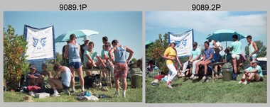 Bendigo Military Museum