Showing 825 items matching "gap road"
-
 Sunbury Family History and Heritage Society Inc.
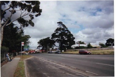
Photograph, Rosa McCall, Gap Road, Sunbury, 2000
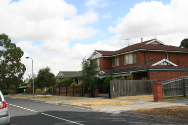
... Gap Road, Sunbury....Gap Road...The photograph is of Gap Road just west of Horne Street in Sunbury. ...The photograph is of Gap Road just west of Horne Street in Sunbury. ...The photograph is of Gap Road just west of Horne Street in Sunbury. The open ground on the RHS is on the corner of Pasley Street and was taken before the adjoining blue stone cottage was demolished. In 2020 the cottage was demolished and a large medical centre, complete with car parking was built on the property.Gap Road is one of Sunbury's main roads and is the quickest route to take from the town to the Calder Highway and on to Bendigo.A non-digital coloured photograph of a main road with a bus stop in the foreground and some open ground on the RHS of the image. gap road, pasley street, medical centre, sunbury -
 Beechworth Honey Archive
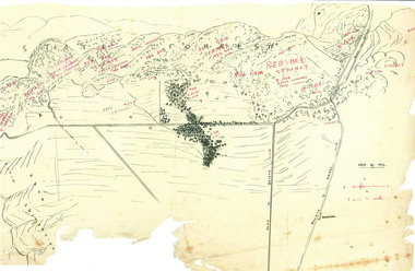
Hand-Drawn Map Centred on Buckland Gap Road by Frank Lebbell Frost July 1916
... Hand-Drawn Map Centred on Buckland Gap Road by Frank Lebbell Frost July 1916...Hand-drawn map centred on Buckland Gap road (near Murmungee). Details the quantity and quality of flowering timber in the nearby State Forest. ...Hand-Drawn Map Centred on Buckland Gap Road by Frank Lebbell Frost July 1916 ...This is one of the maps drawn by Frank L. Frost while he was beekeeping in North-East Victoria. This particular map may be reference in the "Wooden" Diary on page 8.Hand-drawn map centred on Buckland Gap road (near Murmungee). Details the quantity and quality of flowering timber in the nearby State Forest. Scale is 1/2 mile to 1 inch. Map was drawn on the 16th July, 1916. Drawn with black pen and grey lead on paper. Features are marked in red.hand drawn, hand-drawn, map, buckland gap, frost, beekeeper, beechworth honey -
 Sunbury Family History and Heritage Society Inc.
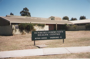
Photograph, Elwyn Davis, Former Sunbury Community Health Centre, March 2002
... ...Gap Road...The first Sunbury Community Health Centre was built on the corner of Horne Street and Gap Road in a temporary building. As result of further funding in 1974, a permanent building was erected and opened in 1981 and operated from that site until 2000 when it was relocated into a larger and more modern building on the former Sunbury Primary School site in Macedon Street to accommodate Sunbury's expanding population and needs.It now operates under the name of Sunbury and Cobaw Community Health Centre. ...Horne Street and Gap Road, Sunbury, Victoria, Australia...Sunbury Community Health Centre Health Centres Gap Road Horne Street A non-digital coloured photograph of the Sunbury Community Health Centre showing the notice board displayed in the front giving phone details and parking area. ...The first Sunbury Community Health Centre was built on the corner of Horne Street and Gap Road in a temporary building. As result of further funding in 1974, a permanent building was erected and opened in 1981 and operated from that site until 2000 when it was relocated into a larger and more modern building on the former Sunbury Primary School site in Macedon Street to accommodate Sunbury's expanding population and needs.It now operates under the name of Sunbury and Cobaw Community Health Centre. The old building was demolished and replaced with a fast-food outlet.A non-digital coloured photograph of the Sunbury Community Health Centre showing the notice board displayed in the front giving phone details and parking area.sunbury community health centre, health centres, gap road, horne street -
 Stawell Historical Society Inc
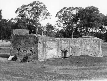
Photograph, Brick remains of the Tannery of Mr C Whel off Halls Gap Road Stawell West behind the London Hotel 1982
... Brick remains of the Tannery of Mr C Whel off Halls Gap Road Stawell West behind the London Hotel 1982...Brick remains of Tannery run by C Whel off Halls Gap Road Stawell West behind the London Hotel 1982...Stawell Historical Society Inc 46 Longfield St Stawell grampians Brick remains of Tannery run by C Whel off Halls Gap Road Stawell West behind the London Hotel 1982 Stawell Industry Brick remains of the Tannery of Mr C Whel off Halls Gap Road Stawell West behind the London Hotel 1982 Photograph ...Brick remains of Tannery run by C Whel off Halls Gap Road Stawell West behind the London Hotel 1982stawell industry -
 Stawell Historical Society Inc
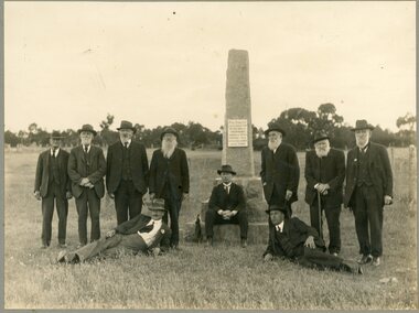
Photograph, "Peace" Memorial on Halls Gap Road built 1919 at site of old Treasury Building Commercial Street Pleasant Creek c1922
... "Peace" Memorial on Halls Gap Road built 1919 at site of old Treasury Building Commercial Street Pleasant Creek c1922...Group of Gentlemen beside the Peace Memorial situated on Halls Gap Road built 1919 at site of old Treasury Building Commercial Street Pleasant Creek. ...C1922 stawell "Peace" Memorial on Halls Gap Road built 1919 at site of old Treasury Building Commercial Street Pleasant Creek c1922 Photograph ...Group of Gentlemen beside the Peace Memorial situated on Halls Gap Road built 1919 at site of old Treasury Building Commercial Street Pleasant Creek. C1922stawell -
 Stawell Historical Society Inc
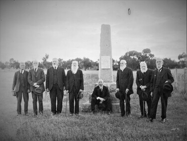
Photograph, "Peace" Memorial on Halls Gap Road built 1919 at site of old Treasury Building Commercial Street Pleasant Creek c1922
... "Peace" Memorial on Halls Gap Road built 1919 at site of old Treasury Building Commercial Street Pleasant Creek c1922...Group of Gentlemen beside the Peace Memorial situated on Halls Gap Road built 1919 at site of old Treasury Building Commercial Street Pleasant Creek. ...C1922 stawell "Peace" Memorial on Halls Gap Road built 1919 at site of old Treasury Building Commercial Street Pleasant Creek c1922 Photograph ...Group of Gentlemen beside the Peace Memorial situated on Halls Gap Road built 1919 at site of old Treasury Building Commercial Street Pleasant Creek. C1922stawell -
 Mt Dandenong & District Historical Society Inc.
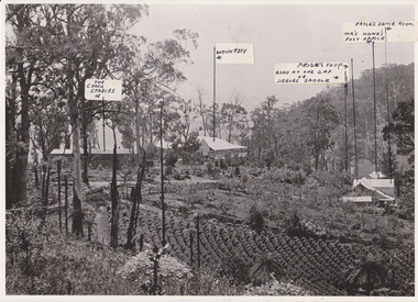
Photograph, 1908 View of the Kalorama Gap from Main Road With Labelling, 1908
... 1908 View of the Kalorama Gap from Main Road With Labelling....View of the Kalorama Gap from main Road (now Ridge Road), looking across Walker's raspberry patch with Mountjoy coaching stables on the LHS and Mountjoy Guest House in centre. ...1908 View of the Kalorama Gap from main Road – now Ridge Road above Lot 2 of the Village Settlement. ...This photograph has a detailed inscription on the back handwritten by John Lundy-Clarke in 1974. 1908 View of the Kalorama Gap from Main Road With Labelling. Photograph ...Photograph with labels attached to front identifying buildings. View of the Kalorama Gap from main Road (now Ridge Road), looking across Walker's raspberry patch with Mountjoy coaching stables on the LHS and Mountjoy Guest House in centre. Price's house and shop on the RHS. This photograph has a detailed inscription on the back handwritten by John Lundy-Clarke in 1974.1908 View of the Kalorama Gap from main Road – now Ridge Road above Lot 2 of the Village Settlement. Looking across Walker’s raspberry patch with “Mountjoy” coaching stables on left. “Mountjoy” in centre. Prices house and shop on right with Hands “Beulah Tearooms” above Prices roof. On hillside beyond Hand’s is the slope now taken up by Kalorama Terrace. Walker’s well, then newly dug is in lower right hand corner below the tree fern head. Mt Kalorama is the hill top right. Track leaving Main Road left is Walker’s entrance drive.kalorama, kalorama gap, walker, beulah tea rooms, price, hand, mountjoy, mt kalorama -
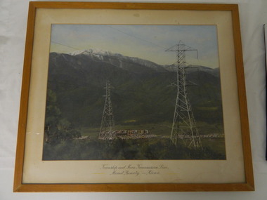 Kiewa Valley Historical Society
Framed photo - Mt Beauty Township & Main Transmission Line, 1954
... Mt Beauty; Transmission line; Tawonga Gap Road; Kiewa Hydro Electric Scheme...This is a photo of Mount Beauty taken from a high vantage point near the hair-pin bend on the Tawonga Gap Road (half way up) in 1954. Mount Beauty was built by the State Electricity Commission of Victoria during the construction of the Kiewa Hydro Electric Scheme....Mt Beauty; Transmission line; Tawonga Gap Road; Kiewa Hydro Electric Scheme Approx 1954 / Conroy-Moffatt Pty Ltd / Picture Framer / ..McKillop Street / Tel Mu .. 78 .... ...This is a photo of Mount Beauty taken from a high vantage point near the hair-pin bend on the Tawonga Gap Road (half way up) in 1954. Mount Beauty was built by the State Electricity Commission of Victoria during the construction of the Kiewa Hydro Electric Scheme.This photo belonged to Mr & Mrs Gordon White SECV employee and long time residents of Mt Beauty.This is a framed coloured photo of the Mount Beauty Township and main Transmission Line from Mt Beauty to Kiewa. The photo has two transmission lines in the foreground with the Mt Beauty township in the background, but at the foot of Mount Bogong.Approx 1954 / Conroy-Moffatt Pty Ltd / Picture Framer / ..McKillop Street / Tel Mu .. 78 ....mt beauty; transmission line; tawonga gap road; kiewa hydro electric scheme -
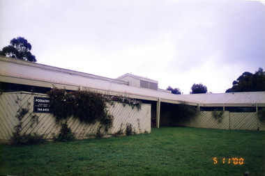 Sunbury Family History and Heritage Society Inc.
Photograph, Marilyn Bray, 5th November 2000
... ...Gap Road...In 1975, a new building opened on the corner of Gap Road and Horne Street. In 2000 as the health needs of the area increased the Community Health Centre relocated to a more modern building on the former Sunbury Primary School site in Macedon Street. ...In 1975, a new building opened on the corner of Gap Road and Horne Street. In 2000 as the health needs of the area increased the Community Health Centre relocated to a more modern building on the former Sunbury Primary School site in Macedon Street. ...The Shire of Bulla received a grant of $88,000 from the Federal Government on 14th March 1974. A public meeting was called to discuss how the funds would be used. After much discussion it was decided to establish a Community Health Centre for Sunbury and surrounding areas. In 1975, a new building opened on the corner of Gap Road and Horne Street. In 2000 as the health needs of the area increased the Community Health Centre relocated to a more modern building on the former Sunbury Primary School site in Macedon Street. The Horne Street building was sold to developers and a fast-food outlet now occupies the site.Over the years the Sunbury Community Health Centre has provided many important health related services for the community.A non-digital coloured photograph of an L shaped building with a low pitched roof and a trellis covering the front view of the building. A notice board attached to the trellis gives the details of a podiatry practice.sunbury community health centre, sunbury cobaw health centre, health centres, horne street, gap road, sunbury -
 Mt Dandenong & District Historical Society Inc.
Photograph, 1908 View of Kalorama Gap From the Main Road, 1908
... 1908 View of Kalorama Gap From the Main Road....View of the Kalorama Gap from main Road (now Ridge Road), looking across Walker's raspberry patch with Mountjoy coaching stables on the LHS and Mountjoy Guest House in centre. ...Farndons Community Hall 42 Falls Road Mt Dandenong yarra-valley-and-the-dandenong-ranges mountjoy walker raspberry coach stables View of the Kalorama Gap from main Road (now Ridge Road), looking across Walker's raspberry patch with Mountjoy coaching stables on the LHS and Mountjoy Guest House in centre. ...View of the Kalorama Gap from main Road (now Ridge Road), looking across Walker's raspberry patch with Mountjoy coaching stables on the LHS and Mountjoy Guest House in centre. Price's house and shop on the RHS.mountjoy, walker, raspberry, coach, stables -
 Stawell Historical Society Inc
Slide, Ian McCann, Constucting Lake Bellfield
... The Dam wall at lake Bellfield looking towards the halls Gap Road...Stawell Historical Society Inc 46 Longfield St Stawell grampians Lake Bellfield The Dam wall at lake Bellfield looking towards the halls Gap Road Constucting Lake Bellfield Slide Ian McCann ...The Dam wall at lake Bellfield looking towards the halls Gap Roadlake bellfield -
 Halls Gap & Grampians Historical Society
Photograph - B/W, C 1926
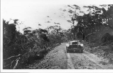
... Mirranatwa Gap was originally known as Yarram Gap; this name was given to the opposite gap on the Mt William side of the Dunkeld Road sometime in the mid 20th century. ...Photo shows car on Yarram Gap Road Road is rocky and unsealed. trees on left side of photo has been felled...An early touring car, claimed to be the first, crossing Mirranatwa (then Yarram) Gap. ACCESS ROUTES Roads Yarram Gap Photo shows car on Yarram Gap Road Road is rocky and unsealed. trees on left side of photo has been felled Photograph B/W ...Mirranatwa Gap was originally known as Yarram Gap; this name was given to the opposite gap on the Mt William side of the Dunkeld Road sometime in the mid 20th century. An early touring car, claimed to be the first, crossing Mirranatwa (then Yarram) Gap.Photo shows car on Yarram Gap Road Road is rocky and unsealed. trees on left side of photo has been felledaccess routes, roads, yarram gap -
 Stawell Historical Society Inc
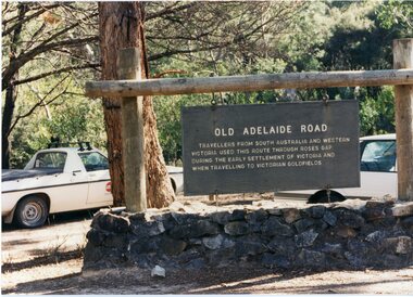
Photograph, Old Adelaide Road - Roses Gap, 29/04/1997
... Old Adelaide Road - Roses Gap...Old Adelaide Road - Roses Gap Photograph ...2 Colour Photographs; 1 Showing Old Adelaide road sign. 1 Large group of people outside.roses gap -
 Stawell Historical Society Inc
Photograph, Old Adelaide Road - Roses Gap, 29/04/1997
... Old Adelaide Road - Roses Gap...Old Adelaide Road - Roses Gap Photograph ...2 Colour Photographs; 1 Showing Old Adelaide road sign. 1 Large group of people outside.roses gap -
 Hume City Civic Collection
Photograph, early 1990s
... The series of 5 photographs feature different views of the Woodlands Housing Development which opened up land bounded by Gap and Anderson Roads, Cornish Street and Elizabeth Drive in the early 1990s. ...It is a photograph taken at the north end of Anderson Road looking towards Gap Road. One house has been built and there are a number of 'For Sale' signs of blocks fronting Anderson Road. ...It is a photograph taken at the north end of Anderson Road looking towards Gap Road. One house has been built and there are a number of 'For Sale' signs of blocks fronting Anderson Road. ...The series of 5 photographs feature different views of the Woodlands Housing Development which opened up land bounded by Gap and Anderson Roads, Cornish Street and Elizabeth Drive in the early 1990s. It was a large housing development built close to Sunbury township.A coloured photograph of one of the last housing developments which took place in the old township area. It is a photograph taken at the north end of Anderson Road looking towards Gap Road. One house has been built and there are a number of 'For Sale' signs of blocks fronting Anderson Road. Guttering and driveways have been formed on one side of the road.housing developments, anderson road, george evans collection -
 Stawell Historical Society Inc
Slide, Ian McCann, Lake Bellfield, 1960's
... Looking acroos Lake Bellfield to the Halls gap Dunkeld Road...Stawell Historical Society Inc 46 Longfield St Stawell grampians Grampians Lake Bellfield Looking acroos Lake Bellfield to the Halls gap Dunkeld Road Lake Bellfield Slide Ian McCann ...Looking acroos Lake Bellfield to the Halls gap Dunkeld Roadgrampians, lake bellfield -
 Halls Gap & Grampians Historical Society
Photograph - Sepia, C 1920
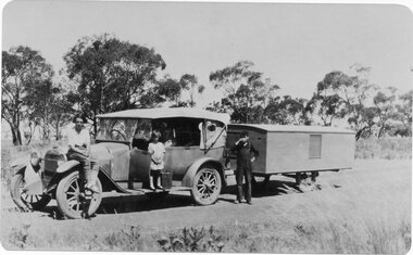
... Roses Gap Road at Wartook...Halls Gap & Grampians Historical Society Centennial Hall 117-119 Grampians Road Halls Gap grampians Roses Gap Road at Wartook RECREATION Camping ACCESS ROUTES Roads Roses Gap Rad at Wartook Photo shows car (T-Model Ford?) ...Roses Gap Road at WartookPhoto shows car (T-Model Ford?) with trailer Young woman sitting on front fender, small girl standing on running board, with gerry can beside her Other people in back seat of car Young boy standing near trailer drinking from a cupRoses Gap Rad at Wartookrecreation, camping, access routes, roads -
 Halls Gap & Grampians Historical Society
Photograph - B/W, C 1900
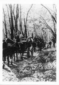
... A group of people on the Stawell-Halls Gap road on their way to an outing at the turn of the 19th century....Halls Gap & Grampians Historical Society Centennial Hall 117-119 Grampians Road Halls Gap grampians A group of people on the Stawell-Halls Gap road on their way to an outing at the turn of the 19th century. ...A group of people on the Stawell-Halls Gap road on their way to an outing at the turn of the 19th century.access routes, jinker track, transport, horse drawn -
 Halls Gap & Grampians Historical Society
Photograph - Coloured, 1998
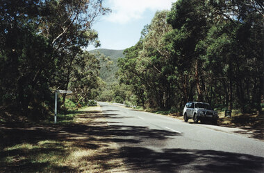
... Photo shows car parked at side of the road at Wannon Campground, looking north on the Halls Gap - Dunkeld Road....Halls Gap & Grampians Historical Society Centennial Hall 117-119 Grampians Road Halls Gap grampians ACCESS ROUTES Chalets Photo shows car parked at side of the road at Wannon Campground, looking north on the Halls Gap - Dunkeld Road. ...Photo shows car parked at side of the road at Wannon Campground, looking north on the Halls Gap - Dunkeld Road.access routes, chalets -
 Sunbury Family History and Heritage Society Inc.
Photograph, Rosa McCall, Anderson Road, Sunbury, February 2014
... The street in the photograph is Anderson Road, taken from the Darbyshire Street end and looking towards the SE to Gap Road. It was taken in February 2014. ...The street in the photograph is Anderson Road, taken from the Darbyshire Street end and looking towards the SE to Gap Road. It was taken in February 2014. Anderson Road Sunbury Darbyshire Road A non-digital coloured photograph of a street with a two storey house and three single storey homes. ...The street in the photograph is Anderson Road, taken from the Darbyshire Street end and looking towards the SE to Gap Road. It was taken in February 2014. A non-digital coloured photograph of a street with a two storey house and three single storey homes.anderson road, sunbury, darbyshire road -
 Hume City Civic Collection
Photograph, early 1980s
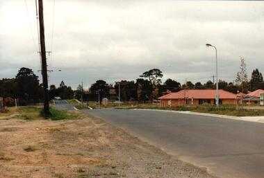
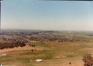
... The settlement at this stage extended along either side of Gap Road for about 0.5 km beyond Elizabeth Drive....The settlement at this stage extended along either side of Gap Road for about 0.5 km beyond Elizabeth Drive. sunbury township reservoir road mt. holden sunbury asylum george evans collection A coloured landscape photograph with rounded corners taken from Mt. ...The photograph shows the extent of Sunbury's development to the west of the town in the early 1980s. The settlement at this stage extended along either side of Gap Road for about 0.5 km beyond Elizabeth Drive.A coloured landscape photograph with rounded corners taken from Mt. Holden and looking towards the expanding town of Sunbury. The Melba Avenue drain which flows into Blind Creek is in the foreground. Sheoak Hill, the site of the former Sunbury Asylum is in the middle of the skyline.sunbury township, reservoir road, mt. holden, sunbury asylum, george evans collection -
 Halls Gap & Grampians Historical Society
Photograph - B/W
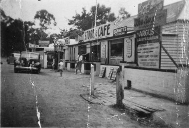
... See 'Bridging the Gap' p65. Grampians Road Halls Gap....Halls Gap & Grampians Historical Society Centennial Hall 117-119 Grampians Road Halls Gap grampians See 'Bridging the Gap' p65. ...See 'Bridging the Gap' p65. Grampians Road Halls Gap.Group of shops with numerous advertising signs. A woman is leaving a shop, a young girl is standing in front of her. Two cars are parked in front of shops. Gravel road. Large gum trees in the background.buildings, shops -
 Hume City Civic Collection
Photograph, 1980s
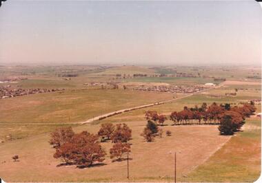
... It is looking south down Wilson's Lane towards some of the early Sunbury developments which grew around the Gap Road area in the early 1980s....It is looking south down Wilson's Lane towards some of the early Sunbury developments which grew around the Gap Road area in the early 1980s. wilson's lane mt. holden bald hill sunbury george evans collection A landscape coloured photograph with rounded corners. ...The photograph was taken above Reservoir Road on the lower slopes of Mt. Holden. It is looking south down Wilson's Lane towards some of the early Sunbury developments which grew around the Gap Road area in the early 1980s.A landscape coloured photograph with rounded corners. It is a panoramic view of Sunbury taken from the southern slopes of Mt. Holden. In the foreground there is a small cluster of trees and in the middle distance there is some evidence of housing development. Bald Hill can be seen on the skyline.wilson's lane, mt. holden, bald hill, sunbury, george evans collection -
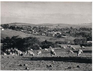 Hume City Civic Collection
Photograph, Early 1970s
... The Paynes housing development can be seen scattered across the hillside between Gap Road and Mitchells Lane....The Paynes housing development can be seen scattered across the hillside between Gap Road and Mitchells Lane. sunbury township goonawarra winery george evans collection A black and white photograph of a panoramic view of Sunbury township looking west and taken from above the Goonawarra Winery. ...The photograph was taken when Sunbury township did not extend far beyond Anderson Road to the west and Powlett Street to the east. The Paynes housing development can be seen scattered across the hillside between Gap Road and Mitchells Lane.A black and white photograph of a panoramic view of Sunbury township looking west and taken from above the Goonawarra Winery. Sheep are grazing on the hilside in the foreground.sunbury township, goonawarra winery, george evans collection -
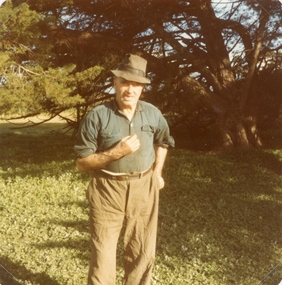 Stawell Historical Society Inc
Photograph, Mr Ernie Tremaine -- Coloured photograph c 1980"s
... Alice and her sister Dot Sharrock stopped to look at the Treasury memorial on the Halls Gap road. Mr. Tremaine lived nearby and came out to chat with them....Alice and her sister Dot Sharrock stopped to look at the Treasury memorial on the Halls Gap road. Mr. Tremaine lived nearby and came out to chat with them. stawell Coloured photo of Mr. ...The photo of Ernie Tremaine (died 16.4.1985) was taken by Alice Devereux. Alice and her sister Dot Sharrock stopped to look at the Treasury memorial on the Halls Gap road. Mr. Tremaine lived nearby and came out to chat with them.Coloured photo of Mr. Erne Tremaine dressed in casual clothes' and hat. c 1980'sstawell -
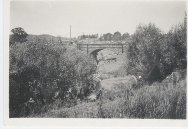 Sunbury Family History and Heritage Society Inc.
Photograph
... The single span bluestone bridge is on the Calder Highway at the base of Corkscrew Hill between Gap Road and the town of Gisborne. In the early 1990s the highway was widened and dual carriageways constructed, as a result the traffic no longer travelled along the winding Corkscrew Hill road. ...Sunbury Global Learning Centre Macedon Street Sunbury melbourne The single span bluestone bridge is on the Calder Highway at the base of Corkscrew Hill between Gap Road and the town of Gisborne. In the early 1990s the highway was widened and dual carriageways constructed, as a result the traffic no longer travelled along the winding Corkscrew Hill road. ...The single span bluestone bridge is on the Calder Highway at the base of Corkscrew Hill between Gap Road and the town of Gisborne. In the early 1990s the highway was widened and dual carriageways constructed, as a result the traffic no longer travelled along the winding Corkscrew Hill road. The bridge still stands between the two carriageways. A non-digital black and white photograph with a cream border of a single arched stone bridge spanning a watercourse. Small bushes are growing in the foreground and there are some buildings dotted across the hill in the middle distance.bridges, corkscrew hill, calder highway -
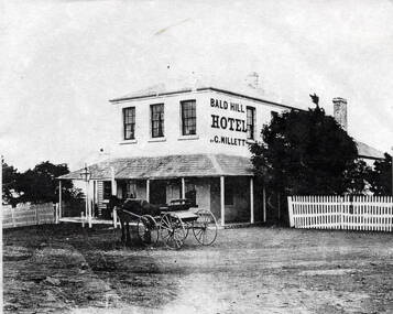 Sunbury Family History and Heritage Society Inc.
Photograph, Bald Hill Hotel
... The former Bald Hill Hotel was situated on the old Calder Highway at Diggers Rest between Mitchells Lane and present day Gap Road. It was one of many hotels built to provide a service for the passing gold fields traffic during the 1850s. ...The former Bald Hill Hotel was situated on the old Calder Highway at Diggers Rest between Mitchells Lane and present day Gap Road. It was one of many hotels built to provide a service for the passing gold fields traffic during the 1850s. ...The former Bald Hill Hotel was situated on the old Calder Highway at Diggers Rest between Mitchells Lane and present day Gap Road. It was one of many hotels built to provide a service for the passing gold fields traffic during the 1850s. During its existence, the Millett family owned the establishment.The site of the former hotel has significance for the 1850s gold rush period in Victoria and the development of Diggers Rest.A non-digital black and white photograph of a two storey hotel with a verandah across the front and a picket fence on either side of the building. A horse and buggy is parked outside the building. The words 'C.Millett, Bald Hill Hotel' are painted on the upper storey side wall of the building.millett family, hotels, the gap, bald hills hotel, diggers rest, gold rushes -
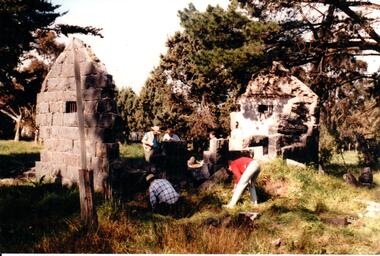 Hume City Civic Collection
Photograph, c 1993
... Aitkens Gap Police Lock up was originally constructed at The Gap which was south of the junction of Gap Road (Sunbury Road) and Calder Highway (Victoria St/Mt. ...Hume City Civic Collection 44 Macedon Street Sunbury melbourne Aitkens Gap Police Lock up was originally constructed at The Gap which was south of the junction of Gap Road (Sunbury Road) and Calder Highway (Victoria St/Mt. ...Aitkens Gap Police Lock up was originally constructed at The Gap which was south of the junction of Gap Road (Sunbury Road) and Calder Highway (Victoria St/Mt. Alexander Road). It was part of a police complex which was a changeover station for the gaol escort. The goal was relocated and rebuilt in the police station grounds in Sunbury in 1993.A coloured photograph of five men working on the removal of Aitkens Gap Gaol from its original site. Two end walls of the gaol are standing and the work is being done on the front and back of the building. Conifers and cypress trees are growing around the site.peter free, aitkens gap gaol, police historical association, sunbury police station, george evans collection -
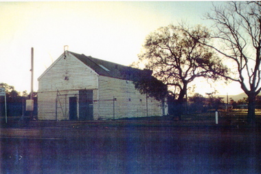 Sunbury Family History and Heritage Society Inc.
Photograph
... In latter years two depots were built out of the immediate shopping area in Jackson Street, opposite the Ball Court and at the intersection of Elizabeth Drive and Gap Road. ...In latter years two depots were built out of the immediate shopping area in Jackson Street, opposite the Ball Court and at the intersection of Elizabeth Drive and Gap Road. A fire service has operated in Sunbury at various sites for over 110 years. ...Sunbury Bush Fire Brigade was established in Evans Street in a small wooden building near the Post Office in 1910 and adjacent to the former recreation reserve. It was later moved to the opposite side of the street, near the former Collins Bookshop. In latter years two depots were built out of the immediate shopping area in Jackson Street, opposite the Ball Court and at the intersection of Elizabeth Drive and Gap Road. A fire service has operated in Sunbury at various sites for over 110 years.A coloured photograph of a weatherboard garage with a corrugated iron roof. A cyclone wire fence and gate are across the front and two trees are growing at the side of the building.sunbury bush fire brigade, evans street, sunbury, sunbury cfa