Showing 1138 items matching "geological"
-
 Stawell Historical Society Inc
Book, Norman Taylor, Geological Survey of Victoria No3, Geological Survey of Stawell, 1875-1876
... Geological Survey of Victoria No3, Geological Survey of Stawell...Geological Survey of Stawell 1875/76 by Norman Taylor, Geological Surveyor...Geological Survey of Victoria No.3 Geological Survey of Stawell Norman Taylor 1875/76...Stawell Historical Society Inc 46 Longfield St Stawell grampians Geological Survey of Stawell 1875/76 by Norman Taylor, Geological Surveyor stawell mining Geological Survey of Victoria No.3 Geological Survey of Stawell Norman Taylor 1875/76 Yellow Card Front and Rear Cover with B/W Picture of mining scene. with black Plastic spine Geological Survey of Victoria No3, Geological Survey of Stawell Book Norman Taylor ...Geological Survey of Stawell 1875/76 by Norman Taylor, Geological SurveyorYellow Card Front and Rear Cover with B/W Picture of mining scene. with black Plastic spineGeological Survey of Victoria No.3 Geological Survey of Stawell Norman Taylor 1875/76stawell mining -
 Stawell Historical Society Inc
Map, Geological Survey Office, Sloanes & Scotchmans united Mine, December 1916
... Sloane & Scotchman's Geological Survey Map 1916 Showing Underground Drives...Geological Survey Office Ballarat December 1916 ...Geological Survey Office...Stawell Historical Society Inc 46 Longfield St Stawell grampians mining gold map Geological Survey Office Ballarat December 1916 Sloane & Scotchman's Geological Survey Map 1916 Showing Underground Drives Sloanes & Scotchmans united Mine Map Geological Survey Office ...Sloane & Scotchman's Geological Survey Map 1916 Showing Underground DrivesGeological Survey Office Ballarat December 1916 mining, gold, map -
 Federation University Historical Collection
Map, Geological Survey of Victoria, 1913
... Geological Survey of Victoria...Geological Survey of Victoria...Barker Library (top floor) Mount Helen goldfields victoria geological survey of victoria gladstone talbot Printed colour map on paper Geological Survey of Victoria Map Map Geological Survey of Victoria ...Printed colour map on papervictoria, geological survey of victoria, gladstone, talbot -
Clunes Museum
Book, ROBERT S. BRAIN, BULLETINS OF THE GEOLOGICAL SURVEY OF VICTORIA, 1903
... BULLETINS OF THE GEOLOGICAL SURVEY OF VICTORIA...DEPARTMENT OF MINES, GEOLOGICAL SURVEY OF VICTORIA...BOOK - BULLETINS OF THE GEOLOGICAL SURVEY OF VICTORIA.. NO. 6 THE CLUNES GOLDFIELD BY W M. ...DEPARTMENT OF MINES, GEOLOGICAL SURVEY OF VICTORIA local history mining GEOLOGICAL SURVEY BULLETINS OF THE GEOLOGICAL SURVEY OF VICTORIA, AUSTRALIA. ...BULLETINS OF THE GEOLOGICAL SURVEY OF VICTORIA, AUSTRALIA.BOOK - BULLETINS OF THE GEOLOGICAL SURVEY OF VICTORIA.. NO. 6 THE CLUNES GOLDFIELD BY W M. BRADFORD.non-fictionBULLETINS OF THE GEOLOGICAL SURVEY OF VICTORIA, AUSTRALIA.local history, mining, geological survey -
 Stawell Historical Society Inc
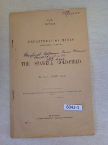
Book, E.J. Dunn, Department of Mines Geological Survey The Stawell Gold Field - Previously Cat No 3643-1, 1909
... Department of Mines Geological Survey The Stawell Gold Field - Previously Cat No 3643-1... A short Geological analysis of the Stawell Gold Fields...Dunn F.G.S Replicated from the Records of the Geological Survey of Victoria, Vol III. Part 1. ...Stawell Historical Society Inc 46 Longfield St Stawell grampians A short Geological analysis of the Stawell Gold Fields stawell mining 1909 Victoria Department of mines (Geological Survey) {in Ink} Brought at Melbourne Mines Museum, Russell St 7.3.78. ...A short Geological analysis of the Stawell Gold FieldsFawn Paper cover with two staples along spine1909 Victoria Department of mines (Geological Survey) {in Ink} Brought at Melbourne Mines Museum, Russell St 7.3.78. Ron Wood} The Stawell Gold Field By E.J. Dunn F.G.S Replicated from the Records of the Geological Survey of Victoria, Vol III. Part 1. By Authority J. Kemp, Government Printer, Melbourne. 7290 -2stawell mining -
 Federation University Historical Collection
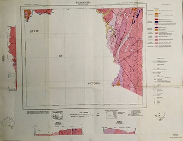
Map - Geological, Tallangatta, New South Wales: 1:250,000 Geological Series, SJ 55-3, 1966, 1966
... Tallangatta, New South Wales: 1:250,000 Geological Series, SJ 55-3, 1966...Compiled by the Geological Survey of N.S.W., Division of Regional Geology. ...Large coloured map showing geological features, faults, bores, rivers and mineral deposits....Barker Library (top floor) Mount Helen goldfields Compiled by the Geological Survey of N.S.W., Division of Regional Geology. ...Compiled by the Geological Survey of N.S.W., Division of Regional Geology. Topographical base compiled from Snowy Mountains Hydro Electrical Authority, Department of Lands, County maps and Snowy Lease Map. Other sheet adjoin this map. There are 13 formation sections grouped into 9 - Quaternary, Tertiary, Middle Devonian, Lower to Middle Devonian, Lower Devonian, Upper Silurian, Silurian, Upper Ordovician and Ordovician.Large coloured map showing geological features, faults, bores, rivers and mineral deposits.Scale of map, longitude and latitude, river names. "Tallangatta 1:250,00" written in black pen.tallangatta, new south wales, geological survey, topographical base, snowy mountains hydro electrical authority, department of lands, snowy lease map, department of mines, quaternary, tertiary, middle devonian, lower to middle devonian, lower devonian, uper siluran, silurian, upper ordovician, ordovician -
 Federation University Historical Collection
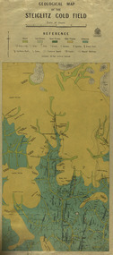
Map, Geological Map of The Stieglitz Gold Field, 1940
... Geological Map of The Stieglitz Gold Field......geology...At the bottom of the 2nd page, there is text that reads "Geologically and topographically surveyed in 1909 by W.H. ...Rectangular geological map edged in masking tape showing Steiglitz, Victoria. ...Published 1940." steiglitz geology geological map north albion moreep mining mine caribald reef durdidwarrah gilbraltar hill mount pleasant gully township of steiglitz W.H. ...At the bottom of the 2nd page, there is text that reads "Geologically and topographically surveyed in 1909 by W.H. Ferguson, Assistant Field Geologist. Published 1940."Rectangular geological map edged in masking tape showing Steiglitz, Victoria. Scale 48 chains to 4 inches.steiglitz, geology, geological map, north albion, moreep, mining, mine, caribald reef, durdidwarrah, gilbraltar hill, mount pleasant gully, township of steiglitz, w.h. ferguson, garibaldi reef, yankee gully, kinglock mine engine shaft, herbert werner frederick de nully, albion gully, virago reef, mulrooney's reef -
 Federation University Historical Collection
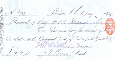
Document, Geological Society of London Subscription Receipt, 06/05/1889
... Geological Society of London Subscription Receipt...Krause lectured in Geology at the Ballarat School of Mines. His subscription to the Geological Society of London was paid by the School....Printed and handwritten receipt on blue paper from the Geological Society of London and made out to F.M. ...Krause lectured in Geology at the Ballarat School of Mines. His subscription to the Geological Society of London was paid by the School. ...Professor Ferdinand M. Krause lectured in Geology at the Ballarat School of Mines. His subscription to the Geological Society of London was paid by the School.Geology, geological, FM Krause, Ferdinand Krause, Ballarat School of Mines, FE Brown, Thomas WiltshirePrinted and handwritten receipt on blue paper from the Geological Society of London and made out to F.M. Krause of the Ballarat School of Mines. The receipt was signed by treasurer Thomas Wiltshire and clerk F.E. Brown. -
 Federation University Historical Collection
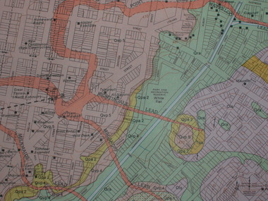
Plan, Ballarat Goldfield - Geological Survey of Victoria, 1981, 1981
... Ballarat Goldfield - Geological Survey of Victoria, 1981......geological...Coloured geological plan showing the Ballarat goldfields. ...Barker Library (top floor) Mount Helen goldfields ballarat geology geological gold nuggets mining mining companies gold leads Coloured geological plan showing the Ballarat goldfields. ...Coloured geological plan showing the Ballarat goldfields. It includes coloured scales and nuggets from the Ballarat Goldfield. It also shows leads and mines.ballarat, geology, geological, gold nuggets, mining, mining companies, gold leads -
 Federation University Historical Collection
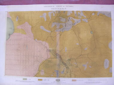
Map - Geological Survey, J. Phillips, Geological Survey of Victoria - Ballarat, 1857, 10/1858
... Geological Survey of Victoria - Ballarat, 1857......geological...Geological map of the Ballarat District featuring four colours....Geological Survey of Victoria - Ballarat, 1857 Map Geological Survey J. ...Geological map of the Ballarat District featuring four colours.ballarat, geological, geology, geological plan, main road, camp, golden point, pennyweight hill, clayton hill, ballaarat cemetery, bakery hill, specimen hill, soldiers hill, nightingale lead, native youth black hill flat, white flat, mining, mines, eureka lead, old post office hill -
 Federation University Historical Collection
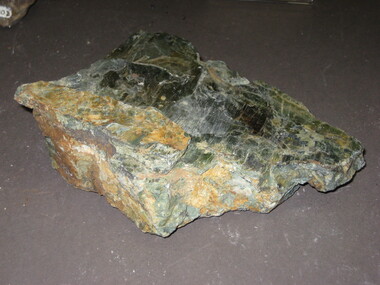
Rocks, Geological specimen
... Geological specimen......geology...Geological Specimen...Barker Library (top floor) Mount Helen goldfields From the Ballarat School of Mines. rocks geology Geological Specimen Geological specimen Rocks ...From the Ballarat School of Mines.Geological Specimenrocks, geology -
 Federation University Historical Collection
Geological specimen - Rock
... Geological Specimen......geology...Geological Specimen...Barker Library (top floor) Mount Helen goldfields From the Ballarat School of Mines. rocks geology jaspar jasper ballarat school of mines Geological Specimen Geological Specimen Geological specimen Rock ...From the Ballarat School of Mines.Geological Specimenrocks, geology, jaspar, jasper, ballarat school of mines -
Federation University Historical Collection
Rocks, Geological specimen
... Geological specimen......geology...Geological Specimen...From the Ballarat School of Mines. rocks geology Geological Specimen Geological specimen Rocks ...From the Ballarat School of Mines.Geological Specimenrocks, geology -
Stawell Historical Society Inc
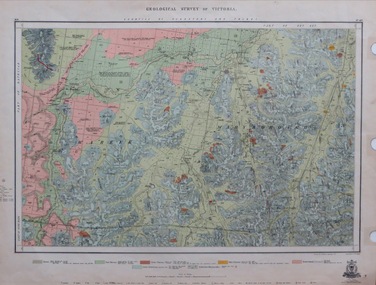
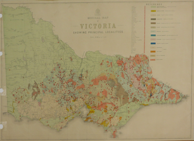
Map, Victorian Geological Map, 1963
... Victorian Geological Map...Victorian Geological Map...Stawell Historical Society Inc 46 Longfield St Stawell grampians Stawell Mining Victorian Geological Map Victorian Geological Map Map ...Victorian Geological Mapstawell, mining -
Stawell Historical Society Inc
Map, Geological Survey of Victoria
... Geological Survey of Victoria...Geological Survey of Victoria...Stawell Historical Society Inc 46 Longfield St Stawell grampians stawell Geological Survey of Victoria Geological Survey of Victoria Map ...Geological Survey of Victoriastawell -
 Federation University Historical Collection
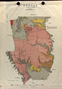
Map - Plan, E.J. Dunn, Bungal County of Grant Parish Plan
... Colour geological plan of Bungal in the County of Grant, Victoria. ......Geological Survey of Victoria...Bungal County of Grant Parish Plan Map Plan E.J. Dunn Geological Survey of Victoria State Regional Boundaries Committee Crown Lands and Survey ...E.J. Dunn was the surveyor of this parish plan.Colour geological plan of Bungal in the County of Grant, Victoria. The areas circled in red ar craters.plan, bungal, bungeltap, black horse co. egerton, egerton, mount egerton, sister rose shaft, south learmonth co, kerrit bareet, bungaeeltap, yaloak, eastern moorabool river, corong, bungal station preemptive right, lal lal, western moorabool river, moorabool rover, borhoneychurck, mount egerton battery, bungal creek -
 Federation University Historical Collection
Map, Department of Mines - Victoria, Geological Map of Victoria, 1936, 1936
... Geological Map of Victoria, 1936......geology...Printed colour geological map of Victoria....Barker Library (top floor) Mount Helen goldfields victoria geology map geological map Printed colour geological map of Victoria. ...Printed colour geological map of Victoria.victoria, geology, map, geological map -
 Federation University Historical Collection
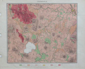
Map, Geological Map of Learmonth, 1882, 10/1882
... Geological Map of Learmonth, 1882...Two copies: (printed noted attached) 3.) Rectangular geological map edged in masking tape. Six colours define geology and are predominantly pink. ...Scale 40 chains to one inch .4) Notes referring to the Geological Map of Learmonth Geological Map of Learmonth, 1882 Map Map Norman Taylor Mining Department, Melbourne ...Two copies: (printed noted attached) 3.) Rectangular geological map edged in masking tape. Six colours define geology and are predominantly pink. Scale 40 chains to one inch .4) Notes referring to the Geological Map of Learmonth learmonth, lake learmonth, glendaruel, burrumbeet, mt blowhard, morton's hill, mt bolan, addington, mt cavern, coghill's hill, mt hollowback, mt pisgah, weatherboard hill, webster's hill, foster's hill, mt bolen, one mile hill, vaughan's hill, tourello stattion, ballarat to maryborough railway, saddleback hill, ceres, brown's hill, ross's hill, norman taylor, robert burrows, richard shephard, james finnie -
Federation University Historical Collection
Newsletter, Ballarat College of Advanced Education Students' Geological Society Newsletter, 1972, 1972
... Ballarat College of Advanced Education Students' Geological Society Newsletter, 1972...geology...Ballarat College of Advanced Education Students' Geological Society Newsletter and constitution....Barker Library (top floor) Mount Helen goldfields geology ballarat college of advanced education ballarat college of advanced education students' geological society geology Ballarat College of Advanced Education Students' Geological Society Newsletter and constitution. ...Ballarat College of Advanced Education Students' Geological Society Newsletter and constitution.geology, ballarat college of advanced education, ballarat college of advanced education students' geological society, geology -
 Federation University Historical Collection
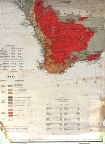
Map, Geological Map (Southern Western Australia), post 1880
... Geological Map (Southern Western Australia)...geology...A section of a map showing geology and routes of exploration. Southern Western Australia only ...Howitt, Burke & Wills, Hume & Hovell, Major Mitchell, A Forrest. geology exploration railways electric telegraphs A section of a map showing geology and routes of exploration. ...Includes the routes of exploration, including E. Giles, A. W. Howitt, Burke & Wills, Hume & Hovell, Major Mitchell, A Forrest.A section of a map showing geology and routes of exploration. Southern Western Australia only geology, exploration, railways, electric telegraphs -
University of Melbourne, Burnley Campus Archives
geological survey - Map, Geological Survey of Victoria - Australia 1:63 360 - A. Geelong B. Portarlington, 1963
... Geological Survey of Victoria - Australia 1:63 360 - A. ...B. Coloured geological survey map of Portarlington, Victoria. ...Geelong B. Portarlington geological survey Map ...A. Coloured geological survey map of Geelong area: showing sedimentary and igneous rock formations and contours. B. Coloured geological survey map of Portarlington, Victoria. By Dept. Of Mines, Melbourne. Scale 1 Mile to 1 inchgeelong, portarlington, victoria geological survey -
 Federation University Historical Collection
Plan, Ballarat Goldfields Geological Survey, 1981
... Ballarat Goldfields Geological Survey......geology...Large coloured plan showing streets, leads, geological zones and shafts. Source 1:10,000...Barker Library (top floor) Mount Helen goldfields ballarat gold goldfield geology sebastopol Large coloured plan showing streets, leads, geological zones and shafts. ...Large coloured plan showing streets, leads, geological zones and shafts. Source 1:10,000ballarat, gold, goldfield, geology, sebastopol -
 Ringwood and District Historical Society
Map - Maps, Geological Map Donvale to Chirnside Park, also Victorian Railways Maps of Hawthorn to Lilydale Line incl Ringwood to East Ringwood - 1881
... Geological Map Donvale to Chirnside Park, also Victorian Railways Maps of Hawthorn to Lilydale Line incl Ringwood to East Ringwood - 1881...Faint photocopies of sections of larger maps. Geological map includes location of mine shafts circa 1920....Faint photocopies of sections of larger maps. Geological map includes location of mine shafts circa 1920. ...Faint photocopies of sections of larger maps. Geological map includes location of mine shafts circa 1920.Victory Shaft, North Victory Shaft, South Caledonia Shaft, Caledonia Shaft, North Caledonia Shaft, Black Swan Shaft, Reward Shaft, Consols Shaft, Blocks Shaft, Devonshire Shaft, Crown Shaft, Yarra Tunnel Reef Working, Bright's Shaft, Kingwood Antimony Company Shaft (Boardman's Shaft), Southern Shaft. -
 Sunshine and District Historical Society Incorporated
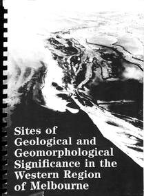
Book - Sites of Geological and Geomorphological Significance in the Western Region of Melbourne, Department of Conservation, Forest and Lands, Victoria, 1986
... Sites of Geological and Geomorphological Significance in the Western Region of Melbourne...Geological...Sites of Geological and Geomorphological Significance in the Western Region of Melbourne Book Sites of Geological and Geomorphological Significance in the Western Region of Melbourne Department of Conservation, Forest and Lands, Victoria N.J. ...Spiral bound publication, brief descriptions of sites with maps, photographs, indexes and references.geological, geomorphological -
 Federation University Historical Collection
Book, Memoirs of the Geological Survey of Victoria No 14 The Ballarat Goldfields, 1923, 1923
... Memoirs of the Geological Survey of Victoria No 14 The Ballarat Goldfields, 1923...geology...William Baragwanath was educated at the Ballarat School of Mines, obtaining a Geology Certificate in 1911. After further study he went on the become Secretary for Mines, and Chief Mining Surveyor. ...Contents include topography, physiography, historical, geology, basalt, faults, dykes, minerals leads, alluvial mines, nuggets, structure of Ballarat West goldfields, structure of Ballarat East gold-field, quartz formation, indicators, defunct mines, existing mines, table of deepest shafts. ...Baragwanath was a Councillor of the Ballarat School of Mine from 1916 to 1950. geology geological survey no 14 ballarat baragwanath William Baragwanath Pink covered foolscap book of 257 pages and 32 maps and plans by William Baragwanath. ...William Baragwanath was educated at the Ballarat School of Mines, obtaining a Geology Certificate in 1911. After further study he went on the become Secretary for Mines, and Chief Mining Surveyor. Baragwanath was a Councillor of the Ballarat School of Mine from 1916 to 1950.Pink covered foolscap book of 257 pages and 32 maps and plans by William Baragwanath. Contents include topography, physiography, historical, geology, basalt, faults, dykes, minerals leads, alluvial mines, nuggets, structure of Ballarat West goldfields, structure of Ballarat East gold-field, quartz formation, indicators, defunct mines, existing mines, table of deepest shafts. Images include: section of the Ballarat Gold-Field, Dead HOrse Flat, lakes formed by Basalt Flows, Gong Gong Creek, Frenchman's Lead, Ballarat West Mines, LEases and positions of shafts (1857), puddling, White Horse Lead, Woah Hawp Canton, Ballarat Township mines, Sebastopol, syncline, Victoria United Line, First Chance Mine, Llanberris No 1 Mine, Saddle Reef, New Normanby Mine, Woah Hawp Canton Mine, South Star Mine, Sebastopol Plateau, south Woah Hawp Mine, Woah No. 2 Minegeology, geological survey no 14, ballarat, baragwanath, william baragwanath -
Lakes Entrance Historical Society
Book, Douglas J G , Talent J A, Buchan Caves A Geological Discussion, 1977
... Buchan Caves A Geological Discussion...A short history of the geology of the Buchan Caves in East Gippsland Victoria, discovery after European settlement, and development as a tourist attraction....Buchan Caves A Geological Discussion Book Douglas J G , Talent J A ...A short history of the geology of the Buchan Caves in East Gippsland Victoria, discovery after European settlement, and development as a tourist attraction.genealogy, natural history, exploration, tourism -
 Federation University Historical Collection
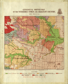
Map, Geological Sketch Map of the Werribee Gorge and Adjacent Country, 1914, 1914
... Geological Sketch Map of the Werribee Gorge and Adjacent Country, 1914...A coloured geological sketch map of the Werribee Gorge, Bacchus Marsh, Rowlesy, Darley, Parwan. ...The scale is 1 mile to 1 inch Geological Sketch Map of the Werribee Gorge and Adjacent Country, 1914 Map R. ...A coloured geological sketch map of the Werribee Gorge, Bacchus Marsh, Rowlesy, Darley, Parwan. The scale is 1 mile to 1 inchwerribee gorge, bacchus marsh, darley, parwan, w.e. bennett, bennett, r.a.f. murray, c.c. brittlebank, rowsley -
 Federation University Historical Collection
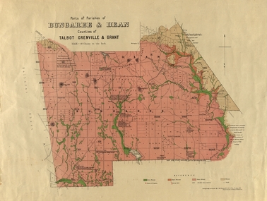
Plan, Bungaree and Dean Parish and Geological Plan, 1890, 07/1890
... Bungaree and Dean Parish and Geological Plan, 1890...Geological and Parish Map of parts of the Parishes of Bungaree and Dean in the Counties of Talbot, Grenville and Grant. ...Bungaree and Dean Parish and Geological Plan, 1890 Plan Plan Ferdinand M. Krause Department of Mines ...Ferdinand M. Krause was a Professor at the Ballarat School of Mines.Geological and Parish Map of parts of the Parishes of Bungaree and Dean in the Counties of Talbot, Grenville and Grant. The scale is 40 chains to one inch. bungaree, deen, krause, f.m. krause, musk creek, clarkes hill, badger hill, beale's reservoir, acquainted. -
Tatura Irrigation & Wartime Camps Museum
Document, Geological Plan, Eildon Dam Site, 1945
... Geological Plan, Eildon Dam Site...To record details of geological aspects of Eildon...Tatura Irrigation & Wartime Camps Museum 49 Hogan Street Tatura the-murray To record details of geological aspects of Eildon water/irrigation documents maps A series of maps illustrating rock formations etc., locations, boundaries and plans Geological Plan, Eildon Dam Site Document ...To record details of geological aspects of EildonA series of maps illustrating rock formations etc., locations, boundaries and planswater/irrigation, documents, maps -
 Federation University Historical Collection
Map, Ballaarat Gold Field, 1861, 1861
... A party of surveyors camped by Yuille's Swamp (later Lake Wendouree) and surveyed the countryside for a map to be produced by the Geological Survey of Victoria. In November 2004 the Central Highlands Regional Library presented a special edition of 200 copies of the 1861 map reproduced from a copy in their collection. ...Geological Survey of Victoria...Ballaarat Gold Field, 1861 Map Geological Survey of Victoria Robert Davidson Esq C.E. ...A party of surveyors camped by Yuille's Swamp (later Lake Wendouree) and surveyed the countryside for a map to be produced by the Geological Survey of Victoria. In November 2004 the Central Highlands Regional Library presented a special edition of 200 copies of the 1861 map reproduced from a copy in their collection. Original 1861 map of Ballarat showing streets and leads. Blue dots indicate gold leads, and red lines indicate auriferous quartz reef and outcrops of quartz veins."Compiled & Drawn from the Survey of Mining Surveyors Davidson, Fitzpatrick and Cowan & the Plans in the Surveyor General's Office by J. Brahe, 21st October 1861. R. Brough Smyth, Secretary for Mines. The Honourable J.B. Humffray, M.L.A. Commr of Mines.”ballarat, map, ballarat east, lake wendouree, survey, mines, robert davidson, ballarat gold field 1861, yuille's swamp, wendouree swamp, little bendigo diggings, gold leads, old post office hill, specimen hill, bakery hill, black hill, dead horse creek, brown hill, pennyweight hill, clayton hill, soldiers hill, golden point, gum tree flat, white flat, poverty hill, chinese village, robert brough smyth, ballarat map 1861, ballaarat vineyard, dead horse gully, deadhorse creek, invermay, black hill flat, gaelic church, police reserve, magpie range, dalton's flat, caadian lead, rifle butts, powder magazine, bathing house, government camp, gold office, chinese, llanberrris, victoria theatre, charlie napier hotel, united states hotel, grape's hoel, clayton's hill, cattleyard hill, free trade hotel, esmond lead, bakery hill, black hill lead, juvenile reformatory, ballarat orphanage, lady barkly lead, triffet's slaughter yard, little bendigo, melbourne road, t. cowan, thomas cowan