Showing 529 items matching "glen huntly rd houses"
-
 Glen Eira Historical Society
Historical Caulfield to 1972, photo album by Jenny O’Donnell, Glen Huntly Rd
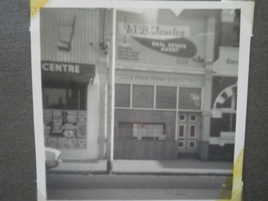
... ...Glen Huntly Rd Houses...Glen Eira Historical Society 965 Glen Huntly Rd Caulfield VIC 3162 melbourne Elsternwick Buildings Glen Huntly Rd Houses O’Donnell Jenny 1 photo of number 376 Historical Caulfield to 1972, photo album by Jenny O’Donnell, Glen Huntly Rd ...1 photo of number 376elsternwick, buildings, glen huntly rd houses, o’donnell, jenny -
 Glen Eira Historical Society
Historical Caulfield to 1972, photo album by Jenny O’Donnell, Glen Huntly Rd
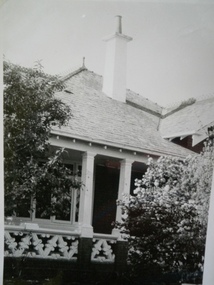
... Glen Huntly Rd...Victorian houses...Glen Eira Historical Society 965 Glen Huntly Rd Caulfield VIC 3162 melbourne Elsternwick Buildings Glen Huntly Rd Victorian houses Houses O’Donnell Jenny 1 photo of number 1027 Historical Caulfield to 1972, photo album by Jenny O’Donnell, Glen Huntly Rd ...1 photo of number 1027elsternwick, buildings, glen huntly rd, victorian houses, houses, o’donnell, jenny -
 Glen Eira Historical Society
Historical Caulfield to 1972, photo album by Jenny O’Donnell, Neerim Rd
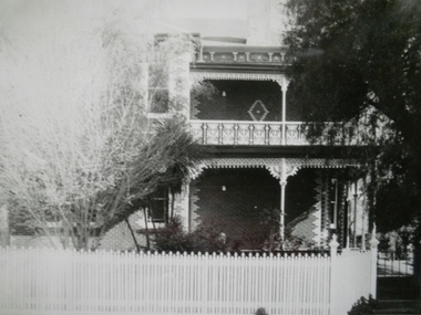
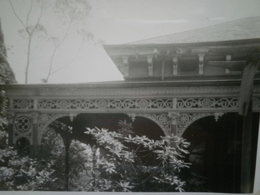
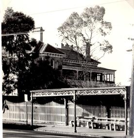
... Glen Huntly...Neerim Rd...Houses...Glen Eira Historical Society 965 Glen Huntly Rd Caulfield VIC 3162 melbourne Glen Huntly Neerim Rd Houses Victorian house O’Donnell Jenny 2 photos of number 37, a 2 storey Victorian with cast iron balustrade Historical Caulfield to 1972, photo album by Jenny O’Donnell, Neerim Rd ...2 photos of number 37, a 2 storey Victorian with cast iron balustradeglen huntly, neerim rd, houses, victorian house, o’donnell, jenny -
 Glen Eira Historical Society
Historical Caulfield to 1972, photo album by Jenny O’Donnell, Neerim Rd
... Glen Huntly...Neerim Rd...Houses...Glen Eira Historical Society 965 Glen Huntly Rd Caulfield VIC 3162 melbourne Glen Huntly Neerim Rd Houses Victorian house O’Donnell Jenny 1 photo of a Victorian house Historical Caulfield to 1972, photo album by Jenny O’Donnell, Neerim Rd ...1 photo of a Victorian houseglen huntly, neerim rd, houses, victorian house, o’donnell, jenny -
 Glen Eira Historical Society
Historical Caulfield to 1972, photo album by Jenny O’Donnell, Glen Huntly Rd
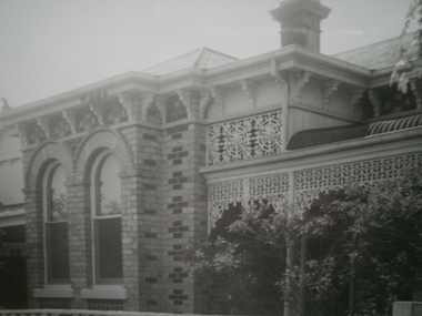
... Glen Huntly Rd...Glentana...Victorian houses...Glen Eira Historical Society 965 Glen Huntly Rd Caulfield VIC 3162 melbourne Elsternwick Buildings Glen Huntly Rd Glentana Victorian houses Houses O’Donnell Jenny 3 photos of number 805, Glentana Historical Caulfield to 1972, photo album by Jenny O’Donnell, Glen Huntly Rd ...3 photos of number 805, Glentanaelsternwick, buildings, glen huntly rd, glentana, victorian houses, houses, o’donnell, jenny -
 Glen Eira Historical Society
Document - PRAHRAN AND MALVERN TRAMWAYS TRUST
... Glen Eira Historical Society 965 Glen Huntly Rd Caulfield VIC 3162 melbourne This file has 3 items. 1/Photocopy of Caulfield Conservation Study Report by Andrew Ward dated January 1995 of 6-8 Rusden Street, Elsternwick being former Prahran and Malvern Tramways Trust substation. Report includes image, existing registrations, description of substation building and condition. 2/Original photograph (black and white) of tram shelter at corner of Balaclava Road and Orrong Road, Caulfield North, outside Grimwade House (school), description written on back of photo. 3/Original copy of magazine of the Tramway Museum Society of Victoria Ltd. ...This file has 3 items. 1/Photocopy of Caulfield Conservation Study Report by Andrew Ward dated January 1995 of 6-8 Rusden Street, Elsternwick being former Prahran and Malvern Tramways Trust substation. Report includes image, existing registrations, description of substation building and condition. 2/Original photograph (black and white) of tram shelter at corner of Balaclava Road and Orrong Road, Caulfield North, outside Grimwade House (school), description written on back of photo. 3/Original copy of magazine of the Tramway Museum Society of Victoria Ltd. ‘Running Journal’ Vol 7 No. 3 dated June 1970. Article (pages 3-7) entitled ‘Feeding & Filling, The Story of the Prahran & Malvern Tramways Trust’ written by Graeme Breydon. Article written for the 60th anniversary of the trust which opened for business on 30/05/1910 and describes the establishment and development of Tramways between suburbs of Malvern & Prahran including Elsternwick, Caulfield & Glen Huntly. Article includes 4 images plus map and diagram. Included: Photograph 3: Opening ceremony of tramway extension from Balaclava junction to Elsternwick railway station on Glen Huntly Road dated 13/11/1913. Diagram of various tramway routes including Prahran & Malvern Tramways Trust routes.prahran and malvern tramways trust, p+mtt, tram companies, land transport, public transport, substation, tram shelter, powerhouse, parapet, brick, stuccoed, roof lanterns, historic buildings register, national estate register, national trust register, rusden street, balaclava road, orrong road, hawthorn road, dandenong road, glen huntly road, grange road, elsternwick, elsternwick railway station, caulfield, caulfield north, caulfield railway station, point ormond, grimwade house, breydon graeme, tramcar, edwardian, transport, trams, tram depot -
 Glen Eira Historical Society
Document - Dairies
... Glen Eira Historical Society 965 Glen Huntly Rd Caulfield VIC 3162 melbourne This file contains two items: 1/A handwritten description of Margaret Bullock’s memories of the area where Sheridan’s dairy and house were in Kooyong Road, and of Lempriere’s Paddock. 2/A photocopied extract from Caulfield’s heritage vol. 1 by Dr. ...This file contains two items: 1/A handwritten description of Margaret Bullock’s memories of the area where Sheridan’s dairy and house were in Kooyong Road, and of Lempriere’s Paddock. 2/A photocopied extract from Caulfield’s heritage vol. 1 by Dr. Gewlah Solomon on Joseph Sheridan.sheridan, dairies, hospital, car park, sheridan’s paddocks, north road, bluestone, sheridan’s cottage, lempriere estate, white flett, berkley hospital, the little company of mary, bethlehem hospital, bullock margaret, stewart margaret, gardenvale road, kooyong road, sheridan joseph, dairyman, mansions, dairy farms, sheridan t. j., sheridan thomas, elsternwick, dairying -
Glen Eira Historical Society
Document - Hotels, Caulfield
... Glen Huntly Rd Caulfield VIC 3162 melbourne This file contains one item: 1/Handwritten research notes recording details about various hotels in the Caulfield area and environs. Details include handwritten maps and lists of publicans/licensees/nominees. Notes by author unknown and undated. Some of the notes make reference to entries in Sands & McDougall directories. R. K. Cole Hotel Collection London Tavern Hotel London Tavern and Store Glen Huntly Road Caulfield Sycamore Street Hawthorn Road Dandenong Road Derby Road Koornang Road Caulfield Club Hotel Rosstown Hotel Royal Hotel The Vine Beer House ...This file contains one item: 1/Handwritten research notes recording details about various hotels in the Caulfield area and environs. Details include handwritten maps and lists of publicans/licensees/nominees. Notes by author unknown and undated. Some of the notes make reference to entries in Sands & McDougall directories.r. k. cole hotel collection, london tavern hotel, london tavern and store, glen huntly road, caulfield, sycamore street, hawthorn road, dandenong road, derby road, koornang road, caulfield club hotel, rosstown hotel, royal hotel, the vine beer house, the vine caulfield hotel, newton h., balaclava road, bambra road, mirrambeena road, murrumbeena road, poath road, the tam o’shanter hotel, wilston street, farmers’ arms home hotel, chestnut street, hooper street, thompson william, martin p. j., orme frederick, orme fred, nicholls william henry, mullins john, armstrong john, egan james, westwood james, westwood ellen, greenberg david, greenberg sydney, greenberg rose, spamm cath, pitter mabel, morrow andrew, morrow andy, feddan george curtis, guess john, evans rowland, evans roland, riordan john, smith george elms, bedwell c., griffen frederick, connelly p. h., uhrbrock f., swift charles, gregor f., hazlett david, moore l., harley susan, mott h., nichols william henry, ross peter mclean, elsternwick, mcnamara margaret, mcnamara v., stevens catherine, mcgregor f., clarice george -
Glen Eira Historical Society
Letter - Lady Mackey
... Glen Eira Historical Society 965 Glen Huntly Rd Caulfield VIC 3162 melbourne This file contains 1 item: 1/A letter from Philipe Batters with a business card attached announcing Lady Mackey’s opening of a floral studio at her house, 24 Narong Road, Caulfield. ...This file contains 1 item: 1/A letter from Philipe Batters with a business card attached announcing Lady Mackey’s opening of a floral studio at her house, 24 Narong Road, Caulfield.mackey lady, caulfield, narong road, florists, lady mackey floral studio, batters philipe -
Glen Eira Historical Society
Ephemera - Orion Estate
... Glen Huntly Rd Caulfield VIC 3162 melbourne One item about this estate: 1/A black-and-white estate agents notice for the sale of Orion Estate at 3-o-clock on the Saturday 5th December 1880s. This notice details the sale of Orion Estate by public auction into allotments. Orion Estate Elsternwick Mars Street Jupiter Street Venus Street Saturn Street Kooyong Street Mercury Street Rosstown Junction Railway Real Estate Agents Railway Stations Lillie and Davis Auctions Ormond Station Hobsons Bay Elsternwick Station Glenhuntly Road Brighton Line Madden Walter Tunen August Building Surveyors Residential Development Plans Houses Ephemera Orion Estate ...One item about this estate: 1/A black-and-white estate agents notice for the sale of Orion Estate at 3-o-clock on the Saturday 5th December 1880s. This notice details the sale of Orion Estate by public auction into allotments.orion estate, elsternwick, mars street, jupiter street, venus street, saturn street, kooyong street, mercury street, rosstown junction railway, real estate agents, railway stations, lillie and davis, auctions, ormond station, hobsons bay, elsternwick station, glenhuntly road, brighton line, madden walter, tunen august, building surveyors, residential development, plans, houses -
Glen Eira Historical Society
Document - HRH Prince of Wales Visit to Caulfield 31/05/1920
... Glen Eira Historical Society 965 Glen Huntly Rd Caulfield VIC 3162 melbourne This file contains four items about the visit of HRH Prince of Wales Edward (later Edward VIII) to Australia in 1920 and specifically a visit to Caulfield on 31/05/1920. 1/A souvenir program ‘HRH Prince of Wales’ visit to Caulfield 31/05/1920: it appears to contain copies of the pages of a book, which it is noted was embossed by a patient at a Rest House in Caulfield, signaller Don Ende, a soldier of World War I. ...This file contains four items about the visit of HRH Prince of Wales Edward (later Edward VIII) to Australia in 1920 and specifically a visit to Caulfield on 31/05/1920. 1/A souvenir program ‘HRH Prince of Wales’ visit to Caulfield 31/05/1920: it appears to contain copies of the pages of a book, which it is noted was embossed by a patient at a Rest House in Caulfield, signaller Don Ende, a soldier of World War I. Included is a letter from the Caulfield Mayor W. A. Wharington and Town Clerk F. Jowett to Edward, as well as a typed reply from Edward to the mayor. Also included is a record of Caulfield’s contribution to the war effort during World War I, including numbers who enlisted and served, the number who died, and the amount of money raised from the Red Cross, Comforts Fund and other ‘Patriotic efforts’ by Caulfield residents. 2/Original letter by Edward to ‘Girls and Boys of Australia’, written in Sydney or 16/08/1920, thanking Australia for its contribution to the war effort and loyalty to the empire. 3/Three copies of the same letter by Edward to ‘Girls and Boys of Australia’. 4/A research note by Amy MacKintosh briefly describing the circumstance of Edward’s visit.royal visits, caulfields, wharington w. a., jowett f., edward prince of wales, edward viii, george v, red cross, comforts funds, caulfield military hospital, ende don, soldiers, rest house caulfield, world war 1914-1918, voluntary workers, charitable organisations, military hospitals -
Glen Eira Historical Society
Article - Balaclava Road, 91, Caulfield North, 'Miami'
... Glen Eira Historical Society 965 Glen Huntly Rd Caulfield VIC 3162 melbourne An undated page from the magazine Noel Jones and Associates Property Review featuring' Miami', Balaclava Road, 91, Caulfield North. On one side is a large colour photograph (230mm x 195mm) of the front of the house ...An undated page from the magazine Noel Jones and Associates Property Review featuring' Miami', Balaclava Road, 91, Caulfield North. On one side is a large colour photograph (230mm x 195mm) of the front of the house and on the reverse are three small colour photographs (all 60mm x 75mm) of different rooms. Includes a brief description of the house and details of the interior design. The house was to be auctioned on 25/09, year unknown.miami', balaclava road, caulfield north, mansions -
Glen Eira Historical Society
Document - Prentice Street, 57, Elsternwick
... Glen Eira Historical Society 965 Glen Huntly Rd Caulfield VIC 3162 melbourne This file contains two items: 1/Reprinted photographs of 57 Prentice Street, Elsternwick taken in 2013. 2/Research from Sands & McDougalls by Claire Barton from 1903-1942 editions, on residents in and at 57 Prentice Street. Elsternwick Prentice Street James Mrs. Martha James Creo W. Cottages Timber Houses ...This file contains two items: 1/Reprinted photographs of 57 Prentice Street, Elsternwick taken in 2013. 2/Research from Sands & McDougalls by Claire Barton from 1903-1942 editions, on residents in and at 57 Prentice Street.elsternwick, prentice street, james mrs. martha, james creo w., cottages, timber houses -
Glen Eira Historical Society
Article - Regent Street, 78, Elsternwick
... Glen Eira Historical Society 965 Glen Huntly Rd Caulfield VIC 3162 melbourne Three items about 78 Regent Street, Elsternwick. 1/Newspaper advertisement from the Bayside Weekly, 03/2009 for the sale of 78 Regent Street. Gives brief description of the house’s ...Three items about 78 Regent Street, Elsternwick. 1/Newspaper advertisement from the Bayside Weekly, 03/2009 for the sale of 78 Regent Street. Gives brief description of the house’s interior and exterior features. Includes one colour photograph of the house exterior and two colour photographs of the house interior. 2/Newspaper advertisement dated 08/09/2001, source unknown, advertising the sale of 78 Regent Street. Gives brief details of the house interior. Includes a colour photograph of the house exterior and a colour photograph of the Elsternwick Plaza area. 3/A research note by Claire Barton, dated 03/07/2012, referencing Sands and McDougall editions 1911, 1913, 1923, 1948, 1960 and 1970, giving names of previous occupants of 78 Regent Street.regent street, elsternwick, victorian style, williams kharla, stavrakis bill, buxton real estate, real estate agents, altman romana, cheeseman a n, elliott w m c, cope chas, evans hy t, evans e, cast iron work, verandahs -
Glen Eira Historical Society
Document - Noel Jones – Estate Agents
... Glen Huntly Rd Caulfield VIC 3162 melbourne This file contains one item: 1/A typewritten note from R. Landells, dated 26/02/1995, regarding the real estate agency, Noel Jones, in Glenhuntly Road, Elsternwick. Under the management of Mark Tappin, c.1987–1991, they continually asked for ‘house ...This file contains one item: 1/A typewritten note from R. Landells, dated 26/02/1995, regarding the real estate agency, Noel Jones, in Glenhuntly Road, Elsternwick. Under the management of Mark Tappin, c.1987–1991, they continually asked for ‘house histories’ to be completed.noel jones, real estate agencies, real estate agents, glenhuntly road, elsternwick, landells r., tappin mark, elsternwick post office -
Glen Eira Historical Society
Document - STANLEY STREET, 14, ELSTERNWICK
... Glen Eira Historical Society 965 Glen Huntly Rd Caulfield VIC 3162 melbourne This file contains two items about this property: 1/MELBOURNE WEEKLY advertisement dated 09/06/2010 giving brief details of house features and renovation details. ...This file contains two items about this property: 1/MELBOURNE WEEKLY advertisement dated 09/06/2010 giving brief details of house features and renovation details. Includes two coloured photographs. 2/Hand-written details on occupiers of 14 Stanley Street taken from Sands and McDougalls directories.stanley street, elsternwick, architectural features, plaster moulds, bay windows, emery marian mrs, emery percy e., mcdonald wm., riddell yolande s. carre, riddell consett carre, riddell m. e. carre miss, riddell stanley h., riddell stanley mrs., riddell walter j. carre, riddell thos w. carre, chairman board of works, cavers carre, ogg charles a., noisewood, carre street, orrong road, house names, biggin and scott -
Glen Eira Historical Society
Document - ST JAMES PARADE, 33, ELSTENRWICK, ‘AVALON’
... Glen Eira Historical Society 965 Glen Huntly Rd Caulfield VIC 3162 melbourne Contains 2 items about this property: 1/Two property advertisementss, dated 15/06/2002 on forth coming sale of property, including 4 photographs. 2/Handwritten research on occupiers of property by Claire Barton from Sands and McDougall on 15/03/2013. St James Parade Elsternwick ‘Avalon’ House ...Contains 2 items about this property: 1/Two property advertisementss, dated 15/06/2002 on forth coming sale of property, including 4 photographs. 2/Handwritten research on occupiers of property by Claire Barton from Sands and McDougall on 15/03/2013.st james parade, elsternwick, ‘avalon’, house names, spanish mission, architectural features, ‘o’neill estate’, fireplaces, lead lights, plaster moulds, geer clfrd. m, davis mrs annice f. -
Glen Eira Historical Society
Article - SHOOBRA ROAD, 82, ELSTERNWICK
... Glen Eira Historical Society 965 Glen Huntly Rd Caulfield VIC 3162 melbourne This file contains 2 items: 1/Newspaper article, includes two photographs of forthcoming sale of 82 Shoobra Road, Elsternwick on 17/08/2013. 2/Handwritten research by Claire Barton, on house owners taken from Sands and McDougalls from 1910 to 1960. ...This file contains 2 items: 1/Newspaper article, includes two photographs of forthcoming sale of 82 Shoobra Road, Elsternwick on 17/08/2013. 2/Handwritten research by Claire Barton, on house owners taken from Sands and McDougalls from 1910 to 1960.elsternwick, shoobra road, leadlights, verandah, timber houses, edwardian, plaster moulds, house auctions -
Glen Eira Historical Society
Document - AUSTRALIAN BI-CENTENARY 1788-1988
... Glen Eira Historical Society 965 Glen Huntly Rd Caulfield VIC 3162 melbourne This file contains a photocopy of an article in the Bi-centenary 88 Newsletter Vol7 No3, October 1987 referring to the mansion Labassa. The article states that the Labassa Mansion will receive funding under the A Gift to the Nation program – a Bi-Centenary project. Houses ...This file contains a photocopy of an article in the Bi-centenary 88 Newsletter Vol7 No3, October 1987 referring to the mansion Labassa. The article states that the Labassa Mansion will receive funding under the A Gift to the Nation program – a Bi-Centenary project.houses, mansions, labassa, historic buildings, historic events, festivals and celebrations, australian bi-centenary, business and finance, grants, a gift to the nation -
Glen Eira Historical Society
Document - Mimosa Road, 91, Carnegie
... Glen Eira Historical Society 965 Glen Huntly Rd Caulfield VIC 3162 melbourne This file contains 4 items: 1/7 pages of real estate advertisement, including colour and black-and-white exterior and interior photographs, downloaded from realestate.com.au, on 17/09/2007 prior to auction of the property on 06/10/2007. 2/A copy of a black-and-white photograph of exterior with Eric Darke, aged approximately 6 years, son of the first owners ca. 1927. 3/A copy of a colour photograph of exterior with later altered veranda, dated January 1982. 4/Research notes dated 30/05/2014, handwritten by Peta Darke, concerning the house and family at 91 Mimosa Road. ...This file contains 4 items: 1/7 pages of real estate advertisement, including colour and black-and-white exterior and interior photographs, downloaded from realestate.com.au, on 17/09/2007 prior to auction of the property on 06/10/2007. 2/A copy of a black-and-white photograph of exterior with Eric Darke, aged approximately 6 years, son of the first owners ca. 1927. 3/A copy of a colour photograph of exterior with later altered veranda, dated January 1982. 4/Research notes dated 30/05/2014, handwritten by Peta Darke, concerning the house and family at 91 Mimosa Road.carnegie, mimosa road, brick houses, koornang road, hocking stuart, staples mark, darke eric, darke frank mullis, darke edna joy, weeks edna, clothier peta, californian bungalows, wattle avenue, glen huntly, architectural styles, darke ruth marjorie, braden ruth marjorie, darke john cameron, darke frank macalister, darke richard alexander, darke alison joy -
Glen Eira Historical Society
Newsletter - CAULFIELD SOUTH COMMUNITY HOUSE
... Glen Eira Historical Society 965 Glen Huntly Rd Caulfield VIC 3162 melbourne Contains 3 items: 1/‘Caulfield South Community House – Minutes of Annual General Meeting, 18 October 2007’, (two pages) together with ‘Agenda of Annual General Meeting, 16 October 2008’ (one page). ...Contains 3 items: 1/‘Caulfield South Community House – Minutes of Annual General Meeting, 18 October 2007’, (two pages) together with ‘Agenda of Annual General Meeting, 16 October 2008’ (one page). The ‘Agenda’ notes that the Guest Speaker at the AGM will be Felicitie Campbell of the Glen Eira Historical Society. 2/‘Caulfield South Community House – Annual Report 2008’, a ten page booklet. Includes Financial Report for 2007-2008 and Manager’s Report. 3/‘Caulfield South Community House – Program Information, Semester 2, 2009’ Brochure (double sided) describing its programs, including Computer Classes, English as a Second Language and Health and Wellbeing classes.caulfield south, community house, caulfield south, community houses, community organisations, community groups, community services, gibson barbara, campbell felicitie, glen eira historical society, mironova marina, kooyong road, classes -
Glen Eira Historical Society
Letter - Whittaker, G, Mrs
... Glen Huntly Rd Caulfield VIC 3162 melbourne File contains 2 items: 1/ A handwritten letter by Mrs G. Whittaker on her personal memories/recollections of South Caulfield, which includes neighbours’ transport, homes, businesses and properties, some of which may have been included in ‘Sand, Swamp and Heath’ by Murray and Wells. 2/ Handwritten research note dated 27/09/2013 by Peta Darke concerning Mrs Whittaker’s parents’ house. ...File contains 2 items: 1/ A handwritten letter by Mrs G. Whittaker on her personal memories/recollections of South Caulfield, which includes neighbours’ transport, homes, businesses and properties, some of which may have been included in ‘Sand, Swamp and Heath’ by Murray and Wells. 2/ Handwritten research note dated 27/09/2013 by Peta Darke concerning Mrs Whittaker’s parents’ house.whittaker g mrs, caulfield, flowers street, council employees, caulfield council, chinese community, market gardens, quong sing, bealiba road, trams, bambra road, glenhuntly road, glen huntly road, pearce’s nursery, nurseries, pearce mr, prisoners, pearce street, chloris street, benbow family, griffiths brothers teas, griffiths street, longs bull paddock, long mr, methodist church, hawthorn road, camden town methodist, mcconchie harry, mcconchie cricket ii, glenhuntly road, camden court, freeman street, lomax frederick, chloris park -
Glen Eira Historical Society
Plan - LEMPRIERE AVENUE
... Glen Eira Historical Society 965 Glen Huntly Rd Caulfield VIC 3162 melbourne One item about this location 1/Excerpts (5 pages) from Andrew Wards Heritage Study vol 2, 3.6 on Lempriere Avenue and ‘Greenmeadows Gardens’ Historic Area include street plan and general view of Roselle Estate’, Greenmeadows Garden. Included in his description is mention of a large eucalypt in ‘Greenmeadows Gardens’ which pre-dates European settlement. Streetscape Lempriere Avenue ‘Greenmeadows Gardens’ Meadow Street Alston Grove Californian bungalow style Fences Spanish Mission style ‘Greenmeadows House ...One item about this location 1/Excerpts (5 pages) from Andrew Wards Heritage Study vol 2, 3.6 on Lempriere Avenue and ‘Greenmeadows Gardens’ Historic Area include street plan and general view of Roselle Estate’, Greenmeadows Garden. Included in his description is mention of a large eucalypt in ‘Greenmeadows Gardens’ which pre-dates European settlement.streetscape, lempriere avenue, ‘greenmeadows gardens’, meadow street, alston grove, californian bungalow style, fences, spanish mission style, ‘greenmeadows house, lempriere w. g., meadow street, clarke william senior, ‘greenmeadows’, trees, balaclava road, orrong road, allan road, meadow street, lempriere john, kirton mr, dickson and yorston (pty ltd), lempriere ruby l mrs, dickson g c, yorston j c, st kilda east, east st kilda, roselle estate, east st kilda, east st kilda riding -
Glen Eira Historical Society
Pamphlet - ARTHUR STREET, 15, CAULFIELD NORTH
... Glen Eira Historical Society 965 Glen Huntly Rd Caulfield VIC 3162 melbourne 2 items relating to 15 Arthur Street: 1/Newspaper article from Property Review Weekly, on forthcoming sale of property, includes photograph. 2/Gary Peer flyer, includes 4 photographs of home and house plan for forthcoming auction. ...2 items relating to 15 Arthur Street: 1/Newspaper article from Property Review Weekly, on forthcoming sale of property, includes photograph. 2/Gary Peer flyer, includes 4 photographs of home and house plan for forthcoming auction.caulfield north, arthur street, edwardian style, brick, lead lights, jeffries emma mrs., toohey jno w., white alick, hart m.g. mrs., green godwin a., mitton g. m., brown t. mrs., samuel lear, samuel aviv -
Glen Eira Historical Society
Document - BALACLAVA ROAD, 97,CAULFIELD, ‘NORMANHURST’
... Glen Huntly Rd Caulfield VIC 3162 melbourne Two items about this property: 1/Photocopied article on Mrs T.J. Confoy, Mary, who lived at ‘Normanhurst’, Balaclava Road. The article is from ‘Who’s Who in the World of Women’ circa 1930. Article mentions family and associations she is involved in. 2/Hand written research by Claire Barton from Sands and McDougall on the Confoy family in Balaclava Road. Caulfield Confoy Mary Confoy Edward Confoy John Confoy Leslie Strike Celie ‘Normanhust’ Strike Alex St Vincents de Paul’s Society St Vincent’s Hospital Racehorses Sports people Houses ...Two items about this property: 1/Photocopied article on Mrs T.J. Confoy, Mary, who lived at ‘Normanhurst’, Balaclava Road. The article is from ‘Who’s Who in the World of Women’ circa 1930. Article mentions family and associations she is involved in. 2/Hand written research by Claire Barton from Sands and McDougall on the Confoy family in Balaclava Road.caulfield, confoy mary, confoy edward, confoy john, confoy leslie, strike celie, ‘normanhust’, strike alex, st vincents de paul’s society, st vincent’s hospital, racehorses, sports people, houses, community services, committees of management, house names, voluntary workers, balaclava road -
Glen Eira Historical Society
Document - CLIFTON STREET, 5, CARNEGIE, ‘NESFIELD’
... Glen Huntly Rd Caulfield VIC 3162 melbourne This file contains two items: 1/Photocopied article from ‘Who’s Who in the World of Women’ circa 1930s of Doris Hedley. Gives family details and the charities and hobbies she was involved in. 2/Handwritten research by Claire Barton from Sands and McDougalls on the owners of 5 Clifton Street, Carnegie 1923-1948 Callander Claude A Voluntary Workers houses Caulfield East Hedley Doris Hedley Stanley Committees of Management Barton Claire Hedley Kenneth John Carnegie and Murrumbeena Auxiliary for the Blind Hedley Ronald Stanley Carnegie Caulfield Technical School Clifton Street House names Document CLIFTON STREET, 5, CARNEGIE, ‘NESFIELD’ ...This file contains two items: 1/Photocopied article from ‘Who’s Who in the World of Women’ circa 1930s of Doris Hedley. Gives family details and the charities and hobbies she was involved in. 2/Handwritten research by Claire Barton from Sands and McDougalls on the owners of 5 Clifton Street, Carnegie 1923-1948callander claude a, voluntary workers houses, caulfield east, hedley doris, hedley stanley, committees of management, barton claire, hedley kenneth john, carnegie and murrumbeena auxiliary for the blind, hedley ronald stanley, carnegie, caulfield technical school, clifton street, house names -
Glen Eira Historical Society
Document - BRIGGS STREET, 45, CAULFIELD, ‘STRETTON’
... Glen Eira Historical Society 965 Glen Huntly Rd Caulfield VIC 3162 melbourne 2 items about this property relating to Dorothy Margaret Aldom: 1/Printed article from ‘Who’s Who in The World of Women’ circa 1930’s on Dorothy Margaret Aldom, resident of Briggs Street, Caulfield. 2/Handwritten research document on Dorothy Margaret Aldom, taken from census records from 1904 to 1975, includes other members of her family. Notes made by Margaret Dunbar, GEHS researcher. Aldom Dorothy Margaret Aldom William Isaac Aldom Elizabeth Aldom Alice Martha Aldom Jera Treadway House ...2 items about this property relating to Dorothy Margaret Aldom: 1/Printed article from ‘Who’s Who in The World of Women’ circa 1930’s on Dorothy Margaret Aldom, resident of Briggs Street, Caulfield. 2/Handwritten research document on Dorothy Margaret Aldom, taken from census records from 1904 to 1975, includes other members of her family. Notes made by Margaret Dunbar, GEHS researcher.aldom dorothy margaret, aldom william isaac, aldom elizabeth, aldom alice martha, aldom jera treadway, house names, caulfield, briggs street, ‘stretton’, houses, domestic life, children’s services, voluntary workers, dunbar margaret, community services, pre-school education, childcare -
Glen Eira Historical Society
Article - BOORAN ROAD, 109, CAULFIELD SOUTH, ‘PONSONBY’
... Glen Eira Historical Society 965 Glen Huntly Rd Caulfield VIC 3162 melbourne This file contains four items: 1/Two page description of the house with colour exterior and interior photographs downloaded from realestate.com.au website in May 2014, after its sale in March 2013. 2/Two pages of handwritten notes dated 27/06/2014 by Peta Darke containing information about the former occupants of the house. 3/Handwritten list of directory entries for ‘Ponsonby’ from 1923 to 1970. ...This file contains four items: 1/Two page description of the house with colour exterior and interior photographs downloaded from realestate.com.au website in May 2014, after its sale in March 2013. 2/Two pages of handwritten notes dated 27/06/2014 by Peta Darke containing information about the former occupants of the house. 3/Handwritten list of directory entries for ‘Ponsonby’ from 1923 to 1970. Also, a page downloaded from Kendall Want Associates on 21/03/2014 describing Michelle Scheibner’s position there. 4/Nine brief articles copied from ‘The Argus’ over the years from 1916 to 1940 concerning various events and activities in the life of Flora Ponsonby Thompson.‘ponsonby’, booran road, caulfield south, ormond, north road, moore street, frederick street, brick houses, architectural styles, californian bungalows, ‘ormese’, munday audrey, munday j.r, narrawong road, thompson flora louise ponsonby, grocers, agg janette, thompson daphne ponsonby, thompson catherine ponsonby, garratt j, garratt catherine (kate), garratt ormee, garratt esme, st. agnes anglican church ormond, boxshall john, boxshall jack, boxshall ormee, scheibner carl h, scheibner esmee, scheibner michelle, mclaren andrew, whitby george, booksellers, shelford anglican girls school -
Glen Eira Historical Society
Document - Gardenvale, Elster Avenue, 7
... Glen Eira Historical Society 965 Glen Huntly Rd Caulfield VIC 3162 melbourne This file contains 3 items: 1/A copy of a colour photograph of the exterior of 7 Elster Avenue, taken in 1982 by Peta Darke. Includes Richard and Caroline Darke. 2/Resarch notes concerning 7 Elster Ave. dated 30/05/2014, handwritten by Peta Darke. Briefly describes history of the house ...This file contains 3 items: 1/A copy of a colour photograph of the exterior of 7 Elster Avenue, taken in 1982 by Peta Darke. Includes Richard and Caroline Darke. 2/Resarch notes concerning 7 Elster Ave. dated 30/05/2014, handwritten by Peta Darke. Briefly describes history of the house. 3/A list of directory entries dated 30/05/2014. By Peta Darke.elster avenue, gardenvale, magnolia road, gardenia road, mason walter, poole elliat, turvey clifford p., hrd e. j. miss, harding ian k., harding janet, harding susan, harding mark, harding murray, city of caulfield, gardenvale park, shels nell, darke richard, darke caroline, darke peta, parks and reserves, land use, brick houses -
Glen Eira Historical Society
Newspaper - MAYSBURY AVENUE, 5, ELSTERNWICK
... Glen Huntly Rd Caulfield VIC 3162 melbourne This file contains one item: 1/A sheet of A4 paper to which is attached a clipping from the Melbourne Weekly Bayside, dated 01/09/2010, advertising a property located at 5 Maysbury Avenue, Elsternwick. Listed are the property’s size, number of rooms, orientation and nearby amenities, as well as the viewing dates, auction date, and contact details for Biggin Scott real estate agents. Included are two colour photographs of the property’s living room and backyard. On the other side of the sheet of paper is a larger colour photograph of the property’s front yard. Houses ...This file contains one item: 1/A sheet of A4 paper to which is attached a clipping from the Melbourne Weekly Bayside, dated 01/09/2010, advertising a property located at 5 Maysbury Avenue, Elsternwick. Listed are the property’s size, number of rooms, orientation and nearby amenities, as well as the viewing dates, auction date, and contact details for Biggin Scott real estate agents. Included are two colour photographs of the property’s living room and backyard. On the other side of the sheet of paper is a larger colour photograph of the property’s front yard.houses, brick houses, maysbury avenue, elsternwick, lounges, fireplaces, clothes lines, front yards, biggin scott, real estate agents