
Showing 263 items matching "glen park road"
-
 Eltham District Historical Society Inc
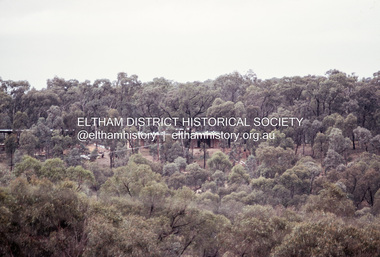
Photograph, Michael Wood, Houses on Progress Road viewed from Glen Park Road, Eltham North, February 1970, 1970
... Houses on Progress Road viewed from Glen Park Road, Eltham North, February 1970...alistair knox design, eltham north, hellemon, houses, progress road, Glen Park Road...Wood family home (1969-2011) pre and post construction by Knox and Hellemons Shows Wood family home on Progress Road in centre of field of view alistair knox design, eltham north, hellemon, houses, progress road, Glen Park Road Inscribed in ink "Hoses on Progress Rd from Glen Park Rd, Eltham North 1970" Kodachrome 35mm colour transparency in cardboard mount Processing date FEB70M6 Houses on Progress Road viewed from Glen Park Road, Eltham North, February 1970 Photograph Photograph Michael Wood ...Wood family home (1969-2011) pre and post construction by Knox and Hellemons Shows Wood family home on Progress Road in centre of field of viewKodachrome 35mm colour transparency in cardboard mount Processing date FEB70M6Inscribed in ink "Hoses on Progress Rd from Glen Park Rd, Eltham North 1970"alistair knox design, eltham north, hellemon, houses, progress road, glen park road -
 Eltham District Historical Society Inc
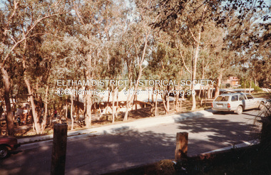
Photograph, Eltham North Primary School viewed from Glen Park Road, Eltham North, c.1983, 1983c
... Eltham North Primary School viewed from Glen Park Road, Eltham North, c.1983......glen park road...Originally contained in a 'magnetic' photo album believed to have been donated by Mr Eric Stephenson, Jingalong, 110 Ryans Road, Eltham, Vic. 3095; relocated to archival safe storage. eltham north eltham north primary school glen park road Colour photograph Eltham North Primary School viewed from Glen Park Road, Eltham North, c.1983 Photograph Photograph ...Originally contained in a 'magnetic' photo album believed to have been donated by Mr Eric Stephenson, Jingalong, 110 Ryans Road, Eltham, Vic. 3095; relocated to archival safe storage.Colour photographeltham north, eltham north primary school, glen park road -
 Nillumbik Shire Council
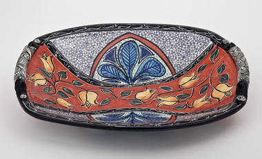
Ceramics (plate): Mary-Lou PITTARD, Mary-Lou Pittard, Serving platter
... 66 Glen Park Road , Eltham North, Outer Melbourne, Victoria, 3095, Australia ...Mary-Lou began exhibiting in the mid 1980s and over the years has been known for producing unique pieces of domestic ware influenced by food and traditional ceramic ware of the past.Food and tradition have always played a big part in Mary Lou’s ceramic work. 'Serving Platter' is rich in colour. The decorative designs are inspired by her surroundings in a style reminiscent of the past. Mary-Lou and husband Chris have a studio and gallery attached to their residential property in Eltham North which is open to the public. They also participate in the Nillumbik Artists Open Studios program. Oval platter with bold, stylised flowers glazed in reds, blues and yellows.mary-lou pittard, eltham, nillumbik, ceramic -
 Nillumbik Shire Council
Ceramics (vase): Chris PITTARD, Chris Pittard, Vessel - Flood, 2006
... 66 Glen Park Road, Eltham North, Outer Melbourne, Victoria, 3095, Australia ...Chris Pittard is a painter who has been working with clay for over 15 years. Pittard studied Fine Arts at RMIT and VCA and has exhibited paintings for a number of years. Pittard divides his time between teaching, drawing and painting and working in the ceramics studio where he creates distinctive pieces. Chris Pittard's ceramic pieces translate the narrative to the vessel. His vessels speak to us about our place and even his personal stories become more universal expressions.In early 2005 there was a flood which raged through the creeks cutting through the Shire of Nillumbik (Eltham). Not usually affected by catastrophe, these surging waters destroyed bridges and threatened roads. When the water subsided along the banks of the creek, trees had fallen, flotsam and jetsam piled up and even weeks later the long grass flattened by the flood continued to map the raging waters flow. The combination of slightly threatening and destructive forces and eerie beauty interested me. This at a time when world events of a far more horrific and tragic nature where presented to us by strangely beautiful coloured photos in our daily papers. These connections may not be obvious but it was certainly something I was thinking about while making this ceramic piece.flood, chris pittard, eltham, nillumbik -
 Eltham District Historical Society Inc
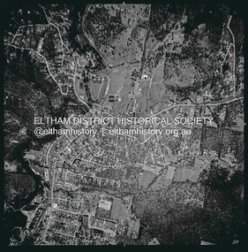
Photograph - Aerial Photograph, Landata, Eltham, Vic, Apr. 1963
... ...Glen Park Road...Centred on present day Zig Zag Road and Main Road, Eltham bounded by Maroondah Aqueduct to north, Thompson Crescent and Arthur Street to south, Parsons Road to east and Glen Park Road and Banks Road to west. Historic Aerial Imagery Source: Landata.vic.gov.au Aerial Photo Details: Project No :486 Project : MELBOURNE (1963) PROJECT Run : 5 Frame : 59 Date : 04/1963 Film Type : B/W Camera : RC8 Flying Height : 5100 Scale : 9600 Film Number : 1805 GDA2020 : 37°42'24"S, 145°08'52"E MGA2020 : 336716, 5825114 (55) Melways : 21 J3 (ed. 42)...Centred on present day Zig Zag Road and Main Road, Eltham bounded by Maroondah Aqueduct to north, Thompson Crescent and Arthur Street to south, Parsons Road to east and Glen Park Road and Banks Road to west. Historic Aerial Imagery Source: Landata.vic.gov.au Aerial Photo Details: Project No :486 Project : MELBOURNE (1963) PROJECT Run : 5 Frame : 59 Date : 04/1963 Film Type : B/W Camera : RC8 Flying Height : 5100 Scale : 9600 Film Number : 1805 GDA2020 : 37°42'24"S, 145°08'52"E MGA2020 : 336716, 5825114 (55) Melways : 21 J3 (ed. 42) Aerial Photo Neil Webster Collection Eltham 1963-04 Arthur Street Banks Road Glen Park Road Maroondah Aqueduct Melway 21J3 Parsons Road Digital jpg and electronic PDF file Eltham, Vic. ...Centred on present day Zig Zag Road and Main Road, Eltham bounded by Maroondah Aqueduct to north, Thompson Crescent and Arthur Street to south, Parsons Road to east and Glen Park Road and Banks Road to west. Historic Aerial Imagery Source: Landata.vic.gov.au Aerial Photo Details: Project No :486 Project : MELBOURNE (1963) PROJECT Run : 5 Frame : 59 Date : 04/1963 Film Type : B/W Camera : RC8 Flying Height : 5100 Scale : 9600 Film Number : 1805 GDA2020 : 37°42'24"S, 145°08'52"E MGA2020 : 336716, 5825114 (55) Melways : 21 J3 (ed. 42)aerial photo, neil webster collection, eltham, 1963-04, arthur street, banks road, glen park road, maroondah aqueduct, melway 21j3, parsons road -
 Eltham District Historical Society Inc
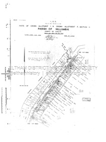
Document - Survey Plan, Country Roads Board, SP 6561, Eltham-Yarra Glen Road; Park Rd to Bellevue Rd, 1957
... SP 6561, Eltham-Yarra Glen Road; Park Rd to Bellevue Rd...Glen Road...Country Roads Board...Eltham...Main Road...Survey Plan...1957...A.R. Thomas...B. & B.D. Hearn...B.G. Anderson...Bellevue Road...E.M. Pitts...F.A. M. Macrae...G.E. & B. Moulder...J. Bromley...J.M. & S.G. Johnstone...K.F. Pitts...L.C. Docksey...M. & E.C.W. Baart...M.P. Bromley...N.R. Ord...P.J. & G.E. Murphy...Park...Toley Neil Webster Collection A3 print, 2 pages and electronic PDF file SP 6561, Eltham-Yarra Glen Road; Park Rd to Bellevue Rd Document Survey Plan Country Roads Board ...1957 C.R.B. Plan of Survey of Parts of Crown Allotment 1 & Crown Allotment F, Section II Parish of Nillumbik, County of Evelyn Eltham-Yarra Glen Road, Shire of Eltham Shows Surveyor field notes, property ownership and building type and construction.eltham-yarra glen road, country roads board, eltham, main road, survey plan, 1957, a.r. thomas, b. & b.d. hearn, b.g. anderson, bellevue road, e.m. pitts, f.a. m. macrae, g.e. & b. moulder, j. bromley, j.m. & s.g. johnstone, k.f. pitts, l.c. docksey, m. & e.c.w. baart, m.p. bromley, n.r. ord, p.j. & g.e. murphy, park road, r.a. bruce, r.a. macbeth, r.w. shearing, railway road, s.e. & y.p. houghton, w.k. bell, w.s.r. & f.n. toley, neil webster collection -
 Eltham District Historical Society Inc
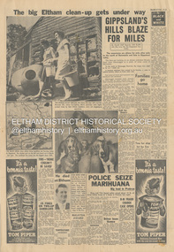
Newspaper - News Clipping, Herald, The big Eltham clean-up gets under way, Herald, 4 March, p3, 1965
... ...Glen Park Road...Flames caught the three men within yards of each other, not 200 yards off the Upper Glen Park Road where safety lay. They were burned to death. ...Flames caught the three men within yards of each other, not 200 yards off the Upper Glen Park Road where safety lay. They were burned to death. ...Full page newspaper clipping featuring the March 1965 Victorian bushfires. Items include: Photograph - TWO-WOMAN BUCKET BRIGADE, Mrs Henry Marsden (left) and Mrs Moureen Ellis, whose fire-fighting efforts yesterday were highly praised today by their Eltham neighbours, carry out mopping-up operations Photograph - DOGS MADE HOMELESS by the fire in North Eltham yesterday are being cared for at First-Constable Doug. Mummery's kennels at Eltham and here is kennel maid Helen Oliver, 17, with some of them today. The two basset hounds are owned by Mr Bill Guy who lost about 100 daschund and basset hound puppies and dogs in the fire. Photograph - He died at Eltham [Picture of John Lawrence Coleman] Builder Mr John Lawrence Coleman, 31, of Main Rd., Eltham, one of three men burnt to death yesterday in the fire at North Eltham. The other two were XXXXX, 33 who lives opposite the Colemans and Mr William Elwers, 64 of Batman Rd., Eltham. John Lawrence Coleman (1934-1965) born January 10, was the son of Raymond John Coleman and Hanna May (Gillet) Coleman. He married Margaret Frances Dare in 1955 and was the father of two children. He died whilst attempting to rescue an older man trapped in the bushfire at North Eltham on March 3, 1965 Other news stories of the day: Bushfires rage in Victoria, Snowy: Three dead (1965, March 4). The Canberra Times (ACT : 1926 - 1995), p. 1. Retrieved May 19, 2022, from http://nla.gov.au/nla.news-article131758981 Includes two photos of the fire in North Eltham “Firemen make for safety as fire rages in Upper Glen Park Road, North Eltham, Victoria. The smoke hides a house.” and “A house explodes into flames at North Eltham, Victoria. Firemen said bottled gas went up.” Canberra Times (ACT : 1926 - 1995), Thursday 4 March 1965, page 1 ________________________________________ Firemen make for safety as fire rages in Upper Glen Park Road. North Eltham. Victoria. The smoke hides a house. A house explodes into flames at North Eltham. Victoria. Firemen said bottled gas went up. Bushfires rage in Victoria, Snowy: Three dead MELBOURNE, Wednesday.—Three people died today in a bush» fire which raged through North Eltham, about 15 miles from Melbourne. The victims were three men. A fourth man is feared to be dead. Another bushfire. sparked off by the heatwave sizzling over south-eastern Australia, is burning out of control in the Kosciusko State Park, in the Snowy Mountains. Firefighters fear that if it reaches pine forests up the Yarrangobilly River, they will be powerless to stop it. The three victims of the North Eltbam fire were trapped by flames in a valley. Their bodies were found only a few yards apart. They were named by police tonight as Mr. George Crowe, 78, of North Eltham, William John Ewers, 64, and John Laurence Coleman, 31, both of Eltham. The other two have not been identified. They are believed to be a man aged about 40 and an 18-year-old youth. At least 12 homes were destroyed by the fire, the worst in Victoria since 1962, when eight lives were lost and hundreds of homes burnt down at Warrandyte. At one time the township of Eltham was threatened, but a cool change swept in from the south and held back the wall of flames. More than 100 dogs, worth about £4,000, died when the fire raced through two kennels in Short Street, Eltham. and Upper Glen Park Road, North Eltham. A trickle of water Residents ran into the streets as the blaze raced towards their houses. Others frantically dug firebreaks around their homes. Mrs. Sue Recourt wept when firemen arrived while she was vainly trying to stop the flames with a trickle of water from the garden hose. A stack of firewood was blazing, but the firemen managed to save the house and rescue four goats. Many homes in Eltham were saved after flames had crept to within feet of their fences. Students at North Eltham State School had to be evacuated when the blaze threatened the building. Fire fighters were severely hampered by lack of water and narrow roads. The blaze, which began in above century heat, turned toward Wattle Glen, where two houses were gutted. Then the flames raced towards Hurstbridge to the north. Firemen battling desperately, controlled the fire late this afternoon. Five forest fires were still burning in Victoria tonight. IN VICTORIA THIS WEEK Tragic lack of central fire authority (1965, March 9). The Canberra Times (ACT : 1926 - 1995), p. 2. Retrieved May 19, 2022, from http://nla.gov.au/nla.news-article131759928 Canberra Times (ACT : 1926 - 1995), Tuesday 9 March 1965, page 2 ________________________________________ IN VICTORIA THIS WEEK Tragic lack of central fire authority From Rohan Rivett It was the worst week for Victorian fire fighters since Black Friday 27 years ago. On that day one pilot up in a spotter plane said afterwards: "It seemed at times that half the State was on fire." This time, for three days on end, Gippsland men, women and children had moments of conviction that their towns would have blackened into anonymity before the weekend was out. The week began with horror at Eltham on the North-eastern edge of Melbourne. Eltham today is something of an artists' colony. Oil painters, water colourists, potters and sculptors proliferate. A number of University folk have emulated the example of Professor MacMahon Ball who pioneered the way by moving to Eltham and carving a home out of the bush in the thirties. Innermost Eltham is barely 14 miles from the G.P.O. Farthest Eltham stretches miles beyond. It served to illustrate the tragi-ludicrous truncation of Victoria's fire control. Part of Eltham is under the protection of the Melbourne Fire Brigade. But this responsibility ceases at some invisible and incomprehensible line — apparently determined by the meanderings of the water mains. At this point everybody's property throughout the rest of Eltham is dependent on the Country Fire Authority. Half an hour before midday on Wednesday, a fire suddenly started on the West side of Upper Glen road on the edge of Eltham. Before the fire brigade could arrive, it was burning on a widening front through timber and high grass north of Eltham. Two wind changes in rapid succession saw the fire leaping Diamond Creek. With a freshening wind it struck home after home in three streets. More than one of them exploded suddenly as if hit by an incendiary bomb. There is no piped gas in the Eltham area, hence many housewives use bottle gas. The flames outside caused the bottles to explode. Altogether twelve homes were completely incinerated and four more were badly damaged. Thirty prize dogs perished. About three hours after the fire started it raced suddenly down a gully hillside trapping an elderly man. Two other men apparently raced to the rescue. Flames caught the three men within yards of each other, not 200 yards off the Upper Glen Park Road where safety lay. They were burned to death. Next evening an angry and convincing secretary of the Fire Brigade Union, Mr. W. M. Webber, came on television and appealed to the people of Victoria to end the ridiculous and dangerous dualism in fire-fighting control. The Eltham fire, he said, had precisely illustrated the situation. The Metropolitan Fire Brigade area touched Eltham, but where the fire had gutted and killed, was just outside its area. Mr. Webber said his union had constantly urged one authority for the State with a complete reorganisation of fire protection. On Wednesday the union had repeated its call for an inquiry into fire protection in Victoria to the Chief Secretary, Mr Rylah. "No matter how close the liaison between the two organisations, there are always divided sections of thinking," Mr. Webber told viewers. "I don't know how much tragedy the com-munity can take before it demands that it is properly protected." Rumours that differences in gauge between taps and hose nozzles (as between the two authorities) accentuated the damage were denied by fire chiefs who said that all appliances were now carrying adaptors so that hoses could be linked to mains everywhere. But there is grave concern in the Metropolitan Fire Brigade's higher councils at the action of several Federal authorities with projects in and around Melbourne. They are installing non-standard equipment without reference to the State authorities or any dovetailing of appliances and equipment. Public alarm was not diminished by the publication on Friday and Saturday of a heart tearing letter from the young widow of John Lawrence Coleman, 31 year old father of two, who had died in the flames apparently trying to rescue the old man trapped in the gully. By that time, a Vast area of Gippsland was in flames and the troops had been sent in to back up the overworked and often helpless fire-fighters. By Saturday, the Leader of the Opposition, Mr. Stoneham, who has previously demanded a Royal Commission into fire-fighting arrangements, repeated his demand. To add to the Chief Secretary's worries he was publicly rebuked for allegedly implying on television that lives had been lost at Eltham because people went to the wrong place at the wrong time. In a letter to the Press, Professor MacMahon Ball pointed out that two of the men involved were experienced bushmen who had gone "to help an old man in great danger fully aware of the danger to themselves". As Victoria faced its sixth day of total State-wide fire ban, it looked likely that even official resistance was not going to silence the demand for one central authority to control the fire fiend. At the moment, the 400 square miles where two million Victorians live in Greater Melbourne are divorced from the rest of the State in planning, communications, equipment and control of personnel. No one doubts the whole-hearted co-operation and willingness to back each other up of the M.F.B. and the C.F.A., both at top-level and among the firemen themselves. However, when a city straggles so deeply into the country side, the absence of a single authority, to oversee and analyse the fire threat as a whole, suggests suicidal policy of divide and fuel. Emphasis of the tragic loss of a member of a pioneering family who died whilst helping others in his communitybushfire, cfa, country fire authority, fire brigrade, glen park road, heroes, john lawrence coleman, north eltham, victorian bushfires - 1965, volunteers, william john elwers, fire fighter, frank martin, george john crowe, ken gaston, orchard avenue, doug mummery, helen oliver, mrs henry marsden, mrs moureen ellis -
 Eltham District Historical Society Inc
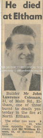
Newspaper - News Clipping, Herald, He died at Eltham. Herald, March 4, p3, 4 Mar 1965
... ...Glen Park Road...Flames caught the three men within yards of each other, not 200 yards off the Upper Glen Park Road where safety lay. They were burned to death. ...Flames caught the three men within yards of each other, not 200 yards off the Upper Glen Park Road where safety lay. They were burned to death. ...John Lawrence Coleman (1934-1965) born January 10, was the son of Raymond John Coleman and Hanna May (Gillet) Coleman. He married Margaret Frances Dare in 1955 and was the father of two children. He died whilst attempting to rescue an older man trapped in the bushfire at North Eltham on March 3, 1965 He died at Eltham (Herald, 4 March 1965, p3) [Picture of John Lawrence Coleman] Builder Mr John Lawrence Coleman, 31, of Main Rd., Eltham, one of three men burnt to death yesterday in the fire at North Eltham. The other two were XXXXX, 33 who lives opposite the Colemans and Mr William Elwers, 64 of Batman Rd., Eltham. * * * Frank Martin was a volunteer with the Eltham rural fire brigade at the time of the 1965 bushfires which burnt Eltham North and Research. Frank was asked to assist with the removal of three bodies from the back gully (now Orchard Avenue). They were badly burnt and one was found stuck under a fence as though trying to escape. Volunteers John Coleman Jnr, William Elwers and George Crowe were killed trying to protect Eltham from bushfire – they were local heroes. At the time, John Coleman Jnr was survived by his wife Margaret and two young children – John 11 and Vicky 2. Margaret Coleman lived in the family home until 1992 when she sold it and moved to Tasmania to be close to her son. She died in 1997 aged 65 years. 75 yr old Ken Gaston grew up on Edendale farm, which was originally a poultry farm but is now owned and run by the Shire of Nillumbik as an educational farm for schools and visitors. He was Captain of the Eltham rural fire brigade in 1965 when John Coleman Jnr was burnt to death in the Eltham North bushfires serving as an unofficial volunteer. He was able to draw where the original Wattletree Road was and at the time was verified with the location of some remaining bitumen and a post from the original bridge over the Diamond Creek located near the junction of the Diamond Creek and another small creek which is further down from Research or Christmas Creek as locals refer to it. The original Main Road ran behind Colemans before the railway line was built beyond Eltham in 1912. (Information recorded by Harry Gilham, President EDHS c.2011) * * * Bushfires rage in Victoria, Snowy: Three dead (1965, March 4). The Canberra Times (ACT : 1926 - 1995), p. 1. Retrieved May 19, 2022, from http://nla.gov.au/nla.news-article131758981 Includes two photos of the fire in North Eltham “Firemen make for safety as fire rages in Upper Glen Park Road, North Eltham, Victoria. The smoke hides a house.” and “A house explodes into flames at North Eltham, Victoria. Firemen said bottled gas went up.” Canberra Times (ACT : 1926 - 1995), Thursday 4 March 1965, page 1 ________________________________________ Firemen make for safety as fire rages in Upper Glen Park Road. North Eltham. Victoria. The smoke hides a house. A house explodes into flames at North Eltham. Victoria. Firemen said bottled gas went up. Bushfires rage in Victoria, Snowy: Three dead MELBOURNE, Wednesday.—Three people died today in a bush» fire which raged through North Eltham, about 15 miles from Melbourne. The victims were three men. A fourth man is feared to be dead. Another bushfire. sparked off by the heatwave sizzling over south-eastern Australia, is burning out of control in the Kosciusko State Park, in the Snowy Mountains. Firefighters fear that if it reaches pine forests up the Yarrangobilly River, they will be powerless to stop it. The three victims of the North Eltbam fire were trapped by flames in a valley. Their bodies were found only a few yards apart. They were named by police tonight as Mr. George Crowe, 78, of North Eltham, William John Ewers, 64, and John Laurence Coleman, 31, both of Eltham. The other two have not been identified. They are believed to be a man aged about 40 and an 18-year-old youth. At least 12 homes were destroyed by the fire, the worst in Victoria since 1962, when eight lives were lost and hundreds of homes burnt down at Warrandyte. At one time the township of Eltham was threatened, but a cool change swept in from the south and held back the wall of flames. More than 100 dogs, worth about £4,000, died when the fire raced through two kennels in Short Street, Eltham. and Upper Glen Park Road, North Eltham. A trickle of water Residents ran into the streets as the blaze raced towards their houses. Others frantically dug firebreaks around their homes. Mrs. Sue Recourt wept when firemen arrived while she was vainly trying to stop the flames with a trickle of water from the garden hose. A stack of firewood was blazing, but the firemen managed to save the house and rescue four goats. Many homes in Eltham were saved after flames had crept to within feet of their fences. Students at North Eltham State School had to be evacuated when the blaze threatened the building. Fire fighters were severely hampered by lack of water and narrow roads. The blaze, which began in above century heat, turned toward Wattle Glen, where two houses were gutted. Then the flames raced towards Hurstbridge to the north. Firemen battling desperately, controlled the fire late this afternoon. Five forest fires were still burning in Victoria tonight. IN VICTORIA THIS WEEK Tragic lack of central fire authority (1965, March 9). The Canberra Times (ACT : 1926 - 1995), p. 2. Retrieved May 19, 2022, from http://nla.gov.au/nla.news-article131759928 Canberra Times (ACT : 1926 - 1995), Tuesday 9 March 1965, page 2 ________________________________________ IN VICTORIA THIS WEEK Tragic lack of central fire authority From Rohan Rivett It was the worst week for Victorian fire fighters since Black Friday 27 years ago. On that day one pilot up in a spotter plane said afterwards: "It seemed at times that half the State was on fire." This time, for three days on end, Gippsland men, women and children had moments of conviction that their towns would have blackened into anonymity before the weekend was out. The week began with horror at Eltham on the North-eastern edge of Melbourne. Eltham today is something of an artists' colony. Oil painters, water colourists, potters and sculptors proliferate. A number of University folk have emulated the example of Professor MacMahon Ball who pioneered the way by moving to Eltham and carving a home out of the bush in the thirties. Innermost Eltham is barely 14 miles from the G.P.O. Farthest Eltham stretches miles beyond. It served to illustrate the tragi-ludicrous truncation of Victoria's fire control. Part of Eltham is under the protection of the Melbourne Fire Brigade. But this responsibility ceases at some invisible and incomprehensible line — apparently determined by the meanderings of the water mains. At this point everybody's property throughout the rest of Eltham is dependent on the Country Fire Authority. Half an hour before midday on Wednesday, a fire suddenly started on the West side of Upper Glen road on the edge of Eltham. Before the fire brigade could arrive, it was burning on a widening front through timber and high grass north of Eltham. Two wind changes in rapid succession saw the fire leaping Diamond Creek. With a freshening wind it struck home after home in three streets. More than one of them exploded suddenly as if hit by an incendiary bomb. There is no piped gas in the Eltham area, hence many housewives use bottle gas. The flames outside caused the bottles to explode. Altogether twelve homes were completely incinerated and four more were badly damaged. Thirty prize dogs perished. About three hours after the fire started it raced suddenly down a gully hillside trapping an elderly man. Two other men apparently raced to the rescue. Flames caught the three men within yards of each other, not 200 yards off the Upper Glen Park Road where safety lay. They were burned to death. Next evening an angry and convincing secretary of the Fire Brigade Union, Mr. W. M. Webber, came on television and appealed to the people of Victoria to end the ridiculous and dangerous dualism in fire-fighting control. The Eltham fire, he said, had precisely illustrated the situation. The Metropolitan Fire Brigade area touched Eltham, but where the fire had gutted and killed, was just outside its area. Mr. Webber said his union had constantly urged one authority for the State with a complete reorganisation of fire protection. On Wednesday the union had repeated its call for an inquiry into fire protection in Victoria to the Chief Secretary, Mr Rylah. "No matter how close the liaison between the two organisations, there are always divided sections of thinking," Mr. Webber told viewers. "I don't know how much tragedy the com-munity can take before it demands that it is properly protected." Rumours that differences in gauge between taps and hose nozzles (as between the two authorities) accentuated the damage were denied by fire chiefs who said that all appliances were now carrying adaptors so that hoses could be linked to mains everywhere. But there is grave concern in the Metropolitan Fire Brigade's higher councils at the action of several Federal authorities with projects in and around Melbourne. They are installing non-standard equipment without reference to the State authorities or any dovetailing of appliances and equipment. Public alarm was not diminished by the publication on Friday and Saturday of a heart tearing letter from the young widow of John Lawrence Coleman, 31 year old father of two, who had died in the flames apparently trying to rescue the old man trapped in the gully. By that time, a Vast area of Gippsland was in flames and the troops had been sent in to back up the overworked and often helpless fire-fighters. By Saturday, the Leader of the Opposition, Mr. Stoneham, who has previously demanded a Royal Commission into fire-fighting arrangements, repeated his demand. To add to the Chief Secretary's worries he was publicly rebuked for allegedly implying on television that lives had been lost at Eltham because people went to the wrong place at the wrong time. In a letter to the Press, Professor MacMahon Ball pointed out that two of the men involved were experienced bushmen who had gone "to help an old man in great danger fully aware of the danger to themselves". As Victoria faced its sixth day of total State-wide fire ban, it looked likely that even official resistance was not going to silence the demand for one central authority to control the fire fiend. At the moment, the 400 square miles where two million Victorians live in Greater Melbourne are divorced from the rest of the State in planning, communications, equipment and control of personnel. No one doubts the whole-hearted co-operation and willingness to back each other up of the M.F.B. and the C.F.A., both at top-level and among the firemen themselves. However, when a city straggles so deeply into the country side, the absence of a single authority, to oversee and analyse the fire threat as a whole, suggests suicidal policy of divide and fuel. Emphasis of the tragic loss of a member of a pioneering family who died whilst helping others in his communitybushfire, cfa, country fire authority, fire brigrade, glen park road, heroes, john lawrence coleman, north eltham, victorian bushfires - 1965, volunteers, william john elwers, fire fighter, frank martin, george john crowe, ken gaston, orchard avenue -
 Eltham District Historical Society Inc
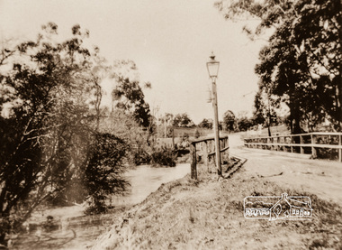
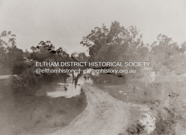
Photograph, Diamond Creek Bridge, Eltham North, c.1920
... ...Glen Park Road...Glen Park Road intersected Main Rain Road along an alignment following present day Coleman Cresent. ...Glen Park Road intersected Main Rain Road along an alignment following present day Coleman Cresent. ...View looking east across the Glen Park Bridge and the railway crossing towards Main Road circa 1920. The bridge was originally built as a replacement for an older private bridge built by a man named Foley around 1880. In 1911 Heidelberg and Eltham agreed to share the costs to build a new bridge (the Diamond Creek was the border between the two). Construction began in June 1915 and it was officially opened by Cr. Taylor on Cup Day, November 1915. This photo, dated around 1920, is of the Glen Park Bridge crossing over the Diamond Creek about 50 metres north of the present-day Wattletree tree Road Bridge. Glen Park Road intersected Main Rain Road along an alignment following present day Coleman Cresent. In this this picture we see the narrow wooden bridge over a high flowing Diamond Creek at Glen Park, now Eltham North. In the background is a railway crossing sign. There is a self-contained carbide streetlamp situated in front of the bridge. In the early 1900s, carbide (acetylene gas) streetlamps emerged as a lighting technology for regional towns across Victoria, Australia, before municipal electricity grids were widely established. During the late Victorian and early Edwardian eras, major hubs like Melbourne relied on centralized coal-gas infrastructure. However, small regional Victorian shires lacked the funds or population density to build large gasworks. When the commercial production of calcium carbide became viable around 1900, it offered a quantum leap in brightness over traditional kerosene streetlamps. Acetylene gas burned with an intense, crisp white flame—significantly brighter than oil or candles. Many rural towns used self-contained lampposts. A lamplighter had to climb each post daily to manually place calcium carbide pellets in a lower chamber and fill an upper chamber with water. The water dripped onto the carbide, producing acetylene gas to feed the burner. Lamplighters carefully measured the fuel amounts so the chemical reaction would naturally exhaust itself and "turn off" around midnight. While carbide streetlights provided unparalleled visibility for early motorists, cyclists, and pedestrians, they were incredibly labour-intensive and inherently volatile. The gas was highly explosive, prone to leaks, and left behind a pungent, sulphur-like odour. By the end of World War I, local Victorian councils rapidly phased out acetylene infrastructure in favour of safer, independent electric powerhouse generators. In the context of Eltham's local history, the Eltham Shire and surrounding Yarra Valley region actively relied on carbide streetlamps and kerosene lighting during the early 20th century before the expansion of the Melbourne electric grid. Eltham was an outer-rural, heavily timbered farming and orchard district at the turn of the century, it faced unique civic infrastructure challenges. In rural Eltham, early streetlamps were exceptionally sparse. The community relied heavily on "innkeeper laws" which dictated local hotels—such as the historic Eltham Hotel—were legally required to keep external oil, kerosene, or acetylene lamps burning through the night to illuminate the main roads for travellers and coaches. The volatile carbide and kerosene lamps on Eltham's main thoroughfares were progressively phased out during the 1920s. The district steadily transitioned to electricity, which allowed for developments like the installation of modern electrical wiring at the local fire station on Arthur Street by 1928. The Glen Park Bridge was a low structure and subject to flooding readily. In 1959 Eltham Council erected a new crossing over the Diamond Creek and realigned the road to the present-day Wattletree Road Bridge. Construction was not fully complete when on Sunday, 20 September 1959, heavy flooding occurred in the stream and at 3:53 pm the old bridge was washed away forever. - Research by Peter Pidgeon, EDHS, June 2026Photograph copy eltham north, wattletree road, coleman crescent, bridges, diamond creek (creek), bridge, carbide streetlamp, floodwater, glen park bridge, street lamp, glen park road, glen park estate -
 Eltham District Historical Society Inc
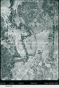
Photograph - Aerial Photograph, Landata, Eltham, Main Rd; Railway Rd to Zig Zag Rd, Dec. 1945
... glen road...Eltham-Hurstbridge Railway line...Gastons Homestead...Gastons Road...Glen Park...Centred on present day Edendale Farm from Glen Park rd to Zig Zag Rd Historic Aerial Imagery Source: Landata.vic.gov.au Aerial Photo Details: Project No :5 Project : MELBOURNE AND METROPOLITAN AREA PROJECT Run : 37 Frame : 60549 Date : 12/1945 Film Type : B/W Camera : EAG4 Flying Height : 10200 Scale : 6000 Film Number : 196 GDA2020 : 37°42'12"S, 145°09'09"E MGA2020 : 337141, 5825486 (55) Melways : 21 K2 (ed. 42) Aerial Photo Eltham Edendale Farm eltham - yarra glen road Eltham-Hurstbridge Railway line Gastons Homestead Gastons Road Glen Park Road Main Road Park Road railway road Wattletree Road Zig Zag Road Neil Webster Collection A3 photo print and electronic PDF file Eltham, Main Rd; Railway Rd to Zig Zag Rd Photograph Aerial Photograph Landata ...Centred on present day Edendale Farm from Glen Park rd to Zig Zag Rd Historic Aerial Imagery Source: Landata.vic.gov.au Aerial Photo Details: Project No :5 Project : MELBOURNE AND METROPOLITAN AREA PROJECT Run : 37 Frame : 60549 Date : 12/1945 Film Type : B/W Camera : EAG4 Flying Height : 10200 Scale : 6000 Film Number : 196 GDA2020 : 37°42'12"S, 145°09'09"E MGA2020 : 337141, 5825486 (55) Melways : 21 K2 (ed. 42)aerial photo, eltham, edendale farm, eltham - yarra glen road, eltham-hurstbridge railway line, gastons homestead, gastons road, glen park road, main road, park road, railway road, wattletree road, zig zag road, neil webster collection -
 Eltham District Historical Society Inc
Photograph, Diamond Creek in flood over Glen Park Bridge, Eltham, c. 26 August 1924
... ...Glen Park Road...Significant flooding of the Diamond Creek occurred in Eltham and Glen Park on Tuesday, August 26, 1924 with several houses swamped and all bridges covered except the Greensborough Road Bridge. ...The new bridge west embankment joined the existing road at approximately where the bend in the road is situated in the photograph. floods eltham Diamond Creek (Creek) Egan's Crossing Eltham-Diamond Creek Road Glen Park Bridge Glen Park Road Colour photograph of original Diamond Creek in flood over Glen Park Bridge, Eltham Photograph Photograph ...Significant flooding of the Diamond Creek occurred in Eltham and Glen Park on Tuesday, August 26, 1924 with several houses swamped and all bridges covered except the Greensborough Road Bridge. [Houses at Eltham Flooded. (1924, August 27). The Argus (Melbourne, Vic. : 1848 - 1957), p. 19. Retrieved from http://nla.gov.au/nla.news-article4156891] The Glen Park Bridge was originally built as a replacement for an older private bridge built by a man named Foley around 1880. In 1911 Heidelberg and Eltham agreed to share the costs to build a new bridge. Construction began in June 1915 and it was officially opened by Cr. Taylor on Cup Day, November 1915. The bridge was destroyed by floodwaters in the afternoon of 20 September 1959 during construction of the new Wattletree Road bridge. The new bridge west embankment joined the existing road at approximately where the bend in the road is situated in the photograph.Colour photograph of originalfloods, eltham, diamond creek (creek), egan's crossing, eltham-diamond creek road, glen park bridge, glen park road -
 Eltham District Historical Society Inc
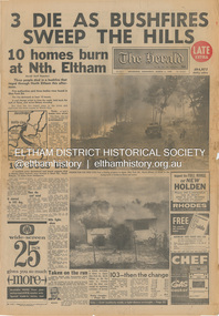
Newspaper - Newspaper articles, The Herald, 3 Die as Bushfires Sweep the Hill: 10 homes burn at Nth. Eltham, The Herald, Wednesday, March 3, p1, 1965
... ...Glen Park Road....) • 10-mile front out of control; Gippsland area ablaze, p3 • Trapped, but saved by wind, p3 Tom Fielding Collection Victorian Bushfires - 1965 Victorian Bushfires – 1965 Eltham North Bert Rodda Glen Park Road Short Road Research (Vic.) Wattle Glen Diamond Creek Warrandyte Eltham Gippsland Mrs G. ...Various news articles pertaining to the January 1965 Victorian bushfires specifically with a focus on fires at Eltham North. Specific Eltham Shire districts mentioned include Eltham North and veteran Herald staff photographer Bert Rodda on page 1 • 3 Die as Bushfires Sweep the Hill: 10 homes burn at Nth. Eltham, p1 (Illust.) • 100 dogs die, p1 • Taken on the run, p1 (Illust.) • Fire runs wild at Eltham, p3 (Illust.) • 10-mile front out of control; Gippsland area ablaze, p3 • Trapped, but saved by wind, p3 tom fielding collection, victorian bushfires - 1965, victorian bushfires – 1965, eltham north, bert rodda, glen park road, short road, research (vic.), wattle glen, diamond creek, warrandyte, eltham, gippsland, mrs g. maher, bill dancy, eltham north store, bushfire damage - buildings -
 Eltham District Historical Society Inc
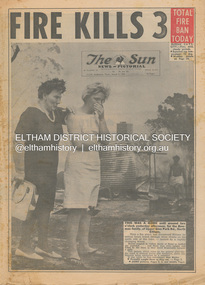
Newspaper - Newspaper articles, Sun News-Pictorial, Fire Kills 3, The Sun News-Pictorial, Thursday, March 4, p1, 1965
... ...Glen Park Road...Tom Fielding Collection Victorian Bushfires - 1965 Victorian Bushfires – 1965 Glen Park Road Eltham North Sunny Pine Bushfire damage – buildings Back Gully Gippsland Glenmaggie Briagolong George John Crowe John Lawrence Coleman William John Elwers Creek Road Wattle Glen Bill Guy Digital scan of original pages from newspaper Fire Kills 3, The Sun News-Pictorial, Thursday, March 4, p1 Newspaper Newspaper articles Sun News-Pictorial ...Various news articles pertaining to the January 1965 Victorian bushfires specifically with a focus on fires at Eltham North. Specific Eltham Shire districts mentioned include Eltham North on page 1, 2, 3, 28-29 • Fire Kills 3, p1 (Illust.) • Fire on their heel, p2 (Illust.) • Flames catch, kill 3 as they run: 12 house go, p3 (Illust.) • It doubled back, p3 • Helpers highly praised, p3 • Blaze kills 100 puppies, p3 (Illust.) • Scenes from Eltham’s Black Wednesday, pp28-29 (Illust.) tom fielding collection, victorian bushfires - 1965, victorian bushfires – 1965, glen park road, eltham north, sunny pine, bushfire damage – buildings, back gully, gippsland, glenmaggie, briagolong, george john crowe, john lawrence coleman, william john elwers, creek road, wattle glen, bill guy -
 Glen Eira Historical Society
Document - Seymour Road, 67, Elsternwick
... Road... Elsternwick... Beemery Park... Glen...Seymour Road Elsternwick Beemery Park Glen Eira Road Orrong Rd Allison Rd Kooyong Rd Beemery Langdon Charles Rosecraddock Park St Nelson Annie Mills Eva Symon Synot Callarhan Margaret Peterson Alexander Peterson DM Bullock Hilary Landells Rosemary Document Seymour Road, 67, Elsternwick ...One typed and one handwritten document on 67 Seymour Road. Document details owners/tenants from 1919 to 1974 and brief history on subdivision from Brighton Historical Society.seymour road, elsternwick, beemery park, glen eira road, orrong rd, allison rd, kooyong rd, beemery, langdon charles, rosecraddock, park st, nelson annie, mills eva, symon synot, callarhan margaret, peterson alexander, peterson dm, bullock hilary, landells rosemary -
Glen Eira Historical Society
Document - Hengar, Glen Eira Road, 356, Elsternwick
... Park... Glen Eira Road...Hengar Happy Days Kindergarten Beemery Park Glen Eira Road Langdon Laura Langdon J K Langdon E LL Langdon Emily Amy Penleigh Sadler Emily Amy Rosecraddock Moxham Mrs Parsons Mrs Holmes Mrs Document Hengar, Glen Eira Road, 356, Elsternwick ...One page of undated, unattributed, handwritten notes giving information about the custom of building a dower house, the history of Hengar’s occupancy and brief information about some of Hengar’s residents. The document also provides a description of a photograph of Hengar and information about social customs relating to the wearing of hats.hengar, happy days kindergarten, beemery park, glen eira road, langdon laura, langdon j k, langdon e ll, langdon emily amy, penleigh, sadler emily amy, rosecraddock, moxham mrs, parsons mrs, holmes mrs -
 Eltham District Historical Society Inc
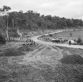
Negative - Photograph, J.A. McDonald, Eltham-Diamond Creek Road, 18 Sep 1959
... ...Glen Park Bridge...Wattletree Road...roads and new bridges constructed within the shire that remain in place as of present day (2022). In many situations, the photos provide a tangible visible record of infrastructure that existed throughout the early days of the Shire. The album was put together by or under the direction of the Shire Engineer, J.A. McDonald. Infrastructure shire of eltham bridge construction 1959-09-18 Bridge Diamond Creek (Creek) Eltham Eltham North Glen Park ...Bridge construction Eltham-Diamond Creek road over the Diamond Creek (Wattletree Road), Eltham, September 1959 After some delay in receiving funds, work started on the bridge approaches in early September 1959. Traffic was still using the old bridge upstream. On Sunday, 20 September 1959, heavy flooding occurred in the stream and at 3:53 pm the old bridge was washed out. This photo was taken the Friday beforeRecord of various Shire of Eltham infrastructure works undertaken during the period of 1952-1962 involving bridge and road reconstruction projects, sometimes with Eltham Shire Council Project Reference numbers quoted. It was during this period that a number of significant improvements were made to roads and new bridges constructed within the shire that remain in place as of present day (2022). In many situations, the photos provide a tangible visible record of infrastructure that existed throughout the early days of the Shire. The album was put together by or under the direction of the Shire Engineer, J.A. McDonald.infrastructure, shire of eltham, bridge construction, 1959-09-18, bridge, diamond creek (creek), eltham, eltham north, glen park bridge, wattletree road bridge -
 Eltham District Historical Society Inc
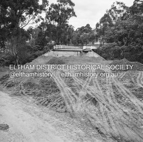
Negative - Photograph, J.A. McDonald, Eltham-Diamond Creek Road, 18 Sep 1959
... ...Glen Park Bridge...Wattletree Road...roads and new bridges constructed within the shire that remain in place as of present day (2022). In many situations, the photos provide a tangible visible record of infrastructure that existed throughout the early days of the Shire. The album was put together by or under the direction of the Shire Engineer, J.A. McDonald. Infrastructure shire of eltham bridge construction 1959-09-18 Bridge Diamond Creek (Creek) Eltham Eltham North Glen Park ...Bridge construction Eltham-Diamond Creek road over the Diamond Creek (Wattletree Road), Eltham, September 1959 After some delay in receiving funds, work started on the bridge approaches in early September 1959. Traffic was still using the old bridge upstream. On Sunday, 20 September 1959, heavy flooding occurred in the stream and at 3:53 pm the old bridge was washed out. This photo was taken the Friday beforeRecord of various Shire of Eltham infrastructure works undertaken during the period of 1952-1962 involving bridge and road reconstruction projects, sometimes with Eltham Shire Council Project Reference numbers quoted. It was during this period that a number of significant improvements were made to roads and new bridges constructed within the shire that remain in place as of present day (2022). In many situations, the photos provide a tangible visible record of infrastructure that existed throughout the early days of the Shire. The album was put together by or under the direction of the Shire Engineer, J.A. McDonald.infrastructure, shire of eltham, bridge construction, 1959-09-18, bridge, diamond creek (creek), eltham, eltham north, glen park bridge, wattletree road bridge -
 Eltham District Historical Society Inc
Album - Photograph Album, J.A. McDonald, Bridge and Road Reconstruction Works, Shire of Eltham, 1952-1962
... Road...Flood damage...floods...Floodwater...Footpaths and gutters...Ford Service Garage...G. Blair...Garden Hill...Glen Park...Wood Fitzsimons Lane Bridge Flat Rock Road Flood damage floods Floodwater Footpaths and gutters Ford Service Garage G. Blair Garden Hill Glen Park Bridge Glenauburn Road Grand Hotel Haldane Road Healesville Healesville-Yarra Glen Road Heidelberg-Kinglake Road Henley Road Bridge Henley Road Hill property Hurstbridge Water scheme Hurstbridge Hurstbridge-Arthurs Creek Road Infrastructure J. ...J.A. McDonald produced this record in the course of his responsibilities as Shire Engineer for Eltham Shire Council.Record of various Shire of Eltham infrastructure works undertaken during the period of 1952-1962 involving bridge and road reconstruction projects, sometimes with Eltham Shire Council Project Reference numbers quoted. It was during this period that a number of significant improvements were made to roads and new bridges constructed within the shire that remain in place as of present day (2022). In many situations, the photos provide a tangible visible record of infrastructure that existed throughout the early days of the Shire. The album was put together by or under the direction of the Shire Engineer, J.A. McDonald.a. gillies, alistair knox park, benchmark studies, bend of islands, blease road, box hill state school, box hill teachers college, box hill tip, bridge construction, bridge street bridge, bridge, brisbane street, brougham steet, bulldozer, cecil street, charis pelling, cherry tree road, city of preston, cr. a. brinkkotter, cr. charis pelling, cranes, cromwell street, diamond creek (creek), diamond street, dixons creek bridge, dixon's creek road, drott, eltham leisure centre, eltham north, eltham police station, eltham, eltham-yarra glen road, f. wood, fitzsimons lane bridge, flat rock road, flood damage, floods, floodwater, footpaths and gutters, ford service garage, g. blair, garden hill, glen park bridge, glenauburn road, grand hotel, haldane road, healesville, healesville-yarra glen road, heidelberg-kinglake road, henley road bridge, henley road, hill property, hurstbridge water scheme, hurstbridge, hurstbridge-arthurs creek road, infrastructure, j. jolly, kangaroo ground, kangaroo ground-queenstown road, kangaroo ground-st andrews road, lilydale shire office, long gully bridge, long gully creek, long gully road, long gully, lower plenty bridge, lower plenty footbridge, lower plenty oval, lower plenty road, lower plenty, main road, methodist church, montmorency, mount pleasant road, new holland, old healesville road, opening ceremony, oxley bridge, para road, paul creek bridge, paul creek road, paul krafeznk, pinnacle lane, plaques, plenty river trail, plenty river, presbyterian church, prof donald thomson, pryor street, railway crossing, railway parade, rattray road, reconstruction works, reichelt avenue, research (vic.), research oval, road construction, rymers corner, shire of eltham, shire of whittlesea, silvan road bridge, silver street bridge, silver street, sir dallas brooks, smedley property, st andrews, steels creek, susan street, tarrawarra, tony carberry, uniting church, upper yarra dam, upper yarra reservoir, w.e. wolf, waterfall property, watsons creek, wattletree road bridge, wattletree road, wattletree road bridge, worlingworth, yarra glen, york street, yow yow creek -
 Eltham District Historical Society Inc
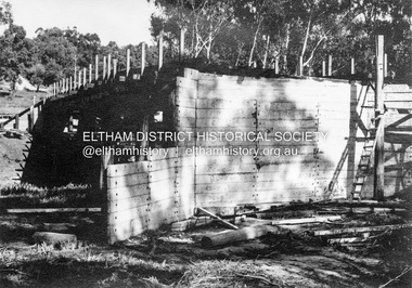
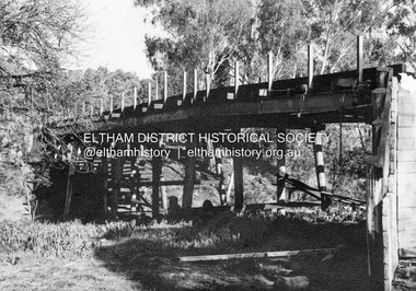
Album - Photograph, J.A. McDonald, Eltham-Diamond Creek Road, Sep. 1959
... Road construction...shire of eltham...bridge construction...Bridge...Diamond Creek (Creek)...Eltham...Eltham North...Glen Park...Infrastructure Road construction shire of eltham bridge construction Bridge Diamond Creek (Creek) Eltham Eltham North Glen Park Bridge Wattletree Road Bridge Black and white photo print (location of negative unknown) Adhered to a page in an album of 78 foolscap pages containing a sequence of photos, adhered via glue or sticky tape, with typed or handwritten headings and captions in pencil. ...Bridge over Diamond Creek Diamond Creek abutment September 1958 Bridge construction Eltham-Diamond Creek road over the Diamond Creek (Wattletree Road), Eltham, Sept 1959Record of various Shire of Eltham infrastructure works undertaken during the period of 1952-1962 involving bridge and road reconstruction projects, sometimes with Eltham Shire Council Project Reference numbers quoted. It was during this period that a number of significant improvements were made to roads and new bridges constructed within the shire that remain in place as of present day (2022). In many situations, the photos provide a tangible visible record of infrastructure that existed throughout the early days of the Shire. The album was put together by or under the direction of the Shire Engineer, J.A. McDonald.infrastructure, road construction, shire of eltham, bridge construction, bridge, diamond creek (creek), eltham, eltham north, glen park bridge, wattletree road bridge -
 Eltham District Historical Society Inc
Album - Photograph, J.A. McDonald, Eltham-Diamond Creek Road, Sep. 1959
... Road construction...shire of eltham...bridge construction...Bridge...Diamond Creek (Creek)...Eltham...Eltham North...Glen Park...Infrastructure Road construction shire of eltham bridge construction Bridge Diamond Creek (Creek) Eltham Eltham North Glen Park Bridge Wattletree Road Bridge Black and white photo print (location of negative unknown) Adhered to a page in an album of 78 foolscap pages containing a sequence of photos, adhered via glue or sticky tape, with typed or handwritten headings and captions in pencil. ...Bridge over Diamond Creek From Diamond Creek abutment September 1958 Bridge construction Eltham-Diamond Creek road over the Diamond Creek (Wattletree Road), Eltham, Sept 1959Record of various Shire of Eltham infrastructure works undertaken during the period of 1952-1962 involving bridge and road reconstruction projects, sometimes with Eltham Shire Council Project Reference numbers quoted. It was during this period that a number of significant improvements were made to roads and new bridges constructed within the shire that remain in place as of present day (2022). In many situations, the photos provide a tangible visible record of infrastructure that existed throughout the early days of the Shire. The album was put together by or under the direction of the Shire Engineer, J.A. McDonald.infrastructure, road construction, shire of eltham, bridge construction, bridge, diamond creek (creek), eltham, eltham north, glen park bridge, wattletree road bridge -
 Eltham District Historical Society Inc
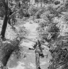
Album - Photograph, J.A. McDonald, Eltham-Diamond Creek Road, 21 Sep. 1959
... Road construction...shire of eltham...bridge construction...Bridge...Diamond Creek (Creek)...Eltham...Eltham North...Glen Park...Infrastructure Road construction shire of eltham bridge construction Bridge Diamond Creek (Creek) Eltham Eltham North Glen Park Bridge Wattletree Road Bridge 1959-09-21 Black and white photo print (location of negative unknown) Adhered to a page in an album of 78 foolscap pages containing a sequence of photos, adhered via glue or sticky tape, with typed or handwritten headings and captions in pencil. ...After some delay in receiving funds, work started on the bridge approaches in early September 1959. Traffic was still using the old bridge upstream. On Sunday, 20 September 1959, heavy flooding occurred in the stream and at 3:53 pm the old bridge was washed out. This photo was taken the day after. Here is what did the damage lying between the two bridges.Record of various Shire of Eltham infrastructure works undertaken during the period of 1952-1962 involving bridge and road reconstruction projects, sometimes with Eltham Shire Council Project Reference numbers quoted. It was during this period that a number of significant improvements were made to roads and new bridges constructed within the shire that remain in place as of present day (2022). In many situations, the photos provide a tangible visible record of infrastructure that existed throughout the early days of the Shire. The album was put together by or under the direction of the Shire Engineer, J.A. McDonald.infrastructure, road construction, shire of eltham, bridge construction, bridge, diamond creek (creek), eltham, eltham north, glen park bridge, wattletree road bridge, 1959-09-21 -
 Whitehorse Historical Society Inc.
Document, Forest Hill new home sites, 1/02/1995 12:00:00 AM
... park...glen valley road...land subdivision glenview park glen valley road forest hill pratico court springvale road fletcher and parker forest hill primary school Advertising 22 new home sites off Glen Valley Road, near the corner of Springvale and Canterbury Roads, Forest Hill Brochure advertising 22 new home sites off Glen Valley Road, near the corner of Springvale and Canterbury Roads, Forest Hill on the former Forest Hill Primary School site (closed 1993). ...Advertising 22 new home sites off Glen Valley Road, near the corner of Springvale and Canterbury Roads, Forest HillBrochure advertising 22 new home sites off Glen Valley Road, near the corner of Springvale and Canterbury Roads, Forest Hill on the former Forest Hill Primary School site (closed 1993).Advertising 22 new home sites off Glen Valley Road, near the corner of Springvale and Canterbury Roads, Forest Hillland subdivision, glenview park, glen valley road, forest hill, pratico court, springvale road, fletcher and parker, forest hill primary school -
 Greensborough Historical Society
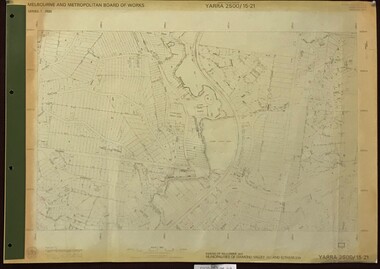
Map, Melbourne and Metropolitan Board of Works. Survey Division, MMBW, Yarra 2500 / 15.21. Eltham North, 1979_08
... Prominent streets include: Progress Road, Glen Park Road and Zig Zag Road. Features include the Diamond Creek, Eltham Council Pound and Eltham North Reserve....Prominent streets include: Progress Road, Glen Park Road and Zig Zag Road. Features include the Diamond Creek, Eltham Council Pound and Eltham North Reserve. mmbw melbourne and metropolitan board of works shire of diamond valley nillumbik eltham - maps MMBW Map in 1:2500 [scale] series. ...Melbourne and Metropolitan Board of Works. Yarra 2500 [base map] 15.21. Eltham North. Parish of Nillumbik 3310. Municipalities of Diamond Valley 257 and Eltham 238. Prominent streets include: Progress Road, Glen Park Road and Zig Zag Road. Features include the Diamond Creek, Eltham Council Pound and Eltham North Reserve.MMBW Map in 1:2500 [scale] series. Cream parchment with green tape reinforcing on edges and punched holes on left edge.mmbw, melbourne and metropolitan board of works, shire of diamond valley, nillumbik, eltham - maps -
 Eltham District Historical Society Inc
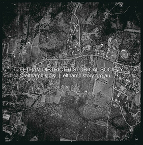
Photograph - Aerial Photograph, Landata, Eltham, Vic, Apr. 1963
... Centred on present day Floriston Grove, Eltham bounded by Maroondah Aqueduct to north, Thompson Crescent and Diosma Road to south, Research Shops to east and Glen Park Road and Park West Road to west. Historic Aerial Imagery Source: Landata.vic.gov.au Aerial Photo Details: Project No :486 Project : MELBOURNE (1963) PROJECT Run : 5 Frame : 60 Date : 04/1963 Film Type : B/W Camera : RC8 Flying Height : 5100 Scale : 9600 Film Number : 1805 GDA2020 : 37°42'24"S, 145°09'29"E MGA2020 : 337622, 5825128 (55) Melways : 22 B3 (ed. 42)...Centred on present day Floriston Grove, Eltham bounded by Maroondah Aqueduct to north, Thompson Crescent and Diosma Road to south, Research Shops to east and Glen Park Road and Park West Road to west. Historic Aerial Imagery Source: Landata.vic.gov.au Aerial Photo Details: Project No :486 Project : MELBOURNE (1963) PROJECT Run : 5 Frame : 60 Date : 04/1963 Film Type : B/W Camera : RC8 Flying Height : 5100 Scale : 9600 Film Number : 1805 GDA2020 : 37°42'24"S, 145°09'29"E MGA2020 : 337622, 5825128 (55) Melways : 22 B3 (ed. 42) Aerial Photo Neil Webster Collection Eltham 1963-04 Diosma Road Floriston Grove Maroondah Aqueduct Melway 22B3 Park West Road Research (Vic.) ...Centred on present day Floriston Grove, Eltham bounded by Maroondah Aqueduct to north, Thompson Crescent and Diosma Road to south, Research Shops to east and Glen Park Road and Park West Road to west. Historic Aerial Imagery Source: Landata.vic.gov.au Aerial Photo Details: Project No :486 Project : MELBOURNE (1963) PROJECT Run : 5 Frame : 60 Date : 04/1963 Film Type : B/W Camera : RC8 Flying Height : 5100 Scale : 9600 Film Number : 1805 GDA2020 : 37°42'24"S, 145°09'29"E MGA2020 : 337622, 5825128 (55) Melways : 22 B3 (ed. 42)aerial photo, neil webster collection, eltham, 1963-04, diosma road, floriston grove, maroondah aqueduct, melway 22b3, park west road, research (vic.), research shops -
 Eltham District Historical Society Inc
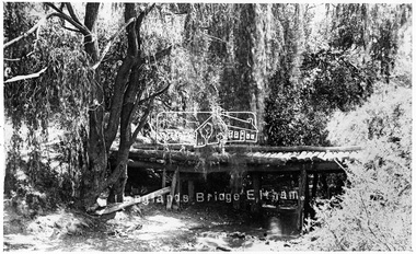
Negative - Photograph, Tom Prior, Langlands Bridge, Eltham, c.1900
... Glen Park Estate’. It is possible that the bidge may have crossed the Diamond Creek to Langland's land along the original alignment of Glen Park Road which used to run between present day Progress Road and Coleman Crescent. ...Glen Park Estate’. It is possible that the bidge may have crossed the Diamond Creek to Langland's land along the original alignment of Glen Park Road which used to run between present day Progress Road and Coleman Crescent. ...It is noted in the Reynolds Prior collection (Ivy Reynolds) as the first bridge in Eltham however given the current state of knowledge, this is considered unlikely and there is no other supporting source. John Hunter Langlands, owner of the farm known as ‘Ihurst’ on the west side of Diamond Creek to the south of John Wright Murray’s land, died in 1907. In 1909 his land was subdivided into 100 lots to become the ‘Glen Park Estate’. It is possible that the bidge may have crossed the Diamond Creek to Langland's land along the original alignment of Glen Park Road which used to run between present day Progress Road and Coleman Crescent. SEPP Source (c.1970): Mrs. E.R. Reynolds, Thompson Crescent, Research The Reynolds family were early settlers in Research. The Reynolds/ Prior collection of photographs were taken by Tom Prior, the maternal uncle of Ivy Reynolds, around 1900 and the 60 photos in the album give a fine overview of many of the landmarks of Research and Eltham over 100 years ago. lvy lived in the family home for many years at 106 Thompson Cres Research. Ivy's father, Ernst Richard Reynolds and grandfather, Richard Reynolds, lived at the same address. Ivy's father Richard worked for Mr. Trail on his property in Research. Reynolds Road is named after the family. Mr Tom Prior (wife Eva) worked at the Melbourne zoo. He was very innovative and made his own camera, using the black cloth hood to exclude the light. The photographs are a reminder of the rural nature of Research and Eltham and its rich heritage. This photo forms part of a collection of photographs gathered by the Shire of Eltham for their centenary project book,"Pioneers and Painters: 100 years of the Shire of Eltham" by Alan Marshall (1971). The collection of over 500 images is held in partnership between Eltham District Historical Society and Yarra Plenty Regional Library (Eltham Library) and is now formally known as the 'The Shire of Eltham Pioneers Photograph Collection.' It is significant in being the first community sourced collection representing the places and people of the Shire's first one hundred years.Digital image 4 x 5 inch B&W Neg B&W printsepp, shire of eltham pioneers photograph collection, eltham, langlands bridge, reynolds prior collection, bridge, john hunter langlands -
 Glen Eira Historical Society
Article - Hopetoun Gardens
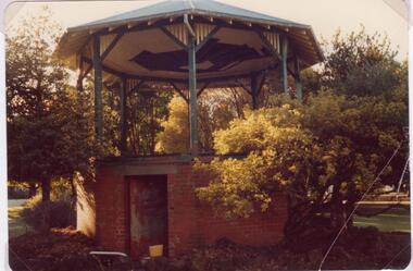
... One is a black and white photocopy of a photograph of the cannon, with three children, possibly from 1910. 6/Two colour photographs dated 15/05/2009, of the bandstand at Railway Reserve, which is to be moved to a new park in Glen Huntly Road. 7/Two colour photographs of the bandstand and playground equipment at Hopetoun Gardens, dated by hand on “c. 2000” 8/Printed four page booklet (two copies), no date (c. 2000?) ...One is a black and white photocopy of a photograph of the cannon, with three children, possibly from 1910. 6/Two colour photographs dated 15/05/2009, of the bandstand at Railway Reserve, which is to be moved to a new park in Glen Huntly Road. 7/Two colour photographs of the bandstand and playground equipment at Hopetoun Gardens, dated by hand on “c. 2000” 8/Printed four page booklet (two copies), no date (c. 2000?) ...This file contains eleven items about these Gardens: 1/Handwritten note from Pam Harrison of Monash University dated 15/06/2005, stating that she is sending the Glen Eira Historical a collection of items from her aunt, whose husband worked for Caulfield Council. Stapled together with a typed acknowledgment from Hazel Ford, Hon. Secretary of the Society dated 15/07/2005. 2/Typed letter from Walter A. Coxen of Queenscliff to (unnamed) Mayor of Caulfield, dated 14/04/1910, stating that he encloses information about the two eighty pound rifled muzzle loading guns now at Hopetoun Gardens, with more recently typed shot description of “The Cannon of Hopetoun Gardens.” Also included is a typed page dated 14/04/1910, signed by Mr Coxen on “Particulars of the two eighty-PR guns presented to the Caulfield Town Council”. 3/Two undated black and white photographs showing garden beds at Hopetoun Gardens. 4/Typed letter from Lt.-Col M.P.J. O’Brien, President, Fort Queenscliff Museum, dated 05/09/1984, to R-Ballantine, Hon. Secretary of the Caulfield Historical Society, stating that he would be happy to assist in tracing the history of the cannons in Hopetoun Gardens. 5/Photographs of the cannon at Hopetoun Gardens. Four are recent colour photographs, one dated 06/1981. One is a black and white photograph, undated (mid-1930s?), with a man sitting on the cannon. One is a black and white photocopy of a photograph of the cannon, with three children, possibly from 1910. 6/Two colour photographs dated 15/05/2009, of the bandstand at Railway Reserve, which is to be moved to a new park in Glen Huntly Road. 7/Two colour photographs of the bandstand and playground equipment at Hopetoun Gardens, dated by hand on “c. 2000” 8/Printed four page booklet (two copies), no date (c. 2000?) of “Your Guide to Hopetoun Gardens – Interpretative Tree Walk”, printed by the Glen Eira City Council Recreation Services. 9/One colour negative (two copies of each) of swimming at Hopetoun Gardens, no date 10/Printed emails of correspondence dated from 26/08/2012 to 02/10/2012, to and from the Glen Eira historical Society, about the cannons at Hopetoun Gardens. 11/Article from Glen Eira News dated March/April 2013 about the history of the cannons with a coloured photograph.hopetoun gardens, harrison pam, ford hazel, coxen walter adam, cannons, parks, fort queenscliff, elsternwick, bandstands, glen eira recreation services, trees, triarico elizabeth, dunbar margaret, rogers john (fleet engineer) -
 Eltham District Historical Society Inc
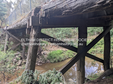
Photograph, Tess Justine (Nillumbik Shire Council), Murray's Bridge over the Diamond Creek, Eltham North, 19 Feb 2022
... The bluestone siding you reference may well have been built by Murray as part of the proposed station platform. • Up until then, apart from the Main Road bridge, which was washed away in 1924, virtually all local crossings over the Diamond Creek were low lying bridges – Kaylocks Bridge at Brougham Street, Diamond Street bridge, Glen Park Road bridge. It is expected that Murray also had a low-lying bridge to connect his land either side of the creek. ...The bluestone siding you reference may well have been built by Murray as part of the proposed station platform. • Up until then, apart from the Main Road bridge, which was washed away in 1924, virtually all local crossings over the Diamond Creek were low lying bridges – Kaylocks Bridge at Brougham Street, Diamond Street bridge, Glen Park Road bridge. It is expected that Murray also had a low-lying bridge to connect his land either side of the creek. ...Murray's Bridge over the Diamond Creek on the Diamond Creek Trail just prior to demolition and replacement with a new steel bridge. Heritage advice obtained by Nillumbik Shire Council, following a suggestion by the Eltham District Historical Society (EDHS), is that the original bridge appears to have been a simplified version of the Country Roads Board’s (CRB) standard timber bridge design of the early-to-mid 1920s. In c1990 Murray’s bridge was renovated with three recycled steel girders as part of a bike/pedestrian path in the reserve. During these alterations many parts of the bridge were removed, and some were replaced. Heritage advice indicates the condition of Murray’s bridge is poor. The remaining original parts are all in poor condition, with severe weathering, splitting and rot, especially to the stringers retained on the bridge. Heritage advice is that Murray’s Bridge does not have sufficient significance in the cultural history of the Nillumbik area to warrant inclusion in the Nillumbik Shire Heritage Overlay and also does not have sufficient significance as a rare survivor to warrant inclusion in the Nillumbik Shire Heritage Overlay. There are no indications in the historical record that this site was individually important to the cultural history of this area. EDHS is comfortable with the heritage advice provided to Council and has worked closely on this project with Council. EDHS has suggested some of the removed timbers be used in the vicinity of the bridge for landscaping and possibly seating, so as to retain these remnants close to the site of the original bridge, which is the last old timber bridge along the lower reaches of the Diamond Creek. Mary (Sweeney) Murray and John Wright Murray selected 80 acres, Lot C Section 16 and Lot 5 Section 17 Parish of Nillumbik, under an occupation license in 1866. John died in 1867 and freehold was granted to his son John in 1873. The farm was known as ‘Laurel Hill’. John Junior was an Eltham Shire councillor and sometime president from 1887 up until 1897. He added Lot A Section 16 to the farm in ca1888. John and his younger brother James arranged to rent/purchase Lot B Section 17, across Diamond Creek to the west, in ca1900. It appears that John and James farmed separately for a few years, with a new homestead built for James ad family on the high point of Lot B Section 17 in ca1910. John sold off Lot 5 Section 17 in 1912. When John died in 1912 James took over the land on both sides of the Diamond Creek. The old homestead on the west side of the Creek disappeared. A farm bridge over Diamond Creek from this period may have been located close to the northern boundary of the farm. John Langlands, owner of the farm known as ‘Ihurst’ on the west side of Diamond Creek to the south of the Murray’s land, died in 1907. In 1909 his land was then subdivided into 100 lots to become the ‘Glen Park Estate’. Other similar subdivisions of nineteenth century farms around Eltham in this period included the ‘Franktonia (or Beard’s) Estate’ to the northeast and ‘Bonsack’s Estate’ between Eltham and Greensborough. Soon after the opening of the railway extension line from Eltham to Hurstbridge in 1912, Glen Park and nearby residents including James Murray agitated for a railway station or siding to be located half-way between Eltham and Hurstbridge, so that the Glen Park residents who used the railway daily did not have to walk into the Eltham or Hurstbridge stations. Some believed Coleman’s Corner (opposite Edendale Farm) was an appropriate spot for the platform. James Murray was among those who thought the railway should be located on his land, closer to half-way between Eltham and Hurstbridge stations. The Railways Commissioners warned that the locals would have to fund these works themselves. The Glen Park Estate residents initially had difficulty accessing Eltham by road, with only an old low-level bridge over Diamond Creek at the south end of their estate. A new timber trestle bridge across the creek, now on Wattletree Road, was opened in 1915. Road access to the north was gained in 1927 when the new Murray’s Road, which crossed the Murray’s land, was built. Residents continued to agitate for a Glen Park station. By 1926 the Railways Commissioners’ preferred site was on the Murray’s land. They arranged an estimate of cost of a full-length platform. The estimate was too much for the locals, who in 1928 argued unsuccessfully for a shorter and hence cheaper platform. By 1929 Murray had agreed to donate the land, but the locals would still have to fund the works. Murray decided, unilaterally it would appear, to commence work on a timber trestle road bridge over Diamond Creek to link the new Murray Road to the proposed station. Late in 1929 he stopped work on the bridge, for reasons unknown, but started work again and completed the bridge in 1931. There is no further newspaper evidence of the campaign for the Glen Park station until 1939, when Murray and another local, Mr Maxwell, met the Railways Commissioner. The Glen Park locale now included 45 homes on the west side of the creek and 20 on the Eltham side. Most of the residents used the train every day. The Commissioner remained adamant that only a full-length platform could be built for safety reasons. It appears the campaign dissolved at this point. The increasing move to cars may have had an impact. There is no evidence of Murray’s bridge ever being connected to Murray’s Road, or of it having wide use for any purpose by locals. James Murray died in 1947 and the farm was taken over by his son James (Jim). Jim started to sell off parts of the farm in the 1980s, retaining a few acres around the ca1910 homestead and building a new house there. Recreation reserves were established along the creek. In ca1990 Murray’s bridge was renovated with steel girders as part of a bike/pedestrian path in the reserve. The old farmhouse was demolished in ca2014. * * * A theory posted on local community Facebook groups was that the bridge was built in the 1860s and was built to be more robust than was necessary for the movement of cows from one side of the creek to the other. It was suggested the robustness was necessary to support the weight of gold ore being transferred from a mine on Murray’s land to a railway siding near Murrays Bridge (presumably for transfer and processing at Diamond Creek). Perhaps this may have been one of the motivators for Murray, who really knows? Knowing when mining operations ceased on his land and how that fits the overall timeline would be useful but at the time the bridge was built, local gold production was minimal at best. The known facts are: • The railway line came to Eltham in 1902. • The extension of the railway from Eltham to Hurstbridge was constructed in 1912 so no railway line even existed through Murray's property until 1912 and the Victorian Railways maps at the time show no such siding on Murray’s property. • In 1923 a new company was formed in anticipation of the old Diamond Creek Gold Mine being re-opened. The mine had been previously closed and flooded. It was noted in the press at the time that the mine was within a mile of the railway. Nothing really came of this. • Construction of Murrays Bridge was commenced by James Murray in early 1929 in anticipation of a proposed flag station being nominated on his land, but work ceased shortly afterwards. The proposed flag station was commonly referred to as Glen Park as the residents of the Glen Park Estate wanted Option 1, located near them with the platform adjacent to Colemans corner. This was probably never going to fly as it was virtually in eyesight of Eltham station. Allandale Road was the third option, but the Commissioners' preferred option was No. 2 - on Murray's property. • The Railway Commissioners were not going to finance any such station and the works had to be funded by private landowners and residents, hence Murray investing in this himself. • Murray recommenced work two years later and finished his bridge in 1931 but unfortunately for him, the proposed flag station never eventuated. The bluestone siding you reference may well have been built by Murray as part of the proposed station platform. • Up until then, apart from the Main Road bridge, which was washed away in 1924, virtually all local crossings over the Diamond Creek were low lying bridges – Kaylocks Bridge at Brougham Street, Diamond Street bridge, Glen Park Road bridge. It is expected that Murray also had a low-lying bridge to connect his land either side of the creek. These were all washed away or severely damaged multiple times in the 1920s. Lessons were learnt, and Murrays Bridge appears to have been built in accordance with Country Road Board standards of the time. Flood damage was ongoing, and even more recently constructed raised bridges kept getting washed away, e.g., the new Wattle Tree Road bridge in 1958 just months after completion. Murray’s bridge was reinforced with steel some 30 years ago presumably to provide additional floodwater resistance, given the history of bridges disappearing in floodwaters. • In March 1932 it was reported in the Advertiser that there were still some prospectors operating around Eltham North who apart from further scarring the face of the earth over the previous two years had gained significant experience but little gold - hardly a driving factor for constructing a dedicated railway siding and bridge to transfer gold ore. It is far more probable that James Murray was hoping to have the railway station located on his property and invested his money by building the bridge to lead to it as well as a station platform. Had the station eventuated, it may well have driven up the value of his land for subdivision and new housing estates like the Glen Park Estate. That did not eventuate. Whilst the bridge was indeed old (90 years), the core structure being completed in 1931, it had been modified substantially from original and hence had no significant historic value – i.e., it was not a representative example of its type, construction, and age. Given that the bridge was not worthy of saving, the Eltham District Historical Society with Council’s support, and the Eltham Woodworkers group endeavoured to see what suitable sized timbers were salvageable to fabricate a commemorative seat. Unfortunately, the experts at the Woodworkers group were unable to salvage any suitable length/width timbers to fabricate the seat due to the presence of rot. Last remaining wooden trestle bridge on the Diamond Creek Trail just prior to demolition and replacementBorn digital image (27)diamond creek (creek), diamond creek trail, murrays bridge, ‘laurel hill’, john wright murray, mary (sweeney) murra, john murray jnr, james murray, john langlands, ‘ihurst’, ‘glen park estate’, beard's estate, franktonia, bonsack's estate, glen park estate, glen park railway station -
 City of Moorabbin Historical Society (Operating the Box Cottage Museum)
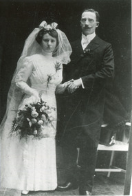
Photograph, B/W, x3 Wedding August & Frieda Rietmann 1910 and Certicicate, 1910,1915
... Road Highett in 1953 and later to Carrum. The land, containing the Box Cottage, was sold to Lewis Timber Pty Ltd in 1970 and Mr Lewis proposed that Moorabbin City Council should preserve the heritage Cottage. In 1984 the Cottage was dismantled and reconstructed in the adjacent Joyce Park. The Rietman family is an example of the diverse nationalities that lived and worked productively in Moorabbin Shire 1871–1933 , the City of Moorabbin 1934-1994 and continues today in the Cities of Glen ...August Rietmann (1877-1951) of Lustdorf ,Switzerland, married Maria Frieda Oesschlager (2/21878- 22/7/1942) of Baden Baden, Germany on 6/8/1910 In 1915 August and his wife Frieda migrated to Melbourne, Victoria, Australia. They leased Box Cottage, Ormond in 1917 and raised two children, Stefanie (1918 -2006) and William (1920- 1997). 1935 August purchased the property and the family used the Cottage during the day and slept in the Front House. August was a monumental mason, potter and sculptor, and was employed at Corbens Ltd Clifton Hill, to carve war memorials in Victoria post WW1 c 1915-1922. During the 1920's August set up his own business in pressed cement making pot plants, columns,paving slabs and lampstands. He continued to carve headstones and figures and took contract work for Artists eg Paul Mountford. He built a workshop in the Barn and used the Cottage for plaster moulding. His son William joined the business and and the family continued to use the site after August died in 1951. Rietman's Landscaping Ltd moved to Bay Road Highett in 1953 and later to Carrum. The land, containing the Box Cottage, was sold to Lewis Timber Pty Ltd in 1970 and Mr Lewis proposed that Moorabbin City Council should preserve the heritage Cottage. In 1984 the Cottage was dismantled and reconstructed in the adjacent Joyce Park.The Rietman family is an example of the diverse nationalities that lived and worked productively in Moorabbin Shire 1871–1933 , the City of Moorabbin 1934-1994 and continues today in the Cities of Glen Eira, Kingston, Bayside, and Monash. August, a sculptor and stone mason, was employed by Corben Pty Ltd Clifton Hill to carve WW1 Memorials before establishing his own successful masonry business in the Box Cottage during the latter 1920s. After becoming interested in pressed cement casting, he took on apprentices (1930s Depression) and among his products were garden furniture, pots and also street lamp standards, some of which were installed in St Kilda Road. After August’s death in 1951, his family continued the business ‘Rietman’s Landscaping Ltd.’, at Highett and Carrum.a) Photograph Black & White August & Frieda Rietmann Wedding 6/8/1910 in Baden Baden ; b) Passport Photograph August Rietmann 1915; c) Photograph Frieda Rietmann 1915; d) Document Wedding Certificate August & Frieda Rietmann Baden Baden 1910a) b) c) Handwritten information d) Official Document in Germanrietmann august, rietman august, rietmann frieda, rietman frieda, stonnington city town hall, war memorials, world war 1 1914-1918, rietman stefanie, rennick stefanie, francis stefanie, rietman william, rietman ray, mountford paul, malvern city town hall,box cottage museum ormond, box william, box elizabeth, joyce park ormond, rietman's landscaping pty ltd, bay road highett, macrobertson pty ltd, coleraine soldier memorial 1921, -
 City of Moorabbin Historical Society (Operating the Box Cottage Museum)
Documents, x3 Printed, Census Lustdorf 1914,15, Swiss Citizen Pass1915, 1914-1915
... Road Highett in 1953 and later to Carrum. The land, containing the Box Cottage, was sold to Lewis Timber Pty Ltd in 1970 and Mr Lewis proposed that Moorabbin City Council should preserve the heritage Cottage. In 1984 the Cottage was dismantled and reconstructed in the adjacent Joyce Park. The Rietman family is an example of the diverse nationalities that lived and worked productively in Moorabbin Shire 1871–1933 , the City of Moorabbin 1934-1994 and continues today in the Cities of Glen ...August Rietmann (1877-1951) of Lustdorf ,Switzerland, married Maria Frieda Oesschlager (2/21878- 22/7/1942) of Baden Baden, Germany on 6/8/1910 In 1915 August and his wife Frieda migrated to Melbourne, Victoria, Australia. They leased Box Cottage, Ormond in 1917 and raised two children, Stefanie (1918 -2006) and William (1920- 1997). 1935 August purchased the property and the family used the Cottage during the day and slept in the Front House. August was a monumental mason, potter and sculptor, and was employed at Corbens Ltd Clifton Hill, to carve war memorials in Victoria post WW1 c 1915-1922. During the 1920's August set up his own business in pressed cement making pot plants, columns,paving slabs and lampstands. He continued to carve headstones and figures and took contract work for Artists eg Paul Mountford. He built a workshop in the Barn and used the Cottage for plaster moulding. His son William joined the business and and the family continued to use the site after August died in 1951. Rietmann Landscaping Ltd moved to Bay Road Highett in 1953 and later to Carrum. The land, containing the Box Cottage, was sold to Lewis Timber Pty Ltd in 1970 and Mr Lewis proposed that Moorabbin City Council should preserve the heritage Cottage. In 1984 the Cottage was dismantled and reconstructed in the adjacent Joyce Park. The Rietman family is an example of the diverse nationalities that lived and worked productively in Moorabbin Shire 1871–1933 , the City of Moorabbin 1934-1994 and continues today in the Cities of Glen Eira, Kingston, Bayside, and Monash. August, a sculptor and stone mason, was employed by Corben Pty Ltd Clifton Hill to carve WW1 Memorials before establishing his own successful masonry business in the Box Cottage during the latter 1920s. After becoming interested in pressed cement casting, he took on apprentices (1930s Depression) and among his products were garden furniture, pots and also street lamp standards, some of which were installed in St Kilda Road. After August’s death in 1951, his family continued the business ‘Rietman’s Landscaping Ltd.’, at Highett and Carrum.Documents a) Census 1914 Household Register Lustdorf, Switzerland; b) Census 1915 Household Register Lustdorf, Switzerland; c) Swiss Confederation Citizen ship I.D Pass Frieda Rietman 4/8/1915;Printed Government Documents in Swiss Language lustdorf switzerland, rietmann august, rietman august, rietmann frieda, rietman frieda, stonnington city town hall, war memorials, world war 1 1914-1918, rietman stefanie, rennick stefanie, francis stefanie, rietman william, rietman ray, mountford paul, malvern city town hall,box cottage museum ormond, box william, box elizabeth, joyce park ormond, rietman's landscaping pty ltd, bay road highett, macrobertson pty ltd, coleraine soldier memorial 1921,, box cottage museum ormond -
 City of Moorabbin Historical Society (Operating the Box Cottage Museum)
Photographs, x 2 B/W Rietmann Family c1920's, c1920s
... Road Highett in 1953 and later to Carrum. The land, containing the Box Cottage, was sold to Lewis Timber Pty Ltd in 1970 and Mr Lewis proposed that Moorabbin City Council should preserve the heritage Cottage. In 1984 the Cottage was dismantled and reconstructed in the adjacent Joyce Park. The Rietman family is an example of the diverse nationalities that lived and worked productively in Moorabbin Shire 1871–1933 , the City of Moorabbin 1934-1994 and continues today in the Cities of Glen ...August Rietmann (1877-1951) of Lustdorf ,Switzerland, married Maria Frieda Oesschlager (2/2/1878- 22/7/1942) of Baden Baden, Germany on 6/8/1910 In August 8th 1915 August and his wife Frieda migrated to Melbourne, Victoria, Australia sailing on the Steam Ship ‘Osterley’ from Marseilles to Melbourne They leased Box Cottage, Ormond in 1917 and raised two children, Stefanie (1918 -2006) and William (1920- 1997). 1935 August purchased the property and the family used the Cottage during the day and slept in the Front House. August was a monumental mason, potter and sculptor, and was employed at Corbens Ltd Clifton Hill, to carve war memorials in Victoria post WW1 c 1915-1922. During the 1920's August set up his own business in pressed cement making pot plants, columns,paving slabs and lampstands. He continued to carve headstones and figures and took contract work for Artists eg Paul Mountford. He built a workshop in the Barn and used the Cottage for plaster moulding. His son William joined the business and and the family continued to use the site after August died in 1951. Rietmann Landscaping Ltd moved to Bay Road Highett in 1953 and later to Carrum. The land, containing the Box Cottage, was sold to Lewis Timber Pty Ltd in 1970 and Mr Lewis proposed that Moorabbin City Council should preserve the heritage Cottage. In 1984 the Cottage was dismantled and reconstructed in the adjacent Joyce Park. The Rietman family is an example of the diverse nationalities that lived and worked productively in Moorabbin Shire 1871–1933 , the City of Moorabbin 1934-1994 and continues today in the Cities of Glen Eira, Kingston, Bayside, and Monash. August, a sculptor and stone mason, was employed by Corben Pty Ltd Clifton Hill to carve WW1 Memorials before establishing his own successful masonry business in the Box Cottage during the latter 1920s. After becoming interested in pressed cement casting, he took on apprentices (1930s Depression) and among his products were garden furniture, pots and also street lamp standards, some of which were installed in St Kilda Road. After August’s death in 1951, his family continued the business ‘Rietman’s Landscaping Ltd.’, at Highett and Carrum.Photographs x2 Black & White of August and Frieda Rietmann with children and friends at Ormond and Sorrento in 1920sHand written a) at Ormond 1921 ; b) at Sorrento c 1920'ssorrento beach victoria, box cottage museum, ormond, rietmann august, rietman august, rietmann frieda, rietman frieda, stonnington city town hall, war memorials, world war 1 1914-1918, rietman stefanie, rennick stefanie, francis stefanie, rietman william, rietman ray, mountford paul, malvern city town hall, box cottage museum ormond, box william, box elizabeth, joyce park ormond, rietman's landscaping pty ltd, bay road highett, macrobertson pty ltd, coleraine soldier memorial 1921
