Showing 63 items matching "glen valley road"
-
 Whitehorse Historical Society Inc.
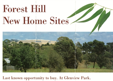
Document, Forest Hill new home sites, 1/02/1995 12:00:00 AM
... ...glen valley road...Brochure advertising 22 new home sites off Glen Valley Road, near the corner of Springvale and Canterbury Roads, Forest Hill on the former Forest Hill Primary School site (closed 1993)....Whitehorse Historical Society Inc. 2-10 Deep Creek Road Mitcham melbourne land subdivision glenview park glen valley road forest hill pratico court springvale road fletcher and parker forest hill primary school Advertising 22 new home sites off Glen Valley Road, near the corner of Springvale and Canterbury Roads, Forest Hill Brochure advertising 22 new home sites off Glen Valley Road, near the corner of Springvale and Canterbury Roads, Forest Hill on the former Forest Hill Primary School site (closed 1993). ...Advertising 22 new home sites off Glen Valley Road, near the corner of Springvale and Canterbury Roads, Forest HillBrochure advertising 22 new home sites off Glen Valley Road, near the corner of Springvale and Canterbury Roads, Forest Hill on the former Forest Hill Primary School site (closed 1993).Advertising 22 new home sites off Glen Valley Road, near the corner of Springvale and Canterbury Roads, Forest Hillland subdivision, glenview park, glen valley road, forest hill, pratico court, springvale road, fletcher and parker, forest hill primary school -
 Camberwell Historical Society
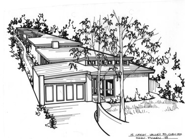
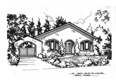
Drawing (series) - Architectural drawing, 15 Great Valley Road, Glen Iris, 1988
... 15 Great Valley Road, Glen Iris...Pen and ink architectural drawing on drafting film of 15 Great Valley Road, Glen Iris by Margaret Picken...VALLEY RD., GLEN IRIS / MARG. PICKEN '88 Pen and ink architectural drawing on drafting film of 15 Great Valley Road, Glen Iris by Margaret Picken 15 Great Valley Road, Glen Iris Drawing Architectural drawing ...artist, architectural drawings, margaret picken, camberwell, housesartist, architectural drawings, margaret picken, camberwell, houses -
 Camberwell Historical Society
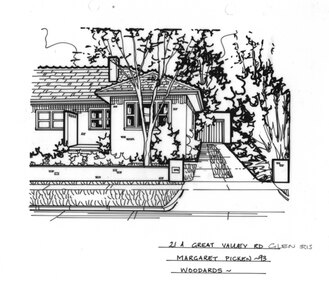
Drawing (series) - Architectural drawing, 21A Great Valley Road, Glen Iris, 1993
... 21A Great Valley Road, Glen Iris...Pen and ink architectural drawing on drafting film of 21A Great Valley Road, Glen Iris by Margaret Picken...The fact that each drawing is dated with the year it was created also proves a valuable record for house historians - since that date a number of the depicted properties have either been altered or demolished. artist architectural drawings margaret picken camberwell houses 21A GREAT VALLEY RD., GLEN IRIS / MARGARET PICKEN - 93 / WOODARDS - Pen and ink architectural drawing on drafting film of 21A Great Valley Road, Glen Iris by Margaret Picken 21A Great Valley Road, Glen Iris Drawing Architectural drawing ...artist, architectural drawings, margaret picken, camberwell, housesartist, architectural drawings, margaret picken, camberwell, houses -
 Camberwell Historical Society
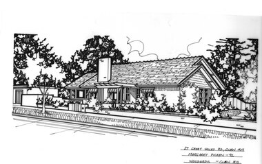
Drawing (series) - Architectural drawing, 27 Great Valley Road, Glen Iris, 1992
... 27 Great Valley Road, Glen Iris...Pen and ink architectural drawing on drafting film of 27 Great Valley Road, Glen Iris by Margaret Picken...The fact that each drawing is dated with the year it was created also proves a valuable record for house historians - since that date a number of the depicted properties have either been altered or demolished. artist architectural drawings margaret picken camberwell houses 27 GREAT VALLEY RD., GLEN IRIS / MARGARET PICKEN - 92 / WOODARDS - GLEN IRIS Pen and ink architectural drawing on drafting film of 27 Great Valley Road, Glen Iris by Margaret Picken 27 Great Valley Road, Glen Iris Drawing Architectural drawing ...artist, architectural drawings, margaret picken, camberwell, housesartist, architectural drawings, margaret picken, camberwell, houses -
 Camberwell Historical Society
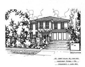
Drawing (series) - Architectural drawing, 40 Great Valley Road, Glen Iris, 1997
... 40 Great Valley Road, Glen Iris...Pen and ink architectural drawing on drafting film of 40 Great Valley Road, Glen Iris by Margaret Picken...The fact that each drawing is dated with the year it was created also proves a valuable record for house historians - since that date a number of the depicted properties have either been altered or demolished. artist architectural drawings margaret picken camberwell houses 40 GREAT VALLEY RD., GL IRIS / MARGARET PICKEN - 97 / WOODARDS Pen and ink architectural drawing on drafting film of 40 Great Valley Road, Glen Iris by Margaret Picken 40 Great Valley Road, Glen Iris Drawing Architectural drawing ...artist, architectural drawings, margaret picken, camberwell, housesartist, architectural drawings, margaret picken, camberwell, houses -
 Camberwell Historical Society
Drawing (series) - Architectural drawing, 40 Great Valley Road, Glen Iris, 1992
... 40 Great Valley Road, Glen Iris...Pen and ink architectural drawing on drafting film of 40 Great Valley Road, Glen Iris by Margaret Picken...The fact that each drawing is dated with the year it was created also proves a valuable record for house historians - since that date a number of the depicted properties have either been altered or demolished. artist architectural drawings margaret picken camberwell houses 40 GREAT VALLEY RD., GLEN IRIS / MARGARET PICKEN - 92 / WOODARDS - GLEN IRIS Pen and ink architectural drawing on drafting film of 40 Great Valley Road, Glen Iris by Margaret Picken 40 Great Valley Road, Glen Iris Drawing Architectural drawing ...artist, architectural drawings, margaret picken, camberwell, housesartist, architectural drawings, margaret picken, camberwell, houses -
 Camberwell Historical Society
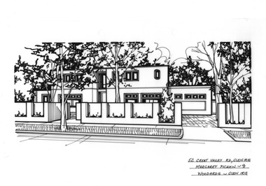
Drawing (series) - Architectural drawing, 52 Great Valley Road, Glen Iris, 1991
... 52 Great Valley Road, Glen Iris...Pen and ink architectural drawing on drafting film of 52 Great Valley Road, Glen Iris by Margaret Picken...The fact that each drawing is dated with the year it was created also proves a valuable record for house historians - since that date a number of the depicted properties have either been altered or demolished. artist architectural drawings margaret picken camberwell houses 52 GREAT VALLEY RD., GLEN IRIS / MARGARET PICKEN - 91 / WOODARDS - GLEN IRIS Pen and ink architectural drawing on drafting film of 52 Great Valley Road, Glen Iris by Margaret Picken 52 Great Valley Road, Glen Iris Drawing Architectural drawing ...artist, architectural drawings, margaret picken, camberwell, housesartist, architectural drawings, margaret picken, camberwell, houses -
 Camberwell Historical Society
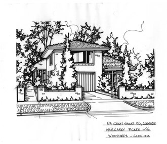
Drawing (series) - Architectural drawing, 53 Great Valley Road, Glen Iris, 1996
... 53 Great Valley Road, Glen Iris...Pen and ink architectural drawing on drafting film of 53 Great Valley Road, Glen Iris by Margaret Picken...The fact that each drawing is dated with the year it was created also proves a valuable record for house historians - since that date a number of the depicted properties have either been altered or demolished. artist architectural drawings margaret picken camberwell houses 53 GREAT VALLEY RD., GLEN IRIS / MARGARET PICKEN - 96 / WOODARDS - GLEN IRIS Pen and ink architectural drawing on drafting film of 53 Great Valley Road, Glen Iris by Margaret Picken 53 Great Valley Road, Glen Iris Drawing Architectural drawing ...artist, architectural drawings, margaret picken, camberwell, housesartist, architectural drawings, margaret picken, camberwell, houses -
 Camberwell Historical Society
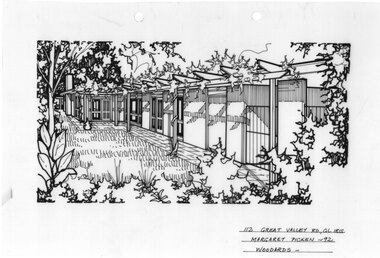
Drawing (series) - Architectural drawing, 112 Great Valley Road, Glen Iris, 1992
... 112 Great Valley Road, Glen Iris...Pen and ink architectural drawing on drafting film of 112 Great Valley Road, Glen Iris by Margaret Picken...IRIS / MARGARET PICKEN - 92 / WOODARDS - Pen and ink architectural drawing on drafting film of 112 Great Valley Road, Glen Iris by Margaret Picken 112 Great Valley Road, Glen Iris Drawing Architectural drawing ...artist, architectural drawings, margaret picken, camberwell, housesartist, architectural drawings, margaret picken, camberwell, houses -
 Camberwell Historical Society
Drawing (series) - Architectural drawing, 114 Great Valley Road, Glen Iris, Unknown
... 114 Great Valley Road, Glen Iris...Pen and ink architectural drawing on drafting film of 114 Great Valley Road, Glen Iris by Margaret Picken...VALLEY RD., GLEN IRIS / MARG. PICKEN Pen and ink architectural drawing on drafting film of 114 Great Valley Road, Glen Iris by Margaret Picken 114 Great Valley Road, Glen Iris Drawing Architectural drawing ...artist, architectural drawings, margaret picken, camberwell, housesartist, architectural drawings, margaret picken, camberwell, houses -
 Whitehorse Historical Society Inc.
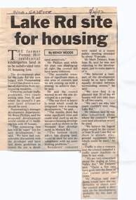
Article, Lake Rd Site for Housing, 8/04/1992 12:00:00 AM
... ...glen valley road...Whitehorse Historical Society Inc. 2-10 Deep Creek Road Mitcham melbourne land subdivision forest hill residential kindergarten lake road forest hill jean street phillips bruce delaney mark glen valley road Lake Rd Site for Housing. An article in the Nunawading Gazette on an objection by Mark Delaney on the traffic flow and hazards associated with the proposed development of land on the former Forest Hill Residential Kindergarten land. ...Lake Rd Site for Housing.An article in the Nunawading Gazette on an objection by Mark Delaney on the traffic flow and hazards associated with the proposed development of land on the former Forest Hill Residential Kindergarten land.Lake Rd Site for Housing.land subdivision, forest hill residential kindergarten, lake road, forest hill, jean street, phillips, bruce, delaney, mark, glen valley road -
 Whitehorse Historical Society Inc.
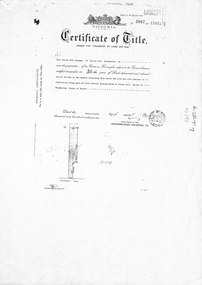
Document, Forest Hill, 24/08/1932
... ...glen valley road...Whitehorse Historical Society Inc. 2-10 Deep Creek Road Mitcham melbourne draeger carl julius otto canterbury road forest hill glen valley road lovell lydia esther lillian sarah frances brown william john mabel jessie Photocopy of Certificate of Title Photocopy of Certificate of Title Vol 5807 Fol 1161261 to Carl Julius Otto Draeger for four acres of land being part of Crown Portion 93 at Forest Hill; with verso of C/T Vol 1900 Fol 37984 recording transfers to Lydia Esther Lovell, Lillian Sarah Frances Lovell, William John and Mabel Jessie Brown. ...Photocopy of Certificate of TitlePhotocopy of Certificate of Title Vol 5807 Fol 1161261 to Carl Julius Otto Draeger for four acres of land being part of Crown Portion 93 at Forest Hill; with verso of C/T Vol 1900 Fol 37984 recording transfers to Lydia Esther Lovell, Lillian Sarah Frances Lovell, William John and Mabel Jessie Brown.Photocopy of Certificate of Title draeger, carl julius otto, canterbury road, forest hill, glen valley road, lovell, lydia esther, lillian sarah frances, brown, william john, mabel jessie -
 Canterbury History Group
Article, Scottish connection, 26/04/1988 12:00:00 AM
... Valley Road... Morris Family... Canterbury Jack... Fuel Merchants... Towers... Glen...Real estate advertisement for the auction of "Glen Morag" 10 Wattle Valley Road Canterbury on Saturday 7 May 1988. ...Canterbury History Group 190A Canterbury Road Canterbury melbourne Canterbury Wattle Valley Road Morris Family Canterbury Jack Fuel Merchants Towers Glen Morag Real estate advertisement for the auction of "Glen Morag" 10 Wattle Valley Road Canterbury on Saturday 7 May 1988. ...Real estate advertisement for the auction of "Glen Morag" 10 Wattle Valley Road Canterbury on Saturday 7 May 1988. This was the home of "Canterbury Jack" (Morris) well known local fuel merchant..canterbury, wattle valley road, morris family, canterbury jack, fuel merchants, towers, glen morag -
 Emerald Museum & Nobelius Heritage Park
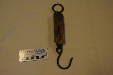
Orchadist Scales, Donated by Frank Eckerman (Emerald)
... Emerald Museum & Nobelius Heritage Park 5 Crichton Rd Emerald yarra-valley-and-the-dandenong-ranges Used in orchards by Harry Shaw (Orchardist in Springvale Rd, Glen Waverley near cnr Highbury Road) Orchard was sold in 1950. ...Used in orchards by Harry Shaw (Orchardist in Springvale Rd, Glen Waverley near cnr Highbury Road) Orchard was sold in 1950. Later used on poultry farm in Forest Hills.Body of scales: brass plate inscribed - Salter Pocket Balance, made in England. No.3. To weigh 50LB. Slide measure 0 to 50. Pattern at top: twisted rope with arrow through middle. Reverse side: green painted metal. Hanging metal ring at top end and metal hook at lower end. Salter Pocket Balance, Made in England. No.3. To weigh 50LB. -
Eltham District Historical Society Inc
Document - Folder, Smith, Samuel
... Glen: Samuel Smith and Eliza Hurst. Photocopy of page from magazine National Trust Australia (Vic), no date (possibly 1993). Keith Smith closed his butcher shop, Kew, and donated equipment to National Trust, possibly to go to Gulf Station. Newspaper article: "Smith family's fortunes yielded to modern technology - in 1850", Diamond Valley News, 10 March 1987. Samuel Smith Eliza Hurst Keith Smith Gulf Station Yarra Glen James Smith Queenstown St Andrews Sarah Smith Richard Smith Mary Smith Edwin Smith Thomas Smith John Smith Ralph Smith Marjorie Smith Motshall Wild Wood Days at Panton Hill book Louisa Purcell St Andrews church Queenstown Cherry tree Road Panton Hill Beaumont house Panton Hill Edwin James Samuel Smith Violet Bartlett Ethel May Smith Mary Louise Smith Violet Smtih Fred Smith Alan Smith Cemetery Smiths Gully Road St Andrews Russell Smith Joan Smith Joyce Smith Ethel Smith Grand Hotel Yarra Glen Newspaper clippings, A4 photocopies, etc Smith, Samuel Document Folder ...Samuel Smith came to Australia about 1849 with his wife and family, settling at Queenstown and, with the gold rush, established an abattoir. A descendant, Marjorie Smith Motschall wrote about the family in 'Wild WoodDays at Panton Hill'. Many descendants have lived in and around Eltham. The family had four generations of butchers, including Keith, who had a shop in Kew. Contents Photocopy of handwritten notes: Samuel Smith biography. Typed version of handwritten notes: Samuel Smith biography. Letter L Adam to Eltham Shire, 6 March 1884. Seeking information about the Smith family in Yarra Glen: Samuel Smith and Eliza Hurst. Photocopy of page from magazine National Trust Australia (Vic), no date (possibly 1993). Keith Smith closed his butcher shop, Kew, and donated equipment to National Trust, possibly to go to Gulf Station. Newspaper article: "Smith family's fortunes yielded to modern technology - in 1850", Diamond Valley News, 10 March 1987. Newspaper clippings, A4 photocopies, etcsamuel smith, eliza hurst, keith smith, gulf station yarra glen, james smith, queenstown, st andrews, sarah smith, richard smith, mary smith, edwin smith, thomas smith, john smith, ralph smith, marjorie smith motshall, wild wood days at panton hill book, louisa purcell, st andrews church queenstown, cherry tree road panton hill, beaumont house panton hill, edwin james samuel smith, violet bartlett, ethel may smith, mary louise smith, violet smtih, fred smith, alan smith, cemetery smiths gully road st andrews, russell smith, joan smith, joyce smith, ethel smith, grand hotel yarra glen -
 Eltham District Historical Society Inc
Albert Jones, 'Golden Glen', home of photographer, Albert Jones
... The house at the far end and middle building in the photo remain as of 2024, located at 205 Kangaroo Ground-Wattle Glen Rd, Kangaroo Ground between Pretty Hill Lane and Millers Road. https://maps.app.goo.gl/riyy56LsfEMz4w5W6 Reproduced in The Diamond Valley Story, Dianne H Edwards, The Shire of Diamond Valley 1979, p138 "Golden Glen, the home at Wattle Glen of photographer and orchardist Albert Jones. ...The house at the far end and middle building in the photo remain as of 2024, located at 205 Kangaroo Ground-Wattle Glen Rd, Kangaroo Ground between Pretty Hill Lane and Millers Road. https://maps.app.goo.gl/riyy56LsfEMz4w5W6 Reproduced in The Diamond Valley Story, Dianne H Edwards, The Shire of Diamond Valley 1979, p138 "Golden Glen, the home at Wattle Glen of photographer and orchardist Albert Jones. ...At the right of the photo is an apple orchard over the other side of Watery Gully creek. The house at the far end and middle building in the photo remain as of 2024, located at 205 Kangaroo Ground-Wattle Glen Rd, Kangaroo Ground between Pretty Hill Lane and Millers Road. https://maps.app.goo.gl/riyy56LsfEMz4w5W6 Reproduced in The Diamond Valley Story, Dianne H Edwards, The Shire of Diamond Valley 1979, p138 "Golden Glen, the home at Wattle Glen of photographer and orchardist Albert Jones. It was in one of these outbuildings that the hundreds of glass negatives of the Spark/Jones Collection werer found. Phot: Spark/Jones Collection" See Ref: EDHS_03112 A WINDOW ON THE PAST by Roger Sanders, The Sun, Wednesday, Auguist 11, 1976, pp 38-39 A fascinating window has been opened on the early life of the Eltham district. It is a rare collection of 3,000 perfectly preserved glass plate photograph negatives. The collection is the work of the late Albert Jones, a Diamond Creek orchardist and amateur photographer. About 500 of the negatives have been printed and 100 are on display at Gallery 4, Eltham, as part of the Eltham Festival," which started on Friday. They capture in fine detail rural and village life around Eltham, Hurstbridge, Kangaroo Ground, Yarra Glen and Diamond Valley from 1900 to 1930. While the natural beauty of the district was painted in this period by Arthur Streeton (later Sir Arthur), Tom Roberts and Charles Conder, among others, photography was relatively new. Yet Albert Jones used the new medium to compile a weighty album of pioneers at work, at home, at sport and on holidays. He was at the first Yarra Glen race meeting, early Diamond Valley football matches and photographed soldiers from the district leaving for war. He photographed early gold mines, men with horses laying the Diamond Creek-Hurstbridge rail track and the arrival of the first steam train at Hurstbridge. He took his cameras on holiday around Victoria and the collection includes scenes from St. Kilda and Portsea and many country towns. The Jones collection of negatives was found by Mr A. J. "Ned" Spark, of Balwyn, under a house he bought from Mr Jones' widow. The plates almost went to the tip with a pile of rubbish before Mr Spark realised their potential value. Mr Spark, who is retired, will continue the identification and recording of the photographs when he returns from holidays. The exhibition of the Jones' photographs is open each afternoon until August 21 at Gallery 4, 1016 Main Rd., Eltham. Photographs included in article: • The priceless collection of glass plate negatives were found under this house in Eltham [actually Wattle Glen], home of Albert Jones and his wife. • A quiet country pub - Panton Hills Hotel. • Teams of draught horses were used in the building of the Diamond Creek-Hursbridge railway in 1910. • Chinaman Jimmy using a gold cradle in Wattle Glen Gully. • The photographer and orchardist Albert Jones. His work is on show as part of the Eltham Festival • St Kilda Pier – several of the houses are still standing, but the waterfront has changed dramatically since this was taken before 1920. • A picnic was a dressy affair at the start of the century – the women in this family group are decked in lace and pearls.Stamped in purple ink on reverse within border "A.J. SPARK COLLECTION PHOTOS 1900 - 1930 PHOTOGHRAPHER LATE ALBERT JONES DIAMOND VALLEY. TEL: 83-3561"a.j. spark collection, albert jones, golden glen, shops, wattle glen -
Eltham District Historical Society Inc
Document - Folder, Stevenson, Joseph
... Valley Leader, 23 November 2005. Lynette Beale traced her ancestor Joseph Stevenson to Kangaroo Ground. Letter Diana Bassett-Smith to EDHS, 10 August 2005. Donation of a moulding plane marked Joseph Stephenson, property of descendants. Joseph Stevenson ship Willington 1837 Ruth Stevenson nee Boyd David Stevenson Jane Stevenson Kirk's Bazaar First punt across Yarra River Princes Bridge Melbourne Stevenson Street Melbourne Saltwater Creek River Plenty Christmas Hills David Christmas Diamond Creek Isabella Stevenson Robert Stevenson Five Mill Creek Watson's Creek "Bankhead" Kangaroo Ground Ellen Stevenson Yarra Glen Road Yarra Glen Cemetery Stevenson's Corner Kangaroo Ground Stevenson's Creek Presbyterian Church Kangaroo Ground Eltham District Road Board Margaret Stevenson Ruth Stevenson Emma Stevenson nee Peers Margaret Hargreaves nee Stephenson Robert Peers Cyrus Peers Charlotte Peers Jane Mess nee Stevenson Robert Mess Pearl Mess nee Mills James Mess George Mess Janet Mess Joseph Mess William Mess Alexander Mess Barbara Mess Isabella Mess Ruth Gosling nee Mess John Gosling Jessie Gosling Evelyn Sinclair nee Gosling William Gosling Vera Rowland nee Gosling Florrie Rawland Ethel Rawland John Rawland Isobel Gilson nee Mess Bruce Mess Joy Mess nee Masefield Janet Crook nee Mess Rodney Crook Judith Rodgers nee Mess Ray Rodgers Dean Crook Jenine Crooks Carolyn Rodgers Merryn Rodgers Beryl Nansen nee Mess Robert Nansen Gerry Oliming Roberta Oliming nee Nansen Bernard Nansen Michele Nansen nee Blackie Rohan Nansen Janet Nansen nee Britton Vera Cope nee Mess Cliff Cope Graeme Cope Louise Cope nee Thimpton Shannon Cope Lucas Cope Peter Cope Marilyn Cope nee Turnley Oliver Cope Sarah Cope Kelvin Cope Donald Mess Joan Mess Geoffrey Mess Peter Mess Rosemary Mess Kerrie Mess Isobel Gibson nee Mess Ellen Stevenson nee Armstrong James Stevenson John Stevenson Elizabeth Stevenson Joanna Stevenson Ellen Little nee Stevenson william Little Francis Little Janet Little nee Armstrong Ruth Lorimer nee Little David Lorimer Ruth Cameron nee Lorimer Francis Lorimer Val Wade Elizabeth Lorimer David Kelso Willaim Lorimer Jean Lorimer nee Hewitt Nancy Mitson nee Lorimer Stan Mitson John Hewitt Alison Hewitt John Cameron Beryl Ryan nee Cameron Robert Cameron Maryann Ryan Peter Ryan Margaret ryan Steven Wade Andrew Wade Jonathan Wade Jennifer Wade Ruth Sadlernee Stevenson Thomas Sadler Alexander Sadler Isabella Booth nee Sadler Angus Sadler Heather Sadler Ruth Sadler Andrew Sadler Nancy Sadler Benjamin Sadler Robert Sadler Alice Sadler nee Smith Margaret Smith David Sadler Anne McClusky nee Sadler Hope Sadler Anne Carson nee Sadler Ruth Edwards nee Carson David Carson Joseph Sadler Isabella Bond nee Sadler Ian Bond Ruth Bond Isabella Bond John Sadler thoas Sadler Mary Sadler nee Stewart Stewart Sadler Keith Sadler Glen Sadler Peter Sadler Terry Sadler Pamela Sadler Armstrong family Kangaroo Ground Bell family Kangaroo Ground Rogerson family Kangaroo Ground Barr family Kangaroo Ground Harkness family Kangaroo Ground Jardin family Kangaroo Ground Thompson family Kangaroo Ground Johnson family Kangaroo Ground Walters family Kangaroo Ground Sir Ewen Camerson Flora Margaret Cameron Ewen Cameron Sir Ewan Camerson Sir Herbert Gepp "Garden Hill" Yarra Glen Road Andrew Moss Museum Kangaroo Ground Lynette Beale Noel Beale Mick woiwod Diana Bassett-Smith Newspaper clippings, A4 photocopies, etc Stevenson, Joseph Document Folder ...Joseph Stevenson came to Australia in 1837, eventually settling near Kangaroo Ground. He was active in local affairs.. Contents Handwritten and typed notes by Winifred Joy Ness, 1985, "Joseph Stevenson of Kangaroo Ground". Handwritten extracts from "Pioneers and Painters" by Alan Marshall, relevant to Joseph Stevenson. Handwritten extracts from "Pastoral Pioneers of Port Phillip"by R V Bills and A S Kenyon, relevant to Joseph Stevenson. Photocopy of photographs: Stevenson daughters; a stevenson daughter with baby; Joseph Stevenson. Handwritten Stevenson family tree (on 2 sheets). Photocopy of photograph: Robert Stevenson and family, "Bankhead", Kangaroo Ground (ref 423). Photocopy of two prints/paintings, annotated on reverse (information from R B Ness: Punt over Yarra River at Melbourne which Joseph Stevenson helped build, from "History of South Melbourne", published 1930s; First bridge over Yarra at Melbourne which Joseph Stevenson helped build. Photocopy of Death Certificate: Joseph Stevenson, 1 November 1878. Photocopy of Death Certificate: Ruth Sevenson, 1 November 1868. Photocopy of Marriage Certificate: names illegible 16 November 1868 Photocopy of extract of Marriage Certificate: Joseph Stephenson and Ruth Boyd, 14 June 1837. Newspaper article: "Resting in peace", Diamond Valley News, 23 March 1982. Judith Furphy and early Kangaroo Ground families buried in Kangaroo Ground Cemetery. Newspaper article: "Grounds for celebration", Diamond Valley Leader, 23 November 2005. Lynette Beale traced her ancestor Joseph Stevenson to Kangaroo Ground. Letter Diana Bassett-Smith to EDHS, 10 August 2005. Donation of a moulding plane marked Joseph Stephenson, property of descendants.Newspaper clippings, A4 photocopies, etcjoseph stevenson, ship willington 1837, ruth stevenson nee boyd, david stevenson, jane stevenson, kirk's bazaar, first punt across yarra river, princes bridge melbourne, stevenson street melbourne, saltwater creek, river plenty, christmas hills, david christmas, diamond creek, isabella stevenson, robert stevenson, five mill creek, watson's creek, "bankhead" kangaroo ground, ellen stevenson, yarra glen road, yarra glen cemetery, stevenson's corner kangaroo ground, stevenson's creek, presbyterian church kangaroo ground, eltham district road board, margaret stevenson, ruth stevenson, emma stevenson nee peers, margaret hargreaves nee stephenson, robert peers, cyrus peers, charlotte peers, jane mess nee stevenson, robert mess, pearl mess nee mills, james mess, george mess, janet mess, joseph mess, william mess, alexander mess, barbara mess, isabella mess, ruth gosling nee mess, john gosling, jessie gosling, evelyn sinclair nee gosling, william gosling, vera rowland nee gosling, florrie rawland, ethel rawland, john rawland, isobel gilson nee mess, bruce mess, joy mess nee masefield, janet crook nee mess, rodney crook, judith rodgers nee mess, ray rodgers, dean crook, jenine crooks, carolyn rodgers, merryn rodgers, beryl nansen nee mess, robert nansen, gerry oliming, roberta oliming nee nansen, bernard nansen, michele nansen nee blackie, rohan nansen, janet nansen nee britton, vera cope nee mess, cliff cope, graeme cope, louise cope nee thimpton, shannon cope, lucas cope, peter cope, marilyn cope nee turnley, oliver cope, sarah cope, kelvin cope, donald mess, joan mess, geoffrey mess, peter mess, rosemary mess, kerrie mess, isobel gibson nee mess, ellen stevenson nee armstrong, james stevenson, john stevenson, elizabeth stevenson, joanna stevenson, ellen little nee stevenson, william little, francis little, janet little nee armstrong, ruth lorimer nee little, david lorimer, ruth cameron nee lorimer, francis lorimer, val wade, elizabeth lorimer, david kelso, willaim lorimer, jean lorimer nee hewitt, nancy mitson nee lorimer, stan mitson, john hewitt, alison hewitt, john cameron, beryl ryan nee cameron, robert cameron, maryann ryan, peter ryan, margaret ryan, steven wade, andrew wade, jonathan wade, jennifer wade, ruth sadlernee stevenson, thomas sadler, alexander sadler, isabella booth nee sadler, angus sadler, heather sadler, ruth sadler, andrew sadler, nancy sadler, benjamin sadler, robert sadler, alice sadler nee smith, margaret smith, david sadler, anne mcclusky nee sadler, hope sadler, anne carson nee sadler, ruth edwards nee carson, david carson, joseph sadler, isabella bond nee sadler, ian bond, ruth bond, isabella bond, john sadler, thoas sadler, mary sadler nee stewart, stewart sadler, keith sadler, glen sadler, peter sadler, terry sadler, pamela sadler, armstrong family kangaroo ground, bell family kangaroo ground, rogerson family kangaroo ground, barr family kangaroo ground, harkness family kangaroo ground, jardin family kangaroo ground, thompson family kangaroo ground, johnson family kangaroo ground, walters family kangaroo ground, sir ewen camerson, flora margaret cameron, ewen cameron, sir ewan camerson, sir herbert gepp, "garden hill" yarra glen road, andrew moss museum kangaroo ground, lynette beale, noel beale, mick woiwod, diana bassett-smith -
Eltham District Historical Society Inc
Document - Folder, Macmillan, Donald
... Glen School. Later Hugh carried mail from South Yan Year (now Mernda) to Arthurs Creek School (also the post office); he was Sunday School teacher at the Arthurs Creek Methodist Church. Hugh married Helena Heatley from New Zealand who managed the farm after Hugh died, growing fruit and vegetables, carted by wagon to the Victoria Market. Their firstborn was Ken. Contents Newspaper article: "Donald MacMillan - a romantic", Diamond Valley News, 29 October 1985, pp30-31; history of MacMillan family. Newspaper article: "An alternative road...Glen School. Later Hugh carried mail from South Yan Year (now Mernda) to Arthurs Creek School (also the post office); he was Sunday School teacher at the Arthurs Creek Methodist Church. Hugh married Helena Heatley from New Zealand who managed the farm after Hugh died, growing fruit and vegetables, carted by wagon to the Victoria Market. Their firstborn was Ken. Contents Newspaper article: "Donald MacMillan - a romantic", Diamond Valley News, 29 October 1985, pp30-31; history of MacMillan family. Newspaper article: "An alternative road ...Donald MacMillan (widower) with his six children eft Inverness, Scotland, in 1849, and worked as a shepherd on Plenty River property of Captain Aneas McPerson, under the manager Thomas Walker. MacMillan married again and son Hugh was born 1860, first of another six children. They lived at Morang but, in 1866, selected land at Arthurs Creek. Hugh and his sister Ann attended the Hazel Glen School. Later Hugh carried mail from South Yan Year (now Mernda) to Arthurs Creek School (also the post office); he was Sunday School teacher at the Arthurs Creek Methodist Church. Hugh married Helena Heatley from New Zealand who managed the farm after Hugh died, growing fruit and vegetables, carted by wagon to the Victoria Market. Their firstborn was Ken. Contents Newspaper article: "Donald MacMillan - a romantic", Diamond Valley News, 29 October 1985, pp30-31; history of MacMillan family. Newspaper article: "An alternative road to happiness", Diamond Valley News, 29 October 1985, p29; Mic Webb's travels and philosophy, now living at Hurstbridge.Newspaper clippings, A4 photocopies, etcdonald macmillan, plenty river victoria, captain aneas mcpherson, thomas walker, morang victoria, arthurs creek victoria, ann macmillan, hazel glen school victoria, south yan yean victoria, mernda victoria, arthurs creek school victoria, arthurs creek methodist church, malcolm macmillan, helena macmillan nee heatley, ken macmillan, mic webb, hurstbridge learning co-op, hurstbridge victoria, cottlesbridge victoria, st andrews victoria -
 Eltham District Historical Society Inc
Photograph - Digital Photograph, Marguerite Marshall, Strathewen Public Hall, 20 August 2008
... Road and upper Arthurs Creek. He called it Carseburn after his home parish in Scotland. Tragically in 1875 John drowned in the Yarra River, at Richmond.3 John Mann’s oldest son, also John, later purchased Duncan Smith’s land, which he named Violet Glen. He was to give one acre (0.4ha) of this land for the Strathewen Hall site. A Mann family diary written at Carseburn in 1897, tells how the district’s name was selected. Strathewen is derived from ‘strath’ meaning ‘broad mountain valley...Road and upper Arthurs Creek. He called it Carseburn after his home parish in Scotland. Tragically in 1875 John drowned in the Yarra River, at Richmond.3 John Mann’s oldest son, also John, later purchased Duncan Smith’s land, which he named Violet Glen. He was to give one acre (0.4ha) of this land for the Strathewen Hall site. A Mann family diary written at Carseburn in 1897, tells how the district’s name was selected. Strathewen is derived from ‘strath’ meaning ‘broad mountain valley ...Strathewen Public Hall, social and spiritual centre was later lost in the Black Saturday fires 2009. The Strathewen Community decided a community hall was needed in 1901. In 1902 locals built the hall with messmate trees. It was located on the Cottlesbridge-Strathewen Road. The first function was a Grand concert and Balll attended by about 120 people. Several denominations held Church services and Sunday School services in the Hall. It survived several bushfires until after this photo was taken when it was destroyed in Black Saturday, 9 February 2009. Published: Nillumbik Now and Then / Marguerite Marshall 2008; photographs Alan King with Marguerite Marshall.; p89 Strathewen was settled late, largely because it was difficult to access.1 Early selectors found it a struggle to survive. They had to do everything themselves, from felling trees for buildings, to taking produce to market along bush tracks that they had helped cut. Small dairy farms were typical but fruit became the district’s prime produce. The first settlers east of Arthurs Creek were brothers John and Duncan Smith whose station Glen-Ard was probably operated as a sheep run. Other early settlers were the Mann family, who were to donate land for the hall, provide postal services and John Mann was an Eltham Shire councillor from 1916 to 1919.2 In 1873 James Mann, his wife Jane and their six children, settled on 207 acres (83.7) (Lang Fauld Farm) on both sides of Eagles Nest Road, from the foot of Mount Sugarloaf to the bank of the Arthurs Creek. In 1883 James took up another selection on Chads Creek. It was very hard work and at times he was well behind with his rent. However the family had a good social life, attending the Primitive Methodist Church at the Arthurs Creek Township and on New Year’s Eve throwing a party for all the locals. By 1874 James Mann’s younger brother, John, selected 311 acres (125.8ha) between Eagles Nest Road and upper Arthurs Creek. He called it Carseburn after his home parish in Scotland. Tragically in 1875 John drowned in the Yarra River, at Richmond.3 John Mann’s oldest son, also John, later purchased Duncan Smith’s land, which he named Violet Glen. He was to give one acre (0.4ha) of this land for the Strathewen Hall site. A Mann family diary written at Carseburn in 1897, tells how the district’s name was selected. Strathewen is derived from ‘strath’ meaning ‘broad mountain valley’ and from the name of Ewen H. Cameron, the local parliamentarian for almost 40 years. ‘George Brain came around to get a petition signed to get a post office up here and we had to vote for a name—Strathewen, Glen-Ard, or Headcorie’.4 It was at Carseburn that a public meeting in 1901, decided to build the Strathewen Hall on the Cottlesbridge-Strathewen Road. In 1902 the locals built the hall with messmate trees. The first function was a Grand Concert and Ball attended by around 120 people and several Protestant denominations took turns to hold church services and Sunday School there. Fortunately the hall has survived bushfires to be the town’s spiritual and social centre.5 The area continued to develop and in 1909 a post office operated somewhere at Strathewen and from around 1916 at Carseburn.6 It was not until 1914 that land was bought to establish the Strathewen State School on School Ridge Road. The residents paid £100 to build it on two acres (0.8 ha) while the Education Department contributed £30 and leased the building annually for £1. When teacher Miss Mary Golding opened the school in 1917, it had no equipment.7 But in 1921 the Education Department provided desks and a hexagonal shelter shed (now a rare style in Victoria) and took control in 1925.8 By 1917 Strathewen was booming.9 George Apted had built a coolstore in 1916, and local orchardists bought storage space until the 1950s. This allowed the area to supply the market in and out of season. Guesthouses catered for growing tourism. In the mid 1920s Mrs Eleanor Sparkes built the guest-house Singing Waters, which operated through the 1930s. Her daughter Mrs Vera McKimmie, ran it until the 1950s and the house remains in Chads Creek Road. In the Great Depression land was cleared for timber to be sold as firewood and there was small scale sawmilling. However the orchard industry diminished for several reasons including the 1939 bushfires and rapid changes in production methods. Today the Apteds still operate an orchard and farm at Glen-Ard, which straddles the border between Strathewen and Arthurs Creek. It includes the southern part of Duncan Smith’s original Glen-Ard selection.This collection of almost 130 photos about places and people within the Shire of Nillumbik, an urban and rural municipality in Melbourne's north, contributes to an understanding of the history of the Shire. Published in 2008 immediately prior to the Black Saturday bushfires of February 7, 2009, it documents sites that were impacted, and in some cases destroyed by the fires. It includes photographs taken especially for the publication, creating a unique time capsule representing the Shire in the early 21st century. It remains the most recent comprehenesive publication devoted to the Shire's history connecting local residents to the past. nillumbik now and then (marshall-king) collection, strathewan public hall -
 Greensborough Historical Society
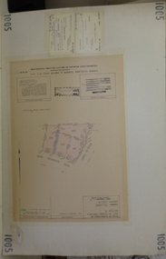
Planning document, Subdivision Plan #1005. Corner Douglas Court and Glen Katherine Drive Greensborough, 1981_
... Road Lower Plenty Lower Plenty melbourne Plan of Subdivision. Corner Douglas Court and Glen Katherine Drive Greensborough. An example of hard copy subdivision plans from the Greensborough area. Mainly from the Shire of Diamond Valley ...Plan of Subdivision. Corner Douglas Court and Glen Katherine Drive Greensborough.An example of hard copy subdivision plans from the Greensborough area. Mainly from the Shire of Diamond Valley era (1964-1994).Plan (2 sheets) mounted on heavy card.Stamped and handwritten Council permissions, dates and other details.subdivision plans, douglas court, glen katherine drive -
 Greensborough Historical Society
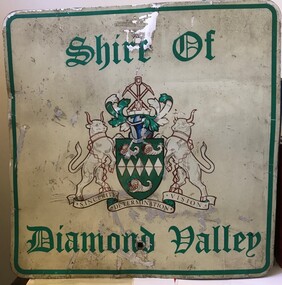
Sign - Boundary Sign, Shire of Diamond Valley, Shire of Diamond Valley boundary sign, 1990s
... Valley was a Local Government Area located about 20 kilometres northeast of Melbourne. The shire covered an area of 74.38 square kilometres and existed from 1964 until 1994. This example of a Boundary Sign was one of many located on the edge of the Shire e.g. at Wattle Glen Station; at Yan Yean Road north of Bannons Lane; 2 on Plenty Road near Larundel and Bundoora Primary School; one on the Para Road bridge; on Wattletree Road Eltham and on Kurrak Road Yarrambat. ...Greensborough Historical Society 34A Glenauburn Road Lower Plenty Lower Plenty melbourne The Shire of Diamond Valley was a Local Government Area located about 20 kilometres northeast of Melbourne. The shire covered an area of 74.38 square kilometres and existed from 1964 until 1994. This example of a Boundary Sign was one of many located on the edge of the Shire e.g. at Wattle Glen ...The Shire of Diamond Valley was a Local Government Area located about 20 kilometres northeast of Melbourne. The shire covered an area of 74.38 square kilometres and existed from 1964 until 1994. This example of a Boundary Sign was one of many located on the edge of the Shire e.g. at Wattle Glen Station; at Yan Yean Road north of Bannons Lane; 2 on Plenty Road near Larundel and Bundoora Primary School; one on the Para Road bridge; on Wattletree Road Eltham and on Kurrak Road Yarrambat. According to a former Shire employee, the signs were often stolen as quickly as they were replaced. This sign was removed when the Shire of Diamond Valley was dissolved in 1994 and is signed by a Shire employee, giving it strong provenance.Painted metal sign, cream background with green text and Shire of Diamond Valley crest.Inscribed in felt tip pen on back of sign: SDV: from Nov 1964 to 1994. 30 years. Ron Middleton, By-laws Officer and Ranger, from 9/84 to Nov 94 [signed] R. Middletonshire of diamond valley, boundary signs -
 Greensborough Historical Society
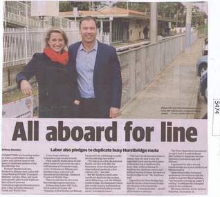
Newspaper Clipping, Diamond Valley Leader, All aboard for line, 08/08/2018
... Greensborough Historical Society 34A Glenauburn Road Lower Plenty Lower Plenty melbourne Premier Daniel Andrews flanked by Eltham state Labor MP Vicki Ward and Public Transport Minister Jacinta Allan, last week announced Labor would duplicate 3km of track between Greensborough and Montmorency plus 1.5km between Diamond Creek and Wattle Glen. In this article local MPs Colin Brooks and Vicki Ward are shown standing on Greensborough Station. hurstbridge rail line greensborough montmorency daniel andrews vicki ward colin brooks News article 1 page, black text and colour image . All aboard for line Newspaper Clipping Diamond Valley ...Premier Daniel Andrews flanked by Eltham state Labor MP Vicki Ward and Public Transport Minister Jacinta Allan, last week announced Labor would duplicate 3km of track between Greensborough and Montmorency plus 1.5km between Diamond Creek and Wattle Glen. In this article local MPs Colin Brooks and Vicki Ward are shown standing on Greensborough Station.News article 1 page, black text and colour image .hurstbridge rail line, greensborough, montmorency, daniel andrews, vicki ward, colin brooks -
 Halls Gap & Grampians Historical Society
Map - Coloured
... Road Halls Gap grampians Background on Bridle Path up Stony Creek Gorge Pre 1840 C. B. Hall, squatter on Mokepilly Run 1841-1842, first European to discover the Fyans Creek valley, the entrance of which became known as Hall's Gap. He later recorded that he followed a number of tracks which he assumed had been made by the Aboriginies and described one as "leading up a wild romantic glen and over on to the source of the Glenelg River". ...Background on Bridle Path up Stony Creek Gorge Pre 1840 C. B. Hall, squatter on Mokepilly Run 1841-1842, first European to discover the Fyans Creek valley, the entrance of which became known as Hall's Gap. He later recorded that he followed a number of tracks which he assumed had been made by the Aboriginies and described one as "leading up a wild romantic glen and over on to the source of the Glenelg River". This could well have been the route taken up Stony Creek gorge by the first timber-cutters in this part of the Grampians to the saddle between the Wonderland and Mt. Difficult ranges known as Valley Gap 1850s/60s Timber cutters and shingle splitters were reported to be moving into the eastern side of the Grampians and by the mid 1860s there were a number of families connected to the supplying of timber to Pleasant Creek living in the "Hall's Gap ranges". John Wakeham, the first store owner in Pleasant Creek in 1854, established a timer-mill in upper Stony Creek Gorge in the late 1850s. Wakeham is credited for the clearing and levelling of the first bridle-path up the gorge. 1870s By the mid 1870s the track had been extended over Valley Gap to the Victoria Forest (the upper region of the Victoria Valley). McKeon's bullock team was known to have hauled red gum from the Valley to Stawell in the late 1870s and the 1880s. 1880s In 1887 an article in the Pleasant Creek news describes the Stony Creek Gorge track as "being a ledge alongside the mountain range, formed in the early days with the aid of earth and timber, along which the bullock teams used to travel to Horsham and plains of the Wimmera beyond." 1890s Gold was discovered in the catchment area of Stony Creek and by the end of the 1890s a new track was built from "near the junction of Fyan's and Stony Creeks, up the gorge to the diggings settlement. The mining Department had paid L300 for its construction and, when completed, the track was "three miles and 30 chains in length, the side cuttings at the narrowest part being 10 feet between" and "the watercourses which cross the track at various points" having been "filled up with rocks rolled down the sides of the hills, and consequently there can be no damage caused by bushfires which destroyed the former wooden bridges erected on the old track to Wakeham's saw-mill, the remains of which are still to be seen at the side of the diggings" The article goes on to further describe the track as one which "can with ease travel with a two horse conveyance either up or down" and that the workmen engaged in the construction of the track would be attending "a ball that night at McKeon's farm near the mouth of the gap to celebrate the successful completion of the undertaking". 1900s At what time the bridle path was extended beyond Valley Gap to the Wartook basin on the Mt. Difficult Range has not yet been determined. However, it is known that, by the turn of the century, people were travelling between Halls Gap and the caretakers' residence at Wartook Reservoir along what was now known as the "Bluff Road. Wartook's embankment had been constructed in 1887 and at that time there was already a track from Rosebrook Station homestead (near the present day Wartook Pottery) to the reservoir. Philip Rose owned both Rosebrook and Wartook Stations from the mid 1840s to the late 1850s and had regularly leased the Wartook basin to Cobb & Co. to rest horses there. 1920s Following the war of 1914-1918, tourism really took off in the Grampians, and Halls Gap rapidly grew. People would travel as far as they could on the many tracks then hike to the many lookouts being discovered by local tour guides. This led to the need for access across the range so that horse riders and the increasing number of vehicles could travel between Horsham and Halls Gap. To this end, the Bluff Road was improved and extended on 1929 and at its opening in March, 1930, by Lady Somers it was renamed the Mt. Victory Road.Map of Mt Victory Road and othersaccess routes, mt victory rd, bridle path, roads -
 Eltham District Historical Society Inc
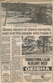
Newsclipping, Glossy record of shire's romantic past and the people who made it by Fab Calafuri, Diamond Valley News, 16 September 1986, 16 Sep 1986
... Road Montmorency Neil Douglas Panton Hill Peter Glass Research (Vic.) Sheila Ferguson shire of eltham Shire of Eltham Pioneers Photograph Collection St Andrews Yarra Glen Digital file only - Digitised by EDHS from a scrapbook on loan from Beryl Bradbury (nee Stokes), daughter of Frank Stokes. Glossy record of shire's romantic past and the people who made it by Fab Calafuri, Diamond Valley ...A review of Pioneers and PaintersDigital file only - Digitised by EDHS from a scrapbook on loan from Beryl Bradbury (nee Stokes), daughter of Frank Stokes.beryl bradbury (nee stokes) collection, pioneers and painters, alan marshall, centenary celebrations, christmas hills, clifton pugh, david newbury, dudley street, eltham, gareth jones roberts, hurstbridge, john perceval, joy peck, kangaroo ground, kinglake, lower plenty, luther haley general store, main road, montmorency, neil douglas, panton hill, peter glass, research (vic.), sheila ferguson, shire of eltham, shire of eltham pioneers photograph collection, st andrews, yarra glen -
 Eltham District Historical Society Inc
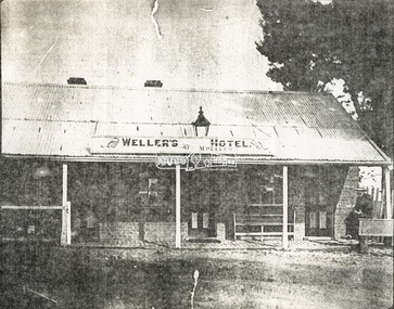
Document - Folder, Wellers of Kangaroo Ground, 1984-2017
... Retrieved from https://elthamhistory.files.wordpress.com/2017/10/edhs-nl-236-oct-2017.pdf • EDHS_03997 - Slide, Wellers Hotel, Pitmans Corner, Eltham-Yarra Glen Road, Kangaroo Ground, c.1975 https://victoriancollections.net.au/items/5e59e36221ea671798ac40eb • EDHS_03998 - Slide, Wellers Hotel, Pitmans Corner, Eltham-Yarra Glen Road, Kangaroo Ground, c.1975 https://victoriancollections.net.au/items/5e59e39e21ea671798ac9c27 • EDHS_03999 - Slide, Wellers Hotel, Pitmans Corner, Eltham-Yarra Glen Road, Kangaroo Ground, c.1975 https://victoriancollections.net.au/items/5e59e3c721ea671798acd2ef • EDHS_04000 - Slide, Wellers Hotel, Pitmans Corner, Eltham-Yarra Glen Road, Kangaroo Ground, c.1975 https://victoriancollections.net.au/items/5e59e3e021ea671798acfd68 • EDHS_04066-18 - Photograph, Wellers Restaurant, Eltham-Yarra Glen Road, Kangaroo Ground, c.Mar. 1989 https://victoriancollections.net.au/items/610f4dafa346aadcee7ac79c • EDHS_04041-26 - Photograph, Wellers Restaurant, 150 Eltham-Yarra Glen Road, Kangaroo Ground, c.May 1988 https://victoriancollections.net.au/items/610e2f4a7d65e7c945a35e69 • EDHS_04437 – Newsclipping, Renovated Weller's Pub to begin its new stage of life by Linley Hartley, Diamond Valley News, 26 January 1988 https://victoriancollections.net.au/items/5de4913921ea6710a46a85c7 • EDHS_04438 - Newsclipping, Wellers Restaurant by Lynne Hillier, Network, October 1988, p14 https://victoriancollections.net.au/items/5de4916f21ea6710a46aea0f • ArtStreams magazine (from Volume 9, 2004) ‘partnered' with Wellers in promoting and supporting the arts and culture. ...Retrieved from https://elthamhistory.files.wordpress.com/2017/10/edhs-nl-236-oct-2017.pdf • EDHS_03997 - Slide, Wellers Hotel, Pitmans Corner, Eltham-Yarra Glen Road, Kangaroo Ground, c.1975 https://victoriancollections.net.au/items/5e59e36221ea671798ac40eb • EDHS_03998 - Slide, Wellers Hotel, Pitmans Corner, Eltham-Yarra Glen Road, Kangaroo Ground, c.1975 https://victoriancollections.net.au/items/5e59e39e21ea671798ac9c27 • EDHS_03999 - Slide, Wellers Hotel, Pitmans Corner, Eltham-Yarra Glen Road, Kangaroo Ground, c.1975 https://victoriancollections.net.au/items/5e59e3c721ea671798acd2ef • EDHS_04000 - Slide, Wellers Hotel, Pitmans Corner, Eltham-Yarra Glen Road, Kangaroo Ground, c.1975 https://victoriancollections.net.au/items/5e59e3e021ea671798acfd68 • EDHS_04066-18 - Photograph, Wellers Restaurant, Eltham-Yarra Glen Road, Kangaroo Ground, c.Mar. 1989 https://victoriancollections.net.au/items/610f4dafa346aadcee7ac79c • EDHS_04041-26 - Photograph, Wellers Restaurant, 150 Eltham-Yarra Glen Road, Kangaroo Ground, c.May 1988 https://victoriancollections.net.au/items/610e2f4a7d65e7c945a35e69 • EDHS_04437 – Newsclipping, Renovated Weller's Pub to begin its new stage of life by Linley Hartley, Diamond Valley News, 26 January 1988 https://victoriancollections.net.au/items/5de4913921ea6710a46a85c7 • EDHS_04438 - Newsclipping, Wellers Restaurant by Lynne Hillier, Network, October 1988, p14 https://victoriancollections.net.au/items/5de4916f21ea6710a46aea0f • ArtStreams magazine (from Volume 9, 2004) ‘partnered' with Wellers in promoting and supporting the arts and culture. ...Wellers of Kangaroo Ground Vertical File Contents: 1. Article: History of Wellers Restaurant by Sandra Cahir, revised 2017. 7 pages 2. Article: Weller’s Hotel of Kangaroo Ground (final draft) by Jim Allan, 1 June 2017, including feedback email from Sandra Cahir (7 May 2017). 3. Printout of online image - Kangaroo Ground landholders from 1841, Kangaroo Ground Presbyterian Church. (2022, June 29). Retrieved from https://kgpc.pcvic.org.au/images/history_images/Kangaroo-Ground-landholders.jpg 4. Folder of printouts of historical newspaper articles referencing the hotel 1866-1911 https://trove.nla.gov.au/list/163201 5. Printouts (various versions) from Victorian Heritage Database (National Trust and Nillumbik Shire) https://vhd.heritagecouncil.vic.gov.au/ 6. Collection of research notes, copies of records from various publications including EDHS Chronology of Events and Kangaroo Ground: The Highland Taken by Mick Woiwod, pp90, 180-181 (EDHS_01618). 7. Report: Request for ministerial amendment to use the property as a restaurant, includes existing conditions and plan for development, 1 November 1984 8. Papers donated by Diana and Peter Bassett-Smith including: a. Photocopy of Weller’s Hotel, Licensee M. Weller b. Letter: Shire of Eltham to Office of the Secretary for Planning and Environment, 23 Feb 1984 - Information regarding inclusion of Wellers Hotel into the Historic Buildings Register c. Letter: Historic Buildings Council letter to Peter Bassett-Smith seeking historical information on Wellers Hotel, 10 Jan 1985 d. Memo: Peter Bassett-Smith to Robert N. Hendrey on history of Wellers Hotel, 28 Jan 1985 - Includes extract of information about Mary Weller, Dept. of Crown Lands and Survey Map NILLUMBIK showing properties of John Weller and E. Weller and a Diamond Valley News article from 10 April 1973, p11, "Eltham on old coach route" 9. Information about the Weller family including family trees from various sources a. Edward Weller, Pioneer Families in Victoria, http://mepnab.netau.net/w/w09.html, 1 Jan 2017 (link broken) b. The WELLER family tree. (2017, January 1), 2 pages. Retrieved from https://www.weller.org.uk/cgi-bin/FamilyTree/ShowFamily.pl? and 27 pages Retrieved from https://www.weller.org.uk/cgi-bin/FamilyTree/ShowFamily.pl?ListAllPeople=A c. Edward WELLER on the WELLER family tree. (2017, January 1), 1 page. Retrieved from https://www.weller.org.uk/cgi-bin/FamilyTree/ShowFamily.pl?PersonID=516 d. Photograph (print copy), believed to be Edward Weller, 1836-1883 e. Photograph (print copy), Gravestone of Weller family at Kangaroo Cemetery f. Wellers of Kangaroo Ground, 1 page, possibly from History, http://www.wellers.com.au (broken) c.2016 g. Edward and Mary Weller miscellaneous biographical research notes (by Jim Allen?) including from Ancestry.com, and extracts from Chappel file (EDHS_04448) with relevant names highlighted h. Information about the Vernon Pitman family from Ancestry.com 10. Newspaper articles: a. Cobb & Co called here by Marguerite Marshall; Diamond Valley News, May 4, 1982, p2 b. Rich is history, 30 August 1983 (very similar to previous article) c. Weller’s Pub - restaurant, craft store or art gallery? Diamond Valley News, October 22, 1985, p3 d. Despite years of neglect a magical charm lies waiting, Diamond Valley News, October 29, 1985 e. Old pub fate still in doubt, Diamond Valley News, (?) 29 October 1985 f. Renovated Weller’s Pub to begin its new stage of life, DVN 26 January 1988 g. Wellers Restaurant, Lynne Hillier, Network, October 1988, p14 h. Revolution at Wellers, Nillumbik Mail, December 20, 2000 i. Wellers brings on good times, Valley Weekly, June 22, 2005 j. Dine in with ideal outlook, Valley News, 10 August 2005 k. Advertisement: Wellers of Kangaroo Ground, Enjoy lunch, afternoon tea and dinner at Wellers from Tuesday to Sunday, Valley Weekly, Wednesday, August 31, 2005 l. Advertisement: Wellers of Kangaroo Ground, Appearing live; Normie Rowe Fri 24 Feb, Diamond Valley Leader February 22, 2006, p11 m. Advertisement: Wellers of Kangaroo Ground, Lunch Special, Diamond Valley Leader March 27, 2010 n. Braithwaite abounds to Kangaroo Ground, Gig Guide, The Age, Friday, October 8, 2010, p14 o. History up for grabs, Diamond Valley Leader, March 28, 2012 p. Advertisement: Wellers Restaurant, Freehold only for sale, Morrison Kleeman, Diamond Valley Leader, March 28, 2012 q. Restaurant’s crash course, Megan Bailey, Diamond Valley Leader, January 1, 2014, p3. Also accessible online - Staff praised after car crashes through Kangaroo Ground eatery. (2022, June 29). Retrieved from https://www.heraldsun.com.au/leader/north/staff-praised-after-car-crashes-through-kangaroo-ground-eatery/news-story/021c896a1ab6d76bd6b73f2e57dc1854 r. Eatery set for revival, Brittany Shanahan, Diamond Valley Leader 15 February 2017; Also, online as Much-loved Wellers of Kangaroo Ground to be relaunched as Italian restaurant Fondata 1872. (2022, June 29). Retrieved from https://www.heraldsun.com.au/leader/north/muchloved-wellers-in-kangaroo-ground-to-be-relaunched-as-italian-restaurant-fondata-1872/news-story/665777fb347584ef483867ae2b536a8f s. Fondata 1872 proves a big hit with food, Diamond Valley Leader 3 May 2017, p3 11. Wellers of Kangaroo Restaurant Bar Entertainment Functions, tri-fold brochure promotional brochure 12. Website Printout: Wellers Restaurant, Live Guide, (2017, January 5). Retrieved from http://www.liveguide.com.au/Restaurants_Bars/VIC/Kangaroo_Ground/Food_Styles/3... 13. Website Printout: Wellers of Kangaroo Ground, Only Melbourne (2017, January 30). Retrieved from http://www.onlymelbourne.com.au/wellers-of-kangaroo-ground 14. Printouts from Fondata 1872 website and Facebook page including colour photograph of sign in front and business card (2017). Related EDHS Collection items • Wellers Hotel of Kangaroo Ground by Jim Allen, Part 1, Newsletter No. 235, Eltham District Historical Society, August 2017. Retrieved from https://elthamhistory.files.wordpress.com/2017/08/edhs-nl-235-aug-2017.pdf • Wellers Hotel of Kangaroo Ground by Jim Allen, Part 2, Newsletter No. 236, Eltham District Historical Society, October 2017. Retrieved from https://elthamhistory.files.wordpress.com/2017/10/edhs-nl-236-oct-2017.pdf • EDHS_03997 - Slide, Wellers Hotel, Pitmans Corner, Eltham-Yarra Glen Road, Kangaroo Ground, c.1975 https://victoriancollections.net.au/items/5e59e36221ea671798ac40eb • EDHS_03998 - Slide, Wellers Hotel, Pitmans Corner, Eltham-Yarra Glen Road, Kangaroo Ground, c.1975 https://victoriancollections.net.au/items/5e59e39e21ea671798ac9c27 • EDHS_03999 - Slide, Wellers Hotel, Pitmans Corner, Eltham-Yarra Glen Road, Kangaroo Ground, c.1975 https://victoriancollections.net.au/items/5e59e3c721ea671798acd2ef • EDHS_04000 - Slide, Wellers Hotel, Pitmans Corner, Eltham-Yarra Glen Road, Kangaroo Ground, c.1975 https://victoriancollections.net.au/items/5e59e3e021ea671798acfd68 • EDHS_04066-18 - Photograph, Wellers Restaurant, Eltham-Yarra Glen Road, Kangaroo Ground, c.Mar. 1989 https://victoriancollections.net.au/items/610f4dafa346aadcee7ac79c • EDHS_04041-26 - Photograph, Wellers Restaurant, 150 Eltham-Yarra Glen Road, Kangaroo Ground, c.May 1988 https://victoriancollections.net.au/items/610e2f4a7d65e7c945a35e69 • EDHS_04437 – Newsclipping, Renovated Weller's Pub to begin its new stage of life by Linley Hartley, Diamond Valley News, 26 January 1988 https://victoriancollections.net.au/items/5de4913921ea6710a46a85c7 • EDHS_04438 - Newsclipping, Wellers Restaurant by Lynne Hillier, Network, October 1988, p14 https://victoriancollections.net.au/items/5de4916f21ea6710a46aea0f • ArtStreams magazine (from Volume 9, 2004) ‘partnered' with Wellers in promoting and supporting the arts and culture. Various advertisements throughout, particular with live performance acts. Numerous references throughout to art and music performances on site. • Stephen Cummings and Joe Camilleri at Wellers Kangaroo Ground, ArtStreams, Vol. 9, No. 4, Sep/Oct 2004, p17 EDHS_04406 - Journal, ArtStreams: Whittlesea, Banyule, Darebin, Manningham, Nillumbik, Yarra; Vol. 9, No. 4, Sep-Oct 2004 https://victoriancollections.net.au/items/5bcc086021ea6804a82a92a9 • Daryl Braithwaite rocks up at Wellers, Fiona Sievers, ArtStreams, Vol.10 No.2, 2005, pp6-7 EDHS_04409 - Journal, ArtStreams: Vol. 10, No. 2, 2005 https://victoriancollections.net.au/items/60f5416ab06f0c13a9419541 • Ephemeral Sculpture by Peter Dougherty, ArtStreams, Vol.10 No.3, 2005, pp7-9. About sculptures created in or on the grounds of culinary establishments throughout the Shire. - Denise Keele-Bedford constructed ‘Ou Well’ at Wellers Restaurant and Vicky Shukuroglou, also at Wellers set up cotton banners printed and painted with natural dyes from onion skins, spinach, radish beetroot, turmeric and charcoal. EDHS_04410 - Journal, ArtStreams: Vol. 10, No. 3, 2005 https://victoriancollections.net.au/items/60f5436db06f0c13a941ae19 • Music at Wellers Restaurant, ArtStreams, Vol.10 No.4, 2005, p23 EDHS_04411 - Journal, ArtStreams: Vol. 10, No. 4, 2005 https://victoriancollections.net.au/items/60f543e4b06f0c13a941b059 • Weller’s Pub, Diamond Valley sketchbook / text by Brian McKinlay ; drawings by Graham Hawley, 1973, pp42-43 EDHS_00856 - https://victoriancollections.net.au/items/590852edd0ce7b14e8177da3 • Gold Field Coaches Stopped Here, Nillumbik now and then / Marguerite Marshall; photographs Alan King with Marguerite Marshall, 2008, pp86-87 EDHS_00977 - https://victoriancollections.net.au/items/5935f315d0cdd42c80f9cc52 External Links: • Historic Kangaroo Ground venue comes up for rare sale. (2022, June 29). Retrieved from https://www.smh.com.au/business/companies/historic-kangaroo-ground-venue-comes-up-for-rare-sale-20120325-1vshw.html • Wellers, Kangaroo Ground property sold with leaseback. (2022, June 29). Retrieved from https://www.urban.com.au/expert-insights/investing/37735-wellers-kangaroo-ground-property-sold-with-leaseback • Wellers, Kangaroo Ground | With Mark Seymour, at one of his …. (2022, June 29). Retrieved from https://www.flickr.com/photos/robertmilesdesign/4564390893/ • 2016 Notice of proposed deregistration - WELLERS OF KANGAROO GROUND PTY LTD 124 435 409. (2022, June 29). Retrieved from https://publishednotices.asic.gov.au/browsesearch-notices/notice-details/WELLERS-OF-KANGAROO-GROUND-PTY-LTD-124435409/35d43b89-159a-4435-963f-daec688a61ca • Search results for: Websites (archived). (2022, June 29). Retrieved from https://trove.nla.gov.au/search/category/websites?keyword=%22wellers%20restaurant%22 29 June 2022 edward weller, wellers of kangaroo ground, wellers hotel, wellers restaurant, mary weller, pittmans corner, fondata 1812 at wellers, historic buildings register, hotels, john weller, kangaroo ground, pitman's corner, bassett-smith collection -
 Eltham District Historical Society Inc
Photograph, Edendale Farm, Eltham Heritage Tour, 24 May 1992
... The drive took us past the Dutch Windmill, only twenty years old and in the Shire of Diamond Valley, then the Diamond Creek Cemetery with impressive gateway, to a detour to see another old farmhouse, isolated on a hill off Murray Road Wattle Glen. ...The drive took us past the Dutch Windmill, only twenty years old and in the Shire of Diamond Valley, then the Diamond Creek Cemetery with impressive gateway, to a detour to see another old farmhouse, isolated on a hill off Murray Road Wattle Glen. ...ELTHAM HERITAGE TOUR The Society excursion on 24th May 1992 was arranged by David Bick, leader of the team carrying out the Shire's heritage study. David selected a number of sites or buildings identified in the study, some of them lesser known components of the Shire's heritage. The tour commenced at the Eltham Shire Office at 10.00 am. Travel was by private car and mini-bus with stops at about twelve locations for commentary by David.It included a short walk in Hurstbridge and lunch at Kinglake. Highlights of the tour included: - 10 am Leave from Shire Offices - 3 Important Trees - A Physical Link to Eltham's First Settlers - Toorak Mansion Gates - A Surviving Farm House - An Intact Circa 1900 Main Street - First Settlers - Gold Miners, and Timber-getters - An Early Hotel - A Pioneering Homestead - Changing Eltham Shire - 20th Century - 4 pm Afternoon Tea and Finish Tour Extract from ELTHAM CULTURAL HERITAGE TOUR (Newsletter No. 85, July 1992, by Bettina Woodburn) "The land was unprofitable for intensive farming, but there was always water in the Diamond Creek. The railway, a technological advance, followed the valley, and was provided to transport produce. At North Eltham we were privileged to tour a surviving farmhouse of the 1860-70 era at the Shire’s Edendale Farm, with the as yet unfinished Sculpture for a front fence - bulbous tree-trunks decorated with salt pots, with cross members from the old trestle bridge. As was usual these six veranda posted houses faced South (or East, away from the sun!) with the scullery, kitchen and pantry "out the back". The veranda, which must have been very narrow, no longer exists. It probably wrapped around three sides. The drive took us past the Dutch Windmill, only twenty years old and in the Shire of Diamond Valley, then the Diamond Creek Cemetery with impressive gateway, to a detour to see another old farmhouse, isolated on a hill off Murray Road Wattle Glen. Here was a particularly thick patch of exotic planting of pines and cypresses. Subsistence farming no longer pays. Following the rail-line we noticed on the left near Silvan Road an Edwardian cottage and on the right near Yates Road the old school residence for this Upper Diamond Creek area."Record of the Society's history and activities and highlighting various aspects of the Heritage Study undertaken by David Bick used to create the future heritage overlay for the Shire of Eltham and later Nillumbik Shire.Roll of 35mm colour negative film, 4 strips Associated colour printKodak Gold 100 5095eltham, shire of eltham historical society, activities, heritage tour, 1992, culture, edendale, edendale community farm, events -
 Eltham District Historical Society Inc
Photograph, Edendale Farm, Eltham Heritage Tour, 24 May 1992
... The drive took us past the Dutch Windmill, only twenty years old and in the Shire of Diamond Valley, then the Diamond Creek Cemetery with impressive gateway, to a detour to see another old farmhouse, isolated on a hill off Murray Road Wattle Glen. ...The drive took us past the Dutch Windmill, only twenty years old and in the Shire of Diamond Valley, then the Diamond Creek Cemetery with impressive gateway, to a detour to see another old farmhouse, isolated on a hill off Murray Road Wattle Glen. ...ELTHAM HERITAGE TOUR The Society excursion on 24th May 1992 was arranged by David Bick, leader of the team carrying out the Shire's heritage study. David selected a number of sites or buildings identified in the study, some of them lesser known components of the Shire's heritage. The tour commenced at the Eltham Shire Office at 10.00 am. Travel was by private car and mini-bus with stops at about twelve locations for commentary by David.It included a short walk in Hurstbridge and lunch at Kinglake. Highlights of the tour included: - 10 am Leave from Shire Offices - 3 Important Trees - A Physical Link to Eltham's First Settlers - Toorak Mansion Gates - A Surviving Farm House - An Intact Circa 1900 Main Street - First Settlers - Gold Miners, and Timber-getters - An Early Hotel - A Pioneering Homestead - Changing Eltham Shire - 20th Century - 4 pm Afternoon Tea and Finish Tour Extract from ELTHAM CULTURAL HERITAGE TOUR (Newsletter No. 85, July 1992, by Bettina Woodburn) "The land was unprofitable for intensive farming, but there was always water in the Diamond Creek. The railway, a technological advance, followed the valley, and was provided to transport produce. At North Eltham we were privileged to tour a surviving farmhouse of the 1860-70 era at the Shire’s Edendale Farm, with the as yet unfinished Sculpture for a front fence - bulbous tree-trunks decorated with salt pots, with cross members from the old trestle bridge. As was usual these six veranda posted houses faced South (or East, away from the sun!) with the scullery, kitchen and pantry "out the back". The veranda, which must have been very narrow, no longer exists. It probably wrapped around three sides. The drive took us past the Dutch Windmill, only twenty years old and in the Shire of Diamond Valley, then the Diamond Creek Cemetery with impressive gateway, to a detour to see another old farmhouse, isolated on a hill off Murray Road Wattle Glen. Here was a particularly thick patch of exotic planting of pines and cypresses. Subsistence farming no longer pays. Following the rail-line we noticed on the left near Silvan Road an Edwardian cottage and on the right near Yates Road the old school residence for this Upper Diamond Creek area."Record of the Society's history and activities and highlighting various aspects of the Heritage Study undertaken by David Bick used to create the future heritage overlay for the Shire of Eltham and later Nillumbik Shire.Roll of 35mm colour negative film, 4 strips Colour printKodak Gold 100 5095eltham, shire of eltham historical society, activities, heritage tour, 1992, culture, edendale, edendale community farm, events -
 Eltham District Historical Society Inc
Photograph, Edendale Farm, Eltham Heritage Tour, 24 May 1992, 24/05/1992
... The drive took us past the Dutch Windmill, only twenty years old and in the Shire of Diamond Valley, then the Diamond Creek Cemetery with impressive gateway, to a detour to see another old farmhouse, isolated on a hill off Murray Road Wattle Glen. ...The drive took us past the Dutch Windmill, only twenty years old and in the Shire of Diamond Valley, then the Diamond Creek Cemetery with impressive gateway, to a detour to see another old farmhouse, isolated on a hill off Murray Road Wattle Glen. ...ELTHAM HERITAGE TOUR The Society excursion on 24th May 1992 was arranged by David Bick, leader of the team carrying out the Shire's heritage study. David selected a number of sites or buildings identified in the study, some of them lesser known components of the Shire's heritage. The tour commenced at the Eltham Shire Office at 10.00 am. Travel was by private car and mini-bus with stops at about twelve locations for commentary by David.It included a short walk in Hurstbridge and lunch at Kinglake. Highlights of the tour included: - 10 am Leave from Shire Offices - 3 Important Trees - A Physical Link to Eltham's First Settlers - Toorak Mansion Gates - A Surviving Farm House - An Intact Circa 1900 Main Street - First Settlers - Gold Miners, and Timber-getters - An Early Hotel - A Pioneering Homestead - Changing Eltham Shire - 20th Century - 4 pm Afternoon Tea and Finish Tour Extract from ELTHAM CULTURAL HERITAGE TOUR (Newsletter No. 85, July 1992, by Bettina Woodburn) "The land was unprofitable for intensive farming, but there was always water in the Diamond Creek. The railway, a technological advance, followed the valley, and was provided to transport produce. At North Eltham we were privileged to tour a surviving farmhouse of the 1860-70 era at the Shire’s Edendale Farm, with the as yet unfinished Sculpture for a front fence - bulbous tree-trunks decorated with salt pots, with cross members from the old trestle bridge. As was usual these six veranda posted houses faced South (or East, away from the sun!) with the scullery, kitchen and pantry "out the back". The veranda, which must have been very narrow, no longer exists. It probably wrapped around three sides. The drive took us past the Dutch Windmill, only twenty years old and in the Shire of Diamond Valley, then the Diamond Creek Cemetery with impressive gateway, to a detour to see another old farmhouse, isolated on a hill off Murray Road Wattle Glen. Here was a particularly thick patch of exotic planting of pines and cypresses. Subsistence farming no longer pays. Following the rail-line we noticed on the left near Silvan Road an Edwardian cottage and on the right near Yates Road the old school residence for this Upper Diamond Creek area."Record of the Society's history and activities and highlighting various aspects of the Heritage Study undertaken by David Bick used to create the future heritage overlay for the Shire of Eltham and later Nillumbik Shire.Roll of 35mm colour negative film, 4 stripsKodak Gold 100 5095eltham, shire of eltham historical society, activities, heritage tour -
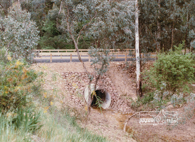 Eltham District Historical Society Inc
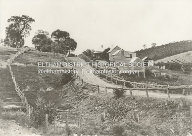
Photograph, Valley Road Culvert, Wattle Glen, c. Oct 1987, 1987
... Valley Road Culvert, Wattle Glen, c. Oct 1987...Valley Road...Culvert...Wattle Glen...Eltham District Historical Society Inc 728 Main Rd Eltham melbourne Date based on other similar display panels visible in images of the Shire of Eltham display at the Eltham Community Festival, 7 November 1987. display panel eltham festival infrastructure shire of eltham Valley Road Culvert Wattle Glen Colour photograph Valley Road Culvert, Wattle Glen, c. ...Date based on other similar display panels visible in images of the Shire of Eltham display at the Eltham Community Festival, 7 November 1987.Colour photographdisplay panel, eltham festival, infrastructure, shire of eltham, valley road, culvert, wattle glen