
Showing 6 items matching "glenauburn road"
-
 Eltham District Historical Society Inc
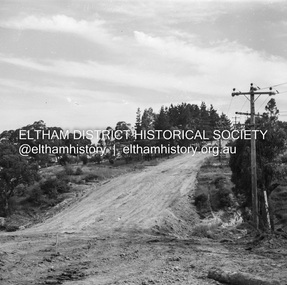
Negative - Photograph, J.A. McDonald, Para Road, Dec. 1960
... ...Glenauburn Road...Realignment Para Road December 1960 Taken from opposite Glenauburn Road...Realignment Para Road December 1960 Taken from opposite Glenauburn Road Record of various Shire of Eltham infrastructure works undertaken during the period of 1952-1962 involving bridge and road reconstruction projects, sometimes with Eltham Shire Council Project Reference numbers quoted. ...Realignment Para Road December 1960 Taken from opposite Glenauburn RoadRecord of various Shire of Eltham infrastructure works undertaken during the period of 1952-1962 involving bridge and road reconstruction projects, sometimes with Eltham Shire Council Project Reference numbers quoted. It was during this period that a number of significant improvements were made to roads and new bridges constructed within the shire that remain in place as of present day (2022). In many situations, the photos provide a tangible visible record of infrastructure that existed throughout the early days of the Shire. The album was put together by or under the direction of the Shire Engineer, J.A. McDonald.infrastructure, shire of eltham, road construction, 1960-12, glenauburn road, para road -
 Greensborough Historical Society
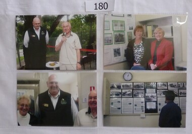
Photograph, Greensborough Historical Society, Greensborough Historical Society - opening of Resource Centre 22 October 2011, 22/10/2011
... Taken at the opening of the Resource Centre in Glenauburn Road....Taken at the opening of the Resource Centre in Glenauburn Road. Greensborough Historical Society - opening of Resource Centre 22 October 2011 Photograph Photograph Greensborough Historical Society ...Photographs taken at the opening of the Resource Centre 22 October 2011. Subjects include GHS President Noel Withers, Mayor of Banyule Peter McKenna and members Faye Fort, Helen Bryant, Marilyn Smith and Frank Evans.Official opening of Greensborough Historical Society's Resource Centre4 x photographs, colour. Taken at the opening of the Resource Centre in Glenauburn Road.greensborough historical society, resource centre, noel withers, peter mckenna -
 Eltham District Historical Society Inc
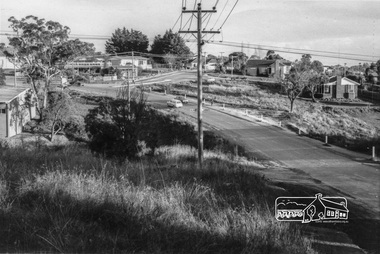
Photograph, Looking south along Para Road at intersection of Alma Street and Lees Road, Lower Plenty, c.July 1967, 1967
... ...glenauburn road...Old community hall (long wall with row of windows) and Lower Plenty Kindergarten visible at corner of Glenauburn and Para Roads. Packaged in "Filmpro King Size prints Definitely Better EST. 1918" envelope. ...Old community hall (long wall with row of windows) and Lower Plenty Kindergarten visible at corner of Glenauburn and Para Roads. Packaged in "Filmpro King Size prints Definitely Better EST. 1918" envelope. ...Old community hall (long wall with row of windows) and Lower Plenty Kindergarten visible at corner of Glenauburn and Para Roads. Packaged in "Filmpro King Size prints Definitely Better EST. 1918" envelope. Pencil notes: 36 shots $2.87 Eltham Shire J. McD and 19/7/67. Alma Street and Kett Street Lower Plenty c.July 1967.Black and white photographalma street, glenauburn road, carisbrook crescent, lees road, lower plenty, lower plenty kindergarten, para road, houses, streets -
 Eltham District Historical Society Inc
Album - Photograph Album, J.A. McDonald, Bridge and Road Reconstruction Works, Shire of Eltham, 1952-1962
... ...Glenauburn Road...Blair Garden Hill Glen Park Bridge Glenauburn Road Grand Hotel Haldane Road Healesville Healesville-Yarra Glen Road Heidelberg-Kinglake Road Henley Road Bridge Henley Road Hill property Hurstbridge Water scheme Hurstbridge Hurstbridge-Arthurs Creek Road Infrastructure J. ...J.A. McDonald produced this record in the course of his responsibilities as Shire Engineer for Eltham Shire Council.Record of various Shire of Eltham infrastructure works undertaken during the period of 1952-1962 involving bridge and road reconstruction projects, sometimes with Eltham Shire Council Project Reference numbers quoted. It was during this period that a number of significant improvements were made to roads and new bridges constructed within the shire that remain in place as of present day (2022). In many situations, the photos provide a tangible visible record of infrastructure that existed throughout the early days of the Shire. The album was put together by or under the direction of the Shire Engineer, J.A. McDonald.a. gillies, alistair knox park, benchmark studies, bend of islands, blease road, box hill state school, box hill teachers college, box hill tip, bridge construction, bridge street bridge, bridge, brisbane street, brougham steet, bulldozer, cecil street, charis pelling, cherry tree road, city of preston, cr. a. brinkkotter, cr. charis pelling, cranes, cromwell street, diamond creek (creek), diamond street, dixons creek bridge, dixon's creek road, drott, eltham leisure centre, eltham north, eltham police station, eltham, eltham-yarra glen road, f. wood, fitzsimons lane bridge, flat rock road, flood damage, floods, floodwater, footpaths and gutters, ford service garage, g. blair, garden hill, glen park bridge, glenauburn road, grand hotel, haldane road, healesville, healesville-yarra glen road, heidelberg-kinglake road, henley road bridge, henley road, hill property, hurstbridge water scheme, hurstbridge, hurstbridge-arthurs creek road, infrastructure, j. jolly, kangaroo ground, kangaroo ground-queenstown road, kangaroo ground-st andrews road, lilydale shire office, long gully bridge, long gully creek, long gully road, long gully, lower plenty bridge, lower plenty footbridge, lower plenty oval, lower plenty road, lower plenty, main road, methodist church, montmorency, mount pleasant road, new holland, old healesville road, opening ceremony, oxley bridge, para road, paul creek bridge, paul creek road, paul krafeznk, pinnacle lane, plaques, plenty river trail, plenty river, presbyterian church, prof donald thomson, pryor street, railway crossing, railway parade, rattray road, reconstruction works, reichelt avenue, research (vic.), research oval, road construction, rymers corner, shire of eltham, shire of whittlesea, silvan road bridge, silver street bridge, silver street, sir dallas brooks, smedley property, st andrews, steels creek, susan street, tarrawarra, tony carberry, uniting church, upper yarra dam, upper yarra reservoir, w.e. wolf, waterfall property, watsons creek, wattletree road bridge, wattletree road, wattletree road bridge, worlingworth, yarra glen, york street, yow yow creek -
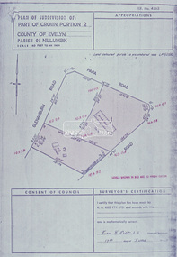 Eltham District Historical Society Inc
Slide - Photograph, Eltham Shire Council, Plan of Subdivision of Part of Crown Portion 2, Parish of Nillumbik, County of Evelyn, 1969
... ...Glenauburn Road...Infrastructure Map planning Subdivison Lots Glenauburn Road Para Road C2, Grant of subdivision, Para and Glenauburn, 4 August 1969 35mm colour positive transparency blue Agfacolour Service plastic mount Plan of Subdivision of Part of Crown Portion 2, Parish of Nillumbik, County of Evelyn Slide Photograph Eltham Shire Council ...35mm colour positive transparency blue Agfacolour Service plastic mountC2, Grant of subdivision, Para and Glenauburn, 4 August 1969infrastructure, map, planning, subdivison lots, glenauburn road, para road -
![Article - Newspaper Clipping - Digital Image, Objections to street scheme withdrawn [Calrossie Avenue Montmorency], 05/11/1965](/media/collectors/4f729f5697f83e03086015b8/items/5eb3892321ea670b94d36b17/item-media/5eb389de21ea670b94d4605a/item-fit-380x285.jpg?cb=6) Greensborough Historical Society
Greensborough Historical SocietyArticle - Newspaper Clipping - Digital Image, Objections to street scheme withdrawn [Calrossie Avenue Montmorency], 05/11/1965
... st faiths road montmorency...glenauburn...An example of concerns over road construction in the formerly 'bush' areas of Diamond Valley montmorency streets calrossie avenue montmorency meadow crescent montmorency lilicur road montmorency woodland grove montmorency st faiths road montmorency glenauburn estate montmorency shire of diamond valley street construction News clipping, black and white text Objections to street scheme withdrawn [Calrossie Avenue Montmorency] Article Newspaper Clipping - Digital Image Diamond Valley Leader Diamond Valley Leader Caroline Gonzalez ...In 1965, tenders were called for the construction of streets in Montmorency after objections were withdrawn.An example of concerns over road construction in the formerly 'bush' areas of Diamond ValleyNews clipping, black and white textmontmorency streets, calrossie avenue montmorency, meadow crescent montmorency, lilicur road montmorency, woodland grove montmorency, st faiths road montmorency, glenauburn estate montmorency, shire of diamond valley, street construction
