Showing 4 items matching "glenlyon road"
-
 Brunswick Community History Group
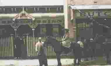
Photograph - Butcher's shop, Glenlyon Road, 1903
... Butcher's shop, Glenlyon Road......Glenlyon Road...Butcher's shop, Glenlyon Road. The donor states that the shop was located at #41 and the house was called Glen Wallace and probably owned by the Prowse family. ...Butcher's shop Glenlyon Road Butcher's shop, Glenlyon Road. The donor states that the shop was located at #41 and the house was called Glen Wallace and probably owned by the Prowse family. ...Butcher's shop, Glenlyon Road. The donor states that the shop was located at #41 and the house was called Glen Wallace and probably owned by the Prowse family. Featured in Fusion, vol 26, issue 4, November 2012.butcher's shop, glenlyon road -
 Melbourne Tram Museum
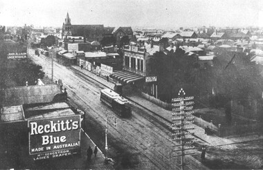
Photograph - Cable Tram on Sydney Road/Glenlyon Road, c. 1919, C. 1919
... Cable Tram on Sydney Road/Glenlyon Road, c. 1919...Photograph Cable Tram on Sydney Road/Glenlyon Road, c. 1919 ...This photograph depicts a cable tram on Sydney Road past Brunswick Town Hall.Shows a cable tram line in Brunswick that has since been electrified.Black and white photograph with caption.“Sydney Road looking north from the Town Hall (19/07)” printed in front.cable trams, sydney road, brunswick -
 Ringwood RSL Sub-Branch
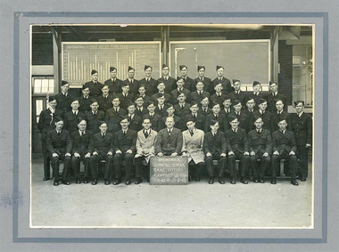
Album - RAAF, Brunswick Technical School RAAF Fitters Course 1942, August 1942
... Glenlyon Road, Brunswick, Victoria , Australia ...Black and White photo on card backing, Fitters Course, Flights 7 - 8 - 11, 3rd August 1942 - 25th September 1942Signed by members who attended the course on the reverse. -
 Ballan Shire Historical Society
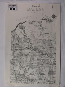
Map - Map. Shire of Ballan, Shire of Ballan
... Ballan Shire Historical Society 45-47 Steiglitz St Ballan goldfields This is a fairly comprehensive map of the former Shire of Ballan which is now amalgamated into the Shire of Moorabool. gordon ballan bungal kerrit bareet borhoneyghurk bungeeltap ballark yaloak gorong beremboke wallace ingliston hunterston millbrook bradshaw myrniong blackwood moorarbool greendale bayup trentham bullarto korweinguboora glenlyon bolwarra A black and white map of the Shire of Ballan showing major roads, rivers, towns, settlements, State parks and forests and land subdivisions. ...This is a fairly comprehensive map of the former Shire of Ballan which is now amalgamated into the Shire of Moorabool.A black and white map of the Shire of Ballan showing major roads, rivers, towns, settlements, State parks and forests and land subdivisions. It appears to be a copy of the original as no dates or maker or printer appear on the map. There is a scale of 2 miles to 1 inch.gordon, ballan, bungal, kerrit bareet, borhoneyghurk, bungeeltap, ballark, yaloak, gorong, beremboke, wallace, ingliston, hunterston, millbrook, bradshaw, myrniong, blackwood, moorarbool, greendale, bayup, trentham, bullarto, korweinguboora, glenlyon, bolwarra