Showing 2 items matching "glenmore victoria maps"
-
 Bacchus Marsh & District Historical Society
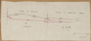
Map, Road plan deviation near Glenmore
... ...Glenmore Victoria Maps...Road Plans Road Construction Glenmore Victoria Maps Old road colored Yellow, New road colored Pink A single page paper map showing a plan for a road deviation near Glenmore Station. ...This plan shows a proposed deviation in the road near Glenmore. This is likely to have been the Bacchus Marsh to Ballan road. The precise date of the plan has not been established. Proposed deviations to the road near Glenmore appear in reports in the Bacchus Marsh Express newspaper through many decades, especially in the 1870s and 1880s. Glenmore is located 19 kilometers west of Bacchus Marsh.A single page paper map showing a plan for a road deviation near Glenmore Station. Scale 5 chains to 1 inch. Date of production unknown. Circa 1860s-1890s. The map is pasted into a bound volume containing 76 maps or plans in total. High resolution digital image stored on BMDHS computer network. Old road colored Yellow, New road colored Pinkroad plans, road construction, glenmore victoria maps -
 Bacchus Marsh & District Historical Society
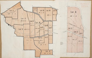
Map, Glenvale Estate and Glenmore Estate Land Sales 1909
... These two plans document another major sale of the land from the original Glenmore Estate including part of the estate which had become used for dairy farming and was at that time known as the Glenvale Estate. Bacchus Marsh Victoria Maps ...The two land auction plans shown in this record relate to the sale of land from the Glenmore Estate property. The Glenmore property was established by C.J. (Charles James) Griffith and James Moore around 1840. Moore sold his interest to Moelesworth Greene in 1848. Greene was the nephew of the other owner Charles Griffith who died in 1863. From around the 1870s onwards parts of the Estate were subdivided and put up for sale or lease. In subsequent decades more changes in ownership occurred. These two plans document another major sale of the land from the original Glenmore Estate including part of the estate which had become used for dairy farming and was at that time known as the Glenvale Estate. Two single page maps pasted together on a single page of a bound volume of maps. One map shows 15 separate lots of land for sale. The other map which has the words 'Glenvale Estate' at the top of the map shows 4 lots of land for sale. Both parcels of land were originally part of the Glenmore Estate a pastoral holding belonging to C.J. Griffith and James Moore which the began in the Rowsley area south west of Bacchus Marsh in the 1840s. The maps are pasted into a bound volume containing 76 maps or plans in total. High resolution digital image stored on BMDHS computer network. bacchus marsh victoria maps, glenvale estate property, glenvale estate land sales, glenmore estate, glenmore station