Showing 121 items matching glenvale
-
 Ringwood and District Historical Society
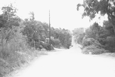
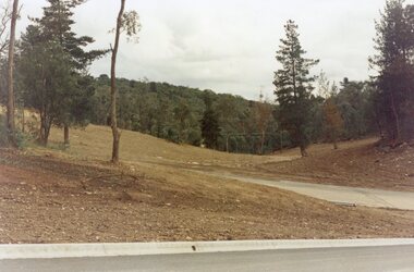
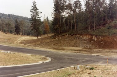
Photograph, Glenvale Road, North Ringwood - a boundary looking south. 1979
[Kubis Dve or Kubba Rd?.]Written on back of photograph, "Jan. 79. Glenvale Road - a boundary looking south from top of same hill (near Kubla Rd?).More homes south than north." -
 Ringwood and District Historical Society
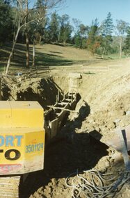
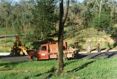
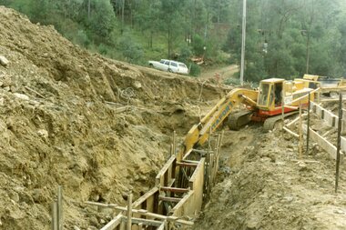
Photograph, The Kato working on the pumping plant at the end of the sewer trench near Glenvale Road, North Ringwood, on 10 June 1978. Loughnan's Lake site shown as a grassy hollow in the background
E550 N2 & N3 Part of a 51-photo record of the development of the "Kubis" Estate, Ringwood North, including road works to Debbie Place, Kubis Drive, Werac Drive, Manuelo Drive, Iluka Place and Glenvale Road. From the Jack Lundy Clarke collection.51 -
 Ringwood and District Historical Society
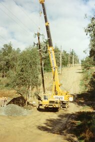
Photograph, SEC poles going up in Glenvale Road, North Ringwood, on 14 May April 1998
E548 N37, N39 & N41 Part of a 51-photo record of the development of the "Kubis" Estate, Ringwood North, including road works to Debbie Place, Kubis Drive, Werac Drive, Manuelo Drive, Iluka Place and Glenvale Road. From the Jack Lundy Clarke collection.51 -
 Ringwood and District Historical Society
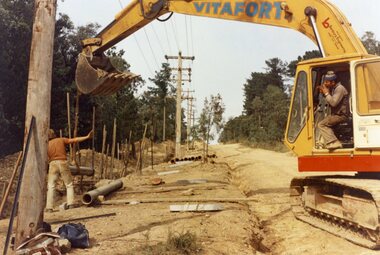
Photograph, The Kato working in Glenvale Road, North Ringwood, in April 1978. Laying pipes from the MMBW
E548 N37, N39 & N41 Part of a 51-photo record of the development of the "Kubis" Estate, Ringwood North, including road works to Debbie Place, Kubis Drive, Werac Drive, Manuelo Drive, Iluka Place and Glenvale Road. From the Jack Lundy Clarke collection.51 -
 Ringwood and District Historical Society
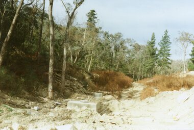
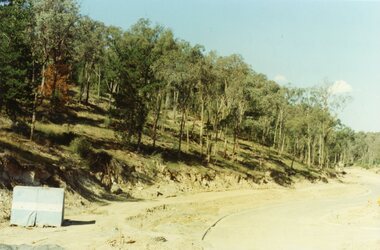
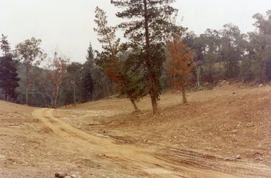
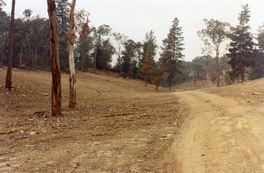
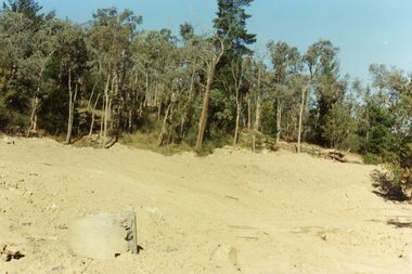
Photograph, View up the gully from Glenvale Road, North Ringwood towards the spot of the wall of Loughnan's Lake was
The brown undergrowth is on the remains of the walls, since levelled. Circa 1979. Part of a 51-photo record of the development of the "Kubis" Estate, Ringwood North, including road works to Debbie Place, Kubis Drive, Werac Drive, Manuelo Drive, Iluka Place and Glenvale Road. From the Jack Lundy Clarke collection. -
 Eltham District Historical Society Inc
Book, Glenvale School (Lilydale, Vic.). Committee of Parents and Friends, Firestorm : Black Saturday's Tragedy, 2009
This book is dedicated to all who lost so much on the darkest Saturday in Australia's history. Australia's worst natural disaster was a tragedy beyond belief that scarred Victoria physically and the whole Australian nation physiologically. Extreme temperatures, tornado-like wind speeds and tinder-dry land, culminated in the disaster we now know as Black Saturday. Before the sun would set on the blackest day in Australia's history, thousands of hectares would become blackened landscape and an unparalleled loss of lives could only mean that many areas would never be the same again. This graphic pictorial record takes you through the conditions prior to the day, the horrific fires that destroyed both bush and townships alike, the amazing bravery of emergency services personnel and the tragic aftermath. Accounts from eye-witnesses describe a fire like never seen before, a wild fire that outran every warning system. "A comprehensive account of Australia's worst natural disaster ever"black saturday, bush fires, bushfire, fire damage - buildings, victorian bushfires - 2009 -
 Whitehorse Historical Society Inc.
Map, Deep Creek Road, Mitcham, c1975
Enlargement of aerial photograph of area bounded by Dalmar Road, Cray Road, Glenvale Road and Maroondah Highway, MitchamEnlargement of aerial photograph of area bounded by Dalmar Road, Cray Road, Glenvale Road and Maroondah Highway, MitchamEnlargement of aerial photograph of area bounded by Dalmar Road, Cray Road, Glenvale Road and Maroondah Highway, Mitchamcray road, donvale, glenvale road, donvale, maroondah highway, mitcham, dalmor road, mitcham, deep creek road, mitcham, aerial photographs -
Ringwood and District Historical Society
Leaflet, Chris A. Moule, Auctioneer, Pamphlet produced for a builders realisation sale of lets in Manuela Terrace and Lyn Court Ringwood 1979, 1979
Pamphlet produced for a builders realisation sale of lets in Manuela Terrace and Lyn Court Ringwood 6th December 1979 in the "Bel-Air" Estate marked between Glenvale Road and Oban Road on diagrammatic map of Ringwood.Single page double-sided leaflet, black printing, front has red border. +Additional Keywords: Moule, C.A. -
 Whittlesea Historical Society Inc.
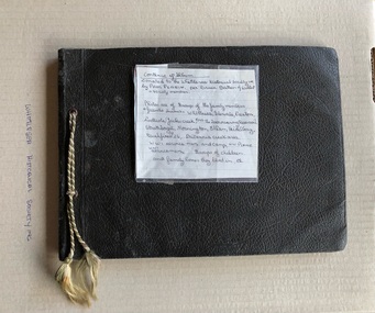
Album - Photograph, Brown Album, c.1925
Album of personal photographs of family members, friends, groups of children, and areas of Whittlesea, Glenvale, Preston, Northcote, Jack's Creek, Strathbogie, Mornington, Eltham, Heidelberg, Britannia Creek, WW1 service men and camp and a defence plane. Page 1 1. Remains of School after fire Britannia Creek 1926 2. Result of Bushfire Britannia Creek Creek 1926 3. Fish pond destroyed by fire 1926 4. Children Britannia Creek 1926 Page 2 1. Three men and a boy after the bushfire Britannia Creek 1926 2. Men and a car, Mentone, J. Gollary, Tom O' Connor 3. Dog and a kennel, "Brownie", Preston 1925 4. Group of children, "An apple a day", Britannia Creek 1926 Page 3 1. Whittlesea Show 2. Three women, Strathbogie 3. Timber track Britannia 4. Two girls sitting, "In the right mood" 5. 9th Patrol Preston ? Bruthen Page 4 1. The moon 2. House and fence, St George's Road, Northcote 3. Biplane, A Defence Plane 4. Close up, plane landed, service men looking at plane, "A close up view" Page 5 Top of page, "Dranold" Hawking St, Preston 1. House with fence, "House" 2. Garden right side 3. Garden left side 4. Man in garden holding a watering can, "Back garden" Page 6 Four photos of Kinglake 1. Fern Gully Plenty Ranges 2. Plenty Ranges 3. Mt Disappoinment 4. Road through water shed Page 7 1. View of Whittlesea Township 2. Eel pond, Glenvale 3. Haymaking, "Stacking", Glenvale 4. Harvesting Glenvale Page 8 Four photos of creeks 1. Jack's Creek 2. Jack's Creek and shed (this looks like the Toorourrong Reservoir 3. A barrel in the water, "Bruce's Creek" 4. Water running over rocks, "Bruce's Creek" Page 9 1. Horse and rider with 2 men, Whittlesea 2. View from Mt Hope looking South Glenvale 3. Cricket Ground Heidelberg 4. View of a cliff, bottle necked swallow's nests Page 10 "Eltham Cup Day" at top of page 1. Norm and Syd - men playing cricket 2. Ralph - playing cricket 3. Norm and Syd - playing cricket Page 11 1. 8 boys - Preston B Baseball Team 2. Group of men - Eltham 3. Woman standing - V. Townsend 4. Horse and Wagon - WW1 Williamstown Camp, C. Jose Page 12 1. Man sitting on bricks - Stan 2. School boy - He? F Greenough 3. Boy posing with baseball bat 4. Ted Cecil Page 13 1. 2 woman, 2 men standing in bush setting - "The Grants" 2. Woman standing on a hill overlooking a township below 3. View of water - "Mornington" 4. A house - "Mornington" Page 14 Strathbogie 1. Man standing outside a wooden building 2. Man standing outside a wooden building having a wash 3. Girl and boy 4. 3 children standing next to a wooden house Brown coloured, detachable leaf paste-in photo book, 7 loose pages, cord threaded through eyelets on the left side. Photographs pasted on to both sides of pages. Total of 56 photos, black and white. Descriptions handwritten above or below each photo. Some of the photos dated 1925 and 1926. Inscribed on the front of the album, "The Warwick Album"whittlesea, britannia creek, glenvale, jack's creek, strathbogie, ww1, service men, j gollary, tom o'connor, dog and kennel, 1853, whittlesea show, 9th patrol preston, defence plane, st george's road, northcote, preston, dranold hawking steet preston, kinglake, mount disappointment, plenty ranges, fern gully plenty ranges, haymaking, gkenvale, harvesting glenvale, whittlesea township, toorourrong reservoir, bruce's creek, mt hope, cricket ground heidelberg, horse, eltham cup day, cricket, norm and syd, preston b baseball team, v townsend, horse and wagon, ww1 williamstown camp, c jose, ted cecil, stan, mornington, the grants -
 Whitehorse Historical Society Inc.
Photograph, Deep Creek Road, Mitcham, 1/01/2001
Black and white photograph of Deep Creek Road, taken from lower entrance of Schwerkolt Cottage Reserve showing Glenvale Road on left. Taken before work started on new bridge and road.deep creek road, mitcham, glenvale road, ringwood -
 Whitehorse Historical Society Inc.
Photograph, Deep Creek Road, Mitcham, 1/01/2001 12:00:00 AM
Black and white photograph of Deep Creek Road, Mitcham taken from lower entrance of Schwerkolt Cottage Reserve showing Glenvale Road on left. Photo taken before work started on new road and bridge.deep creek road, mitcham, glenvale road, ringwood -
 Ringwood and District Historical Society
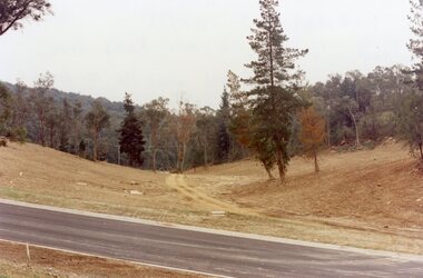
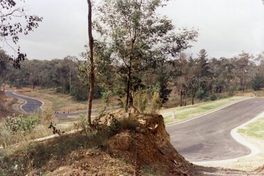
Photograph, Looking west across Werac and Kubis Drives, North Ringwood, in April 1978. Loughnan's Lake site. The retaining wall was where the truck tracks disappear over thhe ridge. The spillway was at that spot
E548 N3 Part of a 51-photo record of the development of the "Kubis" Estate, Ringwood North, including road works to Debbie Place, Kubis Drive, Werac Drive, Manuelo Drive, Iluka Place and Glenvale Road. From the Jack Lundy Clarke collection. -
 Ringwood and District Historical Society
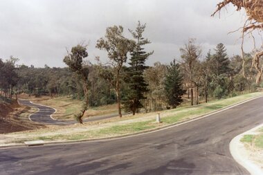
Photograph, Looking east up the gully over the intersection of Werac and Kubis Drives, North Ringwood, in February 1978
E546 N3 Part of a 51-photo record of the development of the "Kubis" Estate, Ringwood North, including road works to Debbie Place, Kubis Drive, Werac Drive, Manuelo Drive, Iluka Place and Glenvale Road. From the Jack Lundy Clarke collection. -
 Ringwood and District Historical Society
Photograph, Corner of Pamela Court and Kubis Drive, North Ringwood, looking west on 3rd November 1978
E551 N15 Part of a 51-photo record of the development of the "Kubis" Estate, Ringwood North, including road works to Debbie Place, Kubis Drive, Werac Drive, Manuelo Drive, Iluka Place and Glenvale Road. From the Jack Lundy Clarke collection. -
 Ringwood and District Historical Society
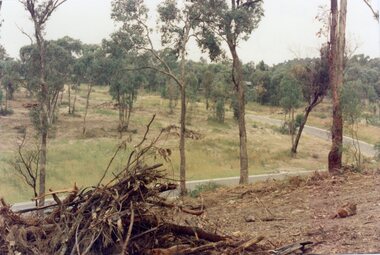
Photograph, "Kubis Estate", North Ringwood, in April 1978. Looking north-east over Loughnan's Lake greatest width. The rope tree was on the slope in the centre. The spillway was on the near left of the image
E548 N17 Part of a 51-photo record of the development of the "Kubis" Estate, Ringwood North, including road works to Debbie Place, Kubis Drive, Werac Drive, Manuelo Drive, Iluka Place and Glenvale Road. From the Jack Lundy Clarke collection. -
 Ringwood and District Historical Society
Photograph, Kubis Estate, North Ringwood in April 1978. Looking west over site of Loughnan's Lake. The rope tree was on the slope to the right beyond the ridge with the lone pine
E548 N15 Part of a 51-photo record of the development of the "Kubis" Estate, Ringwood North, including road works to Debbie Place, Kubis Drive, Werac Drive, Manuelo Drive, Iluka Place and Glenvale Road. From the Jack Lundy Clarke collection. -
 Ringwood and District Historical Society
Photograph, Loughnan Lake site over Kubis Drive, North Ringwood, on 14 April 1978. The retaining wall was where the car tracks disappear over the ridge where the spillway was
E548 N13 Part of a 51-photo record of the development of the "Kubis" Estate, Ringwood North, including road works to Debbie Place, Kubis Drive, Werac Drive, Manuelo Drive, Iluka Place and Glenvale Road. From the Jack Lundy Clarke collection. -
 Ringwood and District Historical Society
Photograph, Junction of Kubis Drive and Iluka Court, North Ringwood, in February 1979. Looking south with Hubbard Reserve beyond
E552 N25 Part of a 51-photo record of the development of the "Kubis" Estate, Ringwood North, including road works to Debbie Place, Kubis Drive, Werac Drive, Manuelo Drive, Iluka Place and Glenvale Road. From the Jack Lundy Clarke collection. -
 Ringwood and District Historical Society
Photograph, The Telecom gang laying pipes in Kubis Drive, North Ringwood, near Jenkins Close, on 10th June 1978
E550 N5 Part of a 51-photo record of the development of the "Kubis" Estate, Ringwood North, including road works to Debbie Place, Kubis Drive, Werac Drive, Manuelo Drive, Iluka Place and Glenvale Road. From the Jack Lundy Clarke collection. -
 Ringwood and District Historical Society
Photograph, Kubis Estate, North Ringwood in April 1978. Looking upstream from below the retaining wall of Loughnan's Lake that was where the truck tracks disappear. The wall was extended to the left across what was then a small gorge
E548 N19 Part of a 51-photo record of the development of the "Kubis" Estate, Ringwood North, including road works to Debbie Place, Kubis Drive, Werac Drive, Manuelo Drive, Iluka Place and Glenvale Road. From the Jack Lundy Clarke collection. -
 Ringwood and District Historical Society
Photograph, Kubis Estate, North Ringwood in April 1978. Looking west across Kubis and Werac Drives over the full length of Loughnan's Lake site. Main pool was behind the lone pine
E548 N29 Part of a 51-photo record of the development of the "Kubis" Estate, Ringwood North, including road works to Debbie Place, Kubis Drive, Werac Drive, Manuelo Drive, Iluka Place and Glenvale Road. From the Jack Lundy Clarke collection. -
 Ringwood and District Historical Society
Photograph, Kubis Estate, North Ringwood in April 1978. Looking up the hill in Kubis Drive from the site of headwaters of Loughnan's Lake. Jenkins Close takes off to the right from centre
E548 N31 Part of a 51-photo record of the development of the "Kubis" Estate, Ringwood North, including road works to Debbie Place, Kubis Drive, Werac Drive, Manuelo Drive, Iluka Place and Glenvale Road. From the Jack Lundy Clarke collection. -
 Ringwood and District Historical Society
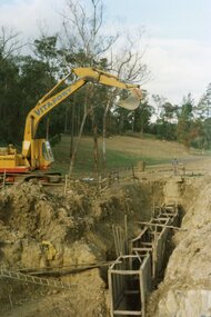
Photograph, Kubis Estate, North Ringwood on 16 June 1978. Kato working on final trench. The hole for the 27 feet deep well is seen beyond the trench
E550 N10 Part of a 51-photo record of the development of the "Kubis" Estate, Ringwood North, including road works to Debbie Place, Kubis Drive, Werac Drive, Manuelo Drive, Iluka Place and Glenvale Road. From the Jack Lundy Clarke collection. -
 Ringwood and District Historical Society
Photograph, Kubis Estate, North Ringwood in February 1978. The site of Loughnan's Lake seen from the north end of the wall. The rope tree was on the hillside on the left
E546 N2 Part of a 51-photo record of the development of the "Kubis" Estate, Ringwood North, including road works to Debbie Place, Kubis Drive, Werac Drive, Manuelo Drive, Iluka Place and Glenvale Road. From the Jack Lundy Clarke collection. -
 Ringwood and District Historical Society
Photograph, Kubis Estate, North Ringwood on 10 June 1978. Temporary end of Kubis Drive at junction with Debbie Place. The car stands at junction with Pamela Place
E550 N8 Part of a 51-photo record of the development of the "Kubis" Estate, Ringwood North, including road works to Debbie Place, Kubis Drive, Werac Drive, Manuelo Drive, Iluka Place and Glenvale Road. From the Jack Lundy Clarke collection. -
 Ringwood and District Historical Society
Photograph, Kubis Estate, North Ringwood in April 1978. View east up Kubis Drive over Jenkin Close and intersection with Werac Drive
E549 N18 Part of a 51-photo record of the development of the "Kubis" Estate, Ringwood North, including road works to Debbie Place, Kubis Drive, Werac Drive, Manuelo Drive, Iluka Place and Glenvale Road. From the Jack Lundy Clarke collection. -
 Ringwood and District Historical Society
Photograph, Kubis Estate, North Ringwood in April 1978. View east up Kubis Drive from Jenkin Close past the foot of Werac Drive
E549 N16 Part of a 51-photo record of the development of the "Kubis" Estate, Ringwood North, including road works to Debbie Place, Kubis Drive, Werac Drive, Manuelo Drive, Iluka Place and Glenvale Road. From the Jack Lundy Clarke collection. -
 Ringwood and District Historical Society
Photograph, Kubis Estate, North Ringwood on 16 June 1978. The Kato lifts a bucket out of the trench
E550 N11 Part of a 51-photo record of the development of the "Kubis" Estate, Ringwood North, including road works to Debbie Place, Kubis Drive, Werac Drive, Manuelo Drive, Iluka Place and Glenvale Road. From the Jack Lundy Clarke collection. -
 Ringwood and District Historical Society
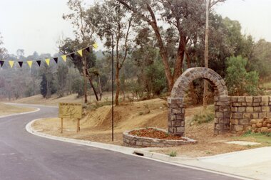
Photograph, Werac Drive, North Ringwood, entrance to Bel-Air Country Club in April 1978
E548 N11 Part of a 51-photo record of the development of the "Kubis" Estate, Ringwood North, including road works to Debbie Place, Kubis Drive, Werac Drive, Manuelo Drive, Iluka Place and Glenvale Road. From the Jack Lundy Clarke collection. -
 Ringwood and District Historical Society
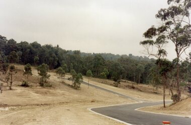
Photograph, View across junction of Wera (lower) and Manuelo (upper) Drives, North Ringwood showing how undergrowth had been cleared, February 1979
B552 N17 Part of a 51-photo record of the development of the "Kubis" Estate, Ringwood North, including road works to Debbie Place, Kubis Drive, Werac Drive, Manuelo Drive, Iluka Place and Glenvale Road. From the Jack Lundy Clarke collection.