Showing 17 items matching "golden square mine sites"
-
 Bendigo Historical Society Inc.
Document - CENTRAL DEBORAH GOLD MINE : GOLDEN SQUARE MINE SITES
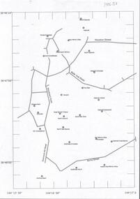
... CENTRAL DEBORAH GOLD MINE : GOLDEN SQUARE MINE SITES......golden square mine sites...History House 11 Mackenzie Street Bendigo goldfields BENDIGO Mining golden square mine sites Map showing mines in the Golden Square, Diamond Hill area. ...Map showing mines in the Golden Square, Diamond Hill area. Roads include Diamond Hill Road, Burns Street, Woodward Road, Belle Vue Road, Houston Street. Latitude and Longitude on map.bendigo, mining, golden square mine sites -
 Bendigo Historical Society Inc.
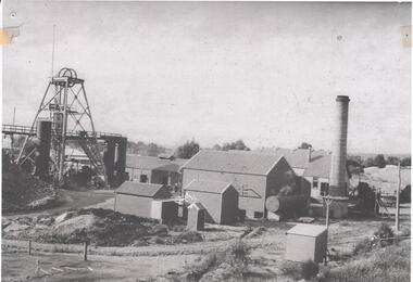
Photograph - DEBORAH GOLD MINE 1930'S
... Deborah mine was near the junction of Abel and Adam Street, Golden Square. Image shows the mine site, a square brick chimney on the extreme RH side, engine room and stamper sheds in the middle and steel poppet head on LH side. ...Deborah mine was near the junction of Abel and Adam Street, Golden Square. Image shows the mine site, a square brick chimney on the extreme RH side, engine room and stamper sheds in the middle and steel poppet head on LH side. ...Black and white photograph, copy, of the Big Deborah Gold Mine, possibly taken in the 1930's. Deborah mine was near the junction of Abel and Adam Street, Golden Square. Image shows the mine site, a square brick chimney on the extreme RH side, engine room and stamper sheds in the middle and steel poppet head on LH side. Colour photo of Big Deborah, minus less the winding wheels at the top of the poppet legs.bendigo, mining, deborah gold mine -
 Bendigo Historical Society Inc.
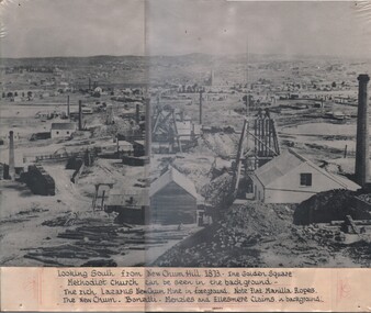
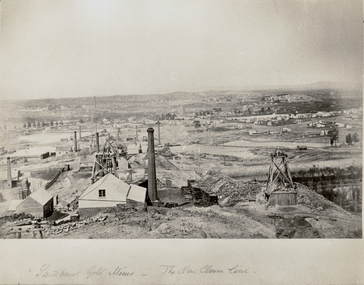
Photograph - LOOKING SOUTH FROM NEW CHUM HILL, 1873
... History House 11 Mackenzie Street Bendigo goldfields PLACE Mining site new chum Black and white photograph, looking south from New Chum Hill. 1873. The Golden Square Methodist Church can be seen in the background. The rich Lazarus New Chum Mine ...Black and white photograph, looking south from New Chum Hill. 1873. The Golden Square Methodist Church can be seen in the background. The rich Lazarus New Chum Mine in foreground. Note Flat Manilla Ropes. The New Chum - Bonatti - Menzies and Ellesmere Claims in background.place, mining site, new chum -
 Bendigo Historical Society Inc.
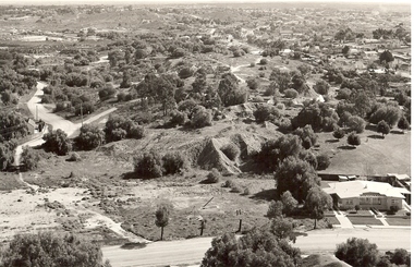
Photograph - VIEW OF MINING AREA - VICTORIA HILL
... site victoria hill Bendigo mines and mining landscape mining landscape mullock heaps Robert Wallace Black and white photograph. View overlooking north from Victoria Hill, mullock heaps, houses - some mid to late 20th century and some miner's cottages, formed road, children's playground centre foreground. Inscriptions: on back - purple rubber stamp 'Robert Wallace Studios, 6 Ruth Street, Golden Square ...Black and white photograph. View overlooking north from Victoria Hill, mullock heaps, houses - some mid to late 20th century and some miner's cottages, formed road, children's playground centre foreground. Inscriptions: on back - purple rubber stamp 'Robert Wallace Studios, 6 Ruth Street, Golden Square, Phone Bgo 37565.Robert Wallaceplace, mining site, victoria hill, bendigo, mines and mining, landscape, mining landscape, mullock heaps -
 Bendigo Historical Society Inc.
Photograph - THE NEW CHUM LINE OF REEF, c.1870
... site. Mines in foreground. Homes in background. Looking South towards Golden Square. ...site. Mines in foreground. Homes in background. Looking South towards Golden Square. ...Black and white photograph. Large view of the New Chum Line mining site. Mines in foreground. Homes in background. Looking South towards Golden Square. Inscriptions: on front - handwritten - 'Sandhurst Gold Mines - The New Chum Line'. C1873, earlier than NH Caire (1875) - James Lerk 12.11.1999.place, mining site, new chum -
 Bendigo Historical Society Inc.
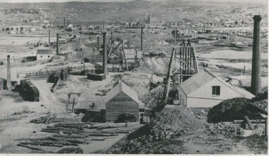
Photograph - MINING AREA VIEW FROM NEW CHUM HILL, 1875
... site See also 2001.003.01 N J Caire Black and white photograph. View overlooking mining area from New Chum Hill in the early 1870's showing four poppet legs and at least 9 chimneys (small chimneys and poppets at L distance). Golden Square Methodist Church C distance. Inscriptions: typed on front 'Looking South from New Chum Hill in early 1970's. The rich :Lazarus New Chum: in foreground. Other rich New Chum Mines ...Black and white photograph. View overlooking mining area from New Chum Hill in the early 1870's showing four poppet legs and at least 9 chimneys (small chimneys and poppets at L distance). Golden Square Methodist Church C distance. Inscriptions: typed on front 'Looking South from New Chum Hill in early 1970's. The rich :Lazarus New Chum: in foreground. Other rich New Chum Mines in background'N J Caireplace, mining site, see also 2001.003.01 -
 Bendigo Historical Society Inc.
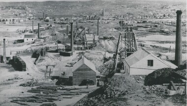
Photograph - MINING AREA VIEW FROM NEW CHUM HILL, 1875
... site see also 2001.004.01 N.J. Caire Black and white photograph. View overlooking mining area from New Chum Hill in the early 1870's showing four poppet legs and at least nine chimneys (small chimneys and poppets at L distance). Golden Square Methodist Church, Laurel Street C distance. Inscriptions on back: 'MNG 21' and round 'Historical society of Victoria, Bendigo Branch' stamp. Typed on front: 'Looking South from New Chum Hill in early 1870's. The rich 'Lazarus New Chum' in foreground. Other rich New Chum Mines ...Black and white photograph. View overlooking mining area from New Chum Hill in the early 1870's showing four poppet legs and at least nine chimneys (small chimneys and poppets at L distance). Golden Square Methodist Church, Laurel Street C distance. Inscriptions on back: 'MNG 21' and round 'Historical society of Victoria, Bendigo Branch' stamp. Typed on front: 'Looking South from New Chum Hill in early 1870's. The rich 'Lazarus New Chum' in foreground. Other rich New Chum Mines in background'. History of object: Previous Acc. No. 'MNG 21', James Lerk, 26.11.1999, N.J. Caire, photograph 1875'.N.J. Caireplace, mining site, see also 2001.004.01 -
 Bendigo Historical Society Inc.
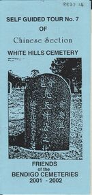
Document - BENDIGO CEMETERIES COLLECTION: SELF GUIDED TOUR NO.7 DOCUMENT
... sites, with descriptions e.g. Louey Ah Pon, passenger involved in a fatal car accident with a bus on High St., a market gardener of Golden Square. Chung Fook Jao, committed suicide in his hut on the New Chum Mine...sites, with descriptions e.g. Louey Ah Pon, passenger involved in a fatal car accident with a bus on High St., a market gardener of Golden Square. Chung Fook Jao, committed suicide in his hut on the New Chum Mine ...BHS CollectionBlue coloured document, trifold. Self Guided Tour No. 7 of Chinese Section, White Hills Cemetery, Friends of the Bendigo Cemeteries 2-001 - 2002. Theme 'A hundred years after Federation' Map with numbered grave sites, with descriptions e.g. Louey Ah Pon, passenger involved in a fatal car accident with a bus on High St., a market gardener of Golden Square. Chung Fook Jao, committed suicide in his hut on the New Chum Mine site where he had worked the tailing for many years.Friends of the Bendigo Cemeteries 2000bendigo, cemetery, white hills cemetery tour -
 Bendigo Historical Society Inc.
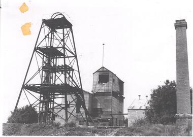
Photograph - NORTH DEBORAH GOLD MINE GOLDEN SQUARE
... Mine, 1940's. View of entire site showing poppet head, trestleway, engine house, chimney stack. Two ore bins to the right of poppet head. 1920's vehicle on far right of photo. Country style outhgouse in foreground of photo. Chimney stack on RH side. Photograph NORTH DEBORAH GOLD MINE GOLDEN SQUARE ...Black and white photograph of North Deborah Gold Mine, 1940's. View of entire site showing poppet head, trestleway, engine house, chimney stack. Two ore bins to the right of poppet head. 1920's vehicle on far right of photo. Country style outhgouse in foreground of photo. Chimney stack on RH side. -
 Bendigo Historical Society Inc.
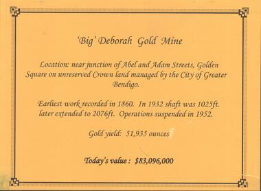
Photograph - DEBORAH GOLD MINE, GOLDEN SQUARE
... Mine, located near the junction of Abel and Adam Street, Golden Square. Earliest work recorded 1860. Shaft 2076 feet. Operations suspended in 1952. Gold yield 51,935 ounces. Battery shed still on site...Mine, located near the junction of Abel and Adam Street, Golden Square. Earliest work recorded 1860. Shaft 2076 feet. Operations suspended in 1952. Gold yield 51,935 ounces. Battery shed still on site ...Information display card regarding the 'Big' Deborah Gold Mine, located near the junction of Abel and Adam Street, Golden Square. Earliest work recorded 1860. Shaft 2076 feet. Operations suspended in 1952. Gold yield 51,935 ounces. Battery shed still on site containing a 5 head stamper which was originally a 20 head stamper. The battery was manufactured by Horwood's Foundry, Bendigo. Photos of mine site taken in 2012: a.Engine room concrete footings, iron work visible. Pepper corn trees in background. Pampas grass in foreground. Steel mesh fence on RH side, enclosing the poppet head site. b. Concrete footings, peppercorn tree in background. c. Corrugated iron shed constructed over the stampers. Steel mesh front. d. Steel poppet head, no winding wheel at top. Pampas grass in foreground. e.. Stamper shed and steel poppet legs in background enclosing dilapidated wooden poppet head legs. f. Close up image of weights in stamper room g.Winding wheel on stampers h.Looking upwards to top of stampersbendigo, mining, deborah gold mine -
 Bendigo Historical Society Inc.
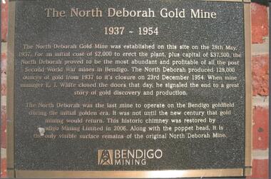
Photograph - NORTH DEBORAH GOLD MINE BENDIGO MINING PLAQUE
... mine to operate on the Bendigo goldfield during the initial golden era. It was not until the new century that gold mining would return. This historic chimney was restored by Bendigo Mining Limited in 2006. Along with the poppet head. It is the only visible surface remains of the original North Deborah Mine.' The mine site is situated off Breen Street in Golden Square...mine to operate on the Bendigo goldfield during the initial golden era. It was not until the new century that gold mining would return. This historic chimney was restored by Bendigo Mining Limited in 2006. Along with the poppet head. It is the only visible surface remains of the original North Deborah Mine.' The mine site is situated off Breen Street in Golden Square ...Metal plaque, gold writing, erected at the site of the former North Deborah Gold Mine when the brick chimney was restored by Bendigo Mining NL. The plaque reads: 'The North Deborah Gold Mine, 1937-1954. The North Deborah Gold mine was established on this site on the 28th May 1937. For an initial cost of 2,000 pounds to erect the plant, plus capital of 37,500 pounds, the North Debnorah proved to be the most abundant and profitable of all the post Second War mines in Bendigo. The North Deborah produced 128,000 ounces of gold from 1937 to its closure on 23rd December 1954. When mine manager E.J. White closed the doors that day he signaled the end to a great story of gold discovery and production. The North Deborah was the last mine to operate on the Bendigo goldfield during the initial golden era. It was not until the new century that gold mining would return. This historic chimney was restored by Bendigo Mining Limited in 2006. Along with the poppet head. It is the only visible surface remains of the original North Deborah Mine.' The mine site is situated off Breen Street in Golden Square.Kay MacGregor 2012bendigo, mining, north deborah mining company -
 Bendigo Historical Society Inc.
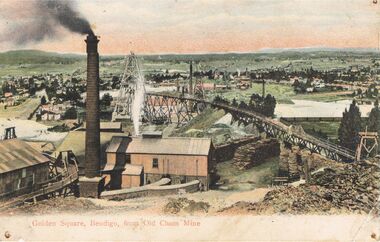
Postcard - GOLDEN SQUARE, BENDIGO FROM ' OLD CHUM' MINE
... Postcard: hand coloured image showing mine site in Golden Square. Brick chimney in foreground, sheds. ...History House 11 Mackenzie Street Bendigo goldfields BENDIGO Mining old chum mine golden square Old Chum Mine Golden Square postcard G.W.W. Postcard: hand coloured image showing mine site in Golden Square. ...Postcard: hand coloured image showing mine site in Golden Square. Brick chimney in foreground, sheds. Tramway from LH side to poppet head behind chimney. On back of card ' Post GWW Card' Printed partly in Great Britain and partly in Germany. In black ink ' Dear Muncie Bob, I hope you arrived all right. I suppose you have started work before this. I don't start till 10th. Feb.' A stamp has been drawn, showing a house and written ' little house on the hill' Dated 1913.G.W.W.bendigo, mining, old chum mine, golden square, old chum mine, golden square, postcard -
 Bendigo Historical Society Inc.
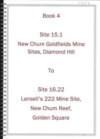
Book - NEW CHUM GOLDFIELDS MINE SITE DIAMOND HILL TO LANSELL'S 222 MINE SITE NEW CHUM REEF GOLDEN SQUARE, 1992
... NEW CHUM GOLDFIELDS MINE SITE DIAMOND HILL TO LANSELL'S 222 MINE SITE NEW CHUM REEF GOLDEN SQUARE...Book 4, Site 15.1 New Chum Goldfields Mine site Diamond Hill to site 16.22, Lansell's 222 Mine site, New Chum Reef, Golden Square. ...History House 11 Mackenzie Street Bendigo goldfields BENDIGO Mining goldfields report Bendigo gold goldfields history David Bannear Book 4, Site 15.1 New Chum Goldfields Mine site Diamond Hill to site 16.22, Lansell's 222 Mine site, New Chum Reef, Golden Square. ...Book 4, Site 15.1 New Chum Goldfields Mine site Diamond Hill to site 16.22, Lansell's 222 Mine site, New Chum Reef, Golden Square. Significance reports prepared for North Central Goldfields Project: Bendigo Goldfield.David Bannearbendigo, mining, goldfields report, bendigo, gold, goldfields, history -
 Bendigo Historical Society Inc.
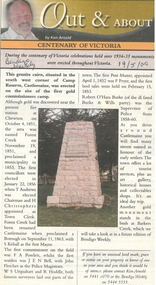
Newspaper - Newspaper articles by Ken Arnold, Out &About, 2000 - 2003
... sites Landmarks A series of one hundred and thirty-five articles written by Ken Arnold and published in the Bendigo Weekly between 2000 and 2003. Each article has a topic or theme and includes historical information and details. Each article includes a photograph. The articles are stored in a red vinyl covered two ring A5 folder. Index below. Number Article Name Date 1. Centenary of Victoria 19.5.00 2. Storm Water Drain 26.5.00 3. Granite Rollers 2.6.00 4. Poverty Mine 9.6.00 5. Golden Monument. St Arnaud 16.6.00 6. Turner Statue 7.7.00 7. Gold Monument. High St Golden Square ...Ken Arnold is a Bendigo author and publisher.A series of one hundred and thirty-five articles written by Ken Arnold and published in the Bendigo Weekly between 2000 and 2003. Each article has a topic or theme and includes historical information and details. Each article includes a photograph. The articles are stored in a red vinyl covered two ring A5 folder. Index below. Number Article Name Date 1. Centenary of Victoria 19.5.00 2. Storm Water Drain 26.5.00 3. Granite Rollers 2.6.00 4. Poverty Mine 9.6.00 5. Golden Monument. St Arnaud 16.6.00 6. Turner Statue 7.7.00 7. Gold Monument. High St Golden Square 30.6.00 8. Gold Monument. Howard Square Bendigo 14.7.00 9. Lansell Statue 21.7.00 10. Shelbourne West School 18.8.00 11. Mologa’s State Schools 25.8.00 12. Salinity Stone. Pyramid Hill 1.9.00 13. Cairn. Carisbrook 8.9.00 14. Commemorative Markers. Taradale 15.9.00 15. Burke Monument. Castlemaine 22.9.00 16. Cairn. Harcourt area 29.9.00 17. Cairn Marks Gold Route 6.10.00 18. Volcanic Rock Cairn. Woodstock 13.10.00 19. Garfield Water Wheel 20.10.00 20. Anticline. Castlemaine 27.10.00 21. Lawson Bridge 10.11.00 22. Plaque. Sutton Grange area 17.11.00 23. Memorial Cairn. Maryborough 1.12.00 24. Lonely Grave 8.12.00 25. Moonlight Flat Church 5.1.01 26. Historic Church. Near Tullaroop reservoir 12.1.01 27. Granite Statue. Castlemaine 19.1.01 28. Marker. Near Tullaroop reservoir 25.1.01 29. Church Site. Mologa 2.2.01 30. Church Site. Mologa 9.2.01 31. Plaque. Mologa 16.2.01 32. Mincha School 23.2.01 33. Historic Marker. Mincha 2.3.01 34. Expedition Marker. Pyramid Hill 9.3.01 35. Irrigation Marker. Tragowel 16.3.01 36. Mologa School Sites 23.3.01 37. Cairn. Pyramid Hill 30.3.01 38. Plaque. Pyramid Hill 6.4.01 39. Bristol Hill Lookout Tower. Maryborough 12.4.01 40. Eppalock Reservoir 20.4.01 41. Colbinabbin Cairn 27.4.01 42. Mount Macedon Cross 4.5.01 43. Memorial Gateway. Macedon 11.5.01 44. Cairn. Daylesford 18.5.01 45. Grave. Carlsruhe 25.5.01 46. Water Tower. Elmore 1.6.01 47. State School Site. Glenalbyn 8.6.01 48. Cairn. Kanya 15.6.01 49. Lonely Grave. Wedderburn 22.6.01 50. Church Cairn. Glenalbyn 29.6.01 51. Kamarooka School 6.7.01 52. Granite Marker. Moyston 13.7.01 53. Memorial Park. Kerang 20.7.01 54. Water Plaque. Bears Lagoon 27.7.01 55. Cemetery. Bears Lagoon 3.8.01 56. Race Monument 10.8.01 57. Cairn. Pyalong 17.8.01 58. Cairn. In memory of Edward Parker 24.8.01 59. Mt Macedon 31.8.01 60. Mt Macedon Cairn 7.9.01 61. Expedition Pass. Chewton 14.9.01 62. Granite Archway. St Arnaud 21.9.01 63. Stuart Mill School Site 28.9.01 64. School Site. Beazley’s Bridge 5.10.01 65. Fosterville 12.10.01 66. Barnadown 19.10.01 67. Salisbury School Site 26.10.01 68. Cricket History at Wattle Flat 2.11.01 69. School Site. Waterloo Plains 9.11.01 70. Carapooee School Site 11.01 71. Turkish Gun. Maldon 11.01 72. Kooreh 30.11.01 73. Marnoo East School 7.12.01 74. Bulgana Site 14.12.01 75. Emu School 21.12.01 76. Kooroocheang 4.1.02 77. Church Site. Gre Gre North 11.1.02 78. Carmens Tunnel. Maldon 18.1.02 79. Monument. Maldon 25.1.02 80. Woodfull Plaques. Maldon 1.2.02 81. Carapooee. St Peters Anglican Church 8.2.02 82. Cairn. Kingower 15.2.02 83. Cob & Co Stopover. Rheola 22.2.02 84. Flynn Monument 1.3.02 85. The Welcome Stranger. Moliagul 8.3.02 86. Campbell’s Creek Reserve 15.3.02 87. Mine. Fryerstown 22.3.02 88. Escott Grave. Near Chewton 28.3.02 89. School No 808. Kurting area 5.4.02 90. Graves. Bendigo Creek 10.5.02 91. School. Fish Point, Benjeroop North 17.5.02 92. Old Township. Diggora 24.5.02 93. Diggora West (1) 31.5.02 94. Diggora West (2) 7.6.02 95. School No 2735. Gower East 14.6.02 96. Pannoomilloo 21.6.02 97. Kamarooka Settlement 28.6.02 98. Mincha West State School No 1931 5.7.02 99. Bridges. Arnold 12.7.02 100. Woodvale 19.7.02 101. A Famous Son of Raywood. Jack Donaldson 26.7.02 102. Tandarra Area Schools 2.8.02 103. Dingee 9.8.02 104. Avonmore 30.8.02 105. Myola East School 6.9.02 106. Colbinabbin West 13.9.02 107. Colbinabbin West School 20.9.02 108. Runnymede area 27.9.02 109. Wanalta 4.10.02 110. School Sites. Between Wanalta and Carop 11.10.02 111. Burramboot 18.10.02 112. Kangaroo Chair. 25.10.02 113. Mincha South 1.11.02 114. Woodlands Church 8.11.02 115. School site. Sylvaterre 15.11.02 116. Terrick Terrick 22.11.02 117. Leitchville 29.11.02 118. Pennyweight Cemetery. Castlemaine 6.12.02 119. Mincha Area 13.12.02 120. Musk School 20.12.02 121. Dowie Park. Carisbrook 3.1.03 122. Neereman School Site 10.1.03 123. Bald Rock 17.1.03 124. Sylvaterre School Site 24.1.02 125. Carlsruhe 31.1.02 126. Athenaeum. Maldon 7.2.03 127. School. Mincha West 14.2.03 128. Yarraberb 21.2.03 129. Settlement Marker. Ravenswood Estate 28.2.03 130. Comini Reserve. Ravenswood 7.3.03 131. Ironbark and Gold Track. Whroo 14.3.03 132. Burke and Wills Obelisk. Castlemaine 21.3.03 133. James Cook Statue. Myers St Bendigo 28.3.03 134. St Marys Church. Axedale 4 .4.03 135. Butter Factory Site. Warragamba 11.4.03 events, monuments, historical sites, landmarks -
 Bendigo Historical Society Inc.
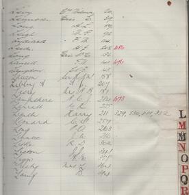
Administrative record - Monument Hill Consolidated Bendigo N.L. Share Register, 1934 to 1940
... mine went into voluntary liquidation in March 1953. Monument Hill Consolidated Bendigo N.L. was situated at 23 Rose Street and Mackenzie Streets, Golden Square, Bendigo. Heritage Inventory Site...mine went into voluntary liquidation in March 1953. Monument Hill Consolidated Bendigo N.L. was situated at 23 Rose Street and Mackenzie Streets, Golden Square, Bendigo. Heritage Inventory Site ...The Monument Hill Consolidated Company was formed in August 1934, with a nominal capital of £62,500, with 125,000 shares at 10/- each. The mine went into voluntary liquidation in March 1953. Monument Hill Consolidated Bendigo N.L. was situated at 23 Rose Street and Mackenzie Streets, Golden Square, Bendigo. Heritage Inventory Site Heritage Inventory (HI) Number H7724-0187 (Victorian Heritage Database) Five hundred page register with green cover, buff coloured binding. On spine: 'Share Register' printed in gold leaf on maroon background, and 'Monument Hill Consolidated (Bendigo) N.L.' on dark green background. Alphabetical index of shareholders names listed in first pages of journal with corresponding journal page numbers providing further details of the share transactions. Dates from 1934 to 1940. Register is part of the Margaret Roberts Collection of mining records.bendigo, gold mining, monument hill consolidated bendigo n.l., share register, shareholders, 1934, margaret roberts collection -
 Bendigo Historical Society Inc.
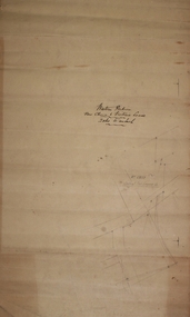
Plan - New Chum and Victoria Lease
... site of extensive quartz reef mining with some of the richest mines of the field, led by George Lansell and Daniel Barnet Lazarus. These included the nearby mine sites of New Chum and Victoria, New Chum United, Old Chum, Lansells 222 and Lazarus as well as operating extensive battery buildings and pyrites works that were all located in New Chum Gully between Booth, Thistle Streets and Maple Street. (City of Greater Bendigo, Heritage Report, 27 Pallett Street, Golden Square...site of extensive quartz reef mining with some of the richest mines of the field, led by George Lansell and Daniel Barnet Lazarus. These included the nearby mine sites of New Chum and Victoria, New Chum United, Old Chum, Lansells 222 and Lazarus as well as operating extensive battery buildings and pyrites works that were all located in New Chum Gully between Booth, Thistle Streets and Maple Street. (City of Greater Bendigo, Heritage Report, 27 Pallett Street, Golden Square ...New Chum Gully is one of the earliest and most important alluvial and quartz mining gully of Bendigo goldfields. It was also one of the more lucrative reefs and became the site of extensive quartz reef mining with some of the richest mines of the field, led by George Lansell and Daniel Barnet Lazarus. These included the nearby mine sites of New Chum and Victoria, New Chum United, Old Chum, Lansells 222 and Lazarus as well as operating extensive battery buildings and pyrites works that were all located in New Chum Gully between Booth, Thistle Streets and Maple Street. (City of Greater Bendigo, Heritage Report, 27 Pallett Street, Golden Square)New Chum and Victoria Lease plan. Written on outside of plan: ' Western Portion, New Chum and Victoria Lease, 2 chains to an inch'. Plan forms part of the Margaret Roberts Collection of mining records. margaret roberts, gold, gold mine, new chum and victoria lease, victoria hill, bendigo -
 Bendigo Historical Society Inc.
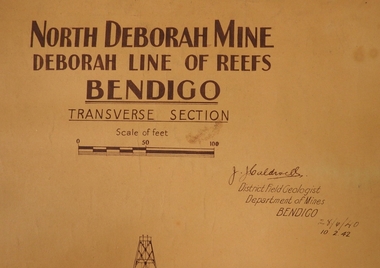
Plan - North Deborah Mine, 28.4.40 and 10.2.42
... North Deborah Gold Mine was located near Eve Street and Breen Street, Golden Square. :The company occupying this site was the leading gold producer of the Deborah line of reef during the 1930's mining revival period. ...North Deborah Gold Mine was located near Eve Street and Breen Street, Golden Square. :The company occupying this site was the leading gold producer of the Deborah line of reef during the 1930's mining revival period. ...North Deborah Gold Mine was located near Eve Street and Breen Street, Golden Square. :The company occupying this site was the leading gold producer of the Deborah line of reef during the 1930's mining revival period. The site is reserved for mining, contains the only brick mine chimney still standing. It is readily accessible, is visible from the Deborah site, Chum Hill and various other places around central Bendigo, and has views both to Chum Hill and the Deborah site.Light tan heavy paper plan. Written on top in bold black text: ' North Deborah Mine, Deborah Line of Reef, Bendigo, Transverse Section' Signed by J.J. Caldwell. Printed under name: 'District Field Geologist, Department of Mines, Bendigo' 28.4.40 and 10.2.42, printed under title. Plan shows poppet head, shaft and levels. Plan forms part of the Margaret Roberts Collection.gold mining, gold, bendigo, north deborah gold mine, eve street, breen street, golden square, transverse section