Showing 28 items matching "golf - kew (vic)"
-
 Kew Historical Society Inc
Archive (Sub-series) - Subject File, Kew Historical Society, Green Acres Golf Club, 1958
... ...sports - kew (vic)...golf...Typically files will contain primary and secondary sources. kew historical society - archives sports - kew (vic) golf - kew (vic) Small archive file on the Green Acres Golf Club containing newspaper articles/cuttings and some promotional brochures produced by the Club. ...Various partiesReference, Research, InformationSecondary Values (KHS Imposed Order)Small subject file on the Green Acres Golf Club containing newspaper articles/cuttings and some promotional brochures produced by the Club.kew historical society - archives, sports - kew (vic), golf - kew (vic)kew historical society - archives, sports - kew (vic), golf - kew (vic) -
 Kew Historical Society Inc
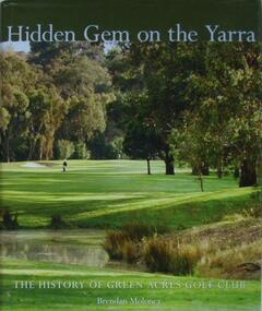
Book - Volume, Hidden Gem on the Yarra: The history of the Green Acres Golf Club / by Brendan Moloney
... ...golf clubs - kew (vic)...Kew Historical Society Inc Kew Court House 188 High Street Kew melbourne green acres golf club golf clubs - kew (vic) History of Greenacres Golf Club Hidden Gem on the Yarra: The history of the Green Acres Golf Club / by Brendan Moloney Book Volume ...History of Greenacres Golf Clubnon-fictiongreen acres golf club, golf clubs - kew (vic) -
 Kew Historical Society Inc
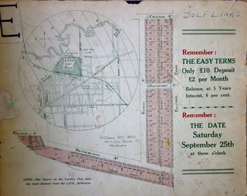
Plan - Subdivision Plan, H C Crouch, Old Golf Links Estate, 1930s
... Subdivisions -- Kew (Vic.)...Old Golf...Subdivisions -- Kew (Vic.) Old Golf Links Estate Annotations: "E" top left. ...The land in North Kew between the Outer Circle Railway and the River Yarra was released in sections. This release included 80 lots. Most of this area was released during the Depression years in the early 1930s.Subdivision plans are historically important documents used as evidence of the growth of suburbs in Australia. They frequently provide information about when the land was sold on which a built structure was subsequently constructed as well as evidence relating to surveyors and real estate and financial agents. The numerous subdivision plans in the Kew Historical Society's collection represent working documents, ranging from the initial sketches made in planning a subdivision to printed plans on which auctioneers or agents listed the prices for which individual lots were sold. In a number of cases, the reverse of a subdivision plan in the collection includes a photograph of a house that was also for sale by the agent. These photographs provide significant heritage information relating house design and decoration, fencing and household gardens.One part of a massive subdivision of the Old Golf Links Estate in North Kew of 80 allotments bordering Sutherland Avenue, Ramsay Avenue, Belford Road, Beresford Street and Coleman Avenue. Inset on the plan at the top left, the route of the Outer Circle Railway is clearly marked. The Kew Golf Links is identified in its current location. The land on which Greenacres Golf Club was to be constructed is at this time marked as ‘Recreation Ground’. The ‘new bridge’ over the Yarra at Burke Road is also marked on the inset map. The Plan identifies the surveyor (sic) H.C. Crouch BCE MVIS, 443 Little Collins St., Melbourne. The date of the subdivision auction sale in identified as Saturday September 25th at three o'clock.Annotations: "E" top left. "Golf Links" top right. Lots 73-76 ticked and listed as "6" poundssubdivisions -- kew (vic.), old golf links estate -
 Kew Historical Society Inc
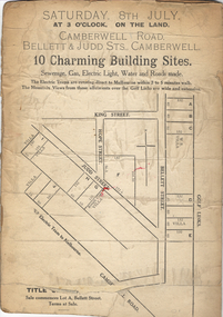
Plan - Subdivision Plan, 10 Charming Building Sites, 1930-1940
... Kew melbourne subdivision plans -- Camberwell (Vic.) This subdivision plan shows 10 lots, numbered A-J, that were offered for sale in Camberwell. Streets in the subdivision include Camberwell Road, Judd Street, Bellett Street and King Street. The plan lists existing houses in the vicinity including weatherboard and ‘Rough Cast’ villas. The old Golf ...This subdivision plan shows 10 lots, numbered A-J, that were offered for sale in Camberwell. Streets in the subdivision include Camberwell Road, Judd Street, Bellett Street and King Street. The plan lists existing houses in the vicinity including weatherboard and ‘Rough Cast’ villas. The old Golf Links are identified at the rear of the Bellett Street lots.subdivision plans -- camberwell (vic.) -
Kew Historical Society Inc
Archive (Sub-series) - Subject File, Kew Historical Society et al, JUST, Judge Gordon, 1958
... kew (vic)...richard tyas...green acres golf...Typically files will contain primary and secondary sources. kew historical society - archives kew - history hermann just olive judge, carl judge bowen street - kew (vic) richard tyas green acres golf club betty judge gordon just trinity grammar school just theatre - kew court house judge gordon just Archive file containing information about Judge Gordon Judge, after whom the Just Theatre at the Kew Court House was named. ...Various partiesReference, Research, InformationSecondary Values (KHS Imposed Order)Subject file containing information about Judge Gordon Judge, after whom the Just Theatre at the Kew Court House was named. The file contains a typed address by Don Just, which refers to the family’s historical connections to Kew. The file also includes a number of copies of the order of his funeral service at Le Pines in 2011 and sundry notes and correspondence.kew historical society - archives, kew - history, hermann just, olive judge,, carl judge, bowen street - kew (vic), richard tyas, green acres golf club, betty judge, gordon just, trinity grammar school, just theatre - kew court house, judge gordon justkew historical society - archives, kew - history, hermann just, olive judge,, carl judge, bowen street - kew (vic), richard tyas, green acres golf club, betty judge, gordon just, trinity grammar school, just theatre - kew court house, judge gordon just -
 Kew Historical Society Inc
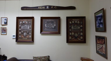
Photograph - Series, Sport in Kew Exhibitions, 2014
... Smaller displays continue to be mounted in the Kew Library. kew historical society - exhibitions exhibition - sport in kew (vic) A series of born digital photographs of an exhibition mounted at the Kew Court House and or Kew Library in 2014 involving photographs and artefacts from the Kew Croquet Club, the Kew Football Club, the Kew Golf Club, the Green Acres Golf Club and the North Kew Tennis Club. ...The Kew Historical Society, founded in 1958, is one of the oldest continuing historical societies in the Greater Melbourne region. From its beginnings, the Society has mounted exhibitions and/or displays, in early days in shop windows and in community spaces located in the Kew City Hall (later Kew Library), and since 2010 at the Kew Court House. Exhibitions typically coincided with the annual Kew Community Festival in March, but after 2013 evolved into three new exhibitions yearly at the Kew Court House. Smaller displays continue to be mounted in the Kew Library. A series of born digital photographs of an exhibition mounted at the Kew Court House and or Kew Library in 2014 involving photographs and artefacts from the Kew Croquet Club, the Kew Football Club, the Kew Golf Club, the Green Acres Golf Club and the North Kew Tennis Club. kew historical society - exhibitions, exhibition - sport in kew (vic) -
Kew Historical Society Inc
Archive (Sub-series) - Subject File, Kew Historical Society, HODDLE Survey, 1997
... Typically files will contain primary and secondary sources. kew historical society - archives kew (vic) - history robert hoddle - surveyor hoddle tree - kew (vic) jack hackett Photocopied correspondence and maps (surveys) relating to surveys ordered by Robert Hoddle, Government Surveyor. Authors of letters and information include Gwen McWilliam and Jack Hackett. Much of the correspondence relates to the site of the ‘Hoddle Tree’, currently located in the Kew Golf ...Various partiesReference, Research, InformationSecondary Values (KHS Imposed Order)Photocopied correspondence and maps (surveys) relating to surveys ordered by Robert Hoddle, Government Surveyor. Authors of letters and information include Gwen McWilliam and Jack Hackett. Much of the correspondence relates to the site of the ‘Hoddle Tree’, currently located in the Kew Golf Course. Jack Hackett’s original map is contained in the map drawers in the Society’s archive.kew historical society - archives, kew (vic) - history, robert hoddle - surveyor, hoddle tree - kew (vic), jack hackettkew historical society - archives, kew (vic) - history, robert hoddle - surveyor, hoddle tree - kew (vic), jack hackett -
 Kew Historical Society Inc
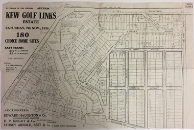
Plan - Subdivision Plan, Kew Golf Links Estate, 1936, 1936
... Kew Golf Links Estate was a major subdivision of farmland in Kew. The site was at one stage designated for industrial development and the building of a new Kodak factory. The decision by Council to oppose the redevelopment makes the beginning of the period when all industrial development was banned in Kew. subdivision plans - kew (vic) kodak factory - kew (vic) Monochrome printed, folded subdivision plan for the Kew Golf Links Estate, to be auctioned on 7 November 1936. ...The Kew Golf Links Estate was a major subdivision in North Kew. It derived its title due to the land being previously occupied by the Kew Golf Club, which transferred its course to a number of locations before occupying its current site. The Plan advertises 180 choice home sites. The street names are somewhat different today as those on the map are named after the proposed Kodak Factory to be built on the site. The subdivision of the Kew Golf Links Estate was a major subdivision of farmland in Kew. The site was at one stage designated for industrial development and the building of a new Kodak factory. The decision by Council to oppose the redevelopment makes the beginning of the period when all industrial development was banned in Kew.Monochrome printed, folded subdivision plan for the Kew Golf Links Estate, to be auctioned on 7 November 1936. Streets named include: Carnegie Avenue, Willsmere Road, Kilby Boulevarde, Kodak Avenue, Coleman Avenue, Beresford Avenue, McConchie Avenue, Cole Avenue, White Avenue, Baker Avenue, Spruzen Avenue, Tanner Avenue, Ratten Avenue, Mathers Avenue, Railway Avenue, Sutherland Avenue, and Belford Road. The position of the Yarra River and a large Drainage Reserve are marked on the plan. Lots for sale are numbered. Existing buildings are designated with a square.subdivision plans - kew (vic), kodak factory - kew (vic) -
 Kew Historical Society Inc
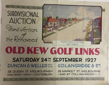
Booklet, Duncan & Weller Pty Ltd, Old Kew Golf Links Estate, 1927, 1927
... subdivisions - kew (vic)...kew golf...Kew Historical Society Inc Kew Court House 188 High Street Kew melbourne The booklet advertises the third sale within the Old Golf Links Estate which was a major subdivision of farmland in North Kew in the 1920s The subdivision of the Kew Golf Links Estate was a major subdivision of farmland in Kew. The site was at one stage designated for industrial development and the building of a new Kodak factory. The decision by Council to oppose the redevelopment makes the beginning of the period when all industrial development was banned in Kew. subdivisions - kew (vic ...The booklet advertises the third sale within the Old Golf Links Estate which was a major subdivision of farmland in North Kew in the 1920sThe subdivision of the Kew Golf Links Estate was a major subdivision of farmland in Kew. The site was at one stage designated for industrial development and the building of a new Kodak factory. The decision by Council to oppose the redevelopment makes the beginning of the period when all industrial development was banned in Kew.6 page illustrated brochure advertising the third section of a major subdivision in Kew in 1927 including 75 charming home allotments and 7 valuable building sites. The brochure includes the subdivision plan. The front cover includes a colour illustration of the almost completed houses in Woolcock Avenue. Streets named include: Kilby Road, Kodak Avenue, Baker Avenue, Mathers Avenue, Coleman Avenue, White Avenue and Belford Road. Lots for sale are numbered. Existing buildings are designated with a square.subdivisions - kew (vic), kew golf links estate -
 Kew Historical Society Inc
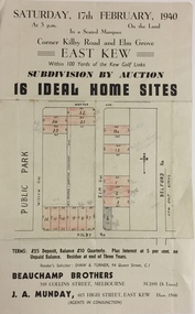
Plan - Subdivision Plan, Subdivision by Auction: 16 Ideal Home Sites, East Kew, 1940, 1940
... Kew Golf Course and Willsmere Park led to the streets having a high degree of architectural uniformity. The subdivision in the second year of the war indicates that land sales for homes and speculation continued from the 1930s into the period of the Second World War. There is no indication on the plan that a war is occurring. subdivision plans - kew east (vic ...An advertisement for the sale of a subdivision by Auction: of 16 Ideal Home Sites, East Kew, 1940. This significant sale of land between the Kew Golf Course and Willsmere Park led to the streets having a high degree of architectural uniformity.The subdivision in the second year of the war indicates that land sales for homes and speculation continued from the 1930s into the period of the Second World War. There is no indication on the plan that a war is occurring.Single page subdivision plan advertising the sale by Auction of 16 Ideal Home Sites, in East Kew, on 17 February 1940. Streets named in the plan include: Kilby Road, Belford Road, Elm Grove, Willow Grove. Willsmere Park is indicated but not named. The auction was conducted by Beauchamp Brothers. A number of lots are coloured pink on the plan indicating those lots for sale and/or those already sold.subdivision plans - kew east (vic) -
![Photograph - Construction of the F19 [Eastern Freeway], Ron Setford, January 1973](/media/collectors/550653872162f11fb04854aa/items/67ff96643b378d43a2a88f8b/item-media/67ff96853b378d43a2a890fb/item-fit-380x285.jpg?cb=6) Kew Historical Society Inc
Kew Historical Society IncPhotograph - Construction of the F19 [Eastern Freeway], Ron Setford, January 1973
... Buildings -- Kew (Vic) -- Kew Golf Club...Ron Setford Eastern Freeway F19 Freeway Buildings -- Kew (Vic) -- Kew Golf Club "Old Kew Golf Club / Freeway thru window INF F10 125" Photograph Construction of the F19 [Eastern Freeway] Ron Setford ...Ron Setford and his wife Grace Setford lived in Tanner Avenue, East Kew, from c.1946 to c.1995. A keen photographer, he recorded the changing face of Kew over a 20 year period. Apart from 30 photographs of built structures and places in Kew dating from 1960 and 1961, 145 of his 35mm colour slides chronicle the development of the F19 (later renamed Eastern) Freeway through the Yarra Valley in Kew over a five year period from c.1972 to c.1977. This important collection was donated to the Society by his granddaughter in 2025.This collection of 175 35mm slides is of local and statewide significance, owing to its subject matter, particularly the major development of road transport infrastructure during the 1970s with the construction of the Eastern Freeway. The photographer also took care to annotate and date most of his slides which enable the researcher to pinpoint temporal and spatial locations."Old Kew Golf Club / Freeway thru window INF F10 125"ron setford, eastern freeway, f19 freeway, buildings -- kew (vic) -- kew golf club -
 Kew Historical Society Inc
Photograph - View from 52 Frater Street, Kew East, 1946
... Kew Historical Society Inc Kew Court House 188 High Street Kew melbourne 52 Frater Street was the home of the Coade family from the second half of the 1940s. 52 Frater Street -- Kew East(Vic.) Coade family Verso: "View ahead, Golf Links, and Northcote from sundeck / Sept '46" View towards Northcote from 52 Frater Street, Kew East Photograph View from 52 Frater Street, Kew East ...52 Frater Street was the home of the Coade family from the second half of the 1940s. View towards Northcote from 52 Frater Street, Kew East Verso: "View ahead, Golf Links, and Northcote from sundeck / Sept '46"52 frater street -- kew east(vic.), coade family -
Kew Historical Society Inc
Journal, Kew Historical Society, Newsletter No.106, March 2014
... Kew Historical Society (Vic.) -- Periodicals. Kew Historical Society (Vic.) -- Newsletters Kew Historical Society (Vic.) -- journals Preserving our heritage [Sports in Kew] / Robert Baker p1-2. Society activities: Exhibitions [Sport in Kew]; 2014 McIntyre Lecture [Sir Gustav Nossal AC CBE]; Past Meetings; Future Meetings; New website / p3. Exhibition - Sport in Kew [Kew Croquet Club, Kew Golf ...Preserving our heritage [Sports in Kew] / Robert Baker p1-2. Society activities: Exhibitions [Sport in Kew]; 2014 McIntyre Lecture [Sir Gustav Nossal AC CBE]; Past Meetings; Future Meetings; New website / p3. Exhibition - Sport in Kew [Kew Croquet Club, Kew Golf Club, Greenacres Golf Club, North Kew Tennis Club; Sacred Heart Tennis Club] / p4-5. Letters to the editor [Tara Hall; Kew Flyer] / Dione McIntyre; Lindsay Goold p5. Scouting in Kew / Brad Miles p6-7. The MMBW Plans of Kew / Robert Baker p8. The Princess Hotel / Robert Baker p9-10. The Noble family of Kew / Judith Vimpani & Robert Baker p10. It happened in the past [150-years ago; 100-years ago; 50 years ago] / p11. Support Kew's history / p11. Mystery House / p12. Book sale / p12. Dates for your diary / p12.Published quarterly since 1977, the newsletters of the Kew Historical Society contain significant research by members exploring relevant aspects of the Victorian and Australian Framework of Historical Themes. Frequently, articles on people, places and artefacts are the only source of information about an aspect of Kew, and Melbourne’s history.non-fictionPreserving our heritage [Sports in Kew] / Robert Baker p1-2. Society activities: Exhibitions [Sport in Kew]; 2014 McIntyre Lecture [Sir Gustav Nossal AC CBE]; Past Meetings; Future Meetings; New website / p3. Exhibition - Sport in Kew [Kew Croquet Club, Kew Golf Club, Greenacres Golf Club, North Kew Tennis Club; Sacred Heart Tennis Club] / p4-5. Letters to the editor [Tara Hall; Kew Flyer] / Dione McIntyre; Lindsay Goold p5. Scouting in Kew / Brad Miles p6-7. The MMBW Plans of Kew / Robert Baker p8. The Princess Hotel / Robert Baker p9-10. The Noble family of Kew / Judith Vimpani & Robert Baker p10. It happened in the past [150-years ago; 100-years ago; 50 years ago] / p11. Support Kew's history / p11. Mystery House / p12. Book sale / p12. Dates for your diary / p12. kew historical society (vic.) -- periodicals., kew historical society (vic.) -- newsletters, kew historical society (vic.) -- journals -
 Kew Historical Society Inc
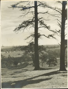
Photograph - Golf course viewed from East Kew, 1940s?
... Kew (Vic.)...Latrobe Golf Course...Undated but possibly 1930s. Kew (Vic.) Latrobe Golf Course Inscribed reverse: "M Holmes" View of Latrobe Course from the Kew side of the River Yarra. ...Landscape photograph of Kew and Fairfield. Undated but possibly 1930s.View of Latrobe Course from the Kew side of the River Yarra. River in middle foreground. Aged pine tree central foreground. Inscribed reverse: "M Holmes"kew (vic.), latrobe golf course -
Kew Historical Society Inc
Journal, The Kewriosity Sheet Vol.2 No.3 : August 1980
... kew (vic.) the kewriosity sheet newsletters - kew (vic.) What's doing in Kew for August / p1. Kew Historical Society [George Allan WW2 memorial; Kew Library] / Mavis Rolley p1. St Anne's School - East Kew [50th anniversary of laying of foundation stone] / p1. Epilepsy month / p1. Studley Park Progress Association [Yarra River, Environmental conservation] / Marshall Slattery p2. Greenacres Golf ...What's doing in Kew for August / p1. Kew Historical Society [George Allan WW2 memorial; Kew Library] / Mavis Rolley p1. St Anne's School - East Kew [50th anniversary of laying of foundation stone] / p1. Epilepsy month / p1. Studley Park Progress Association [Yarra River, Environmental conservation] / Marshall Slattery p2. Greenacres Golf Club / p1. St Hilary's Youth Club / p1. Kintore Social Club / p2. Early landmark of Kew [Kew Court House; Kew Post Office] / Elizabeth Mackie p2. Kew Garden Club / p2. Bowling Club nears century [Kew Bowling Club] / p2.Council News [Kindergarten enrolments; Funds available for local groups; Promoting Kew; Entertainment in Parks; What is R.A.A.V? (Rheumatism and Arthritis Association of Victoria)] / p2. Where have all the people gone? / Rev Stan Simmons p2. Scrabble [Kew Scrabble Club] / p2. Kew & Hawthorn Citizens' Advice Bureau / p2.The Kewriosity Sheet (1979-83) was first published in the City of Kew (Victoria) in June 1979 as a two-sided 'community newssheet'. It aimed to: 'share news about Kew happenings and Kew people, and to exchange ideas about living in Kew'. Later issues gradually evolved into a 4-page, quarto sized publication. The Kewriosity Sheet was superseded by the Kew Council publication 'Kewriosity' (1983-1994).non-fictionWhat's doing in Kew for August / p1. Kew Historical Society [George Allan WW2 memorial; Kew Library] / Mavis Rolley p1. St Anne's School - East Kew [50th anniversary of laying of foundation stone] / p1. Epilepsy month / p1. Studley Park Progress Association [Yarra River, Environmental conservation] / Marshall Slattery p2. Greenacres Golf Club / p1. St Hilary's Youth Club / p1. Kintore Social Club / p2. Early landmark of Kew [Kew Court House; Kew Post Office] / Elizabeth Mackie p2. Kew Garden Club / p2. Bowling Club nears century [Kew Bowling Club] / p2.Council News [Kindergarten enrolments; Funds available for local groups; Promoting Kew; Entertainment in Parks; What is R.A.A.V? (Rheumatism and Arthritis Association of Victoria)] / p2. Where have all the people gone? / Rev Stan Simmons p2. Scrabble [Kew Scrabble Club] / p2. Kew & Hawthorn Citizens' Advice Bureau / p2. community publications --- kew (vic.), the kewriosity sheet, newsletters - kew (vic.) -
Kew Historical Society Inc
Journal, The Kewriosity Sheet Vol.2 No.4 : September 1980
... kew (vic.) the kewriosity sheet newsletters - kew (vic.) What's doing in Kew for September / p1. Paul Craven to open [Kew] Festival / p1. Kew Croquet Club / p1. St Peter Claver Annual Mission Spring Fair / p1. Films [Kew High School Theatre / p1. Kew High School Art & Craft Market / p1. Games afternoons for secondary aged students / p1. Leadlight for beginners / p2. Greenacres Golf ...What's doing in Kew for September / p1. Paul Craven to open [Kew] Festival / p1. Kew Croquet Club / p1. St Peter Claver Annual Mission Spring Fair / p1. Films [Kew High School Theatre / p1. Kew High School Art & Craft Market / p1. Games afternoons for secondary aged students / p1. Leadlight for beginners / p2. Greenacres Golf results / p2. R.A.A.V. events in Kew / p2. Kew Philharmonic Society / p2. Kewriosity Sheet goes international! / p2. The Copy Shop / Elizabeth Mackie p2. North Kew Contact Scheme / p2. Toddler play groups / p2. Kew Traffic School / p2. Council News [New Mayor - Cr Peter Wallinga; Councillors retire - Cr Jack Ryan, Cr Jack Gervasoni, Cr Walter Haldun; Councillors re-elected - Cr Phyllis Hore, Cr Pritchard; New Councillors - Cr Jill O'Brien, Cr Roman McCausland; Extraordinary election - Prospect Ward; School Holiday Programme; Playcentre; Mobile New Games Centre] / p2.The Kewriosity Sheet (1979-83) was first published in the City of Kew (Victoria) in June 1979 as a two-sided 'community newssheet'. It aimed to: 'share news about Kew happenings and Kew people, and to exchange ideas about living in Kew'. Later issues gradually evolved into a 4-page, quarto sized publication. The Kewriosity Sheet was superseded by the Kew Council publication 'Kewriosity' (1983-1994).non-fictionWhat's doing in Kew for September / p1. Paul Craven to open [Kew] Festival / p1. Kew Croquet Club / p1. St Peter Claver Annual Mission Spring Fair / p1. Films [Kew High School Theatre / p1. Kew High School Art & Craft Market / p1. Games afternoons for secondary aged students / p1. Leadlight for beginners / p2. Greenacres Golf results / p2. R.A.A.V. events in Kew / p2. Kew Philharmonic Society / p2. Kewriosity Sheet goes international! / p2. The Copy Shop / Elizabeth Mackie p2. North Kew Contact Scheme / p2. Toddler play groups / p2. Kew Traffic School / p2. Council News [New Mayor - Cr Peter Wallinga; Councillors retire - Cr Jack Ryan, Cr Jack Gervasoni, Cr Walter Haldun; Councillors re-elected - Cr Phyllis Hore, Cr Pritchard; New Councillors - Cr Jill O'Brien, Cr Roman McCausland; Extraordinary election - Prospect Ward; School Holiday Programme; Playcentre; Mobile New Games Centre] / p2. community publications --- kew (vic.), the kewriosity sheet, newsletters - kew (vic.) -
Kew Historical Society Inc
Booklet - Old Kew Golf Links Estate, 1926
... Kew Golf Links Estate...Subdivision -- Kew (Vic.)...Old Kew Golf Links Estate Subdivision -- Kew (Vic.) Subdivisions -- Kew East (Vic) Chipperfield's Boathouse Kew East primary School Kew Golf Club 8-page brochure advertising 80 residential home sites for sale in a subdivision called the 'Old Kew Golf Links Estate'. ...Subdivision plans and real estate flyers/brochures reveal a number of aspects of urban development and history. The Kew Historical Society's collection of these plans, as well as advertisements extracted from magazines, cover key aspects of community development and architectural history of Kew and Kew Eat as well as surrounding suburbs. While most of the plans in the collection were gifted to the Society by the former City of Kew, a number of other plans and advertisements have been donated by individuals, of which this is an example.8-page brochure advertising 80 residential home sites for sale in a subdivision called the 'Old Kew Golf Links Estate'. These sites had historic importance in Kew's history as they had previously belonged to Kodak Pty Ltd who were refused permission by Kew Council to use the land for industrial development. The estate, advertised was advertised as being within five miles of Melbourne. The brochure is notable as it includes photographs of Kew East Primary School, the former Kew Golf Club clubhouse, and 'The Moorings' Boathouse (aka Chipperfield's Boat House). The aerial photograph, overlaid with names of notable sites, on the final page is of interest as it shows the area before the intrusion of the Eastern Freeway, which resulted in changing the course of a section of the Yarra River. old kew golf links estate, subdivision -- kew (vic.), subdivisions -- kew east (vic), chipperfield's boathouse, kew east primary school, kew golf club -
Kew Historical Society Inc
Plan - Willsmere Park Estate, Kew, 1926
... Kew (Vic.) subdivisions - kew (Vic.) subdivisions -- kew east (Vic.) willsmere park -- Kew East (Vic.) Original 4-page, bifold subdivision plan of the Willsmere Park Estate, Kew. The 1926 land sale advertised '40 superb villa allotments' on the 'Yarra Heights'. Streets within the subdivision included: Willow Grove, Kilby Road, Elm Grove and Belford Road. The double page spread on pages 2 and 3 shows the detailed plan of the 40 lots, surrounded by public parkland [Willsmere Park] and the Kew Golf ...Subdivision plans and real estate flyers/brochures reveal a number of aspects of urban development and history. The Kew Historical Society's collection of these plans, as well as advertisements extracted from magazines, cover key aspects of community development and architectural history of Kew and Kew Eat as well as surrounding suburbs. While most of the plans in the collection were gifted to the Society by the former City of Kew, a number of other plans and advertisements have been donated by individuals, of which this is an example.Original 4-page, bifold subdivision plan of the Willsmere Park Estate, Kew. The 1926 land sale advertised '40 superb villa allotments' on the 'Yarra Heights'. Streets within the subdivision included: Willow Grove, Kilby Road, Elm Grove and Belford Road. The double page spread on pages 2 and 3 shows the detailed plan of the 40 lots, surrounded by public parkland [Willsmere Park] and the Kew Golf Links. By the time that this version of the plan was released, only the lots on Willow Grove and Kilby Road remained. willsmere park estate -- kew (vic.), subdivisions - kew (vic.), subdivisions -- kew east (vic.), willsmere park -- kew east (vic.) -
Kew Historical Society Inc
Booklet - Yarraleen Estate, Bulleen, c.1966
... Kew, a number of other plans and advertisements have been donated by individuals, of which this is an example. Subdivisions -- Bulleen (Vic.) Yarraleen estate Original 8-page booklet advertising a new residential development in Bulleen entitled 'Yarraleen'. The glossy multi-colour brochure includes historic and contemporary photographs of the Yarra Valley, graphic designs of potential residential development, photographs of key facilities (Marcellin College, Golf links, local swimming holes, the Beaver Swim School, Carey Grammar School Oval and grandstand, shopping strips, and farmland). ...Subdivision plans and real estate flyers/brochures reveal a number of aspects of urban development and history. The Kew Historical Society's collection of these plans, as well as advertisements extracted from magazines, cover key aspects of community development and architectural history of Kew and Kew Eat as well as surrounding suburbs. While most of the plans in the collection were gifted to the Society by the former City of Kew, a number of other plans and advertisements have been donated by individuals, of which this is an example.Original 8-page booklet advertising a new residential development in Bulleen entitled 'Yarraleen'. The glossy multi-colour brochure includes historic and contemporary photographs of the Yarra Valley, graphic designs of potential residential development, photographs of key facilities (Marcellin College, Golf links, local swimming holes, the Beaver Swim School, Carey Grammar School Oval and grandstand, shopping strips, and farmland).subdivisions -- bulleen (vic.), yarraleen estate -
Kew Historical Society Inc
Plan - 30 Choice Home Sites in Kilby Road, Meldrum Street and Fairway Drive, 1965
... Kew East (Vic.)...Subdivisions -- Kew (Vic.)...Kew Golf...Subdivisions -- Kew East (Vic.) Subdivisions -- Kew (Vic.) Kew Golf Club Original 4-page, bifold brochure, one of two in the collection, of home sites created following the creation of the Eastern Freeway which separated a section of land owned by the Kew Golf Club from the main course. ...Subdivision plans and real estate flyers/brochures reveal a number of aspects of urban development and history. The Kew Historical Society's collection of these plans, as well as advertisements extracted from magazines, cover key aspects of community development and architectural history of Kew and Kew Eat as well as surrounding suburbs. While most of the plans in the collection were gifted to the Society by the former City of Kew, a number of other plans and advertisements have been donated by individuals, of which this is an example.Original 4-page, bifold brochure, one of two in the collection, of home sites created following the creation of the Eastern Freeway which separated a section of land owned by the Kew Golf Club from the main course. The new estate featured 30 lots in Meldrum Street, Kilby Road and Fairway Drive. subdivisions -- kew east (vic.), subdivisions -- kew (vic.), kew golf club -
Kew Historical Society Inc
Plan - 30 Choice Home Sites in Kilby Road, Meldrum Street and Fairway Drive, 1965
... kew east (vic.)...subdivisions -- kew (vic.)...kew golf...While most of the plans in the collection were gifted to the Society by the former City of Kew, a number of other plans and advertisements have been donated by individuals, of which this is an example. subdivisions -- kew east (vic.) subdivisions -- kew (vic.) kew golf club Original 4-page, bifold brochure, one of two in the collection, of home sites created following the creation of the Eastern Freeway which separated a section of land owned by the Kew Golf Club from the main course. ...Subdivision plans and real estate flyers/brochures reveal a number of aspects of urban development and history. The Kew Historical Society's collection of these plans, as well as advertisements extracted from magazines, cover key aspects of community development and architectural history of Kew and Kew Eat as well as surrounding suburbs. While most of the plans in the collection were gifted to the Society by the former City of Kew, a number of other plans and advertisements have been donated by individuals, of which this is an example.Original 4-page, bifold brochure, one of two in the collection, of home sites created following the creation of the Eastern Freeway which separated a section of land owned by the Kew Golf Club from the main course. The new estate featured 30 lots in Meldrum Street, Kilby Road and Fairway Drive.subdivisions -- kew east (vic.), subdivisions -- kew (vic.), kew golf club -
 Kew Historical Society Inc
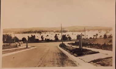
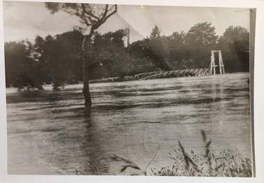
Photograph - Yarra Valley Floods: Kew East, 1916
... kilby road -- kew (vic.)...kew golf...Kew was devoted to dairy farming. In the twentieth century, before and after the construction of the Eastern Freeway, much of this low-lying area was used as golf courses and public parks. One of a collection of photographs of flooding in the Kew section of the Yarra Valley which are in important research resource for the location and extent of flooding in the first half of the twentieth century. yarra river yarra valley floods -- kew kilby road -- kew (vic.) kew golf club Verso: "Floods along Kilby Road / near Birdwood St? ...Flooding of the Yarra Valley, including that section of the Yarra bordering Kew and Kew East in the north and west of the municipality, was a regular occurrence. Extreme flood events of the Yarra River are recorded to have occurred in 1891, 1901, 1916, 1923 and 1934. The Municipality of Kew's response to these floods was to enact planning decisions restricting residential development in flood prone areas following the floods of 1916, 1921 and 1934. While floods continued after the development of the Upper Yarra Reservoir (construction 1948-57), the regularity and extent of these inundations diminished. During the nineteenth century, the land abutting the south side of the Yarra in Kew was devoted to dairy farming. In the twentieth century, before and after the construction of the Eastern Freeway, much of this low-lying area was used as golf courses and public parks.One of a collection of photographs of flooding in the Kew section of the Yarra Valley which are in important research resource for the location and extent of flooding in the first half of the twentieth century. Flooding of the Yarra Valley at East Kew in 1916. The view is taken from the intersection of Kilby Road with what is believed to be Birdwood Street, looking across the flood waters to Ivanhoe. The extensive flooded area shown in the photograph would have included the Kew Golf Club. Verso: "Floods along Kilby Road / near Birdwood St? & Kilby Road / 1917? / 87yarra river, yarra valley, floods -- kew, kilby road -- kew (vic.), kew golf club -
 Kew Historical Society Inc
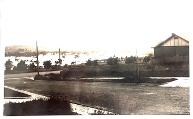
Photograph - Yarra Valley Floods: Kew East, 1916
... kilby road -- kew (vic.)...kew golf...Kew was devoted to dairy farming. In the twentieth century, before and after the construction of the Eastern Freeway, much of this low-lying area was used as golf courses and public parks. One of a collection of photographs of flooding in the Kew section of the Yarra Valley which are in important research resource for the location and extent of flooding in the first half of the twentieth century. yarra river yarra valley floods -- kew kilby road -- kew (vic.) kew golf club Verso: "Floods / Yarra River / East Kew / Kilby Road / 1917? ...Flooding of the Yarra Valley, including that section of the Yarra bordering Kew and Kew East in the north and west of the municipality, was a regular occurrence. Extreme flood events of the Yarra River are recorded to have occurred in 1891, 1901, 1916, 1923 and 1934. The Municipality of Kew's response to these floods was to enact planning decisions restricting residential development in flood prone areas following the floods of 1916, 1921 and 1934. While floods continued after the development of the Upper Yarra Reservoir (construction 1948-57), the regularity and extent of these inundations diminished. During the nineteenth century, the land abutting the south side of the Yarra in Kew was devoted to dairy farming. In the twentieth century, before and after the construction of the Eastern Freeway, much of this low-lying area was used as golf courses and public parks.One of a collection of photographs of flooding in the Kew section of the Yarra Valley which are in important research resource for the location and extent of flooding in the first half of the twentieth century. Flooding of the Yarra Valley at East Kew in 1916. The view is taken from a street (maybe Birdwood Avenue) intersecting with Kilby Road looking northeast across the flood waters to Ivanhoe and Heidelberg. The extensive flooded area shown in the photograph would have included remnant dairy farms and the Kew Golf Club. Verso: "Floods / Yarra River / East Kew / Kilby Road / 1917? / 87"yarra river, yarra valley, floods -- kew, kilby road -- kew (vic.), kew golf club -
 Kew Historical Society Inc
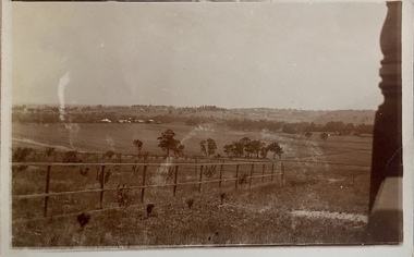
Photograph - Yarra Valley at Kew, 1912
... Kew was devoted to dairy farming. In the twentieth century, before and after the construction of the Eastern Freeway, much of this low-lying area was used as golf courses and public parks. yarra river yarra valley farming -- kew (vic.) ...During the nineteenth century, the land abutting the south side of the Yarra in Kew was devoted to dairy farming. In the twentieth century, before and after the construction of the Eastern Freeway, much of this low-lying area was used as golf courses and public parks.Real-photo postcard of the farmland in the Yarra Valley in what is believed to be North Kew in 1912. Verso: "Willsmere / East Kew / 1912"yarra river, yarra valley, farming -- kew (vic.) -
 Kew Historical Society Inc
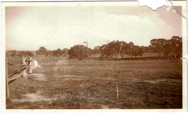
Photograph - Yarra Flats near Burke Road Bridge, 1937
... Kew is now either designated open space, parkland or public golf links. By the 1930s much of this area remained open farmland, bought at auction for dairy farming in the 1840s. studley park -- kew (vic.) ...Land along the Yarra River in Kew is now either designated open space, parkland or public golf links. By the 1930s much of this area remained open farmland, bought at auction for dairy farming in the 1840s.Original, black and white positive print of what is said to be the Yarra Flats near Burke Road Bridge. On the horizon, building can be seen, whereas in the middle ground, farm fencing and a windmill are the main features as well as remnant Eucalypts. Inscribed verso: "Yarra Flats near Burke Rd Bridge 1937" studley park -- kew (vic.) -
 Kew Historical Society Inc
Photograph - Kane's Bridge on the Yarra River, December 1934
... Kew with the public golf course across the Yarra. The total cost of construction came to 250 pounds and the bridge became known as Kane's Bridge. During the 1934 floods the bridge was washed downstream, and was subsequently rebuilt. The present form of the bridge resembles the earlier bridge which crossed from the Yarra Bend Asylum to Kew, further upstream. (VHD) river yarra yarra -- kew (vic ...In 1928 a footbridge was erected to link Kew with the public golf course across the Yarra. The total cost of construction came to 250 pounds and the bridge became known as Kane's Bridge. During the 1934 floods the bridge was washed downstream, and was subsequently rebuilt. The present form of the bridge resembles the earlier bridge which crossed from the Yarra Bend Asylum to Kew, further upstream. (VHD)Original, black and white positive of Kane's Bridge in December 1934, when the 'great flood' of the Yarra caused the bridge's destruction. Inscribed verso: "Kane's Bridge Yarra in flood Dec 1934"river yarra, yarra -- kew (vic.), kanes bridge, 1934 floods -
 Kew Historical Society Inc
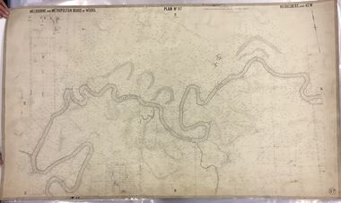
Map, MMBW, MMBW Plan No.117 Heidelberg & Kew, 1900-1910
... kew (vic.) -- maps heidelberg (vic.) -- maps MELBOURNE AND METROPOLITAN BOARD OF WORKS / PLAN NO. 117 / HEIDELBERG & KEW Early map of part of the Borough of Kew, created in the early twentieth century, at a scale 160 ft to 1 inch. The map covers what was then the north eastern part of Kew showing the natural landscape and limited development on the south side of the Yarra River. In the Kew section, south of the river, the land is occupied currently by the Greenacres and Kew Golf ...The Melbourne and Metropolitan Board of Works (MMBW) was established by an act of the Victorian Parliament in 1890 to prepare for and to implement a sewerage and water reticulation system across what was then inner Melbourne, its surrounding and middle distance suburbs, including Kew. The MMBW was disbanded in 1991.The map collection of the Kew Historical Society has at its core the historic maps assembled and originally stored in the City Engineer's Department of the City of Kew. These include maps in a number of scales. The vast majority of maps were produced by the MMBW in the first two decades of the twentieth century, and are solid working maps, backed by linen for durability. These maps are historically significant to Kew, the City of Boroondara and to the history of the development of state utilities in Victoria. A number of the Kew maps have additional details added by former municipal officers, including the levels reached by various floods. As these were working documents, information was added to them long after the period of their initial production and distribution.Early map of part of the Borough of Kew, created in the early twentieth century, at a scale 160 ft to 1 inch. The map covers what was then the north eastern part of Kew showing the natural landscape and limited development on the south side of the Yarra River. In the Kew section, south of the river, the land is occupied currently by the Greenacres and Kew Golf Clubs. The map shows the extent of urban development by that time and the outlines of the few built structures in the municipality. The height above sea level of all parts of the landscape are indicated numerically in feet. Contour lines and the levels of historic floods were added in ink to the map at a later stage. MELBOURNE AND METROPOLITAN BOARD OF WORKS / PLAN NO. 117 / HEIDELBERG & KEW melbourne & metropolitan board of works, mmbw maps, borough of kew, cartography, mmbw plan no. 117, kew (vic.) -- maps, heidelberg (vic.) -- maps -
 Kew Historical Society Inc
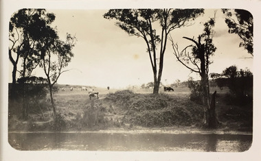
Photograph - Yarra River, Kew, 1925
... kew (vic.) — yarra river christian-washfold collection photograph albums dairying -- kew (vic.) "Yarra Rvr / Kew / 1925" Digital copy of a photograph from page 3 of the 47-page photograph album containing 261 gelatinous silver images, loaned by Diane Washfold with permission given to digitise and hold a copy in our collection. A photograph of a stretch of the Yarra River at Kew. From the 1840s, at the Crown Land Sales, lots adjacent to the river were sold and developed as dairy farms, hence the presence of cattle until the land was subdivided or created into golf ...Henry Beater Christian (1886-1962) , was a descendant of one of the earliest settler families in Kew. Employed at the Kew Asylum as a 'public servant', he was a skilled amateur photographer, photographing numerous scenes in Kew and on his travels around Victoria. The majority of his photographs date from 1916 to 1929. His finest photographs are housed in two photograph albums. Digital copy of a photograph from page 3 of the 47-page photograph album containing 261 gelatinous silver images, loaned by Diane Washfold with permission given to digitise and hold a copy in our collection. A photograph of a stretch of the Yarra River at Kew. From the 1840s, at the Crown Land Sales, lots adjacent to the river were sold and developed as dairy farms, hence the presence of cattle until the land was subdivided or created into golf courses during the twentieth century. "Yarra Rvr / Kew / 1925"henry beater christian (1886-1962), landscape photography, kew (vic.) — yarra river, christian-washfold collection, photograph albums, dairying -- kew (vic.)