Showing 5 items matching "gorrockburkchap parish maps"
-
 Bacchus Marsh & District Historical Society
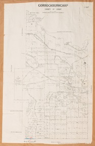
Map, Gorrockburkchap Parish Map, County of Grant
... Gorrockburkchap Parish Map, County of Grant...Gorrockburkchap Parish Maps...A single page paper map showing the parish plan for Gorrockburkchap in the County of Grant. ...High resolution digital image stored on BMDHS computer network. Gorrockburkchap Parish Map, County of Grant Map Shire of Bacchus Marsh ...The parish of Gorrockburkchap (sometimes spelled Gorrockburkghap) lies to the west and south west of the township of Bacchus Marsh. The locality of Rowsley is situated within this parish area.A single page paper map showing the parish plan for Gorrockburkchap in the County of Grant. The map is pasted into a bound volume containing 76 maps or plans in total. High resolution digital image stored on BMDHS computer network. gorrockburkchap parish maps, rowsley victoria maps -
 Bacchus Marsh & District Historical Society
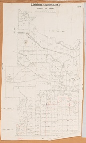
Map, Gorrockburkchap Parish Map, County of Grant c.1915
... Gorrockburkchap Parish Map, County of Grant c.1915...Gorrockburkchap Parish Maps...A single page paper map showing the parish plan for Gorrockburkchap in the County of Grant. ...High resolution digital image stored on BMDHS computer network. Gorrockburkchap Parish Map, County of Grant c.1915 Map Shire of Bacchus Marsh ...The parish of Gorrockburkchap (sometimes spelled Gorrockburkghap) lies to the west and south west of the township of Bacchus Marsh. The locality of Rowsley is situated within this parish area.A single page paper map showing the parish plan for Gorrockburkchap in the County of Grant. The map is pasted into a bound volume containing 76 maps or plans in total. High resolution digital image stored on BMDHS computer network. gorrockburkchap parish maps, rowsley victoria maps -
 Bacchus Marsh & District Historical Society
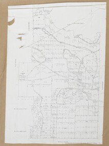
Map, Gorrockburkchap Parish Map, County of Grant c.1906
... Gorrockburkchap Parish Map, County of Grant c.1906...Gorrockburkchap Parish Maps...A single page paper map showing the parish plan for Gorrockburkchap in the County of Grant. ... Rowsley Victoria Maps Bacchus Marsh Region Parish Plans A single page paper map showing the parish plan for Gorrockburkchap in the County of Grant. ...The parish of Gorrockburkchap (sometimes spelled Gorrockburkghap) lies to the west and south west of the township of Bacchus Marsh. The locality of Rowsley is situated within this parish area.A single page paper map showing the parish plan for Gorrockburkchap in the County of Grant. A cadastral map showing parish boundaries and land ownership The map is pasted into a bound volume containing 76 maps or plans in total. High resolution digital image stored on BMDHS computer network. gorrockburkchap parish maps, rowsley victoria maps, bacchus marsh region parish plans -
 Bacchus Marsh & District Historical Society
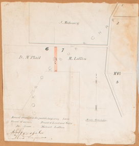
Map, Land required for a public highway near Rowsley, Victoria. Circa 1880s
... This map indicates portions of land in the Parish of Gorrockburkchap near Rowsley which was required for construction of a road. ...Bacchus Marsh & District Historical Society Lerderderg Library Main Street Bacchus Marsh This map indicates portions of land in the Parish of Gorrockburkchap near Rowsley which was required for construction of a road. ...This map indicates portions of land in the Parish of Gorrockburkchap near Rowsley which was required for construction of a road. The land required was leased to a Michael Laffan. Other blocks of land nearby owned or leased by D. McPhail and J. Mahoney are also indicated on the map. The date of the map is not known. However newspaper reports in the Bacchus Marsh Express on the 18 March 1882, page 3, column 3 mention land occupied by McPhail and Laffan near Rowsley in connection to the construction of a public road.Single page map showing land occupied by farmers D. McPhail and Michael Laffan which was required for a public highway. Scale 6 chains to inch. Part of a set of maps which are pasted into a bound volume containing 76 maps or plans in total. High resolution digital image stored on BMDHS computer network. Signed by Shire Engineer, W.E. Standfieldrowsley victoria maps -
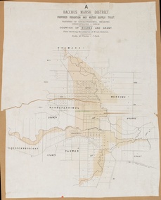 Bacchus Marsh & District Historical Society
Map, Bacchus Marsh District (A). Proposed Irrigation and Water Supply Trust. Plan shewing boundaries of Trust District
... map of the proposed Bacchus Marsh Irrigation and Water Supply district. Circa 1889. Plan showing boundaries of Trust District. The District lies within the Parishes of Korkuperrimul, Merrimu, Parwan and Gorrockburkchap in the Counties of Bourke and Grant. ...map of the proposed Bacchus Marsh Irrigation and Water Supply district. Circa 1889. Plan showing boundaries of Trust District. The District lies within the Parishes of Korkuperrimul, Merrimu, Parwan and Gorrockburkchap in the Counties of Bourke and Grant. ...The 1886 Irrigation Act in Victoria introduced the first legislation in Australia designed to enable the creation of a detailed scheme for agricultural irrigation. Part of the legislation saw the use of government funds for local irrigation projects. These local projects were managed by local irrigation trusts. The Bacchus Marsh Irrigation and Water Supply Trust was formed in 1889. This map depicts the proposed area of the Trust.Printed paper map of the proposed Bacchus Marsh Irrigation and Water Supply district. Circa 1889. Plan showing boundaries of Trust District. The District lies within the Parishes of Korkuperrimul, Merrimu, Parwan and Gorrockburkchap in the Counties of Bourke and Grant. At the top of the map above its title is the letter 'A; in capital lettering. Scale: 40 Chains = 1 inch.irrigation, water supply, bacchus marsh irrigation and water supply trust