Showing 4 items matching "grass damage from trees"
-
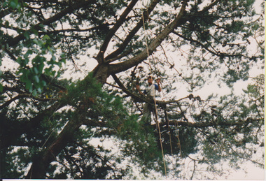 University of Melbourne, Burnley Campus Archives
Photograph - Colour print, Kodak, Arboriculture, Unknown
... tree climbing...shady walk...araucaria bidwillii...grass damage from...University of Melbourne, Burnley Campus Archives 500 Yarra Boulevard Richmond melbourne students tree climbing shady walk araucaria bidwillii grass damage from trees arboriculture Colour photographs. (1) A student climbing a conifer. (2) The Araucaria bidwillii that the students used to learn to climb in the Shady Walk. (3-5) Patchy grass under trees. ...Colour photographs. (1) A student climbing a conifer. (2) The Araucaria bidwillii that the students used to learn to climb in the Shady Walk. (3-5) Patchy grass under trees.students, tree climbing, shady walk, araucaria bidwillii, grass damage from trees, arboriculture -
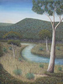 Bayside Gallery - Bayside City Council Art & Heritage Collection
Painting - oil and acrylic on canvas, Robert Kelly, Chinaman's Creek, 2016
... from Wonga (Arthur’s Seat) down through Tootgarook Swamp into Port Phillip Bay. It was a great fresh water and food source and home for many Boonwurrung people. Since settlement over 170 years ago, the creek has been drained, blocked, reconstructed and damaged. Kelly depicts a lush green landscape in which the clean creek water winds through the surrounding vegetation of spinifex grasses and gum trees...from Wonga (Arthur’s Seat) down through Tootgarook Swamp into Port Phillip Bay. It was a great fresh water and food source and home for many Boonwurrung people. Since settlement over 170 years ago, the creek has been drained, blocked, reconstructed and damaged. Kelly depicts a lush green landscape in which the clean creek water winds through the surrounding vegetation of spinifex grasses and gum trees ...Bob Kelly paints landscapes of culturally significant sites along the Mornington Peninsula and depicts these locations as he imagines they originally were before colonisation. Using traditional Western painting techniques, Kelly records the underlying spirit of the Peninsula from a Wathaurong perspective. Chinaman’s Creek in Capel Sound (Rosebud West) was an important watercourse that originally ran from Wonga (Arthur’s Seat) down through Tootgarook Swamp into Port Phillip Bay. It was a great fresh water and food source and home for many Boonwurrung people. Since settlement over 170 years ago, the creek has been drained, blocked, reconstructed and damaged. Kelly depicts a lush green landscape in which the clean creek water winds through the surrounding vegetation of spinifex grasses and gum trees, the background hills are abundant with trees, untouched from man's intervention. Using painstaking detail, Kelly records each blade of grass and ripple on the surface of Chinaman’s Creek. His attention to detail serves to powerfully reimagine this important cultural site, returning it to its former pristine state, and reinvigorating its role as a key place of sustenance for the Indigenous populations of the Peninsula. Chinaman's Creek was a finalist in the 2017 Bayside Acquisitive Art Prize.oil and acrylic on canvaslandscape, creek, trees, chinaman's creek, painting, indigenous, robert kelly, bayside acquisitive art prize, bob kelly, wathaurong, rosebud, arthur's seat, tootgarook swamp, port phillip bay, boonwurrung -
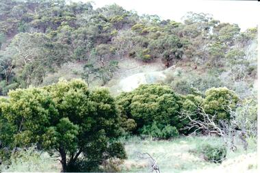 Hume City Civic Collection
Photograph, Early 1990's
... damage caused by erosion, vegetation growth and vandalism. The adit and mullock heap is from one of the mines on Redstone Hill. It was known as Batey's Mine. stone structures batey's mine gold mining redstone hill george evans collection A coloured photograph of the remains of a mullock heap and adit from a mine. The entrance is surrounded by low growing trees and grass ...This is a photograph of one of the many stone ruins which can be seen in the Sunbury area and surrounding districts. These ruins are found in varying degrees of structural damage caused by erosion, vegetation growth and vandalism. The adit and mullock heap is from one of the mines on Redstone Hill. It was known as Batey's Mine.A coloured photograph of the remains of a mullock heap and adit from a mine. The entrance is surrounded by low growing trees and grass.stone structures, batey's mine, gold mining, redstone hill, george evans collection -
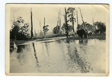 Orbost & District Historical Society
Photograph - Flood at Bete Bolong, c.1900-1930s
... From the earliest days of 'white' settlement (1870s), floods were a fact of life, both a blessing and a liability, often causing severe damage. This photograph is significant because it is shows the Snowy River in flood at Bete Bolong. Snowy River Bete Bolong floods On the back of the photo, handwritten in black ink: 'River in flood, horses on last bit of grass, Bete Bolong'. A small b/w photograph showing a river in flood with a number of horses on the right hand side, some are wearing coats. In the background is a crop (possibly maize) and trees ...This is one of many photographs taken throughout the 20th century of the Snowy River in flood. Although the township of Orbost was built above the floodplain, much of the really fertile farming land is flood liable. From the earliest days of 'white' settlement (1870s), floods were a fact of life, both a blessing and a liability, often causing severe damage.This photograph is significant because it is shows the Snowy River in flood at Bete Bolong. A small b/w photograph showing a river in flood with a number of horses on the right hand side, some are wearing coats. In the background is a crop (possibly maize) and trees both alive and dead.On the back of the photo, handwritten in black ink: 'River in flood, horses on last bit of grass, Bete Bolong'.snowy river, bete bolong, floods