Showing 173 items matching "great divide"
-
 Marysville & District Historical Society
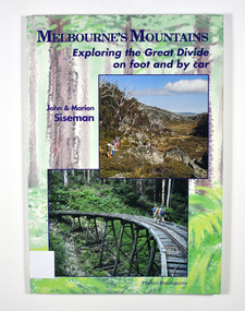
Book - Paperback book, Melbourne's Mountains-Exploring the Great Divide on foot and by car, 1993
... Melbourne's Mountains-Exploring the Great Divide on foot and by car...great divide...Exploring the Great Divide on foot and by car...Marysville & District Historical Society 39 Darwin Street Marysville yarra-valley-and-the-dandenong-ranges Exploring the Great Divide on foot and by car great divide walking touring mountains victoria tourism siseman, john siseman, marion Stamp of Marysville & District / Historical Society Inc / P.O. ...Exploring the Great Divide on foot and by carPaperback. Front and back covers have a painting of a forest as a background with photographs of mountains, an old trestle bridge and old machinery. Back cover also has a sinopsis of the book.Stamp of Marysville & District / Historical Society Inc / P.O. Box 22 / Marysville 3779great divide, walking, touring, mountains, victoria, tourism, siseman, john, siseman, marion -
 Marysville & District Historical Society
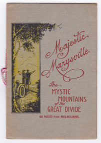
Booklet (Item) - Information booklet, Marysville Tourist Association, Majestic Marysville The Mystic Mountains of the Great Divide 62 Miles from Melbourne, Unknown
... Majestic Marysville The Mystic Mountains of the Great Divide 62 Miles from Melbourne......great divide...Majestic Marysville The Mystic Mountains of the Great Divide 62 Miles from Melbourne Booklet Information booklet Marysville Tourist Association ...An information booklet on various attractions in and around Marysville and the district which was produced by the Marysville Tourist Association. The Association was formed in November 1907 to promote tourism within the area. This included the physical creation of signage, parklands, roads and walks to various attractions. An information booklet on various attractions in and around Marysville and the district which was produced by the Marysville Tourist Association.FRANK ENDACOTT/ Healesvillemarysville, victoria, mystic mountains, great divide, steavenson falls, keppel falls, cameron cascades, cumberland, mt cathedral, triangle, eildon weir, snob's falls, wolfram mine, mt strickland, keppel's lookout, mt kitchener, mt edgar, oxlee's lookout, mt gordon, nichol's lookout, michael dene, beauty spot, gilbert's gully, taggerty river, buxton road -
 Marysville & District Historical Society
Article (Item) - Magazine article, Ann Friedel Publishing, It's bean a long journey, 2020
... ...great divide coffee...A magazine article on the Great Divide Coffee company in Marysville in Victoria....A magazine article on the Great Divide Coffee company in Marysville in Victoria. ...A magazine article on the Great Divide Coffee company in Marysville in Victoria. marysville victoria great divide coffee james fraga magazine article A magazine article on the Great Divide Coffee company in Marysville in Victoria. ...A magazine article on the Great Divide Coffee company in Marysville in Victoria.A magazine article on the Great Divide Coffee company in Marysville in Victoria.marysville, victoria, great divide coffee, james fraga, magazine article -
 Marysville & District Historical Society
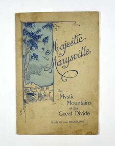
Booklet, Marysville Tourist Association, Magestic Marysville-The Mystic Mountains of the Great Divide, 1920's
... Magestic Marysville-The Mystic Mountains of the Great Divide...Magestic Marysville-The Mystic Mountains of the Great Divide Booklet Booklet Marysville Tourist Association ...An information guide of day trips to attractions in and around Marysville in Victoria. This booklet was produced by the Marysville Tourist Association.Paperback. Cover is beige with a drawing of two people standing next to a car looking at the view. The title is in dark blue across the front.non-fictionAn information guide of day trips to attractions in and around Marysville in Victoria. This booklet was produced by the Marysville Tourist Association.marysville, victoria, marysville tourise association, steavenson falls, keppel falls, cameron cascades, cumberland, mt cathedral, eildon, snob's creek falls, wolfram mine, mt strickland, keppel's lookout, mt kitchener, mt edgar, mt gordon, nichol's lookout, michael dene, beauty spot, gilbert's gully, taggerty river, wood's point -
 Marysville & District Historical Society
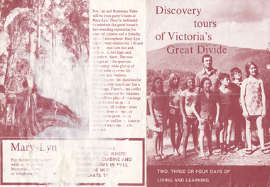
Ephemera (item) - Accommodation brochure, Discovery tours of Victoria's Great Divide, Unknown
... Discovery tours of Victoria's Great Divide...Discovery tours of Victoria's Great Divide Ephemera Accommodation brochure ...A brochure outlining the accommodation and facilities available to guests staying at Mary-Lyn Guest House in Marysville. Mary-Lyn was a part of the Mary Chain of guest houses built by Eric Dowdle during the Depression years.A brochure outlining the accommodation and facilities available to guests staying at Mary-Lyn Guest House in Marysville.marysville, victoria, australia, mary chain guest houses, mary-lyn guest house, eric dowdle, brochure, norman fiske, rosemary fiske -
National Vietnam Veterans Museum (NVVM)
Audio - Audio, CD, Muster on the Great Divide: Australian bush songs
... Muster on the Great Divide: Australian bush songs...National Vietnam Veterans Museum (NVVM) 25 Veterans Drive Newhaven phillip-island-and-the-bass-coast Popular music - Australia Battle of Long Tan Also includes the song, The Battle of Long Tan Muster on the Great Divide: Australian bush songs Audio Audio, CD Rodger, Graham ...Also includes the song, The Battle of Long Tanpopular music - australia, battle of long tan -
Whitehorse Historical Society Inc.
Article, The Great Divide, 2015
... The Great Divide...Blackburn traders complain of poorly planned pedestrian access across the railway line at Blackburn Station which will continue to divide the shopping precinct after the level crossing is upgraded The Great Divide Article Article ...Blackburn traders complain of poorly planned pedestrian access across the railway line at Blackburn Station.Blackburn traders complain of poorly planned pedestrian access across the railway line at Blackburn Station which will continue to divide the shopping precinct after the level crossing is upgradedBlackburn traders complain of poorly planned pedestrian access across the railway line at Blackburn Station.railway crossings, blackburn, blackburn shopping centre -
 Marysville & District Historical Society
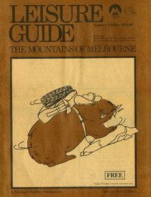
Magazine (Item) - Leisure guide, Michael Cheshire, LEISURE GUIDE THE MOUNTAINS OF MELBOURNE, 1984
... A leisure guide to the mountains of Melbourne beginning in the eastern suburbs, going through the Yarra Valley and into the Great Dividing Range. This was produced by Michael Cheshire as a free publication to promote Melbourne tourism. ...A leisure guide to the mountains of Melbourne beginning in the eastern suburbs, going through the Yarra Valley and into the Great Dividing Range....Marysville & District Historical Society 39 Darwin Street Marysville yarra-valley-and-the-dandenong-ranges A leisure guide to the mountains of Melbourne beginning in the eastern suburbs, going through the Yarra Valley and into the Great Dividing Range. This was produced by Michael Cheshire as a free publication to promote Melbourne tourism. ...A leisure guide to the mountains of Melbourne beginning in the eastern suburbs, going through the Yarra Valley and into the Great Dividing Range. This was produced by Michael Cheshire as a free publication to promote Melbourne tourism. The magazine featured Healesville, Marysville, Warburton, Eildon, Alexandra, the Upper Yarra area, and includes information on wineries in the district. It was released in the summer of 1984-1985.A leisure guide to the mountains of Melbourne beginning in the eastern suburbs, going through the Yarra Valley and into the Great Dividing Range.Summer Edition 1984-85 Featuring:/ Healesville, Marysville, Warburton, Eildon,/ Alexandra, Wineries and Upper Yarra Area.healesville, warburton, eildon, alexandra, upper yarra, marysville, victoria, australia, leisure guide, michael cheshire, blackwood holiday flats, black spur motel and caravan park, tudor lodge road house, nanda binya lodge, marysville caravan park, marysville recreation and fun park, scenic motel, the tower motel, the cumberland, cathedral restaurant, cathedral restaurant gallery, taggerty golf course, taggerty holiday units, marylyn guest house -
Lakes Entrance Historical Society
Map - Alpine Study Area - Topography, Land Conservation Council
... Map shows Great Dividing Range...Lakes Entrance Historical Society 4 Marine Parade Lakes Entrance gippsland Topography study Conservation Map No. 3 Map shows Great Dividing Range Map Alpine Study Area - Topography Land Conservation Council ...Map shows Great Dividing RangeMap No. 3topography, study, conservation -
Lakes Entrance Historical Society
Map - Alpine Study Area - Land Systems, Land Conservation Council
... Map shows land systems, bounderies in the Great Dividing Range...Lakes Entrance Historical Society 4 Marine Parade Lakes Entrance gippsland Topography Land Systems Conservation Map No. 7 Map shows land systems, bounderies in the Great Dividing Range Map Alpine Study Area - Land Systems Land Conservation Council ...Map shows land systems, bounderies in the Great Dividing RangeMap No. 7topography, land systems, conservation -
 Bendigo Historical Society Inc.
Document - LOCAL TREES - AND OTHERS
... ... Along the Great Divide...History House 11 Mackenzie Street Bendigo goldfields DOCUMENT Local Trees - and Others Australian Red Cedar Bill Beatty Along the Great Divide Typed notes mostly on the native cedar tree (Cedrela australia - Australian Red Cedar). ...Typed notes mostly on the native cedar tree (Cedrela australia - Australian Red Cedar). Notes describe the cedar as an attractive, easily worked timber that was plentiful. Most of the notes describes the loss of the trees by the timber cutters cutting the trees for furniture.document, local trees - and others, australian red cedar, bill beatty, along the great divide -
 Marysville & District Historical Society
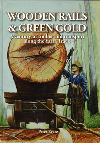
Book - Hardcover book, Peter Evans, Wooden Rails & Green Gold-A century of timber and transport along the Yarra Track, 2022
... ...great divide...Marysville & District Historical Society 39 Darwin Street Marysville yarra-valley-and-the-dandenong-ranges A history of the timber mills along the Yarra Track from Narbethong to Matlock A history of the timber mills along the Yarra Track from Narbethong to Matlock timber timber mills yarra track narbethong matlock marysville wood's point wilks creek great divide cathedral range cumberland foresters sawmillers peter evans A history of the timber mills along the Yarra Track from Narbethong to Matlock. ...A history of the timber mills along the Yarra Track from Narbethong to Matlock.Hardcover. Shows Mick Taylor making last-minute adjustments to the rigging of a large log about to commence its journey down the incline to the Marysville Timber and Seasoning Company No.1 mill. Back cover has a photograph of a rail tractor towing a timber trolley along a timber tramway.non-fictionA history of the timber mills along the Yarra Track from Narbethong to Matlock.timber, timber mills, yarra track, narbethong, matlock, marysville, wood's point, wilks creek, great divide, cathedral range, cumberland, foresters, sawmillers, peter evans -
 Marysville & District Historical Society
Book - Hardcover book, Peter Evans, Wooden Rails & Green Gold-A century of timber and transport along the Yarra Track, 2022
... ...great divide...A history of the timber mills along the Yarra Track from Narbethong to Matlock. timber timber mills yarra track narbethong matlock marysville wood's point wilks creek great divide cathedral range cumberland foresters sawmillers peter evans A history of the timber mills along the Yarra Track from Narbethong to Matlock. ...A history of the timber mills along the Yarra Track from Narbethong to Matlock.Hardcover. Shows Mick Taylor making last-minute adjustments to the rigging of a large log about to commence its journey down the incline to the Marysville Timber and Seasoning Company No.1 mill. Back cover has a photograph of a rail tractor towing a timber trolley along a timber tramway.non-fictionA history of the timber mills along the Yarra Track from Narbethong to Matlock.timber, timber mills, yarra track, narbethong, matlock, marysville, wood's point, wilks creek, great divide, cathedral range, cumberland, foresters, sawmillers, peter evans -
 Marysville & District Historical Society
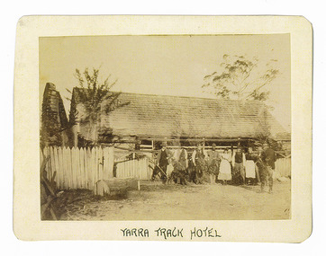
Photograph (Item) - Black and white photograph, Yarra Track Hotel, c1900
... ...great divide...A direct route via the Yarra River and the Great Divide was discovered by Rieck in September 1862 and became known as the Yarra Track. ...An early black and white photograph of a hotel along the Yarra Track.An early black and white photograph of a hotel along the Yarra Track. The Yarra Track is the former name of the gold fields road from Healesville to the Woods Point and Jordan Goldfields, in Victoria, Australia. A direct route via the Yarra River and the Great Divide was discovered by Rieck in September 1862 and became known as the Yarra Track. Early in 1863, the Victorian Government decided to construct a 193-kilometre (120 mile) road along the route. Its original width varied between 4 and 6 metres (12 and 20 feet), and was designed to accommodate horse-drawn vehicles. The Track involved the climbing of the Black Spur, descent into the Acheron Valley, and then through Marysville to the Cumberland where it followed the existing route. Unable to ascertain both the location and name of hotel.ARMSTRONG COLLECTION 42 STATION STREET/ SANDRINGHAM 3191/ TEL. (03) 9521 5442/ IAN M.L. ARMSTRONG OAMyarra track, healesville, wood's point, jordan goldfields, victoria, yarra river, great divide, reick, black spur, acheron valley, marysville, cumberland creek -
 Marysville & District Historical Society
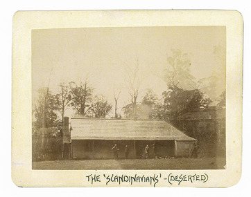
Photograph (Item) - Black and white photograph, The "Scandinavians' - (Deserted), c1900
... ...great divide...A direct route via the Yarra River and the Great Divide was discovered by Rieck in September 1862 and became known as the Yarra Track. ...An early black and white photograph of The Scandinavian's Hotel and Boarding House along the Yarra Track.An early black and white photograph of The Scandinavian's Hotel and Boarding House along the Yarra Track. The Yarra Track is the former name of the gold fields road from Healesville to the Woods Point and Jordan Goldfields, in Victoria, Australia. A direct route via the Yarra River and the Great Divide was discovered by Rieck in September 1862 and became known as the Yarra Track. Early in 1863, the Victorian Government decided to construct a 193-kilometre (120 mile) road along the route. Its original width varied between 4 and 6 metres (12 and 20 feet), and was designed to accommodate horse-drawn vehicles. The Track involved the climbing of the Black Spur, descent into the Acheron Valley, and then through Marysville to the Cumberland where it followed the existing route.ARMSTRONG COLLECTION 42 STATION STREET/ SANDRINGHAM 3191/ TEL. (03) 9521 5442/ IAN M.L. ARMSTRONG OAMthe scandinavians', yarra track, healesville, wood's point, jordan goldfields, victoria, yarra river, great divide, reick, black spur, acheron valley, marysville, cumberland creek -
 Marysville & District Historical Society
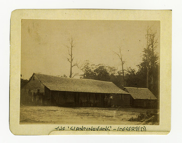
Photograph (Item) - Black and white photograph, The "Scandinavians' - (Deserted), c1900
... ...great divide...A direct route via the Yarra River and the Great Divide was discovered by Rieck in September 1862 and became known as the Yarra Track. ...An early black and white photograph of The Scandinavian's Hotel and Boarding House along the Yarra Track.An early black and white photograph of The Scandinavian's Hotel and Boarding House along the Yarra Track. The Yarra Track is the former name of the gold fields road from Healesville to the Woods Point and Jordan Goldfields, in Victoria, Australia. A direct route via the Yarra River and the Great Divide was discovered by Rieck in September 1862 and became known as the Yarra Track. Early in 1863, the Victorian Government decided to construct a 193-kilometre (120 mile) road along the route. Its original width varied between 4 and 6 metres (12 and 20 feet), and was designed to accommodate horse-drawn vehicles. The Track involved the climbing of the Black Spur, descent into the Acheron Valley, and then through Marysville to the Cumberland where it followed the existing route.ARMSTRONG COLLECTION 42 STATION STREET/ SANDRINGHAM 3191/ TEL. (03) 9521 5442/ IAN M.L. ARMSTRONG OAMthe scandinavians', yarra track, healesville, wood's point, jordan goldfields, victoria, yarra river, great divide, reick, black spur, acheron valley, marysville, cumberland creek -
 Marysville & District Historical Society
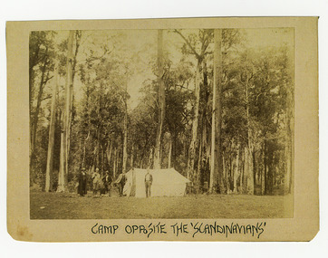
Photograph (Item) - Black and white photograph, Camp Opposite The "Scandinavians', c1900
... ...great divide...A direct route via the Yarra River and the Great Divide was discovered by Rieck in September 1862 and became known as the Yarra Track. ...An early black and white photograph of a camp which was opposite The Scandinavian's Hotel and Boarding House along the Yarra Track.An early black and white photograph of a camp which was opposite The Scandinavian's Hotel and Boarding House along the Yarra Track. The Yarra Track is the former name of the gold fields road from Healesville to the Woods Point and Jordan Goldfields, in Victoria, Australia. A direct route via the Yarra River and the Great Divide was discovered by Rieck in September 1862 and became known as the Yarra Track. Early in 1863, the Victorian Government decided to construct a 193-kilometre (120 mile) road along the route. Its original width varied between 4 and 6 metres (12 and 20 feet), and was designed to accommodate horse-drawn vehicles. The Track involved the climbing of the Black Spur, descent into the Acheron Valley, and then through Marysville to the Cumberland where it followed the existing route.ARMSTRONG COLLECTION 42 STATION STREET/ SANDRINGHAM 3191/ TEL. (03) 9521 5442/ IAN M.L. ARMSTRONG OAMthe scandinavians', yarra track, healesville, wood's point, jordan goldfields, victoria, yarra river, great divide, reick, black spur, acheron valley, marysville, cumberland creek -
Marysville & District Historical Society
THE TRIANGLE NEWS-VOL 41 NO 33-AUGUST 29 2014
... ...the great divide mountain bike route...marysville victoria australia down to the wire for best & fairest 2014 marysville community golf & bowls club villains football club what's on when in september the committee of management of the gallipoli park precinct marysville community market creative triangle marysville triangle business & tourism church notices marysville golf report black spur inn open mic mayor's chair by cr margaret rae councillor comment by cr andrew derwent advertisments pans on fire update from france marysville & triangle community foundation residential & rural real estate marysville triangle real estate watch grand final at bunker restaurant narbethong community hall dinner & show marysville villains big raffle marysville preschool centre open day triangle community dinner father's day special marysville golf & bowls club el kanah jazz night-ultrafox curries are back at el kanah pans on fire in south of france craft market & indoor garage sale marysville preschool long day care and kindergarten the great divide mountain bike route adventurous cooks marysville community golf & bowls club opening hours THE TRIANGLE NEWS-VOL 41 NO 33-AUGUST 29 2014 ...marysville, victoria, australia, down to the wire for best & fairest 2014, marysville community golf & bowls club, villains football club, what's on when in september, the committee of management of the gallipoli park precinct, marysville community market, creative triangle, marysville triangle business & tourism, church notices, marysville golf report, black spur inn open mic, mayor's chair by cr margaret rae, councillor comment by cr andrew derwent, advertisments, pans on fire update from france, marysville & triangle community foundation, residential & rural real estate, marysville triangle real estate, watch grand final at bunker restaurant, narbethong community hall dinner & show, marysville villains big raffle, marysville preschool centre open day, triangle community dinner, father's day special marysville golf & bowls club, el kanah jazz night-ultrafox, curries are back at el kanah, pans on fire in south of france, craft market & indoor garage sale, marysville preschool long day care and kindergarten, the great divide mountain bike route, adventurous cooks, marysville community golf & bowls club opening hours -
![Scene from the Black Spur / [by] Nicholas Caire, circa 1876](/media/collectors/550653872162f11fb04854aa/items/577b5403d0cdd10948cd5b81/item-media/577b5470d0cdd10948cda270/item-fit-380x285.jpg?cb=6) Kew Historical Society Inc
Kew Historical Society IncPhotograph, Anglo-Australasian Photographic Company, Scene from the Black Spur, c. 1876
... On Reverse: ‘The scene which this illustration represents is taken from one of the slopes of the Black Spur Hill, on the Great Dividing Range of Mountains, and is characteristic of the scenery to be found in most parts of the beautiful and romantic districts of Fernshawe and Healesville.’...His vision of the Australian bush and pioneer life had a counterpart in the works of Henry Lawson and other nationalist poets, authors and painters. nicholas caire (1837-1918) australia - landscape photography On Reverse: ‘The scene which this illustration represents is taken from one of the slopes of the Black Spur Hill, on the Great Dividing Range of Mountains, and is characteristic of the scenery to be found in most parts of the beautiful and romantic districts of Fernshawe and Healesville.’ ...Nicholas Caire was born on Guernsey in the Channel Islands in 1837. He arrived in Adelaide with his parents in about 1860. In 1867, following photographic journeys in Gippsland, he opened a studio in Adelaide. From 1870 to 1876 he lived and worked in Talbot in Central Victoria. In 1876 he purchased T. F. Chuck's studios in the Royal Arcade Melbourne. In 1885, following the introduction of dry plate photography, he began a series of landscape series, which were commercially successful. As a photographer, he travelled extensively through Victoria, photographing places few of his contemporaries had previously seen. He died in 1918. Reference: Jack Cato, 'Caire, Nicholas John (1837–1918)', Australian Dictionary of Biography.An original, rare photograph from the series 'Views of Victoria: General Series' by the photographer, Nicholas Caire (1837-1918). The series of 60 photographs that comprise the series was issued c. 1876 and reinforced a neo-Romantic view of the Australian landscape to which a growing nationalist movement would respond. Nicholas Caire was active as a photographer in Australia from 1858 until his death in 1918. His vision of the Australian bush and pioneer life had a counterpart in the works of Henry Lawson and other nationalist poets, authors and painters.Views of Victoria (General Series) No.27 / ‘Scene from the Black Spur’ / Albumen silver photograph mounted on boardOn Reverse: ‘The scene which this illustration represents is taken from one of the slopes of the Black Spur Hill, on the Great Dividing Range of Mountains, and is characteristic of the scenery to be found in most parts of the beautiful and romantic districts of Fernshawe and Healesville.’nicholas caire (1837-1918), australia - landscape photography -
 Buninyong Visitor Information Centre
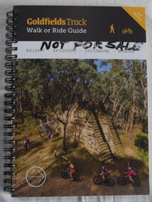
Book, Gib Wettenhall, Goldfields Track: Walk or Ride Guide. 2nd Edition, 12.2017
... The guide was written by Gib Wettenhall in collaboration with the Great Dividing Trail Association and Goldfields Tracks Inc. ...Great Dividing Trail Goldfields Cycling Walking Tracks 'Not for Sale' handwritten in Texta on the cover. ...The guide was written by Gib Wettenhall in collaboration with the Great Dividing Trail Association and Goldfields Tracks Inc. The book gives detailed information about the track including historical notes, maps and numerous photographs. Members of the Buninyong Visitor Centre and the local community actively supported the extension of the Great Dividing Trail from Ballarat through to Buninyong. Spiral bound book with photograph on cover showing mining works and tourists visiting. Title is on a black section. 'Not for Sale' handwritten in Texta on the cover.great dividing trail, goldfields, cycling, walking, tracks -
Greensborough Historical Society
Book, Melbourne Water, Plenty River Waterway Management Activity Plan 2000, 2000_
... This report covers the catchment of the Plenty River from its upper reaches in the Great Dividing Range to the confluence with the Yarra River at Viewbank. ...Greensborough Historical Society 34A Glenauburn Road Lower Plenty Lower Plenty melbourne This report covers the catchment of the Plenty River from its upper reaches in the Great Dividing Range to the confluence with the Yarra River at Viewbank. ...This report covers the catchment of the Plenty River from its upper reaches in the Great Dividing Range to the confluence with the Yarra River at Viewbank. It discusses ecological diversity and methods of improving water quality and significant areas of the catchment. Includes a brief history of settlement along the Plenty River.This is a significant plan for the improvement of the Plenty River.207 p., maps, folding maps. Printed on white paper with black spiral binding and clear plastic front cover.plenty river, melbourne water -
Eltham District Historical Society Inc
Document - Folder, Murphy, James and descendants
... Contents Note from Ray Blake, 26 April 2000: Ms Murphy said her people had traditionally owned all of inner Melbourne, north to the Great Divide, West to Werribee River, East to Mt Baw Baw, South to Mordialloc Creek....Contents Note from Ray Blake, 26 April 2000: Ms Murphy said her people had traditionally owned all of inner Melbourne, north to the Great Divide, West to Werribee River, East to Mt Baw Baw, South to Mordialloc Creek. ...James Murphy was a mining surveyor involved with the Caledonia diggings. Contents Note from Ray Blake, 26 April 2000: Ms Murphy said her people had traditionally owned all of inner Melbourne, north to the Great Divide, West to Werribee River, East to Mt Baw Baw, South to Mordialloc Creek.Newspaper clippings, A4 photocopies, etcjames murphy -
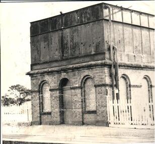 Hume City Civic Collection
Photograph, c 1974
... Steam trains needed sufficient steam power to climb the steep gradients over the Great Dividing Range and the water tower at Sunbury was used to replenish the trains' water supply for the remainder of the journey....Steam trains needed sufficient steam power to climb the steep gradients over the Great Dividing Range and the water tower at Sunbury was used to replenish the trains' water supply for the remainder of the journey. sunbury railway station water towers victorian railways bett j. george evans collection A black and white photograph of the water tower at Sunbury Railway Station. ...The mounted photograph is one of a series used for display purposes. The water tower at Sunbury Station was built in 1861 by J. Bett. it is of state significance and is an indicator of the importance of the railway to Sunbury's expansion in the Nineteenth Century. Steam trains needed sufficient steam power to climb the steep gradients over the Great Dividing Range and the water tower at Sunbury was used to replenish the trains' water supply for the remainder of the journey.A black and white photograph of the water tower at Sunbury Railway Station. The base of the tower is a brick construction with an arched doorway and two bricked in arched windows at either side of the doorway and a further two bricked in arched windows on the side. Above the base is a large square iron water storage tank with two downpipes at the side. There is a picket fence either side of the building. Mounted on board.sunbury railway station, water towers, victorian railways, bett, j., george evans collection -
![View of Sailor’s Creek Bridge / [by] Nicholas Caire, circa 1876](/media/collectors/550653872162f11fb04854aa/items/577b5b7ed0cdd10948d14ae1/item-media/577b5be9d0cdd10948d196a2/item-fit-380x285.jpg?cb=6) Kew Historical Society Inc
Kew Historical Society IncPhotograph, Anglo-Australasian Photographic Company, View of Sailor’s Creek Bridge, c.1876
... On Reverse" ‘Sailor’s Creek as situated in the Jim Crow Ranges, which Range forms a portion of the Great Dividing Range of Mountains in Victoria. These hills contain many romantic spots. ...His vision of the Australian bush and pioneer life had a counterpart in the works of Henry Lawson and other nationalist poets, authors and painters. nicholas caire (1837-1918) sailor's creek (vic) gold mining (vic) On Reverse" ‘Sailor’s Creek as situated in the Jim Crow Ranges, which Range forms a portion of the Great Dividing Range of Mountains in Victoria. These hills contain many romantic spots. ...Nicholas Caire was born on Guernsey in the Channel Islands in 1837. He arrived in Adelaide with his parents in about 1860. In 1867, following photographic journeys in Gippsland, he opened a studio in Adelaide. From 1870 to 1876 he lived and worked in Talbot in Central Victoria. In 1876 he purchased T. F. Chuck's studios in the Royal Arcade Melbourne. In 1885, following the introduction of dry plate photography, he began a series of landscape series, which were commercially successful. As a photographer, he travelled extensively through Victoria, photographing places few of his contemporaries had previously seen. He died in 1918. Reference: Jack Cato, 'Caire, Nicholas John (1837–1918)', Australian Dictionary of Biography.An original, rare photograph from the series 'Views of Victoria: General Series' by the photographer, Nicholas Caire (1837-1918). The series of 60 photographs that comprise the series was issued c. 1876 and reinforced a neo-Romantic view of the Australian landscape to which a growing nationalist movement would respond. Nicholas Caire was active as a photographer in Australia from 1858 until his death in 1918. His vision of the Australian bush and pioneer life had a counterpart in the works of Henry Lawson and other nationalist poets, authors and painters.Views of Victoria (General Series) No.31 / ‘View of Sailor’s Creek Bridge’ / Albumen silver photograph mounted on boardOn Reverse" ‘Sailor’s Creek as situated in the Jim Crow Ranges, which Range forms a portion of the Great Dividing Range of Mountains in Victoria. These hills contain many romantic spots. The one which forms the subject of the present illustration is a view of the Bridge which spans the Creek. Gold has been found throughout the course of the bed of this Creek in payable quantities. The diggers, as may be seen in the photograph, have constructed sluices in the side of the embankment for the purpose of washing the fine gold contained in the wash-dirt.’nicholas caire (1837-1918), sailor's creek (vic), gold mining (vic) -
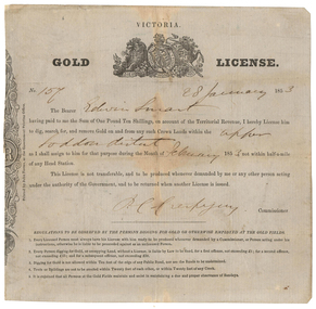 Old Colonists' Association of Ballarat Inc.
Document - Gold License, Gold License issued to Edwin Smart, 28/01/1853
... The headwaters of the Loddon River rise on the northern slopes of the Great Dividing Range east of Daylesford. The river rises below Musk near Trentham and Lyonville from where it heads northward to Glenlyon and on to Loddon Falls. ...The headwaters of the Loddon River rise on the northern slopes of the Great Dividing Range east of Daylesford. The river rises below Musk near Trentham and Lyonville from where it heads northward to Glenlyon and on to Loddon Falls. ...The Old Colonists Association Minute Book records: 'James Smart presented the Association with a Gold Diggers License dated 28th January 1853, it being resolved a vote of thanks be recorded.' The headwaters of the Loddon River rise on the northern slopes of the Great Dividing Range east of Daylesford. The river rises below Musk near Trentham and Lyonville from where it heads northward to Glenlyon and on to Loddon Falls. It then flows generally northward through Guildford and Newstead, 40 kilometres (25 mi) west of Bendigo, then towards the Murray River. The Upper Loddon Plains is within the traditional lands of the Dja Dja Wurrung people.Gold License issued to Edwin Smart on 28 January 1853 at the Upper Loddon.gold license, edwin smart, gold mining, james smart, upper loddon -
 Marysville & District Historical Society
Booklet - Paperback booklet, Ann Thomas, The Big Culvert, 1992
... ./ Some levels of elevation top the 4000 ft. mark, as it is part of the Great Dividing/Range in Victoria. I have collected just a few aspects of early times and would like/ to say thanks for the encouragement I have received, to write about one of my/ favourite subjects./ Ann Thomas..../ Some levels of elevation top the 4000 ft. mark, as it is part of the Great Dividing/Range in Victoria. I have collected just a few aspects of early times and would like/ to say thanks for the encouragement I have received, to write about one of my/ favourite subjects./ Ann Thomas Paperback. ...A history of the Big Culvert in the Cumberland Reserve and its link to the Yarra Track.Paperback. Front cover has an old photograph of the big culvert.non-fictionA history of the Big Culvert in the Cumberland Reserve and its link to the Yarra Track.big culvert, cumberland reserve, yarra track, victoria, history -
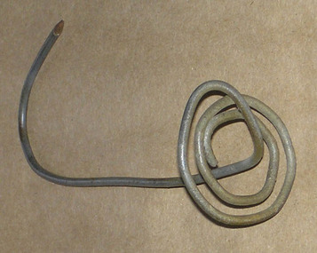 Heyfield & Districts Historical Society
Bill spike, George Edward Barraclough (1906-1981), 1940s-1950s
... George Barraclough (1907-1981), a landholder from north of Licola, in the Victorian Great Divide, made a number of these spikes, as needed. ...Heyfield & Districts Historical Society 1 Little Temple Street Heyfield gippsland George Barraclough (1907-1981), a landholder from north of Licola, in the Victorian Great Divide, made a number of these spikes, as needed. ...George Barraclough (1907-1981), a landholder from north of Licola, in the Victorian Great Divide, made a number of these spikes, as needed. As accounts were paid, receipts were pasted to the account, the account was impaled on the spike, and the spike was rehung on a nail on a wall stud. All transactions dealing with money were filed in this manner, as an orderly way of tracking items that were usually remotely ordered and delivered on the mail car. George Barraclough used No8 in a number of creative ways, and his durable and untilitarion toasting forks are still in family use today. After George died in 1981 the spikes with their accounts passed to his daughter Linda Barraclough, who archived the accounts and later made copies available for study. Those accounts form a record of the businesses of Heyfield for 1940s and 1950s.This bill hook is of historical significance as a survivor of bush ingenuity and bush filing systems. Commercially made bill spikes were in common use in offices, where they usually consisted of a heavy metal base with an upright pointed piece of wire. Number 8 fencing wire was an important and readily accessible repair commodity for rural dwellers, and achieved iconic status as the most generic method of repair for cars broken down (resort to nearest fence) and was even used to hold houses together. Referring to "No 8 fencing wire" became a type of Australian shorthand for bush ingenuity. It is no longer available, being replaced by 4mm high tensile wire. This item is important both as an example of inventive use of No8 wire, and also as an example of the bush filing methods in use in the 1940s and 1950s. No 8 fencing wire holds a similar position in New Zealand - see Wikipedia NZ at http://en.wikipedia.org/wiki/Number_8_wire A section of number 8 fencing wire twisted to form a bill spike. It has a rounded.base made from several twists of wire in a flat platform, with the remaining wire rising from the centre to form a stem that terminates in a hook with a sharpened point.wire, bush ingenuity, barraclough, licola north -
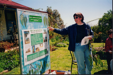 Wooragee Landcare Group
Photograph, 5 September 2004
... The Tatong Tavern is an old English style pub situated in the foothills of the Great Dividing Range the small community of Tatong 23km south-east of Benalla. ...The Tatong Tavern is an old English style pub situated in the foothills of the Great Dividing Range the small community of Tatong 23km south-east of Benalla. ...Wooragee Landcare Group took a bus trip Sunday 5th September to Samaria, Tatong area (near Benalla) to look at land use on small farms. Around this time, Wooragee Landcare were looking into how small land holders could run some enterprises. This photo was taken at Tatong Tavern where the group had lunch. The Tatong Tavern is an old English style pub situated in the foothills of the Great Dividing Range the small community of Tatong 23km south-east of Benalla. The original weatherboard hotel was originally built in the 1880s by William Worrall who was listed as Hotel Keeper from 1886 to 1910. It was destroyed by fire in 1923 and replaced by the current building, which has undergone many changes over the past 100 years. The name has also changed from the Tatong Hotel or ‘Pub’ to the current name of Tatong Tavern.Tatong is a rural village in north-east Victoria, set in undulating country that rises southwards to the Tolmie ranges. The name is thought to derive from an Aboriginal expression, possibly referring to something unseen. The Tatong pastoral run was taken up in 1847 and farm selections began in the 1870s. A school opened in 1890 (closed in 2006). Dairy herds were grazed on the Tatong flats and a cooperative creamery operated from 1892 until 1918. In 1914 a branch railway line was opened from Benalla to Tatong that carried farm produce and timber to Tatong, which had two sawmills in the 1920s. There was also a general store, a police station, and a livestock trucking yard. St Albans Church of England was built in 1921. Most of those buildings have now disappeared. The Tatong Tavern along with the Hall built in 1904 are the only remaining buildings. The Tatong Tavern is a significant tangible and visual representation of the area’s cultural and social history over the past 100 years. Coloured rectangular photograph printed on paperReverse: WAN NA E0NA2N2. NNN- 14240/ (No. 20) 373/ tatong, tatong pub, tatong tavern, tolmie ranges, tatong flats, benalla, wooragee landcare, wooragee landcare group, bus trip, samaria, land use, william worrall, 1800s, 2004, mount samaria -
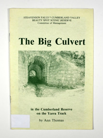 Marysville & District Historical Society
Book, Steavenson Falls-Cumberland Valley Beauty Spot Scenic Reserve Committee of Management, The Big Culvert, 1992
... ./ Some levels of elevation top the 4000 ft. mark, as it is part of the Great Dividing/Range in Victoria. I have collected just a few aspects of early times and would like/ to say thanks for the encouragement I have received, to write about one of my/ favourite subjects./ Ann Thomas With Best Wishes / Ann Thomas / 12.7.92 Stamp of Marysville & District / Historical Society Inc / P.O. ..../ Some levels of elevation top the 4000 ft. mark, as it is part of the Great Dividing/Range in Victoria. I have collected just a few aspects of early times and would like/ to say thanks for the encouragement I have received, to write about one of my/ favourite subjects./ Ann Thomas With Best Wishes / Ann Thomas / 12.7.92 Stamp of Marysville & District / Historical Society Inc / P.O. ...A history of the Big Culvert in the Cumberland Reserve and its link to the Yarra TrackPaperback. Front cover has an old photograph of the big culvert.Marysville, Vic. 3779./ January, 1992. Dear Reader,/ I hope you'll enjoy sharing with me an account of some of the excitement and/ drama of events through history on the old Yarra Track. This Reserve is, of course,/ in the heart of one of the world's great hardwood forests, where generations of my/ family have lived and worked./ Some levels of elevation top the 4000 ft. mark, as it is part of the Great Dividing/Range in Victoria. I have collected just a few aspects of early times and would like/ to say thanks for the encouragement I have received, to write about one of my/ favourite subjects./ Ann Thomas With Best Wishes / Ann Thomas / 12.7.92 Stamp of Marysville & District / Historical Society Inc / P.O. Box 22 / Marysville 3779big culvert, cumberland reserve, yarra track, victoria, history -
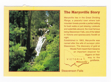 Marysville & District Historical Society
Postcard (item) - Colour postcard, Neil Cutts, The Marysville Story-Steavenson Falls, Pre 2009
... The Marysville Story/ Marysville lies in the Great Dividing/ Range, a peaceful town where lush/ mountain forests provide a perfect setting/ for bush walks or just relaxing. ...Rose Series Postcard No. 3530. marysville steavenson falls victoria postcard souvenir rose stereograph co 3530 john steavenson The Marysville Story/ Marysville lies in the Great Dividing/ Range, a peaceful town where lush/ mountain forests provide a perfect setting/ for bush walks or just relaxing. ...A postcard in a series produced by the Rose Stereograph Company in Victoria, Australia as a souvenir of Marysville.A colour photograph of Steavenson Falls in Marysville, Victoria. The Steavenson Falls is named after the Victorian Assistant Commissioner of Roads and Bridges, John Steavenson, who arrived in Victoria in the early 1860s. At 84 metres high, Steavenson Falls is Victoria's tallest cascading waterfall. The falls are split into roughly five cascades, with the last of these plunging into a small, picturesque rock pool. Rose Series Postcard No. 3530. The Marysville Story/ Marysville lies in the Great Dividing/ Range, a peaceful town where lush/ mountain forests provide a perfect setting/ for bush walks or just relaxing. Lookouts/ and waterfalls abound, the most famous/ being Steavenson Falls, one of the tallest/ in Victoria and spectacularly floodlit at/ night./ Established in 1863, Marysville was/ named after the wife of surveyor John/ Steavenson. The discovery of gold at/ Woods Point meant that it became/ an important stopover for/ diggers on their/ way to the/ goldfields. Steavenson Falls POST CARD The "Rose" Series/ De Luxe Proudly Printed in/ Australia Since 1880 AFFIX/ STAMP/HERE/ Rose Series/ Post Card No./ 3530 ADDRESS/ POSTCODE the MARYSVILLE STORY & Steavenson Falls/ MARYSVILLE, VICTORIA, AUSTRALIA/ Photo Neil Cutts Copyright Rose Stereograph Co., Glen Waverley, Victoria (03) 9560 7772marysville, steavenson falls, victoria, postcard, souvenir, rose stereograph co, 3530, john steavenson