Showing 287 items matching "greensborough - maps"
-
 Greensborough Historical Society
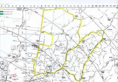
Map, Greensborough c 1980s, 1980s
... greensborough - maps...Map of Greensborough and surrounds showing bus routes servicing Eltham College....Map of Greensborough and surrounds, black print with colour markings....Greensborough c 1980s Map Map ...Map of Greensborough and surrounds showing bus routes servicing Eltham College.Map of Greensborough and surrounds, black print with colour markings."Bundoora Retirement Village" marked in red pen at E20greensborough - maps, eltham college, bus routes, public transport -
 Greensborough Historical Society
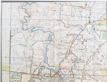
Map, John Monash, 1913 Map of Greensborough, 1913
... 1913 Map of Greensborough...Greensborough - maps...1913 Map of Greensborough, possibly by John Monash. This map shows the area to the north of the township....Greensborough - maps 1913 Colour map showing land contours and place names 1913 Map of Greensborough Map Map John Monash ...1913 Map of Greensborough, possibly by John Monash. This map shows the area to the north of the township.Colour map showing land contours and place namesgreensborough - maps, 1913 -
 Greensborough Historical Society
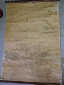
Map, Map of Greensborough - Jessop's Real Estate, 1930c
... Map of Greensborough - Jessop's Real Estate...greensborough - maps...This map of Greensborough hung in the office of Cec Jessop's Real Estate office corner Main and Grimshaw Street. ...Map of Greensborough - Jessop's Real Estate Map Map ...This map of Greensborough hung in the office of Cec Jessop's Real Estate office corner Main and Grimshaw Street. Includes a word document listing street name changes from the original map to today, according to Norm Colvin.This map was saved from the building when the business closed.Canvas roll-up map with timber rails top and bottom.greensborough - maps, cecil jessop, greensborough street names -
 Greensborough Historical Society
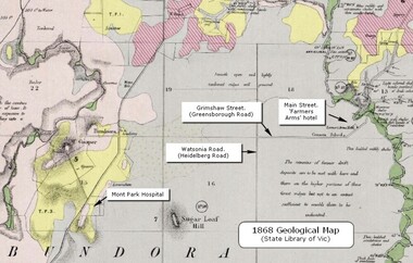
Map - Geological Map, 1868 Geological map of Greensborough (annotated), 1868_
... 1868 Geological map of Greensborough (annotated)...Greensborough - maps...Digital copy of colour map. 1868 Geological map of Greensborough (annotated) Map Geological Map Ian Bryant ...This geological map from the State Library of Victoria collection has been annotated by GHS member Ian Bryant to show some local landmarksDigital copy of colour map.Annotations on map show locations.greensborough - maps, 1860s melbourne, suburbs, geography, roads -
 Greensborough Historical Society
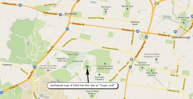
Map, Overlay/comparison Map for 1868 Greensborough-Bundoora Geological Map area, 1868_
... Overlay/comparison Map for 1868 Greensborough-Bundoora Geological Map area.......greensborough - maps...Overlay/comparison Map for 1868 Greensborough-Bundoora Geological Map area. ...This map is a comparison to the map at Item 2518, questioning the location of "Sugar Loaf". Annotation by GHS member Ian Bryant.Map copied from Google maps.Annotation on map.sugarloaf hill, bundoora, greensborough - maps -
 Greensborough Historical Society
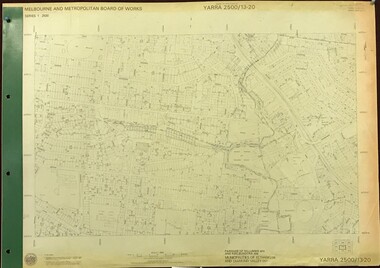
Map, Melbourne and Metropolitan Board of Works. Survey Division, MMBW, Yarra 2500 / 13.20. Greensborough, Montmorency and Watsonia, 1979_03
... ...greensborough - maps...Yarra 2500 [base map] 13-20. Greensborough, Montmorency and Watsonia. ...Greensborough, Montmorency and Watsonia. Map Map Melbourne and Metropolitan Board of Works. ...Melbourne and Metropolitan Board of Works. Yarra 2500 [base map] 13-20. Greensborough, Montmorency and Watsonia. Parishes of Nillumbik 3310 and Keelbundora 2856. Municipalities of Eltham 238 and Diamond Valley 257. Prominent streets include: Nell Street, Nepean Street and Alexandra Street. Includes Montmorency High School.MMBW Map in 1:2500 [scale] series. Cream parchment with green tape reinforcing on edges and punched holes on left edge.mmbw, melbourne and metropolitan board of works, shire of diamond valley, greensborough - maps, montmorency - maps, watsonia - maps -
 Greensborough Historical Society
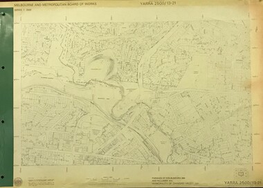
Map, Melbourne and Metropolitan Board of Works. Survey Division, MMBW, Yarra 2500 / 13.21. Central Greensborough, 1979_05
... ...greensborough - maps...map]. 13-21, Parishes of Keelbundora 2856 and Nillumbik 3310, Municipality of Diamond Valley 257. Shows street names, easement sizes, lot numbers, lodged plan numbers, names of prominent features, contour values, creek or river names. Central Greensborough...MMBW, Yarra 2500 / 13.21. Central Greensborough. Map Map Melbourne and Metropolitan Board of Works. ...Melbourne and Metropolitan Board of Works. Yarra 2500 [base map]. 13-21, Parishes of Keelbundora 2856 and Nillumbik 3310, Municipality of Diamond Valley 257. Shows street names, easement sizes, lot numbers, lodged plan numbers, names of prominent features, contour values, creek or river names. Central Greensborough. Prominent streets: Main Street, Para Road, St Helena Road and Diamond Creek Road.MMBW Map in 1:2500 [scale] series. Cream parchment with green tape reinforcing on edges and punched holes on left edge.mmbw, melbourne and metropolitan board of works, shire of diamond valley, greensborough - maps -
 Greensborough Historical Society
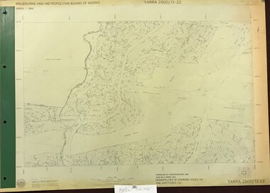
Map, Melbourne and Metropolitan Board of Works. Survey Division, MMBW, Yarra 2500 / 13.22. Greensborough, Apollo Parkways, 1979_06
... ...greensborough - maps...Yarra 2500 [base map] 13-22. Greensborough, Apollo Parkways. Parishes of Nillumbik 3310 and Keelbundora 2856. ...MMBW, Yarra 2500 / 13.22. Greensborough, Apollo Parkways Map Map Melbourne and Metropolitan Board of Works. ...Melbourne and Metropolitan Board of Works. Yarra 2500 [base map] 13-22. Greensborough, Apollo Parkways. Parishes of Nillumbik 3310 and Keelbundora 2856. Municipalities of Diamond Valley 257 and Whittlesea 239. Prominent streets include: Plenty River Drive, Diamond Creek Road and Civic Drive. Includes Diamond Valley Civi Centre, Churinga, Janefield Colony Reserve and "proposed freeway" now Greensborough Highway (Bypass)MMBW Map in 1:2500 [scale] series. Cream parchment with green tape reinforcing on edges and punched holes on left edge.mmbw, melbourne and metropolitan board of works, shire of diamond valley, greensborough - maps, apollo parkways - maps -
 Greensborough Historical Society
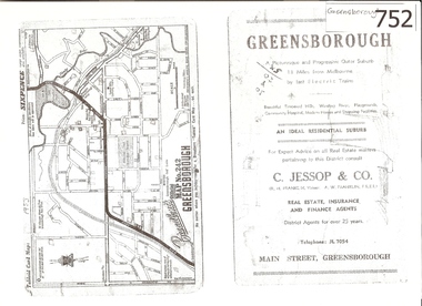
Map, Broadbent's, Greensborough, 1953_
... greensborough...c jessop...broadbents...map...A 1 page photocopy of a road map of Greensborough from 1953....Greensborough Map Broadbent's ...This road map was a part of a Broadbent's Melbourne suburban directory from 1953.It shows the lay out of Greensborough's streets in 1953.It also shows some different street names to those used today. It also features a C Jessop & Co. Real estate advertisementA 1 page photocopy of a road map of Greensborough from 1953.Nilgreensborough, c jessop, broadbents, map no 242, road maps, 1953 -
 Greensborough Historical Society
Article and Photograph, Henry Street Greensborough, 2017_
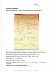
... Map and information about Henry Street Greensborough, map drawn in 1999 by Valma Simpkins (nee Poulter) of residents and businesses in Henry Street near Grimshaw Street in the 1930s. ...Greensborough Historical Society 34A Glenauburn Road Lower Plenty Lower Plenty melbourne Map and information about Henry Street Greensborough, map drawn in 1999 by Valma Simpkins (nee Poulter) of residents and businesses in Henry Street near Grimshaw Street in the 1930s. ...Map and information about Henry Street Greensborough, map drawn in 1999 by Valma Simpkins (nee Poulter) of residents and businesses in Henry Street near Grimshaw Street in the 1930s. Further discussion about Poulter and Clayton family connectionsThis photograph and text was copied from a Facebook site. Members are people who lived in the Greensborough area and share their reminiscences of the area with others. The site is administered by a GHS member but is not officially affiliated with the Society. Any information is the opinion of the contributor. Article and photograph sourced from social media.henry street greensborough, valma poulter, valma simpkins, clayton family -
 Greensborough Historical Society
CD-ROM, Neil McPherson, Scout Pathfinder Badge 1951, 1951_
... Detailed description and maps of Greensborough area, including roads and streets and natural features in 1951. ...Greensborough Historical Society 34A Glenauburn Road Lower Plenty Lower Plenty melbourne Detailed description and maps of Greensborough area, including roads and streets and natural features in 1951. ...Detailed description and maps of Greensborough area, including roads and streets and natural features in 1951. Report made to satisfy requirements for award of a Scout Pathfinder badge.Very detailed description of the Greensborough area in 1951, by Neil McPherson, Troop Leader, 6th PrestonCD-ROM, containing 30 files Adobe 12.5 x 14.2 cm Photoshop 7greensborough, scouts, pathfinder badge -
 Eltham District Historical Society Inc
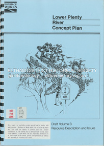
Book, Brett Cheatley et al, Lower Plenty River Concept Plan; Maroondah Pipetrack - Greensborough to Yarra/Plenty Confluence; Draft Volume B, Resource Description and Issues, February 1991
... Eltham District Historical Society Inc 728 Main Rd Eltham melbourne Concept Plan Melbourne Metropolitan Board of Works Plenty River Report Spiral bound A4, 33 pages inculding foldoiut A3 tables and maps (some coloured) 4 copies Lower Plenty River Concept Plan; Maroondah Pipetrack - Greensborough to Yarra/Plenty Confluence; Draft Volume B, Resource Description and Issues Book Book Brett Cheatley Ian Womersley Mal Warren Melbourne and Metropolitan Board of Works (Vic.). ...concept plan, melbourne metropolitan board of works, plenty river, report -
 Greensborough Historical Society
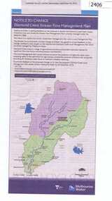
Newspaper Clipping, Diamond Creek stream flow management plan, 30/09/2015
... Greensborough Historical Society 34A Glenauburn Road Lower Plenty Lower Plenty melbourne In this Public Notice, Melbourne Water seeks feedback on the Diamond Creek Stream Flow Management Plan. diamond creek stream flow management plan melbourne water. News clipping, black text, colour map ...In this Public Notice, Melbourne Water seeks feedback on the Diamond Creek Stream Flow Management Plan.News clipping, black text, colour map.diamond creek stream flow management plan, melbourne water. -
 Greensborough Historical Society
Book, Angus & Robertson Ltd, The Australian Encyclopaedia, 1958_
... Greensborough Historical Society 34A Glenauburn Road Lower Plenty Lower Plenty melbourne Standard history of Australia to 1958 australian encyclopaedia 10 vols. illus. maps with index vol. 10 The Australian Encyclopaedia Book Angus & Robertson Ltd ...Standard history of Australia to 195810 vols. illus. maps with index vol. 10australian encyclopaedia -
 Greensborough Historical Society
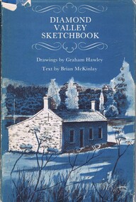
Book, Diamond Valley Sketchbook, 1973_
... Shows landmarks around the Diamond Valley. diamond valley eltham greensborough "Happy birthday Kathryn May 1976" 63p., illus., map as endpapers, dustcover. ...Contains drawings by Graham Hawley and text by Brian McKinley. Shows landmarks around the Diamond Valley.63p., illus., map as endpapers, dustcover."Happy birthday Kathryn May 1976"diamond valley, eltham, greensborough -
 Greensborough Historical Society
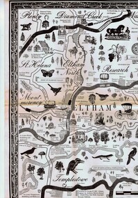
Map, George W. Bell, Eltham Warrandyte and environs: a visitor's guide map: centenary souvenir. 2nd ed, 1994c
... Greensborough Historical Society 34A Glenauburn Road Lower Plenty Lower Plenty melbourne Tourist guide to historic and other features in the Eltham Warrandyte area and environs, warrandyte eltham st helena montmorency A2, black & white, folded 3 times to A5, printed on one side Eltham Warrandyte and environs: a visitor's guide map: centenary souvenir. 2nd ed. ...Tourist guide to historic and other features in the Eltham Warrandyte area and environs, A2, black & white, folded 3 times to A5, printed on one sidewarrandyte, eltham, st helena, montmorency -
 Greensborough Historical Society
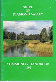
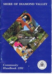
Book, Shire of Diamond Valley, Shire of Diamond Valley Community Handbook 1992, 1992_
... maps. Cover illustration of Kalparrin Gardens Greensborough...Greensborough Historical Society 34A Glenauburn Road Lower Plenty Lower Plenty melbourne Guide to services provided by Shire of Diamond Valley. The Shire of Diamond Valley was a Local Government Area located about 20 kilometres northeast of Melbourne. The shire covered an area of 74.38 square kilometres and existed from 1964 until 1994. Annual guide to services in Shire of Diamond Valley shire of diamond valley 52 pages, col illus., maps ...Guide to services provided by Shire of Diamond Valley. The Shire of Diamond Valley was a Local Government Area located about 20 kilometres northeast of Melbourne. The shire covered an area of 74.38 square kilometres and existed from 1964 until 1994.Annual guide to services in Shire of Diamond Valley52 pages, col illus., maps. Cover illustration of Kalparrin Gardens Greensboroughshire of diamond valley -
 Greensborough Historical Society
Book, Shire of Diamond Valley, Shire of Diamond Valley Community Handbook 1991, 1991_
... Greensborough Historical Society 34A Glenauburn Road Lower Plenty Lower Plenty melbourne Guide to services provided by Shire of Diamond Valley. The Shire of Diamond Valley was a Local Government Area located about 20 kilometres northeast of Melbourne. The shire covered an area of 74.38 square kilometres and existed from 1964 until 1994. Annual guide to services in Shire of Diamond Valley shire of diamond valley 36 pages, col. illus., maps ...Guide to services provided by Shire of Diamond Valley. The Shire of Diamond Valley was a Local Government Area located about 20 kilometres northeast of Melbourne. The shire covered an area of 74.38 square kilometres and existed from 1964 until 1994.Annual guide to services in Shire of Diamond Valley36 pages, col. illus., maps. Front cover is a collage of scenes from Diamond Valley, back cover illustration of a copy of "Summer Panorama, Tabletop, NSW" by Max Dimmack, from the Shire of Diamond Valley Art Collection.shire of diamond valley -
 Greensborough Historical Society
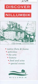
Leaflet, Nillumbik Shire Council, Discover Nillumbik, 2000c
... Greensborough Historical Society 34A Glenauburn Road Lower Plenty Lower Plenty melbourne Map and lists of attractions within the Shire of Nillumbik nillumbik Double sided, folded seven times printed in red and green Discover Nillumbik Leaflet Nillumbik Shire Council ...Map and lists of attractions within the Shire of NillumbikDouble sided, folded seven times printed in red and greennillumbik -
 Greensborough Historical Society
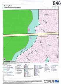
Map, Plenty River Children's Cemetery - location map, 1848-1860
... Greensborough district. Descendants of both families still live in the area. One page map accompanies article item #804 Plenty River Children's Cemetery - location map Map Map Greensborough Historical Society ...The unmarked graves of the children of two Greensborough pioneer families lie in a private cemetery on the Plenty River. Burials occurred between 1848 and 1860.The significance lies in the association with two of the pioneer families of the Greensborough district. Descendants of both families still live in the area.One page map accompanies article item #804 -
 Greensborough Historical Society
Map, Scotprint, A Guide to World War II 'Invasion or Liberation': Western Europe Sept 1939 to March 1945, 1999_
... Greensborough Historical Society 34A Glenauburn Road Lower Plenty Lower Plenty melbourne Notes of battles, military leaders, cemeteries and other features of World War 11 Western Europe. world war ii Double sided col. maps, with notes of battles, military leaders, cemeteries and other features of World War 11 Western Europe. ...Notes of battles, military leaders, cemeteries and other features of World War 11 Western Europe.Double sided col. maps, with notes of battles, military leaders, cemeteries and other features of World War 11 Western Europe.world war ii -
 Greensborough Historical Society
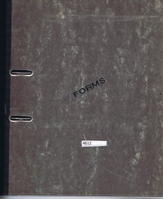
Folder, Shire of Diamond Valley, Shire of Diamond Valley forms, 1980-1994
... Greensborough Historical Society 34A Glenauburn Road Lower Plenty Lower Plenty melbourne Forms, staff telephone lists, organisation charts, maps, administrative memos, directives and bulletins used by the Shire of Diamond Valley 1980s -1994. shire of diamond valley Arch file containing forms etc. used by the Shire of Diamond Valley Shire of Diamond Valley forms Folder Shire of Diamond Valley ...Forms, staff telephone lists, organisation charts, maps, administrative memos, directives and bulletins used by the Shire of Diamond Valley 1980s -1994.Arch file containing forms etc. used by the Shire of Diamond Valleyshire of diamond valley -
![Planning Document, Plan of proposed subdivision of land in Greensborough [Map shows Scotland house], 01/04/1971](/media/collectors/4f729f5697f83e03086015b8/items/5982a68921ea6b1420e4e560/item-media/59916fb521ea681094908d7a/item-fit-380x285.jpg?cb=6) Greensborough Historical Society
Greensborough Historical SocietyPlanning Document, Plan of proposed subdivision of land in Greensborough [Map shows Scotland house], 01/04/1971
... Plan of proposed subdivision of land in Greensborough [Map shows Scotland house]...Plan of proposed subdivision of land in Greensborough [Map shows Scotland house] Planning Document ...This subdivision of Greensborough shows the home of John Scotland (died 1888) and surrounding area bounded by Hailes, William, Lorimer, and Jessop Streets.Photocopy of plan, 2 pages.Part of plan (68G) of proposed subdivision of Greensborough, part of Crown Portion 18, Parish pf Keelbundora. Scale: 132 ft. to an inchjohn scotland, hailes street greensborough, william street greensborough, lorimer street greensborough, jessop street greensborough -
 Greensborough Historical Society
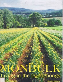
Book, Dorothy Williams, Monbulk: living in the Dandenongs, a social history, by Dorothy Williams, 1998_
... Greensborough Historical Society 34A Glenauburn Road Lower Plenty Lower Plenty melbourne History of Monbulk from early settlement in 1837 to 1997. monbulk mount dandenong Paperback, 325 p., black and white photographs, maps. ...History of Monbulk from early settlement in 1837 to 1997.Paperback, 325 p., black and white photographs, maps.monbulk, mount dandenong -
 Greensborough Historical Society
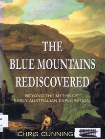
Book, Chris Cunningham, The Blue Mountains rediscovered: beyond the myths of early Australian exploration, by Chris Cunningham, 1996_
... Greensborough Historical Society 34A Glenauburn Road Lower Plenty Lower Plenty melbourne Written from both an historical and geographical view, this book tells the story of early inland exploration across the Blue Mountains. blue mountains nsw Paperback, 192 p., col. photographs, black and white maps. ...Written from both an historical and geographical view, this book tells the story of early inland exploration across the Blue Mountains.Paperback, 192 p., col. photographs, black and white maps.blue mountains nsw -
 Greensborough Historical Society
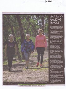
Newspaper Clipping, Diamond Valley Leader, Map risky walking tracks, 29/03/2017
... Greensborough Historical Society 34A Glenauburn Road Lower Plenty Lower Plenty melbourne Walkers are being urged to dob in dubious walking tracks in a bid to attract funding for improvements. walking tracks walkspot project womens walking wanderers News article 1 page, black text, colour image. Map ...Walkers are being urged to dob in dubious walking tracks in a bid to attract funding for improvements.News article 1 page, black text, colour image.walking tracks, walkspot project, womens walking wanderers -
 Greensborough Historical Society
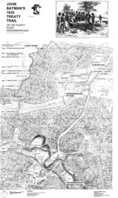
Map, Dennis Ward, John Batman's 1835 Treaty Trail on the Plenty River, 2010_
... Map of the Plenty River through Greensborough and surrounding areas, annotated with historic places. ...Greensborough Historical Society 34A Glenauburn Road Lower Plenty Lower Plenty melbourne Map of the Plenty River through Greensborough and surrounding areas, annotated with historic places. ...Map of the Plenty River through Greensborough and surrounding areas, annotated with historic places. Prepared by Dennis Ward, this map shows places of interest with historic markers for a proposed Heritage Trail along the Plenty. This was a joint project of Dennis Ward, Rotary Greensborough and Nillumbik Historical Society.This map shows many places of interest along the Plenty River. Large laminated map, including land subdivisions and street names.plenty river heritage trail -
 Greensborough Historical Society
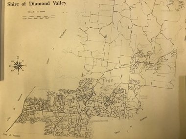
Map, Shire of Diamond Valley, 1964-1994
... Map of the former Shire of Diamond Valley, 1964-1994, showing the local government area from Greensborough to Hurstbridge....Greensborough Historical Society 34A Glenauburn Road Lower Plenty Lower Plenty melbourne Map of the former Shire of Diamond Valley, 1964-1994, showing the local government area from Greensborough to Hurstbridge. shire of diamond valley greensborough hurstbridge Map on yellowed paper. ...Map of the former Shire of Diamond Valley, 1964-1994, showing the local government area from Greensborough to Hurstbridge.Map on yellowed paper.shire of diamond valley, greensborough, hurstbridge -
 Greensborough Historical Society
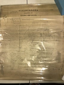
Map, Victoria. Department of Crown Lands and Survey, Keelbundoora; Counties of Bourke and Evelyn, 1950c
... Greensborough Historical Society 34A Glenauburn Road Lower Plenty Lower Plenty melbourne Map of the Victorian counties of Bourke and Evelyn showing parish boundaries and land ownership. ...Map of the Victorian counties of Bourke and Evelyn showing parish boundaries and land ownership.Show the original landholders for this area.Map on light brown parchment, covered in plastic."L.5305" and "3462" -
 Greensborough Historical Society
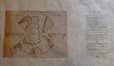
Map, Mapping Authority of NSW, Terra Australis: Quinta Pars Orbis, 1676_
... Greensborough Historical Society 34A Glenauburn Road Lower Plenty Lower Plenty melbourne The original of this map was drawn by an Italian priest Father Victorio Riccio in 1676 from knowledge brought to Manila on Dutch ships. ...The original of this map was drawn by an Italian priest Father Victorio Riccio in 1676 from knowledge brought to Manila on Dutch ships. Father Riccio was suggesting a Catholic mission to Terra Australia.Reproduction of an early map of Australia, pre-dating the voyages of Captain Cook.Facsimile map in cardboard protective tubeterra australis