Showing 44 items matching "grotto"
-
 Bass Coast Shire Council - Art Collection
Unknown - Toffey, Pauline Grotto
... Pauline Grotto...Bass Coast Shire Council - Art Collection 76 McBride Ave Wonthaggi Australia Wood Pauline Grotto Unknown Toffey ...AustraliaWood -
Bass Coast Shire Council - Art Collection
Artwork, other - Bright Outlook, Pauline Grotto
... Pauline Grotto...Bass Coast Shire Council - Art Collection 76 McBride Ave Wonthaggi Australia Signed Acrylic and oil Pauline Grotto Artwork, other Bright Outlook ...AustraliaAcrylic and oilSigned -
 Kew Historical Society Inc
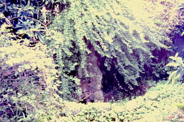
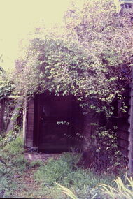
Slide - Grotto of 'Reno', St John 's Parade, 1977
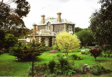
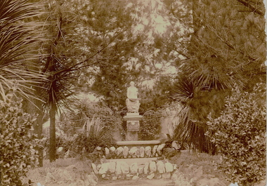
... The MMBW Detail Plan No.1576 (1904) shows the remaining portion of the original land holding, including a semi-circular pathway at the front, and garden features such as an aviary, a fountain and grotto, and a fernery. The garden including rare plants supplied by Baron Von Mueller, surrounds the cottage in a tangled frenzy. ...Colour positive transparency (slide) of the grotto in the garden of 'Reno' in St John's Parade, Kew (demolished 1977). ...Slide Grotto of 'Reno', St John 's Parade ...‘Reno’, stood on the east side of St John’s Parade. Its earliest recorded owner was the architect Samuel Cocking who lived there from c.1865 until his death in 1888. The original landholding was bordered by Cotham Road, Glenferrie Road, Wellington Street, and Charles Street. The southern portion of this land included a fine orchard, with many imported trees. The old summer house, at first in the orchard, was later removed to the house garden. The MMBW Detail Plan No.1576 (1904) shows the remaining portion of the original land holding, including a semi-circular pathway at the front, and garden features such as an aviary, a fountain and grotto, and a fernery. The garden including rare plants supplied by Baron Von Mueller, surrounds the cottage in a tangled frenzy. Despite a ‘local significance’ classification by the National Trust, the house was demolished in 1977.Rare photograph of an historically important weatherboard cottage in St John's Parade.Colour positive transparency (slide) of the grotto in the garden of 'Reno' in St John's Parade, Kew (demolished 1977). historic houses -- kew (vic.), reno -- st john's parade -- kew (vic.) -
 Bendigo Historical Society Inc.
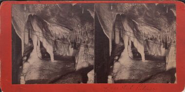
Photograph - HARRIS COLLECTION: STEREOSCOPIC VIEWS, Early 20 th Century
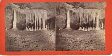
... Gem of the West. 5. Millys Grotto. 6. Lucinda...Hand written Coral Grotto 2. Crystal Palace. 3. Crystal City. 4. ...Stereoscopic Views. J Rowe Jenolan Caves. 1. Hand written Coral Grotto 2. Crystal Palace. 3. Crystal City. 4. Gem of the West. 5. Millys Grotto. 6. LucindaJ Rowe, Jenolan Caves & Blue Mountainsphotography, viewers -
 Lakes Entrance Historical Society
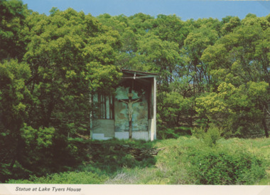
Photograph - Lake Tyers House, NU Color Vve, c1970
... Colour postcard of crucifix statue in grotto surrounded by scrub and timber, Lake Tyers House, Lake Tyers Victoria...Lakes Entrance Historical Society 4 Marine Parade Lakes Entrance gippsland Postcard was Produced for sale by Lake Tyers Scenic Boat Trips Jetties Waterways Statue at Lake Tyers House Colour postcard of crucifix statue in grotto surrounded by scrub and timber, Lake Tyers House, Lake Tyers Victoria Photograph Lake Tyers House NU Color Vve ...Postcard was Produced for sale by Lake Tyers Scenic Boat TripsColour postcard of crucifix statue in grotto surrounded by scrub and timber, Lake Tyers House, Lake Tyers VictoriaStatue at Lake Tyers Housejetties, waterways -
 University of Melbourne, Burnley Campus Archives
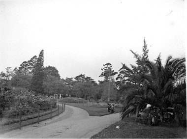
Photograph - Black and white photographs, Ballarat Botanic Gardens, Early 1900s
... Flower beds and lawns with people seated on benches. 2. A Grotto surrounded by flowering plants....Flower beds and lawns with people seated on benches. 2. A Grotto surrounded by flowering plants. Ballarat Botanic Gardens Photograph Black and white photographs ...ballarat botanic gardens, excursion, garden design -
 Bendigo Historical Society Inc.
Photograph - BLACK AND WHITE PHOTO: JENOLAN CAVES AND BLUE MOUNTAINS
... black and white photo x 2 'Picturesque Stereoscopic views of Jenolan caves and blue mountains /photographed and published by J Rowe , Jenolan Caves / heavy cardboard / Nellys Grotto...History House 11 Mackenzie Street Bendigo goldfields PHOTOGRAPH Landscape Jenolan caves and blue mountains / photographed and published by J Rowe J Rowe black and white photo x 2 'Picturesque Stereoscopic views of Jenolan caves and blue mountains /photographed and published by J Rowe , Jenolan Caves / heavy cardboard / Nellys Grotto Photograph BLACK AND WHITE PHOTO: JENOLAN CAVES AND BLUE MOUNTAINS ...black and white photo x 2 'Picturesque Stereoscopic views of Jenolan caves and blue mountains /photographed and published by J Rowe , Jenolan Caves / heavy cardboard / Nellys GrottoJ Rowephotograph, landscape, jenolan caves and blue mountains / photographed and published by j rowe -
 Bendigo Historical Society Inc.
Slide - BENDIGO VIEWS, Feb 1961
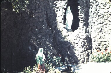
... Statue of a lady wearing white and light robes standing in a grotto. Kneeling to her right, on the ground is another lady wearing a green veil and a brown dress. ...Statue of a lady wearing white and light robes standing in a grotto. Kneeling to her right, on the ground is another lady wearing a green veil and a brown dress. ...Slide. Bendigo Views. Statue of a lady wearing white and light robes standing in a grotto. Kneeling to her right, on the ground is another lady wearing a green veil and a brown dress. She is kneeling in amongst some plants.slide, bendigo, bendigo views, bendigo views -
 Bendigo Historical Society Inc.
Slide - BENDIGO VIEWS, Jun 1970
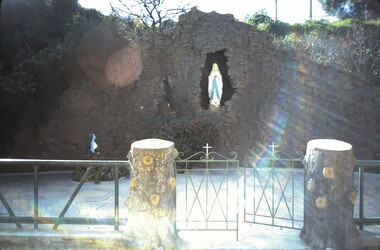
... Statue of a Lady standing in a rock grotto. Another statue of a lady wearing a blue veil and a brown dress kneeling to the left (possibly in grounds of St Killians Church) . ...Statue of a Lady standing in a rock grotto. Another statue of a lady wearing a blue veil and a brown dress kneeling to the left (possibly in grounds of St Killians Church) . ...Slide. Bendigo views. Statue of a Lady standing in a rock grotto. Another statue of a lady wearing a blue veil and a brown dress kneeling to the left (possibly in grounds of St Killians Church) . A green fence and two small green gates with white crosses on the tops are in front of the statues. There is a tree stump on each side of the gates.slide, bendigo, bendigo views, bendigo views -
 Eltham District Historical Society Inc
Photograph - Digital Photograph, Alan King, Stonygrad, 34 Hamilton Road, North Warrandyte, 30 January 2008
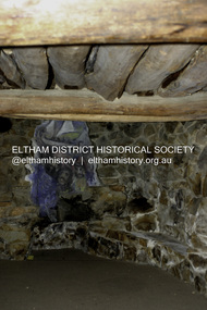
... Stonygrad is reminiscent of a grotto and in parts, of a sculpture. Covered under Heritage Overlay, Nillumbik Planning Scheme. ...Stonygrad is reminiscent of a grotto and in parts, of a sculpture. Covered under Heritage Overlay, Nillumbik Planning Scheme. ...Vassilieff dynamited rock from his own property to build his house. Stonygrad is reminiscent of a grotto and in parts, of a sculpture. Covered under Heritage Overlay, Nillumbik Planning Scheme. Published: Nillumbik Now and Then / Marguerite Marshall 2008; photographs Alan King with Marguerite Marshall.; p135This collection of almost 130 photos about places and people within the Shire of Nillumbik, an urban and rural municipality in Melbourne's north, contributes to an understanding of the history of the Shire. Published in 2008 immediately prior to the Black Saturday bushfires of February 7, 2009, it documents sites that were impacted, and in some cases destroyed by the fires. It includes photographs taken especially for the publication, creating a unique time capsule representing the Shire in the early 21st century. It remains the most recent comprehenesive publication devoted to the Shire's history connecting local residents to the past. nillumbik now and then (marshall-king) collection, danila vassilieff, hamilton road, north warrandyte, stonygrad -
 Sunbury Family History and Heritage Society Inc.
Photograph
... The building of Rupertswood mansion, along with the Lodge, the lake, gardens, grotto, stables and outbuildings, were completed in August 1874, seven months after William John Turner Clarke died at Essendon on 13th January 1874 so he never lived to see his grand mansion completed....The building of Rupertswood mansion, along with the Lodge, the lake, gardens, grotto, stables and outbuildings, were completed in August 1874, seven months after William John Turner Clarke died at Essendon on 13th January 1874 so he never lived to see his grand mansion completed. ...The house in the photograph is the Gatehouse for Rupertswood Mansion. The building of Rupertswood mansion, along with the Lodge, the lake, gardens, grotto, stables and outbuildings, were completed in August 1874, seven months after William John Turner Clarke died at Essendon on 13th January 1874 so he never lived to see his grand mansion completed.Rupertswood Mansion is one of a number of grand homes that wealthy European settlers built in various places in Australia in the nineteenth century.A non-digital coloured photograph of a bluestone two storey cottage with a hipped roof, set in an attractive garden comprising shrubs, trees and flower beds.gatehouses, rupertswood mansion, william j.t. clarke, sunbury -
 Bendigo Historical Society Inc.
Photograph - ROSALIND PARK - GROTTO AND FOUNTAIN, 1890 ?
... Top basin, Camp Hill Cascades' On back, ' grotto and fountain, Rosalind Park on Camp Hill above the sound shell, between 1881 - 1890, W.C. ...Photograph ROSALIND PARK - GROTTO AND FOUNTAIN ...sepia photo: garden with statue of female holding large shell. On pedestal, basin with rock surrounds, trees, shrubs, cacti, wire netting fence across. James Lerk 18.2.2000 ' Psychi' by E. Sempler, for W.C. Vahland. Top basin, Camp Hill Cascades' On back, ' grotto and fountain, Rosalind Park on Camp Hill above the sound shell, between 1881 - 1890, W.C. Harry ? RHSV stamp on back with '1959'/48.place, public gardens, rosalind park -
 Ringwood and District Historical Society
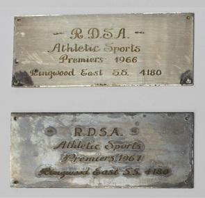
Award, RDSA / Ringwood East State School Premiers engraved award base plates - 1966 & 1967, 1966
... The members of the team are: Elizabeth Campbell (capt.), Rhonda Dick (vice-capt.), Lynda Williams, Janine Stubbs, Kaye Hinds, Pauline Grotto and Jenny Cleary, and the reserves, Margaret Taylor and Rhonda Clarke. ...The members of the team are: Elizabeth Campbell (capt.), Rhonda Dick (vice-capt.), Lynda Williams, Janine Stubbs, Kaye Hinds, Pauline Grotto and Jenny Cleary, and the reserves, Margaret Taylor and Rhonda Clarke. ...Two engraved metal plates (unmounted) - Ringwood East State School Athletic Sports Premierships in 1966 and 1967, and Ringwood Mail newspaper clipping dated 25 August, 1966, regarding basketball premiership records achieved by the school.RDSA /Athletic sports/Premiers 1966/ Ringwood East State School 4180 RDSA /Athletic sports/Premiers 1967/ Ringwood East State School 4180 Newspaper article includes: ... At the metropolitan semi-finals on August 17, East defeated Pascoe Vale 23-17, and in the final, East, in a close-fought match, defeated Campmeadows 33-31. The members of the team are: Elizabeth Campbell (capt.), Rhonda Dick (vice-capt.), Lynda Williams, Janine Stubbs, Kaye Hinds, Pauline Grotto and Jenny Cleary, and the reserves, Margaret Taylor and Rhonda Clarke. The girls are coached by Mr. John Deany. -
 Bendigo Historical Society Inc.
Newspaper - JENNY FOLEY COLLECTION: DRESSED TO KILL
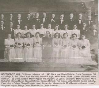
... Back row: Kevin Walshe, Frank Dorrington, Bill O'Donoghue, Jim Grotto, Alan Banfield, Bernie Keogh, Kevin Ryan, Noel Looney, Unknown, Tony Norman, Ted Crisp. ...Back row: Kevin Walshe, Frank Dorrington, Bill O'Donoghue, Jim Grotto, Alan Banfield, Bernie Keogh, Kevin Ryan, Noel Looney, Unknown, Tony Norman, Ted Crisp. ...BHS CollectionBendigo Advertiser ''The way we were'' from 2003. Dressed to kill: St Killian's debutant ball, 1943. Back row: Kevin Walshe, Frank Dorrington, Bill O'Donoghue, Jim Grotto, Alan Banfield, Bernie Keogh, Kevin Ryan, Noel Looney, Unknown, Tony Norman, Ted Crisp. Middle: Marty Hogan, Pat Murphy, Lil Jarvis, Unknown, Marie Stanley, Myra Mulvahill, Monica Burke, Gwen Hoffman, Doreen Doherty, Pat Green, John Gaskill, Bernie Doherty. Front: Joyce Cullen, Elaine Chapple, Joan Kenworthy, Marge Jarvis, Mrs Owens (matron of honour), Margaret Hogan, Marge Dean, Marie Booth, Joan Sheehan. The clip is in a folder.newspaper, bendigo advertiser, the way we were -
 Kew Historical Society Inc
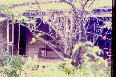
Slide - 'Reno', St John 's Parade, 1977
... The MMBW Detail Plan No.1576 (1904) shows the remaining portion of the original land holding, including a semi-circular pathway at the front, and garden features such as an aviary, a fountain and grotto, and a fernery. The garden including rare plants supplied by Baron Von Mueller, surrounds the cottage in a tangled frenzy. ...The MMBW Detail Plan No.1576 (1904) shows the remaining portion of the original land holding, including a semi-circular pathway at the front, and garden features such as an aviary, a fountain and grotto, and a fernery. The garden including rare plants supplied by Baron Von Mueller, surrounds the cottage in a tangled frenzy. ...‘Reno’, stood on the east side of St John’s Parade. Its earliest recorded owner was the architect Samuel Cocking who lived there from c.1865 until his death in 1888. The original landholding was bordered by Cotham Road, Glenferrie Road, Wellington Street, and Charles Street. The southern portion of this land included a fine orchard, with many imported trees. The old summer house, at first in the orchard, was later removed to the house garden. The MMBW Detail Plan No.1576 (1904) shows the remaining portion of the original land holding, including a semi-circular pathway at the front, and garden features such as an aviary, a fountain and grotto, and a fernery. The garden including rare plants supplied by Baron Von Mueller, surrounds the cottage in a tangled frenzy. Despite a ‘local significance’ classification by the National Trust, the house was demolished in 1977.Rare photograph of an historically important weatherboard cottage in St John's Parade.Colour positive transparency (slide) of the verandah of 'Reno' in St John's Parade, Kew (demolished 1977). historic houses -- kew (vic.), reno -- st john's parade -- kew (vic.) -
 Kew Historical Society Inc
Slide - 'Reno', St John 's Parade, 1977
... The MMBW Detail Plan No.1576 (1904) shows the remaining portion of the original land holding, including a semi-circular pathway at the front, and garden features such as an aviary, a fountain and grotto, and a fernery. The garden including rare plants supplied by Baron Von Mueller, surrounds the cottage in a tangled frenzy. ...The MMBW Detail Plan No.1576 (1904) shows the remaining portion of the original land holding, including a semi-circular pathway at the front, and garden features such as an aviary, a fountain and grotto, and a fernery. The garden including rare plants supplied by Baron Von Mueller, surrounds the cottage in a tangled frenzy. ...‘Reno’, stood on the east side of St John’s Parade. Its earliest recorded owner was the architect Samuel Cocking who lived there from c.1865 until his death in 1888. The original landholding was bordered by Cotham Road, Glenferrie Road, Wellington Street, and Charles Street. The southern portion of this land included a fine orchard, with many imported trees. The old summer house, at first in the orchard, was later removed to the house garden. The MMBW Detail Plan No.1576 (1904) shows the remaining portion of the original land holding, including a semi-circular pathway at the front, and garden features such as an aviary, a fountain and grotto, and a fernery. The garden including rare plants supplied by Baron Von Mueller, surrounds the cottage in a tangled frenzy. Despite a ‘local significance’ classification by the National Trust, the house was demolished in 1977.Rare photograph of an historically important weatherboard cottage in St John's Parade.Colour positive transparency (slide) of the a doorway of 'Reno' in St John's Parade, Kew (demolished 1977). historic houses -- kew (vic.), reno -- st john's parade -- kew (vic.) -
 Kew Historical Society Inc
Slide - 'Reno', St John 's Parade, 1977
... The MMBW Detail Plan No.1576 (1904) shows the remaining portion of the original land holding, including a semi-circular pathway at the front, and garden features such as an aviary, a fountain and grotto, and a fernery. The garden including rare plants supplied by Baron Von Mueller, surrounds the cottage in a tangled frenzy. ...The MMBW Detail Plan No.1576 (1904) shows the remaining portion of the original land holding, including a semi-circular pathway at the front, and garden features such as an aviary, a fountain and grotto, and a fernery. The garden including rare plants supplied by Baron Von Mueller, surrounds the cottage in a tangled frenzy. ...‘Reno’, stood on the east side of St John’s Parade. Its earliest recorded owner was the architect Samuel Cocking who lived there from c.1865 until his death in 1888. The original landholding was bordered by Cotham Road, Glenferrie Road, Wellington Street, and Charles Street. The southern portion of this land included a fine orchard, with many imported trees. The old summer house, at first in the orchard, was later removed to the house garden. The MMBW Detail Plan No.1576 (1904) shows the remaining portion of the original land holding, including a semi-circular pathway at the front, and garden features such as an aviary, a fountain and grotto, and a fernery. The garden including rare plants supplied by Baron Von Mueller, surrounds the cottage in a tangled frenzy. Despite a ‘local significance’ classification by the National Trust, the house was demolished in 1977.Rare photograph of an historically important weatherboard cottage in St John's Parade.Colour positive transparency (slide) of the verandah of 'Reno' in St John's Parade, Kew (demolished 1977). historic houses -- kew (vic.), reno -- st john's parade -- kew (vic.) -
 Kew Historical Society Inc
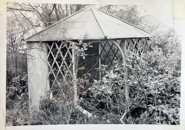
Slide - Former Summerhouse in the Garden of 'Reno', St John 's Parade, 1977
... The MMBW Detail Plan No.1576 (1904) shows the remaining portion of the original land holding, including a semi-circular pathway at the front, and garden features such as an aviary, a fountain and grotto, and a fernery. The garden including rare plants supplied by Baron Von Mueller, surrounds the cottage in a tangled frenzy. ...The MMBW Detail Plan No.1576 (1904) shows the remaining portion of the original land holding, including a semi-circular pathway at the front, and garden features such as an aviary, a fountain and grotto, and a fernery. The garden including rare plants supplied by Baron Von Mueller, surrounds the cottage in a tangled frenzy. ...‘Reno’, stood on the east side of St John’s Parade. Its earliest recorded owner was the architect Samuel Cocking who lived there from c.1865 until his death in 1888. The original landholding was bordered by Cotham Road, Glenferrie Road, Wellington Street, and Charles Street. The southern portion of this land included a fine orchard, with many imported trees. The old summer house, at first in the orchard, was later removed to the house garden. The MMBW Detail Plan No.1576 (1904) shows the remaining portion of the original land holding, including a semi-circular pathway at the front, and garden features such as an aviary, a fountain and grotto, and a fernery. The garden including rare plants supplied by Baron Von Mueller, surrounds the cottage in a tangled frenzy. Despite a ‘local significance’ classification by the National Trust, the house was demolished in 1977.Rare photograph of an historically important weatherboard cottage in St John's Parade.Colour positive transparency (slide) of the former summerhouse in the garden of 'Reno' in St John's Parade, Kew (demolished 1977). historic houses -- kew (vic.), reno -- st john's parade -- kew (vic.) -
 Kew Historical Society Inc
Slide - 'Reno', St John 's Parade, 1977
... The MMBW Detail Plan No.1576 (1904) shows the remaining portion of the original land holding, including a semi-circular pathway at the front, and garden features such as an aviary, a fountain and grotto, and a fernery. The garden including rare plants supplied by Baron Von Mueller, surrounds the cottage in a tangled frenzy. ...The MMBW Detail Plan No.1576 (1904) shows the remaining portion of the original land holding, including a semi-circular pathway at the front, and garden features such as an aviary, a fountain and grotto, and a fernery. The garden including rare plants supplied by Baron Von Mueller, surrounds the cottage in a tangled frenzy. ...‘Reno’, stood on the east side of St John’s Parade. Its earliest recorded owner was the architect Samuel Cocking who lived there from c.1865 until his death in 1888. The original landholding was bordered by Cotham Road, Glenferrie Road, Wellington Street, and Charles Street. The southern portion of this land included a fine orchard, with many imported trees. The old summer house, at first in the orchard, was later removed to the house garden. The MMBW Detail Plan No.1576 (1904) shows the remaining portion of the original land holding, including a semi-circular pathway at the front, and garden features such as an aviary, a fountain and grotto, and a fernery. The garden including rare plants supplied by Baron Von Mueller, surrounds the cottage in a tangled frenzy. Despite a ‘local significance’ classification by the National Trust, the house was demolished in 1977.Rare photograph of an historically important weatherboard cottage in St John's Parade.Colour positive transparency (slide) of the garden of 'Reno' in St John's Parade, Kew (demolished 1977). historic houses -- kew (vic.), reno -- st john's parade -- kew (vic.) -
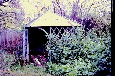
 Kew Historical Society Inc
Slide - Former Summerhouse in the Garden of 'Reno', St John 's Parade, 1977
... The MMBW Detail Plan No.1576 (1904) shows the remaining portion of the original land holding, including a semi-circular pathway at the front, and garden features such as an aviary, a fountain and grotto, and a fernery. The garden including rare plants supplied by Baron Von Mueller, surrounds the cottage in a tangled frenzy. ...The MMBW Detail Plan No.1576 (1904) shows the remaining portion of the original land holding, including a semi-circular pathway at the front, and garden features such as an aviary, a fountain and grotto, and a fernery. The garden including rare plants supplied by Baron Von Mueller, surrounds the cottage in a tangled frenzy. ...‘Reno’, stood on the east side of St John’s Parade. Its earliest recorded owner was the architect Samuel Cocking who lived there from c.1865 until his death in 1888. The original landholding was bordered by Cotham Road, Glenferrie Road, Wellington Street, and Charles Street. The southern portion of this land included a fine orchard, with many imported trees. The old summer house, at first in the orchard, was later removed to the house garden. The MMBW Detail Plan No.1576 (1904) shows the remaining portion of the original land holding, including a semi-circular pathway at the front, and garden features such as an aviary, a fountain and grotto, and a fernery. The garden including rare plants supplied by Baron Von Mueller, surrounds the cottage in a tangled frenzy. Despite a ‘local significance’ classification by the National Trust, the house was demolished in 1977.Rare photograph of an historically important weatherboard cottage in St John's Parade.Colour positive transparency (slide) of the former summerhouse in the garden of 'Reno' in St John's Parade, Kew (demolished 1977). historic houses -- kew (vic.), reno -- st john's parade -- kew (vic.) -
 Kew Historical Society Inc
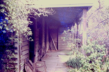
Photograph - 'Reno', 10 St John's Parade, John T Collins, 1977
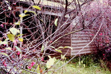
... The MMBW Detail Plan No.1576 (1904) shows the remaining portion of the original land holding, including a semi-circular pathway at the front, and garden features such as an aviary, a fountain and grotto, and a fernery. The garden including rare plants supplied by Baron Von Mueller, surrounds the cottage in a tangled frenzy. ...The MMBW Detail Plan No.1576 (1904) shows the remaining portion of the original land holding, including a semi-circular pathway at the front, and garden features such as an aviary, a fountain and grotto, and a fernery. The garden including rare plants supplied by Baron Von Mueller, surrounds the cottage in a tangled frenzy. ...‘Reno’, stood on the east side of St John’s Parade. Its earliest recorded owner was the architect Samuel Cocking who lived there from c.1865 until his death in 1888. The original landholding was bordered by Cotham Road, Glenferrie Road, Wellington Street, and Charles Street. The southern portion of this land included a fine orchard, with many imported trees. The old summer house, at first in the orchard, was later removed to the house garden. The MMBW Detail Plan No.1576 (1904) shows the remaining portion of the original land holding, including a semi-circular pathway at the front, and garden features such as an aviary, a fountain and grotto, and a fernery. The garden including rare plants supplied by Baron Von Mueller, surrounds the cottage in a tangled frenzy. Despite a ‘local significance’ classification by the National Trust, the house was demolished in 1977.Partial view, north side of the weatherboard cottage in St John's Parade, Kew, known as 'Reno' (demolished 1977). Architectural elements revealed in this photo by John T Collins include: two wing, hip roof construction; external buildings at angles to main wing; corrugated iron roofing [over shingles]; brick chimney external to building; unvarnished/unpainted external weatherboards. General dilapidated condition. "Kew 'Reno' 10 St Johns Pde / John Collins, 11 Anderson Road, Hawthorn East, 3123, Film 35B Exposure 27"reno - st john's parade -- kew (vic.), john t collins -
 Kew Historical Society Inc
Photograph - 'Reno', 10 St John's Parade, John T Collins, 1977
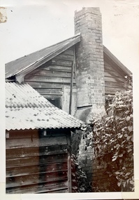
... The MMBW Detail Plan No.1576 (1904) shows the remaining portion of the original land holding, including a semi-circular pathway at the front, and garden features such as an aviary, a fountain and grotto, and a fernery. The garden including rare plants supplied by Baron Von Mueller, surrounds the cottage in a tangled frenzy. ...The MMBW Detail Plan No.1576 (1904) shows the remaining portion of the original land holding, including a semi-circular pathway at the front, and garden features such as an aviary, a fountain and grotto, and a fernery. The garden including rare plants supplied by Baron Von Mueller, surrounds the cottage in a tangled frenzy. ...‘Reno’, stood on the east side of St John’s Parade. Its earliest recorded owner was the architect Samuel Cocking who lived there from c.1865 until his death in 1888. The original landholding was bordered by Cotham Road, Glenferrie Road, Wellington Street, and Charles Street. The southern portion of this land included a fine orchard, with many imported trees. The old summer house, at first in the orchard, was later removed to the house garden. The MMBW Detail Plan No.1576 (1904) shows the remaining portion of the original land holding, including a semi-circular pathway at the front, and garden features such as an aviary, a fountain and grotto, and a fernery. The garden including rare plants supplied by Baron Von Mueller, surrounds the cottage in a tangled frenzy. Despite a ‘local significance’ classification by the National Trust, the house was demolished in 1977.Partial view, side of the weatherboard cottage in St John's Parade, Kew, known as 'Reno' (demolished 1977). Architectural elements revealed in this photo by John T Collins include: hip roof construction; corrugated iron roofing [over shingles]; unvarnished/unpainted external weatherboards; Externally opening 1860s-style casement window. General dilapidated condition. "Kew 'Reno' 10 St Johns Pde / John Collins, 11 Anderson Road, Hawthorn East, 3123, Film 35B Exposure 26"reno - st john's parade -- kew (vic.), john t collins -
 Kew Historical Society Inc
Photograph - 'Reno', 10 St John's Parade, John T Collins, 1977
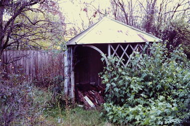
... The MMBW Detail Plan No.1576 (1904) shows the remaining portion of the original land holding, including a semi-circular pathway at the front, and garden features such as an aviary, a fountain and grotto, and a fernery. The garden including rare plants supplied by Baron Von Mueller, surrounds the cottage in a tangled frenzy. ...The MMBW Detail Plan No.1576 (1904) shows the remaining portion of the original land holding, including a semi-circular pathway at the front, and garden features such as an aviary, a fountain and grotto, and a fernery. The garden including rare plants supplied by Baron Von Mueller, surrounds the cottage in a tangled frenzy. ...‘Reno’, stood on the east side of St John’s Parade. Its earliest recorded owner was the architect Samuel Cocking who lived there from c.1865 until his death in 1888. The original landholding was bordered by Cotham Road, Glenferrie Road, Wellington Street, and Charles Street. The southern portion of this land included a fine orchard, with many imported trees. The old summer house, at first in the orchard, was later removed to the house garden. The MMBW Detail Plan No.1576 (1904) shows the remaining portion of the original land holding, including a semi-circular pathway at the front, and garden features such as an aviary, a fountain and grotto, and a fernery. The garden including rare plants supplied by Baron Von Mueller, surrounds the cottage in a tangled frenzy. Despite a ‘local significance’ classification by the National Trust, the house was demolished in 1977.Side of the original, relocated summer house of 'Reno' at 10 St John's Parade, Kew, (demolished 1977). Architectural elements revealed in this photo by John T Collins include: four-sided construction; trellis and weatherboard walls; corrugated iron roofing. Re-use as woodshed. General dilapidated condition. "Kew 'Reno' 10 St Johns Pde / John Collins, 11 Anderson Road, Hawthorn East, 3123, Film 35B Exposure 24"reno - st john's parade -- kew (vic.), john t collins -
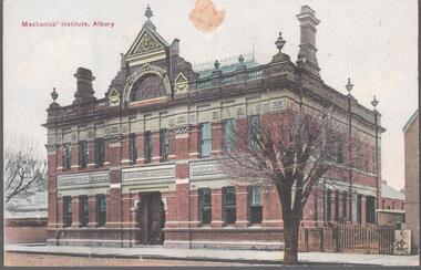 Bendigo Historical Society Inc.
Postcard - Elliot Postcard Collection: Australia, 1895 - 1914
... Augustine, Yass 1405.073 The Grotto, Church of St. Augustine, Yass 1405.074 Hume and Hovell Monument 1405.075 Flat Rock, Middle Harbour, Sydney 1405.076 the Dam, National Park, New South Wales 1405.077 Hamilton Hume's Monument, Albury Gardens 1405.078 The weir, Yass 1405.079 Lane Cove River, Sydney, N.S.W. 1405.080 Suspension Bridge, North Sydney...Augustine, Yass 1405.073 The Grotto, Church of St. Augustine, Yass 1405.074 Hume and Hovell Monument 1405.075 Flat Rock, Middle Harbour, Sydney 1405.076 the Dam, National Park, New South Wales 1405.077 Hamilton Hume's Monument, Albury Gardens 1405.078 The weir, Yass 1405.079 Lane Cove River, Sydney, N.S.W. 1405.080 Suspension Bridge, North Sydney Postcard Elliot Postcard Collection: Australia ...Thought to have originated in Austria in 1869, postcards first gained popularity in Australia in the 1890s.They were used to send short messages to friends and family. This collection was generated by Mary Emma Elliot of Talgarno. Talgarno is a rural locality in Victoria, Australia, situated on the southern shoreline of Lake Hume, about 23 km east of Albury-Wodonga. The collection contains postcards from across the world. Mary Emma Sibley was born in Ironbark, Bendigo in 1859. She married James Elliot in 1893 and they settled at “Kelso”, Talgarno. They had two children – Mona and Sibley. Mary Emma Elliot died in Melbourne in 1944, aged 84 years. Twenty Australian postcards collected by Mrs. James Elliot between 1898 and 1915. 1405.061 Mechanic's Institute, Albury 1405.062 Kiama, N.S.W. 1405.063 Dean Street, Albury, N.S.W. 1405.064 Union Bank and Post Office, Temora 1405.065 Middle Harbour, Sydney 1405.066 Sydney University, Sydney 1405.067 Botanic Gardens, Sydney 1405.068 Bridge Street, Sydney 1405.069 Botanic Gardens, Sydney 1405.070 The Two Bridges, Yass 1405.071 Court house, Yass 1405.072 Church of St. Augustine, Yass 1405.073 The Grotto, Church of St. Augustine, Yass 1405.074 Hume and Hovell Monument 1405.075 Flat Rock, Middle Harbour, Sydney 1405.076 the Dam, National Park, New South Wales 1405.077 Hamilton Hume's Monument, Albury Gardens 1405.078 The weir, Yass 1405.079 Lane Cove River, Sydney, N.S.W. 1405.080 Suspension Bridge, North Sydneypostcards, collecting, collections, talgarno -
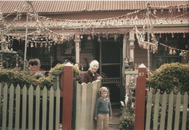 Kew Historical Society Inc
Photograph - Grace Tabulo, 'Fairyland', 57 Malmsbury Street, c.1963
... Many a wedding present, succumbed at last to the ravages of time, holds a vantage spot in the grotto. The children bring along their broken bits and each is found a spot and cemented into the fairy story picture. ...Many a wedding present, succumbed at last to the ravages of time, holds a vantage spot in the grotto. The children bring along their broken bits and each is found a spot and cemented into the fairy story picture. ...Mr. and Mrs. Tabulo, who owned the house between 1945 and 1965, created Fairyland in the 1940s. Fairyland was open to the public, especially children, who were invited to write their names in visitors’ books. These are now in the possession of the Kew Historical Society. Following the sale of the house after Mrs. Tabulo’s death, the garden and content of the house was cleared of its previous adornments. Grace Tabulo died in 1965. "CHILDREN LIVING IN THE ONE STREET soon find out which house will welcome them and which house to avoid. Few children in few streets have ever had such a find as those who live in Malmsbury st, Kew. At 56 Malmsbury st they all belong. It is their house. There are no young children who are actual residents, but they are to be found there all day long. Mrs J. Tabulo is chatelaine of 56, but few children know her by this name. To them she she is the Fairyland Lady. In her pocket handkerchief front garden there are few flowers; there isn't room, for it has been turned into a children's dream. Cement, tiles, old broken pieces of priceless china, miniature bottles, leadlights, and strange and beautiful little statues have been welded into a grotto which Mrs Tabulo says is only appreciated and understandable to children. It started off in a small way three years ago with a few odd statuettes, but with a street full of children ready and eager to build, it now has hardly room for even a miniature. Like the children, the Fairyland Lady knows and values each mosaic-like piece. Many a wedding present, succumbed at last to the ravages of time, holds a vantage spot in the grotto. The children bring along their broken bits and each is found a spot and cemented into the fairy story picture. In the cottage itself the children are also welcome. There is no spot, from skirting board to ceiling, that is not crowned with some gem or another. Fans, plaques, and china, some of it more than 300 years old, is handled daily by tiny but careful hands. "Children," said Mrs Tabulo, "should be allowed to love and handle beautiful things. They are much more careful than adults. Bless them!" -H.S (The Argus, 22 January 1949)A photograph of Mrs. Grace Tabulo in the garden of ‘Fairyland’ in 57 Malmsbury Street, Kew. fairyland, malmsbury street, kew, tabulo, grace tabulo -
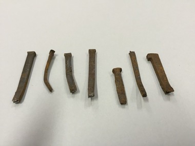 Kew Historical Society Inc
Functional object - Wrought iron nails from 'Reno', St John's Parade, c. 1864
... The MMBW Detail Plan No.1576 (1904) shows the remaining portion of the original land holding, including a semi-circular pathway at the front, and garden features such as an aviary, a fountain and grotto, and a fernery. None of these are apparent in photographs dating from the 1960s, where the garden, which once included rare plants provided by Baron Von Mueller, surrounds the cottage in a tangled frenzy. ...The MMBW Detail Plan No.1576 (1904) shows the remaining portion of the original land holding, including a semi-circular pathway at the front, and garden features such as an aviary, a fountain and grotto, and a fernery. None of these are apparent in photographs dating from the 1960s, where the garden, which once included rare plants provided by Baron Von Mueller, surrounds the cottage in a tangled frenzy. ...Comparatively few weatherboard houses in Kew survived from the early years of settlement into the second half of the 20th century. One such property was ‘Reno’, which once stood on the east side of St John’s Parade. Its earliest recorded owner was the architect Samuel Cocking who lived there from c.1865 until his death in 1888. The original landholding was bordered by Cotham Road, Glenferrie Road, Wellington Street, and Charles Street. The southern portion of this land included a fine orchard, with many imported trees. The old summer house, at first in the orchard, was later removed to the house garden. The MMBW Detail Plan No.1576 (1904) shows the remaining portion of the original land holding, including a semi-circular pathway at the front, and garden features such as an aviary, a fountain and grotto, and a fernery. None of these are apparent in photographs dating from the 1960s, where the garden, which once included rare plants provided by Baron Von Mueller, surrounds the cottage in a tangled frenzy. Despite a ‘local significance’ classification by the National Trust, the house was demolished in 1977.7 square headed iron nails collected from Reno before its demolition. In envelope marked with the name Joy Stewartreno, nails, samuel cocking -
![Wallpaper from 'Reno', St John's Parade [Kew]](/media/collectors/550653872162f11fb04854aa/items/57975996d0cdd1098c81d980/item-media/579759ded0cdd1098c81f6fa/item-fit-380x285.jpg?cb=6) Kew Historical Society Inc
Kew Historical Society IncDecorative object - Wallpaper sample from 'Reno', St John's Parade, 1890s
... The MMBW Detail Plan No.1576 (1904) shows the remaining portion of the original land holding, including a semi-circular pathway at the front, and garden features such as an aviary, a fountain and grotto, and a fernery. None of these are apparent in photographs dating from the 1960s, where the garden, which once included rare plants provided by Baron Von Mueller, surrounds the cottage in a tangled frenzy. ...The MMBW Detail Plan No.1576 (1904) shows the remaining portion of the original land holding, including a semi-circular pathway at the front, and garden features such as an aviary, a fountain and grotto, and a fernery. None of these are apparent in photographs dating from the 1960s, where the garden, which once included rare plants provided by Baron Von Mueller, surrounds the cottage in a tangled frenzy. ...Comparatively few weatherboard houses in Kew survived from the early years of settlement into the second half of the 20th century. One such property was ‘Reno’, which once stood on the east side of St John’s Parade. Its earliest recorded owner was the architect Samuel Cocking who lived there from c.1865 until his death in 1888. The original landholding was bordered by Cotham Road, Glenferrie Road, Wellington Street, and Charles Street. The southern portion of this land included a fine orchard, with many imported trees. The old summer house, at first in the orchard, was later removed to the house garden. The MMBW Detail Plan No.1576 (1904) shows the remaining portion of the original land holding, including a semi-circular pathway at the front, and garden features such as an aviary, a fountain and grotto, and a fernery. None of these are apparent in photographs dating from the 1960s, where the garden, which once included rare plants provided by Baron Von Mueller, surrounds the cottage in a tangled frenzy. Despite a ‘local significance’ classification by the National Trust, the house was demolished in 1977. Wallpaper fragment from ‘Reno’. This small fragment of floral wall paper is a bolder design than the delicately drawn flowers in 1977.0005.1. The flowers in this example were impressionistically created using printing blocks that allowed for different thicknesses of paint to be applied in the hand-blocking process. wallpaper, reno, st john's parade, kew -
![Wallpaper from 'Reno', St John's Parade [Kew]](/media/collectors/550653872162f11fb04854aa/items/57975a62d0cdd1098c8232a8/item-media/57975cabd0cdd1098c836f91/item-fit-380x285.jpg?cb=6) Kew Historical Society Inc
Kew Historical Society IncDecorative object - Wallpaper sample from 'Reno', St John's Parade, 1870s
... The MMBW Detail Plan No.1576 (1904) shows the remaining portion of the original land holding, including a semi-circular pathway at the front, and garden features such as an aviary, a fountain and grotto, and a fernery. None of these are apparent in photographs dating from the 1960s, where the garden, which once included rare plants provided by Baron Von Mueller, surrounds the cottage in a tangled frenzy. ...The MMBW Detail Plan No.1576 (1904) shows the remaining portion of the original land holding, including a semi-circular pathway at the front, and garden features such as an aviary, a fountain and grotto, and a fernery. None of these are apparent in photographs dating from the 1960s, where the garden, which once included rare plants provided by Baron Von Mueller, surrounds the cottage in a tangled frenzy. ...Comparatively few weatherboard houses in Kew survived from the early years of settlement into the second half of the 20th century. One such property was ‘Reno’, which once stood on the east side of St John’s Parade. Its earliest recorded owner was the architect Samuel Cocking who lived there from c.1865 until his death in 1888. The original landholding was bordered by Cotham Road, Glenferrie Road, Wellington Street, and Charles Street. The southern portion of this land included a fine orchard, with many imported trees. The old summer house, at first in the orchard, was later removed to the house garden. The MMBW Detail Plan No.1576 (1904) shows the remaining portion of the original land holding, including a semi-circular pathway at the front, and garden features such as an aviary, a fountain and grotto, and a fernery. None of these are apparent in photographs dating from the 1960s, where the garden, which once included rare plants provided by Baron Von Mueller, surrounds the cottage in a tangled frenzy. Despite a ‘local significance’ classification by the National Trust, the house was demolished in 1977.Wallpaper fragment from ‘Reno’. This large single example is interesting as it represents a change in fashion and style from the finely drawn flowers (1971.0002.1) of an older paper, parts of which can be seen behind this sample. Typically the updating of wallpapers was accomplished by laying a new paper over the old. The ‘newer’ wallpaper is of a single colour, the tone of which may have suffered from colour distortion due to ageing. The new block-printed design, featuring repeated sprays of flowers and leaves combines a bold use of colour with an elegance of design.reno, st john's parade, kew, samuel cocking, wallpaper -
![Wallpaper fragment - Reno, St John's Parade [Kew]](/media/collectors/550653872162f11fb04854aa/items/57975cd6d0cdd1098c838ddb/item-media/57975d42d0cdd1098c83c222/item-fit-380x285.jpg?cb=6) Kew Historical Society Inc
Kew Historical Society IncDecorative object - Wallpaper sample from 'Reno', St John's Parade, 1870s
... The MMBW Detail Plan No.1576 (1904) shows the remaining portion of the original land holding, including a semi-circular pathway at the front, and garden features such as an aviary, a fountain and grotto, and a fernery. None of these are apparent in photographs dating from the 1960s, where the garden, which once included rare plants provided by Baron Von Mueller, surrounds the cottage in a tangled frenzy. ...The MMBW Detail Plan No.1576 (1904) shows the remaining portion of the original land holding, including a semi-circular pathway at the front, and garden features such as an aviary, a fountain and grotto, and a fernery. None of these are apparent in photographs dating from the 1960s, where the garden, which once included rare plants provided by Baron Von Mueller, surrounds the cottage in a tangled frenzy. ...Comparatively few weatherboard houses in Kew survived from the early years of settlement into the second half of the 20th century. One such property was ‘Reno’, which once stood on the east side of St John’s Parade. Its earliest recorded owner was the architect Samuel Cocking who lived there from c.1865 until his death in 1888. The original landholding was bordered by Cotham Road, Glenferrie Road, Wellington Street, and Charles Street. The southern portion of this land included a fine orchard, with many imported trees. The old summer house, at first in the orchard, was later removed to the house garden. The MMBW Detail Plan No.1576 (1904) shows the remaining portion of the original land holding, including a semi-circular pathway at the front, and garden features such as an aviary, a fountain and grotto, and a fernery. None of these are apparent in photographs dating from the 1960s, where the garden, which once included rare plants provided by Baron Von Mueller, surrounds the cottage in a tangled frenzy. Despite a ‘local significance’ classification by the National Trust, the house was demolished in 1977. Wallpaper fragment from ‘Reno’. These three boldly designed samples from a single room are in shades of green and brown, highlighted by yellow and red floral sprays. While more accurately printed and coloured, the fragment lacks the freedom of design of the earlier samples.wallpaper, reno, st john's parade, kew, samuel cocking -
![Reno, St John's Parade [Kew] - Reno, St John's Parade [Kew]](/media/collectors/550653872162f11fb04854aa/items/57975dcbd0cdd1098c840aaf/item-media/57975e31d0cdd1098c84343d/item-fit-380x285.jpg?cb=6) Kew Historical Society Inc
Kew Historical Society IncDecorative object - Wallpaper samples from 'Reno', St John's Parade, 1880-1910
... The MMBW Detail Plan No.1576 (1904) shows the remaining portion of the original land holding, including a semi-circular pathway at the front, and garden features such as an aviary, a fountain and grotto, and a fernery. None of these are apparent in photographs dating from the 1960s, where the garden, which once included rare plants provided by Baron Von Mueller, surrounds the cottage in a tangled frenzy. ...The MMBW Detail Plan No.1576 (1904) shows the remaining portion of the original land holding, including a semi-circular pathway at the front, and garden features such as an aviary, a fountain and grotto, and a fernery. None of these are apparent in photographs dating from the 1960s, where the garden, which once included rare plants provided by Baron Von Mueller, surrounds the cottage in a tangled frenzy. ...Comparatively few weatherboard houses in Kew survived from the early years of settlement into the second half of the 20th century. One such property was ‘Reno’, which once stood on the east side of St John’s Parade. Its earliest recorded owner was the architect Samuel Cocking who lived there from c.1865 until his death in 1888. The original landholding was bordered by Cotham Road, Glenferrie Road, Wellington Street, and Charles Street. The southern portion of this land included a fine orchard, with many imported trees. The old summer house, at first in the orchard, was later removed to the house garden. The MMBW Detail Plan No.1576 (1904) shows the remaining portion of the original land holding, including a semi-circular pathway at the front, and garden features such as an aviary, a fountain and grotto, and a fernery. None of these are apparent in photographs dating from the 1960s, where the garden, which once included rare plants provided by Baron Von Mueller, surrounds the cottage in a tangled frenzy. Despite a ‘local significance’ classification by the National Trust, the house was demolished in 1977.Wallpaper fragment from ‘Reno’. These two large fragments of wallpaper have a formality of design that is accentuated by the wide borders and narrow vertical lines that separate the repeated designs of rose garlands in vases on a vertical trellis design. The design is in tones of pink and green with gilding.reno, st john's parade, kew, samuel cocking, wallpaper