Showing 85 items matching "groyne"
-
 Ballarat Heritage Services
Photograph, Clare Gervasoni, Apollo Bay, Victoria, 24/01/2022
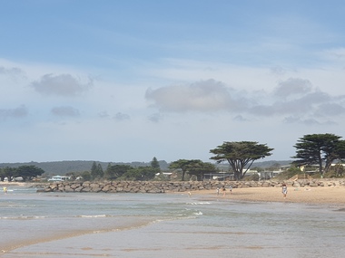
... ...groyne...In 2021, the Department of Environment, Land, Water and Planning (DELWP) constructed two new groynes and a section of rock seawall at Apollo Bay to help manage the impacts of coastal erosion. ...Colour photograph of a coastal scene at Apollo Bay, featuring new rock groynes to protect the Great Ocean Road from erosion. ...Apollo bay beach coast groyne rockwall Colour photograph of a coastal scene at Apollo Bay, featuring new rock groynes to protect the Great Ocean Road from erosion. ...In 2021, the Department of Environment, Land, Water and Planning (DELWP) constructed two new groynes and a section of rock seawall at Apollo Bay to help manage the impacts of coastal erosion. The new 70-meter-long rock groynes run perpendicular to the shoreline and be located just south of the Milford St revetment and to the south of Milford Creek. Sections of rock seawall will be constructed between the two Groynes with an aim to protect the dune, walking path, cypress trees and road from erosion. Colour photograph of a coastal scene at Apollo Bay, featuring new rock groynes to protect the Great Ocean Road from erosion. apollo bay, beach, coast, groyne, rockwall -
 Ballarat Heritage Services
Photograph, Clare Gervasoni, Apollo Bay, Victoria, 24/01/2022
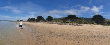
... ...groyne...In 2021, the Department of Environment, Land, Water and Planning (DELWP) constructed two new groynes and a section of rock seawall at Apollo Bay to help manage the impacts of coastal erosion. ...Colour photograph of a coastal scene at Apollo Bay, featuring new rock wall and groynes to protect the Great Ocean Road from erosion. ...Apollo bay beach coast groyne rockwall Colour photograph of a coastal scene at Apollo Bay, featuring new rock wall and groynes to protect the Great Ocean Road from erosion. ...In 2021, the Department of Environment, Land, Water and Planning (DELWP) constructed two new groynes and a section of rock seawall at Apollo Bay to help manage the impacts of coastal erosion. The new 70-meter-long rock groynes run perpendicular to the shoreline and be located just south of the Milford St revetment and to the south of Milford Creek. Sections of rock seawall will be constructed between the two Groynes with an aim to protect the dune, walking path, cypress trees and road from erosion. Colour photograph of a coastal scene at Apollo Bay, featuring new rock wall and groynes to protect the Great Ocean Road from erosion. apollo bay, beach, coast, groyne, rockwall -
 Ballarat Heritage Services
Photograph, Clare Gervasoni, Sea Wall at Apollo Bay, Victoria, 24/01/2022
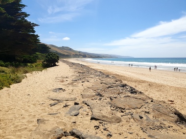
... ...groyne...In 2021, the Department of Environment, Land, Water and Planning (DELWP) constructed two new groynes and a section of rock seawall at Apollo Bay to help manage the impacts of coastal erosion. ...Colour photograph of a coastal scene at Apollo Bay, featuring new rock wall and groynes to protect the Great Ocean Road from erosion. ...Apollo bay beach coast groyne rockwall sea wall Colour photograph of a coastal scene at Apollo Bay, featuring new rock wall and groynes to protect the Great Ocean Road from erosion. ...In 2021, the Department of Environment, Land, Water and Planning (DELWP) constructed two new groynes and a section of rock seawall at Apollo Bay to help manage the impacts of coastal erosion. The new 70-meter-long rock groynes run perpendicular to the shoreline and be located just south of the Milford St revetment and to the south of Milford Creek. Sections of rock seawall will be constructed between the two Groynes with an aim to protect the dune, walking path, cypress trees and road from erosion. Colour photograph of a coastal scene at Apollo Bay, featuring new rock wall and groynes to protect the Great Ocean Road from erosion. apollo bay, beach, coast, groyne, rockwall, sea wall -
 Ballarat Heritage Services
Photograph, Clare Gervasoni, Sea Wall at Apollo Bay, Victoria, 24/01/2022
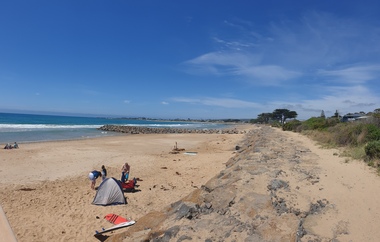
... ...groyne...In 2021, the Department of Environment, Land, Water and Planning (DELWP) constructed two new groynes and a section of rock seawall at Apollo Bay to help manage the impacts of coastal erosion. ...Colour photograph of a coastal scene at Apollo Bay, featuring new rock wall and groynes to protect the Great Ocean Road from erosion. ...Apollo bay beach coast groyne rockwall sea wall Colour photograph of a coastal scene at Apollo Bay, featuring new rock wall and groynes to protect the Great Ocean Road from erosion. ...In 2021, the Department of Environment, Land, Water and Planning (DELWP) constructed two new groynes and a section of rock seawall at Apollo Bay to help manage the impacts of coastal erosion. The new 70-meter-long rock groynes run perpendicular to the shoreline and be located just south of the Milford St revetment and to the south of Milford Creek. Sections of rock seawall will be constructed between the two Groynes with an aim to protect the dune, walking path, cypress trees and road from erosion. Colour photograph of a coastal scene at Apollo Bay, featuring new rock wall and groynes to protect the Great Ocean Road from erosion. apollo bay, beach, coast, groyne, rockwall, sea wall -
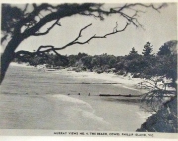 Phillip Island and District Historical Society Inc.
Photograph, Murray Views, Cowes East Beach
... Groynes were erected to help with erosion on the beach....Small black and white photo of the beach to the east of Cowes, showing groynes....Phillip Island and District Historical Society Inc. phillip-island-and-the-bass-coast Groynes were erected to help with erosion on the beach. ...Groynes were erected to help with erosion on the beach.Small black and white photo of the beach to the east of Cowes, showing groynes. Murray Views No. 4 The Beach Cowes, Phillip Island, Vicphotographs, cowes, cowes beach, erosion, postcards -
 Glenelg Shire Council Cultural Collection
Photograph, 1980
... Black and white photo showing two rock groynes on Dutton Way...Back: 4pm 14/10/80 Tide to 4m View East from near Maretimo Gates Showing Groynes ---Pencil...Glenelg Shire Council Cultural Collection History House Cliff Street Portland great-ocean-road Port of Portland Authority Archives Port of Portland Back: 4pm 14/10/80 Tide to 4m View East from near Maretimo Gates Showing Groynes ---Pencil Black and white photo showing two rock groynes on Dutton Way Photograph Photograph ...Port of Portland Authority ArchivesBack: 4pm 14/10/80 Tide to 4m View East from near Maretimo Gates Showing Groynes ---Pencilport of portland -
Glenelg Shire Council Cultural Collection
Photograph, Photograph - Dredging, 1953
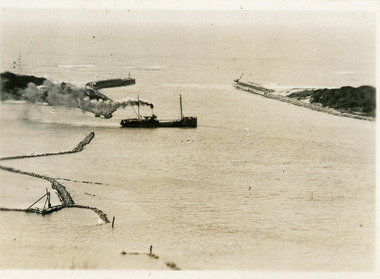
... Black and white photo showing the dredger outlet pipe on the groyne, discharging material into sea....Back: Purple PHT Stamp. 7/18 - Black ink. 27/7/53 - Dredger outlet on groyne - Blue ink....Glenelg Shire Council Cultural Collection History House Cliff Street Portland great-ocean-road Port of Portland Authority Archives Port of Portland Back: Purple PHT Stamp. 7/18 - Black ink. 27/7/53 - Dredger outlet on groyne - Blue ink. Black and white photo showing the dredger outlet pipe on the groyne, discharging material into sea. ...Port of Portland Authority ArchivesBack: Purple PHT Stamp. 7/18 - Black ink. 27/7/53 - Dredger outlet on groyne - Blue ink.port of portland -
 Port Fairy Historical Society Museum and Archives
Photograph
... ...groyne... East Beach Groyne walls...Port Fairy Historical Society Museum and Archives 30 Gipps Street Port Fairy great-ocean-road East Beach Groyne walls East beach groyne dune sea ocean Photograph Photograph ...East Beach Groyne wallseast beach, groyne, dune, sea, ocean -
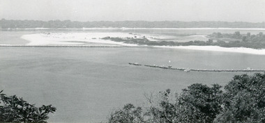
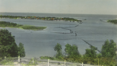
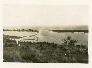
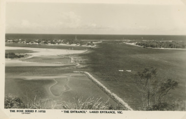 Lakes Entrance Historical Society
Postcard - Gippsland Lakes, Rose Stereograph Co Armidale Vic, The Entrance Lakes Entrance viewed from Jemmys Point, 1940 c
... emmys Point showing the Entrance, groynes at the entrance to North Arm and around Bullock Island and portion of New Works area. ...Black and white postcard taken from Jemmys Point showing the Entrance, groynes at the entrance to North Arm and around Bullock Island and portion of New Works area. ...Lakes Entrance Historical Society 4 Marine Parade Lakes Entrance gippsland emmys Point showing the Entrance, groynes at the entrance to North Arm and around Bullock Island and portion of New Works area. ...emmys Point showing the Entrance, groynes at the entrance to North Arm and around Bullock Island and portion of New Works area. Two small boats moored in main channel Lakes Entrance Victoria Black and white postcard taken from Jemmys Point showing the Entrance, groynes at the entrance to North Arm and around Bullock Island and portion of New Works area. Two small boats moored in main channel Lakes Entrance Victoria P10722The Entrance Lakes Entrance Victoria waterways, gippsland lakes, gippsland ports -
Glenelg Shire Council Cultural Collection
Photograph - Photograph - Dutton Way, n.d
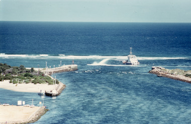
... Coloured aerial photo of Dutton Way, Showing the rock wall and groynes...Glenelg Shire Council Cultural Collection History House Cliff Street Portland great-ocean-road Port of Portland Authority Archieves Coloured aerial photo of Dutton Way, Showing the rock wall and groynes Photograph Photograph - Dutton Way ...Port of Portland Authority ArchievesColoured aerial photo of Dutton Way, Showing the rock wall and groynes -
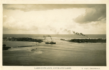 Lakes Entrance Historical Society
Postcard - SS Wyrallah, SS Manawatu, c1920
... Black and white postcard showing view of the Entrance, with SS Manuwatu and SS Wyrallah at sea, timber entrance groynes visible, rock and timber groynes to form Bullock Island visible. ...Lakes Entrance Historical Society 4 Marine Parade Lakes Entrance gippsland Also other copies purchased Ships and Shipping Jetties Waterways Black and white postcard showing view of the Entrance, with SS Manuwatu and SS Wyrallah at sea, timber entrance groynes visible, rock and timber groynes to form Bullock Island visible. ...Also other copies purchasedBlack and white postcard showing view of the Entrance, with SS Manuwatu and SS Wyrallah at sea, timber entrance groynes visible, rock and timber groynes to form Bullock Island visible. Lakes Entrance Victoriaships and shipping, jetties, waterways -
 Lakes Entrance Historical Society
Photograph - Rigby Island, 1955c
... Black and white photograph showing east end of Rigby Island, sand build up on Snake Island and rock groynes at Lakes Entrance, Victoria. Shrubbery in foreground, rock groynes in Reeves Channel, sand dunes in background....Lakes Entrance Historical Society 4 Marine Parade Lakes Entrance gippsland Waterways Ocean Islands Black and white photograph showing east end of Rigby Island, sand build up on Snake Island and rock groynes at Lakes Entrance, Victoria. Shrubbery in foreground, rock groynes in Reeves Channel, sand dunes in background. ...Black and white photograph showing east end of Rigby Island, sand build up on Snake Island and rock groynes at Lakes Entrance, Victoria. Shrubbery in foreground, rock groynes in Reeves Channel, sand dunes in background.waterways, ocean, islands -
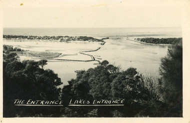
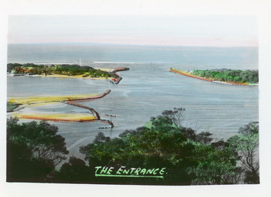 Lakes Entrance Historical Society
Postcard - The Entrance, Bulmer H D, 1940c
... It shows the rock groynes at Bullock Island with dredged sand filling the basin between island and groyne. ...It shows the rock groynes at Bullock Island with dredged sand filling the basin between island and groyne. ...Hand tinted small format postcard of the entrance to the Gippsland Lakes, taken from Jemmys Point. It shows the rock groynes at Bullock Island with dredged sand filling the basin between island and groyne. Lakes Entrance VictoriaThe Entranceislands, waterways, topography -
 Lakes Entrance Historical Society
Photograph - Snake Island, 1990c
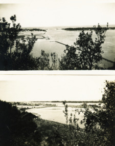
... Colour photograph showing sand dunes, Snake Island and rock groynes, Lakes Entrance, Victoria....Waterways Islands Vegetation Colour photograph showing sand dunes, Snake Island and rock groynes, Lakes Entrance, Victoria. Photograph Snake Island ...This is the before paired photograph used in the 150 year, Lakes Entrance 1858-2008 display.|The after paired photograph number is 01666.1|Also one 12 x 16 framed photograph used in room display.Colour photograph showing sand dunes, Snake Island and rock groynes, Lakes Entrance, Victoria.waterways, islands, vegetation -
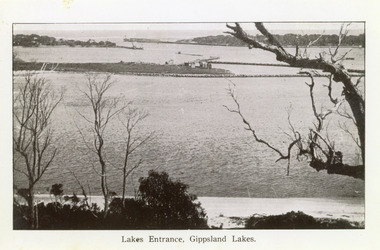
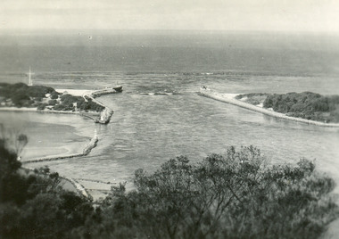
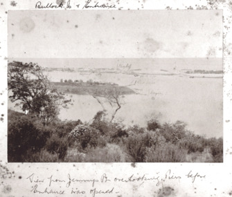 Lakes Entrance Historical Society
Photograph - Entrance viewed from Jemmys Point, Brooks Photographic Union, 1888 c
... Marked on photo Gilders Jetty Flag Staff Red light and groynes on Bullock Island...Lakes Entrance Historical Society 4 Marine Parade Lakes Entrance gippsland Marked on photo Gilders Jetty Flag Staff Red light and groynes on Bullock Island Waterways Islands Gippsland Lakes Bullock Island and Entrance View from Jemmys Point overlooking piers before Entrance was opened Black and white photograph of New Works area prior to opening Lakes Entrance Victoria Photograph Entrance viewed from Jemmys Point Brooks Photographic Union ...Marked on photo Gilders Jetty Flag Staff Red light and groynes on Bullock IslandBlack and white photograph of New Works area prior to opening Lakes Entrance VictoriaBullock Island and Entrance View from Jemmys Point overlooking piers before Entrance was openedwaterways, islands, gippsland lakes -
Glenelg Shire Council Cultural Collection
Photograph - Photograph - Aerial shot of rock wall Dutton Way, n.d
... Coloured aerial photograph of the rock wall & groynes at Dutton Way. Taken from slightly different perspective to 2853...Glenelg Shire Council Cultural Collection History House Cliff Street Portland great-ocean-road Port of Portland Authority Archives Port of Portland Archives Dutton Way Coloured aerial photograph of the rock wall & groynes at Dutton Way. Taken from slightly different perspective to 2853 Photograph Photograph - Aerial shot of rock wall Dutton Way ...Port of Portland Authority Archivesport of portland archives, dutton way -
 Lakes Entrance Historical Society
Photograph - Bullock Island and rock groynes, Carpenter Town settlement at New Works, and the Entrance at Lakes Entrance, Victoria, 1950c
... Black and white photograph of Bullock Island and rock groynes, Carpenter Town settlement at New Works, and the Entrance at Lakes Entrance, Victoria...Waterways Dredging Islands Black and white photograph of Bullock Island and rock groynes, Carpenter Town settlement at New Works, and the Entrance at Lakes Entrance, Victoria Photograph Bullock Island and rock groynes, Carpenter Town settlement at New Works, and the Entrance at Lakes Entrance, Victoria ...Black and white photograph of Bullock Island and rock groynes, Carpenter Town settlement at New Works, and the Entrance at Lakes Entrance, Victoriawaterways, dredging, islands -
 Lakes Entrance Historical Society
Photograph - Rigby Island, Gippsland Lakes c1990, Tambo Shire
... It shows the scrub covered hummocks in the background, Hopetoun Channel, dumped sand which connects Snake Island and Rigby Islands, groynes into Narrows from Rigby Island. Fishing boat with scallop dredge moored in sheltered bay inside a groyne. ...It shows the scrub covered hummocks in the background, Hopetoun Channel, dumped sand which connects Snake Island and Rigby Islands, groynes into Narrows from Rigby Island. Fishing boat with scallop dredge moored in sheltered bay inside a groyne. ...Second copyColour photograph of the south eastern shore of Rigby Island, Gippsland Lakes. It shows the scrub covered hummocks in the background, Hopetoun Channel, dumped sand which connects Snake Island and Rigby Islands, groynes into Narrows from Rigby Island. Fishing boat with scallop dredge moored in sheltered bay inside a groyne. Lakes Entrance Victoria waterways, topography, fishing industry, dredging -
 Lakes Entrance Historical Society
Photograph - The Entrance Lakes Entrance
... Black and white photographs of views of the entrance and rock groynes around Bullock Island taken from Kalimna Heights Lakes Entrance Victoria...Lakes Entrance Historical Society 4 Marine Parade Lakes Entrance gippsland Waterways Islands Black and white photographs of views of the entrance and rock groynes around Bullock Island taken from Kalimna Heights Lakes Entrance Victoria Photograph The Entrance Lakes Entrance ...Black and white photographs of views of the entrance and rock groynes around Bullock Island taken from Kalimna Heights Lakes Entrance Victoriawaterways, islands -
 Lakes Entrance Historical Society
Postcard - SS Despatch, c1910
... Small format postcard showing coastal steamer SS Despatch leaving Cunninghame Arm, with entrance piers and rock groynes in view. Lakes Entrance Victoria...Lakes Entrance Historical Society 4 Marine Parade Lakes Entrance gippsland Second copy same view Jetties Topography Ships and Shipping The Piers from the lookout at Jemmys Point (on back) Small format postcard showing coastal steamer SS Despatch leaving Cunninghame Arm, with entrance piers and rock groynes in view. Lakes Entrance Victoria Postcard SS Despatch ...Second copy same viewSmall format postcard showing coastal steamer SS Despatch leaving Cunninghame Arm, with entrance piers and rock groynes in view. Lakes Entrance VictoriaThe Piers from the lookout at Jemmys Point (on back)jetties, topography, ships and shipping -
 Lakes Entrance Historical Society
Postcard - The Entrance, 1910c
... It shows the entrance and groynes at Bullock Island, natural vegetation on cliff top in foreground. ...It shows the entrance and groynes at Bullock Island, natural vegetation on cliff top in foreground. ...Colour tinted postcard of the man made entrance to the Gippsland Lakes. It shows the entrance and groynes at Bullock Island, natural vegetation on cliff top in foreground. Lakes Entrance VictoriaLakes Entrance at Kalimna, Gippsland Lakes Victoriavegetation, waterways, topography -
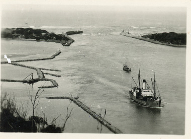
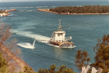
 Lakes Entrance Historical Society
Photograph - April Hamer, Fraser, Ian, 1980 c
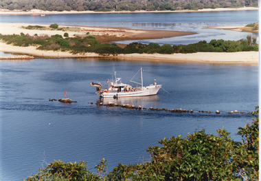
... Photo shows rock groynes at entrance. Lakes Entrance Victoria...Photo shows rock groynes at entrance. Lakes Entrance Victoria Photograph April Hamer Fraser, Ian ...Colour photograph of the side casting dredge, April Hamer, working at the entrance. Ocean in background, entrance to Gippsland Lakes. Photo shows rock groynes at entrance. Lakes Entrance Victoriajetties, waterways, ships and shipping -
 Lakes Entrance Historical Society
Postcard - The Entrance at Lakes Entrance, Murray Studios Gympy Qld, 1930 c
... Coloured postcard showing view of houses at the entrance and New Works buildings and western end of Bullock Island and rock groynes. Post and rail fence on Jemmys Point Lakes Entrance Victoria...Lakes Entrance Historical Society 4 Marine Parade Lakes Entrance gippsland Also a second hand colourewd postcard of similar view showing navigation light on right side of photo 05366.1 6.5 x 10 cm Waterways Islands Murray views No 32 A picture view of the Entrance at Lakes Entrance Coloured postcard showing view of houses at the entrance and New Works buildings and western end of Bullock Island and rock groynes. Post and rail fence on Jemmys Point Lakes Entrance Victoria Postcard The Entrance at Lakes Entrance Murray Studios Gympy Qld ...Also a second hand colourewd postcard of similar view showing navigation light on right side of photo 05366.1 6.5 x 10 cmColoured postcard showing view of houses at the entrance and New Works buildings and western end of Bullock Island and rock groynes. Post and rail fence on Jemmys Point Lakes Entrance VictoriaMurray views No 32 A picture view of the Entrance at Lakes Entrancewaterways, islands -
 Lakes Entrance Historical Society
Photograph - The Entrance c1922, Lakes Entrance, Gippsland Lakes, 1922c
... It shows the western end of Bullock Island with bathing boxes, rock groynes, and sandy shore beneath Jemmys Point. ...It shows the western end of Bullock Island with bathing boxes, rock groynes, and sandy shore beneath Jemmys Point. ...Black and white copy 9.5 x 15|Black and white copy 12x18Black and white photograph of the entrance and Bullock Island. It shows the western end of Bullock Island with bathing boxes, rock groynes, and sandy shore beneath Jemmys Point. Lakes Entrance VictoriaLakes Entrance, Gippsland Lakesislands, waterways, topography -
 Lakes Entrance Historical Society
Postcard - The Entrance, 1940c
... Black and white postcard of Bullock Island, and rock groynes, Reeves and Entrance Channels and Carpenter Town at the New Works, taken from Jemmys Point, dense vegetation in foreground. ...Lakes Entrance Historical Society 4 Marine Parade Lakes Entrance gippsland Also one similar images, 7 x 12.5, donated by Pam Cole, Lara Vic Waterways Topography Township The Entrance Lakes Entrance Black and white postcard of Bullock Island, and rock groynes, Reeves and Entrance Channels and Carpenter Town at the New Works, taken from Jemmys Point, dense vegetation in foreground. ...Also one similar images, 7 x 12.5, donated by Pam Cole, Lara VicBlack and white postcard of Bullock Island, and rock groynes, Reeves and Entrance Channels and Carpenter Town at the New Works, taken from Jemmys Point, dense vegetation in foreground. Lakes Entrance VictoriaThe Entrance Lakes Entrance waterways, topography, township -
 Lakes Entrance Historical Society
Photograph - SS Tambar, c1930
... Another smaller vessel behind, rock groynes visible for formation of Bullock Island. ...Another smaller vessel behind, rock groynes visible for formation of Bullock Island. ...Also black and white copy 8 x 13Small format black and white photograph of SS Tambar heading inbound towards Nungurner. Another smaller vessel behind, rock groynes visible for formation of Bullock Island. Lakes Entrance Victoriaships and shipping, jetties, waterways -
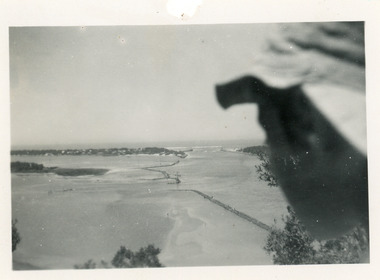
 Lakes Entrance Historical Society
Photograph - The Entrance, 1939c
... Black and white photograph of Bullock Island, rock groynes, lake and man-made entrance taken from Jemmys Point. ...Lakes Entrance Historical Society 4 Marine Parade Lakes Entrance gippsland Waterways Topography Black and white photograph of Bullock Island, rock groynes, lake and man-made entrance taken from Jemmys Point. ...Black and white photograph of Bullock Island, rock groynes, lake and man-made entrance taken from Jemmys Point. Three people sitting on grass in left foreground. Lakes Entrance Victoriawaterways, topography -
 Lakes Entrance Historical Society
Photograph - April Hamer, Fraser, Ian, 1980 c
... Ocean in background, rock groynes of the entrance visible, a fishing boat coming through the entrance. ...Ocean in background, rock groynes of the entrance visible, a fishing boat coming through the entrance. ...Colour photograph of the sand dredge, April Hamer, working inside the entrance off Bullock Island. Ocean in background, rock groynes of the entrance visible, a fishing boat coming through the entrance. Lakes Entrance Victoriawaterways, dredging -
 Lakes Entrance Historical Society
Postcard - The Entrance, 1940c
... It also shows the rock groynes at Bullock Island and entrance to Cunninghame Arm. ...It also shows the rock groynes at Bullock Island and entrance to Cunninghame Arm. ...Black and white small format postcard of the man-made entrance to the Gippsland Lakes taken from Jemmys Point. It also shows the rock groynes at Bullock Island and entrance to Cunninghame Arm. Lakes Entrance Victoriawaterways, topography -
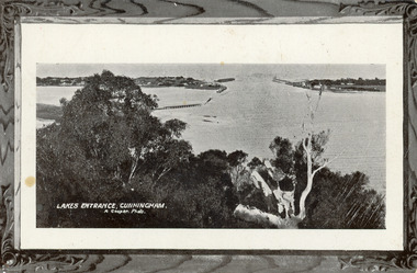 Lakes Entrance Historical Society
Postcard - The Entrance, 1905c
... It shows the works building and cottages on each side of the entrance, timber cribs and rock groynes at Bullock Island, natural vegetation of Jemmys Point in foreground. ...It shows the works building and cottages on each side of the entrance, timber cribs and rock groynes at Bullock Island, natural vegetation of Jemmys Point in foreground. ...Message on back of card, to 'Misses M & A Henderson, Swan Reach, Just a line to wish ......, Yours sincerely, R J Gilsenan.'Black and white postcard of the man made entrance. It shows the works building and cottages on each side of the entrance, timber cribs and rock groynes at Bullock Island, natural vegetation of Jemmys Point in foreground. Lakes Entrance VictoriaLakes Entrance, Cunningham topography, waterways, correspondence