Showing 7 items matching "hampton avenue"
-
 Sunshine and District Historical Society Incorporated
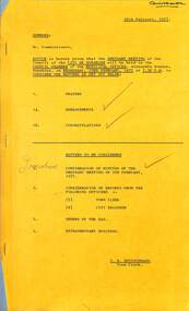
Administrative record - City of Sunshine - Commissioner Mr Alexander Alex George Gillon Collection 1976 - 1982 - Notice of ordinary meeting of the council of the City of Sunshine to be held on 23rd February 1977, City of Sunshine, 16th February 1977
... ...Hampton Avenue...Hampton Avenue private street scheme Public open space Graham Street South Crown Lands Kororoit Creek Anderson Road Sunshine Land Use Permit Consulting Rooms Ainsworth Avenue Council Officers Reports...City of Sunshine Alexander "Alex" George Gillon Anderson Road Sunshine Graham Street South Hampton Avenue Hampton Avenue private street scheme Public open space Graham Street South Crown Lands Kororoit Creek Anderson Road Sunshine Land Use Permit Consulting Rooms Ainsworth Avenue Council Officers Reports Foolscap sized document. ...Hampton Avenue private street scheme Public open space Graham Street South Crown Lands Kororoit Creek Anderson Road Sunshine Land Use Permit Consulting Rooms Ainsworth Avenue Council Officers Reports city of sunshine, alexander "alex" george gillon, anderson road, sunshine, graham street south, hampton avenue -
 Sunshine and District Historical Society Incorporated
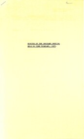
Administrative record - City of Sunshine - Commissioner Mr Alexander Alex George Gillon Collection 1976 - 1982 - Minutes of the ordinary meeting of council held on 23rd February 1977, City of Sunshine, 23rd February 1977
... ...Hampton Avenue...Hampton Avenue private street scheme Public open space Graham Street South Crown Lands Kororoit Creek Anderson Road Sunshine Land Use Permit Consulting Rooms Ainsworth Avenue Land Use Permit Extension to school Ballarat Road Deer Park Land Use Permit Alterations to Greek Orthodox Church of St Andrew Corner Simmie Street and St. ...City of Sunshine Alexander "Alex" George Gillon Hampton Avenue Sunshne Sydney Street Albion Kororoit Creek Anderson Road Graham Street South Ainsworth Avenue Sunshine West Greek Orthodox Church of St Andrew Simmie Street St. ...Hampton Avenue private street scheme Public open space Graham Street South Crown Lands Kororoit Creek Anderson Road Sunshine Land Use Permit Consulting Rooms Ainsworth Avenue Land Use Permit Extension to school Ballarat Road Deer Park Land Use Permit Alterations to Greek Orthodox Church of St Andrew Corner Simmie Street and St. Andrews Street Land Use Permit Amusement Parlour 32a Sydney Street Council Officers Reports city of sunshine, alexander "alex" george gillon, hampton avenue, sunshne, sydney street, albion, kororoit creek, anderson road, graham street south, ainsworth avenue, sunshine west, greek orthodox church of st andrew, simmie street, st. andrews street -
 Surrey Hills Historical Society Collection
Photograph, Preparing to leave for the St George's Church of England Sunday School picnic, Mont Albert Road, 1922, 1922
... Its current address is 19 St Georges Avenue, Mont Albert. The annual Sunday School picnic was held at Hampton and drags were the usual mode of transport. ...Its current address is 19 St Georges Avenue, Mont Albert. The annual Sunday School picnic was held at Hampton and drags were the usual mode of transport. ...The drags would have been leaving St George's Church of England in Mont Albert Road. The foundation stone for St George's Church of England, Mont Albert was laid in 1886 on land donated by Edward Dyer and the first service was preached in January 1887. From 1904 until 1907 it was known as Holy Trinity, Surrey Hills. The original church was weatherboard and replaced by a brick one in the Gothic Revival style which was designed by local architect George J V Blackburne, who also designed the Wesleyan School at Surrey Hills. The building was partly funded by donations, profits from a bazaar and concert, and other people donated furnishings. The church had boundaries along Mont Albert Road and St Georges Road. In 1998 the Church was sold and converted into a complex of units. Its current address is 19 St Georges Avenue, Mont Albert. The annual Sunday School picnic was held at Hampton and drags were the usual mode of transport. 'Lugano' was built in 1893 for William Wilson, a prominent stonemason and importer of marble fireplaces. In 1903 it became the home of William Holmes who was Chief Electrical Engineer for the Victorian Railways. He designed the electrification of the Melbourne suburban network. 'Lugano' stayed in the Holmes family until the 1930s. The annual Sunday School picnic was held at at a variety of locations and drags were the usual mode of transport. Donor information is that this was taken as the congregation prepared to depart for at Hampton on the picnic held on 25/2/1922. There are 2 copies: the original donated print and an enlargement. The original was mounted on card with photo mounts along with 506, 871, 872, and 873. It measures 13 cm x 9 cm.Black and white photo of 4 'drags' (horse-drawn hooded carriages) lined up in Mont Albert Road near the corner of St George's Avenue, in readiness for departure for the Sunday School picnic. The carriages are loaded with people and decorated with flags. The front carriage has a material sign attached to the side; the top line of writing is not decipherable, but the bottom one reads "SURREY HILLS". Four men stand in the road, which has bluestone curb and channelling. In the background is 'Lugano'.On rear in ink: "S.S. picnic to Hampton / 25th. Feb. 1922" and in a different hand in biro: "At Mont Albert. St George's Church"churches, holy trinity church, anglican church, sunday schools, picnics, lugano, horse-drawn vehicles, william wilson, willaim holmes, st george's church of england, mont albert, mont albert road -
 City of Kingston
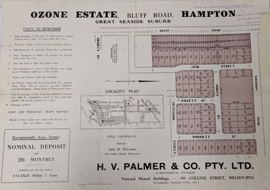
Pamphlet - Colour, Farrow Falcon Press, Printers, Ozone Estate, Bluff Road, Hampton, c.1940
... Sales plan for land in the suburb of Hampton (Highett), bounded by Bluff Road, Wickham Road, Peterson Street and June Street. Includes Morley Street, Follett Avenue, and Parrett Street...Hampton. Incorporates a map of the estate bordered by Bluff Road, Wickham Road, June Street and Peterson Street including Morley Street, Follett Avenue and Parrett Street....Hampton. Incorporates a map of the estate bordered by Bluff Road, Wickham Road, June Street and Peterson Street including Morley Street, Follett Avenue and Parrett Street. ...Sales plan for land in the suburb of Hampton (Highett), bounded by Bluff Road, Wickham Road, Peterson Street and June Street. Includes Morley Street, Follett Avenue, and Parrett StreetThe developing urban area of Highett within the City of Kingston. This land sale pamphlet illustrates the subdivision of land within the municipality and the changing demographic of the district as new houses are constructed close to infrastructure.Colour pamphlet advertising for private sale the Ozone Estate, Bluff Road Hampton. Incorporates a map of the estate bordered by Bluff Road, Wickham Road, June Street and Peterson Street including Morley Street, Follett Avenue and Parrett Street.Handwritten in grey pencil on reverse: Ozone Printed in purple ink on front top right-hand corner: Vendors are - Leslie Harcourt MacGowan, Esq / Neerim Road, Caulfield / & / Arthur Alfred Parrett, Esq / 311 Flinders Lane / Melbourneland sales, estate, hampton, highett -
 City of Kingston
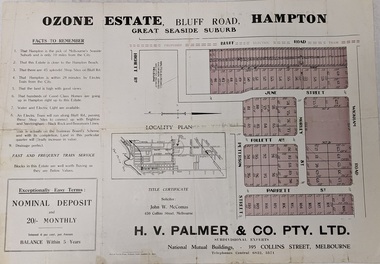
Pamphlet - Colour, Farrow Falcon Press, Printers, Ozone Estate, Bluff Road, Hampton, c. 1940
... Sales plan for land in the suburb of Hampton (Highett), bounded by Bluff Road, Wickham Road, Peterson Street and June Street. Includes Morley Street, Follett Avenue, and Parrett Street...Hampton. Incorporates a map of the estate bordered by Bluff Road, Wickham Road, June Street and Peterson Street including Morley Street, Follett Avenue and Parrett Street....Hampton. Incorporates a map of the estate bordered by Bluff Road, Wickham Road, June Street and Peterson Street including Morley Street, Follett Avenue and Parrett Street. ...Sales plan for land in the suburb of Hampton (Highett), bounded by Bluff Road, Wickham Road, Peterson Street and June Street. Includes Morley Street, Follett Avenue, and Parrett StreetThe developing urban area of Highett within the City of Kingston. This land sale pamphlet illustrates the subdivision of land within the municipality and the changing demographic of the district as new houses are constructed close to infrastructure.Colour pamphlet advertising for private sale the Ozone Estate, Bluff Road Hampton. Incorporates a map of the estate bordered by Bluff Road, Wickham Road, June Street and Peterson Street including Morley Street, Follett Avenue and Parrett Street.Handwritten in grey pencil on rear: Ozone Estateland sales, estate, highett, hampton -
 Narre Warren and District Family History Group
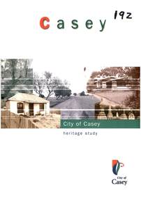
Book, Graeme Butler et al, City of Casey Heritage Study : Cranbourne, Knox
... Avenue of Honour...Stella Maris: Tooradin...Holy Trinity Church of England: Hampton...Westernport Bay Clyde Railway Bridge Royal Botanic Gardens Cranbourne Ridgway Farm Cranbourne Hook's Farm Clyde North St Paul's Church of England Clyde North Wingilla: Cannons Creek Churchill National Park Murphy's House: Hampton Park Cloverdale Cottage Hill Farm: Five Ways Menia Park: Devon Meadows Lynwood Park: Cranbourne Valentine Park: Lyndhurst Eclipse Park: Lyndhurst Eskdale: Lyndhurst Picnic Park: Lyndhurst Kernot's house: Tooradin Eyre Court: Cranbourne North Hayton Park: Cranbourne Ercildoune: Cranbourne Warren Park: Lysterfield Motor Club Hotel St Agatha's Catholic Church Perry Park: Cranbourne McMorran's Oak: Cranbourne Lysterfield Lake Tooradin Railway Station ground St Peters Church of England: Pearcedale Springmount: Cranbourne North Moran Reserve Botanic Rise Estate Clyde Uniting Church Clyde Railway Station site Clyde Township precinct Cranbourne Cemetery Maratala: Cranbourne Cranbourne Avenue of Honour Tooradin Avenue of Honour Stella Maris: Tooradin Holy Trinity Church of England: Hampton Park Spring Meadows: Cranbourne North Blue Lagoons: Cranbourne North Oakwood: Clyde North Tooradin Memorial Hall St Peters Catholic Church: Tooradin Tooradin State School Mayfield: Clyde North Fernlea: Clyde Citations from stage one of the City of Casey Heritage Study of places in the City of Casey from the former Cranbourne Shire and present Knox City areas. ...Citations from stage one of the City of Casey Heritage Study of places in the City of Casey from the former Cranbourne Shire and present Knox City areas. ***This is much the same content as ARC 019-6 but the photos and layout are slightly different. Many of the photos in this book are not as clear as the photos in ARC 019-6. This publication can be downloaded from the City of Casey website.non-fictionCitations from stage one of the City of Casey Heritage Study of places in the City of Casey from the former Cranbourne Shire and present Knox City areas. ***This is much the same content as ARC 019-6 but the photos and layout are slightly different. Many of the photos in this book are not as clear as the photos in ARC 019-6. This publication can be downloaded from the City of Casey website. westernport bay, clyde railway bridge, royal botanic gardens cranbourne, ridgway farm cranbourne, hook's farm clyde north, st paul's church of england clyde north, wingilla: cannons creek, churchill national park, murphy's house: hampton park, cloverdale cottage, hill farm: five ways, menia park: devon meadows, lynwood park: cranbourne, valentine park: lyndhurst, eclipse park: lyndhurst, eskdale: lyndhurst, picnic park: lyndhurst, kernot's house: tooradin, eyre court: cranbourne north, hayton park: cranbourne, ercildoune: cranbourne, warren park: lysterfield, motor club hotel, st agatha's catholic church, perry park: cranbourne, mcmorran's oak: cranbourne, lysterfield lake, tooradin railway station ground, st peters church of england: pearcedale, springmount: cranbourne north, moran reserve, botanic rise estate, clyde uniting church, clyde railway station site, clyde township precinct, cranbourne cemetery, maratala: cranbourne, cranbourne avenue of honour, tooradin avenue of honour, stella maris: tooradin, holy trinity church of england: hampton park, spring meadows: cranbourne north, blue lagoons: cranbourne north, oakwood: clyde north, tooradin memorial hall, st peters catholic church: tooradin, tooradin state school, mayfield: clyde north, fernlea: clyde -
 Narre Warren and District Family History Group
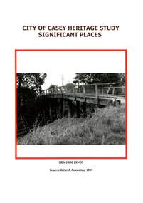
Book, Graeme Butler & Associates, City of Casey Heritage Study : Significant Places, 1997
... Avenue of Honour...Stella Maris: Tooradin...Holy Trinity Church of England: Hampton...Westernport Bay Clyde Railway Bridge Royal Botanic Gardens Cranbourne Ridgway Farm Cranbourne Hook's Farm Clyde North St Paul's Church of England Clyde North Wingilla: Cannons Creek Churchill National Park Murphy's House: Hampton Park Cloverdale Cottage Hill Farm: Five Ways Menia Park: Devon Meadows Lynwood Park: Cranbourne Valentine Park: Lyndhurst Eclipse Park: Lyndhurst Eskdale: Lyndhurst Picnic Park: Lyndhurst Kernot's house: Tooradin Eyre Court: Cranbourne North Hayton Park: Cranbourne Ercildoune: Cranbourne Warren Park: Lysterfield Motor Club Hotel St Agatha's Catholic Church Perry Park: Cranbourne McMorran's Oak: Cranbourne Lysterfield Lake Tooradin Railway Station ground St Peters Church of England: Pearcedale Springmount: Cranbourne North Moran Reserve Botanic Rise Estate Clyde Uniting Church Clyde Railway Station site Clyde Township precinct Cranbourne Cemetery Maratala: Cranbourne Cranbourne Avenue of Honour Tooradin Avenue of Honour Stella Maris: Tooradin Holy Trinity Church of England: Hampton Park Spring Meadows: Cranbourne North Blue Lagoons: Cranbourne North Oakwood: Clyde North Tooradin Memorial Hall St Peters Catholic Church: Tooradin Tooradin State School Mayfield: Clyde North Fernlea: Clyde Citations from stage one of the City of Casey Heritage Study of places in the City of Casey from the former Cranbourne Shire and present Knox City areas. ...Citations from stage one of the City of Casey Heritage Study of places in the City of Casey from the former Cranbourne Shire and present Knox City areas. ***This is much the same content as ARC 019-4 but the photos and layout are slightly different. Many of the photos in this book are clearer and lighter than the ones in ARC 019-4. This publication can be downloaded from the City of Casey website.non-fictionCitations from stage one of the City of Casey Heritage Study of places in the City of Casey from the former Cranbourne Shire and present Knox City areas. ***This is much the same content as ARC 019-4 but the photos and layout are slightly different. Many of the photos in this book are clearer and lighter than the ones in ARC 019-4. This publication can be downloaded from the City of Casey website. westernport bay, clyde railway bridge, royal botanic gardens cranbourne, ridgway farm cranbourne, hook's farm clyde north, st paul's church of england clyde north, wingilla: cannons creek, churchill national park, murphy's house: hampton park, cloverdale cottage, hill farm: five ways, menia park: devon meadows, lynwood park: cranbourne, valentine park: lyndhurst, eclipse park: lyndhurst, eskdale: lyndhurst, picnic park: lyndhurst, kernot's house: tooradin, eyre court: cranbourne north, hayton park: cranbourne, ercildoune: cranbourne, warren park: lysterfield, motor club hotel, st agatha's catholic church, perry park: cranbourne, mcmorran's oak: cranbourne, lysterfield lake, tooradin railway station ground, st peters church of england: pearcedale, springmount: cranbourne north, moran reserve, botanic rise estate, clyde uniting church, clyde railway station site, clyde township precinct, cranbourne cemetery, maratala: cranbourne, cranbourne avenue of honour, tooradin avenue of honour, stella maris: tooradin, holy trinity church of england: hampton park, spring meadows: cranbourne north, blue lagoons: cranbourne north, oakwood: clyde north, tooradin memorial hall, st peters catholic church: tooradin, tooradin state school, mayfield: clyde north, fernlea: clyde