Showing 22 items matching "heatherdale road vermont"
-
 Ringwood and District Historical Society
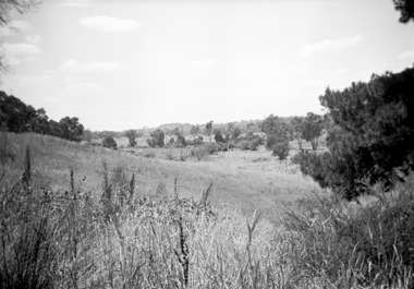
Photograph, Looking east along Dandenong Creek from very end of Heatherdale Road, Vermont South, January 1979
... Looking east along Dandenong Creek from very end of Heatherdale Road, Vermont South, January 1979...Heatherdale Road." Looking east along Dandenong Creek from very end of Heatherdale Road, Vermont South, January 1979 Photograph ...Written on back of photograph, "Jan. 79. Looking east along Dandenong Creek from very end of Heatherdale Road." -
 Whitehorse Historical Society Inc.
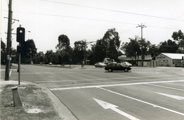
Photograph, Heatherdale/Canterbury Roads, 2000
... ...heatherdale road vermont...Black and white photograph - print and negative of Intersection of Heatherdale Road and Canterbury Road, Vermont, looking towards North West corner at Vermont. ...Whitehorse Historical Society Inc. 2-10 Deep Creek Road Mitcham melbourne Produced as one of a series of 24 prints commissioned by Nunawading & District Historical Society -|Theme: Intersections of Mitcham and Nunawading 2000/2001.|See also Series by P. Simmenauer on the same theme. vermont value vet veterinarian - vermont heatherdale ...Produced as one of a series of 24 prints commissioned by Nunawading & District Historical Society -|Theme: Intersections of Mitcham and Nunawading 2000/2001.|See also Series by P. Simmenauer on the same theme.Black and white photograph - print and negative of Intersection of Heatherdale Road and Canterbury Road, Vermont, looking towards North West corner at Vermont. Value Vet established 1960's - 1970's. Existing building built late 1990's.vermont value vet, veterinarian - vermont, heatherdale road vermont, canterbury road vermont -
 Whitehorse Historical Society Inc.
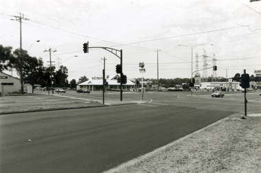
Photograph, Corner Heatherdale & Canterbury Roads, 2000
... heatherdale road vermont...Black and white photograph - print and negative of Intersection of Heatherdale Road and Canterbury Road border with Vermont, looking towards North East corner. ...Simmenauer on the same theme. heatherdale road vermont canterbury road vermont Black and white photograph - print and negative of Intersection of Heatherdale Road and Canterbury Road border with Vermont, looking towards North East corner. ...Produced as one of a series of 24 prints commissioned by Nunawading & District Historical Society -|Theme: Intersections of Mitcham and Nunawading 2000/2001.|See also Series by P. Simmenauer on the same theme.Black and white photograph - print and negative of Intersection of Heatherdale Road and Canterbury Road border with Vermont, looking towards North East corner. In view is Red Rooster Fast Food outlet on corner.heatherdale road vermont, canterbury road vermont -
 Whitehorse Historical Society Inc.
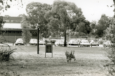
Photograph, Heatherdale Reserve, 2000
... ...heatherdale road vermont...Whitehorse Historical Society Inc. 2-10 Deep Creek Road Mitcham melbourne Produced as one of a series of 24 prints commissioned by Nunawading & District Historical Society -|Theme: Intersections of Mitcham and Nunawading 2000/2001.|See also Series by P. Simmenauer on the same theme. heatherdale bowls club heatherdale road vermont ...Produced as one of a series of 24 prints commissioned by Nunawading & District Historical Society -|Theme: Intersections of Mitcham and Nunawading 2000/2001.|See also Series by P. Simmenauer on the same theme.Black and white photograph - print and negative of Heatherdale Reserve - Whitehorse side of Heatherdale Road - Features view of Heatherdale Bowls Club with flower garden. Located between Purches Street and Heatherdale Road to south of Panel street.heatherdale bowls club, heatherdale road vermont, heatherdale reserve -
 Whitehorse Historical Society Inc.
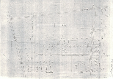
Document, Map of Vermont & Mitcham
... heatherdale road...canterbury road...vermont...Copy of map showing land in Mitcham and Vermont areas bounded by Whitehorse , Mitcham, Canterbury and Heatherdale roads....Whitehorse Historical Society Inc. 2-10 Deep Creek Road Mitcham melbourne land subdivision whitehorse road mitcham heatherdale road canterbury road vermont mitcham road Copy of map showing land in Mitcham and Vermont areas Copy of map showing land in Mitcham and Vermont areas bounded by Whitehorse , Mitcham, Canterbury and Heatherdale roads. ...Copy of map showing land in Mitcham and Vermont areasCopy of map showing land in Mitcham and Vermont areas bounded by Whitehorse , Mitcham, Canterbury and Heatherdale roads.Copy of map showing land in Mitcham and Vermont areasland subdivision, whitehorse road, mitcham, heatherdale road, canterbury road, vermont, mitcham road -
 Whitehorse Historical Society Inc.
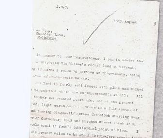
Letter - Correspondence, Heatherdale Estate
... heatherdale estate...watson (mrs)...purches street...vermont...canterbury road...Letter from valuer re land owned by Mrs Watson - corner of Purches Street and Canterbury Roads, Vermont (Heatherdale Estate)...Whitehorse Historical Society Inc. 2-10 Deep Creek Road Mitcham melbourne land values heatherdale estate watson (mrs) purches street vermont canterbury road Letter from valuer re land owned by Mrs Watson Letter from valuer re land owned by Mrs Watson - corner of Purches Street and Canterbury Roads, Vermont (Heatherdale Estate) Heatherdale Estate Letter Correspondence ...Letter from valuer re land owned by Mrs WatsonLetter from valuer re land owned by Mrs Watson - corner of Purches Street and Canterbury Roads, Vermont (Heatherdale Estate)Letter from valuer re land owned by Mrs Watsonland values, heatherdale estate, watson (mrs), purches street, vermont, canterbury road -
 Ringwood and District Historical Society
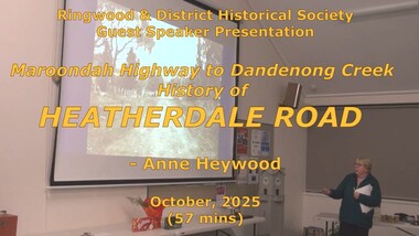
Mixed media - Video, RDHS Meeting Presentation - "Maroondah Highway to Dandenong Creek via Heatherdale Road" - Anne Heywood
... Vermont. The area has been a mixture of agriculture, then light industry, and is disected by rail and power lines, yet joins two major east-west arterial roads - Canterbury Road and Maroondah Highway. Digitised video (2.94GB). Duration: 57 minutes. Recorded October, 2025 (Video is available for viewing at Ringwood & District Historical Society Archives by appointment) RDHS Meeting Presentation - "Maroondah Highway to Dandenong Creek via Heatherdale Road" - Anne Heywood Mixed media Video ...Digitised video (2.94GB). Duration: 57 minutes. Recorded October, 2025 (Video is available for viewing at Ringwood & District Historical Society Archives by appointment)For this presentation, prominent researcher and RDHS member Anne Heywood has been busy uncovering the history of this relatively unknown area of Ringwood. It is the convergence of four suburbs - Mitcham, Ringwood, Heathmont and Vermont. The area has been a mixture of agriculture, then light industry, and is disected by rail and power lines, yet joins two major east-west arterial roads - Canterbury Road and Maroondah Highway. -
 Ringwood and District Historical Society
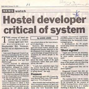
Newspaper, Scrapbook Clipping, Library Collection, Ringwood, Victoria
... Ringwood and District Historical Society 125A Warrandyte Road Ringwood North melbourne The owner of land approved for a controversial aged care development at Heatherdale Rd, Vermont, has hit out at objectors to the project. ...Newspaper Clipping from "The Mail", 23-2-1993. Hostel developer critical of system. Article by Janine JonesThe owner of land approved for a controversial aged care development at Heatherdale Rd, Vermont, has hit out at objectors to the project. Ringwood Council approved revised plans for the hostel at 177 Heatherdale Rd, Vermont, after a year of negotiations with the applicants, Lois and Bob McDonough. Council received 14 objections from neighbouring residents to the development. -
 Ringwood and District Historical Society
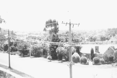
Photograph, Boundary photo. Heatherdale Rd. looking north east from Shibor Drive, Vermont. Jan. 1979
... Ringwood and District Historical Society 125A Warrandyte Road Ringwood North melbourne Written on back of photograph, "Jan. 79 - Boundary photo. Heatherdale Rd. looking north east. Taken at end of Shibor Dve (Vermont ...Written on back of photograph, "Jan. 79 - Boundary photo. Heatherdale Rd. looking north east. Taken at end of Shibor Dve (Vermont) (on high part end corner of school ground). One of 3 that join up." -
 Whitehorse Historical Society Inc.
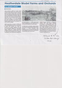
Article, Haines, Russ, Heatherdale Model Farms and Orchards
... Vermont. He listed it for sale in 1877 and the property had water storages, 2,000 fruit trees, paddocks sown with various English grasses, 6 acres of vineyards and a 6 room cottage. Smith Louis Lawrence Maggs Joseph Pyko's Orchard Haines Russ Dr. Louis Lawrence Smith owned several model farms in Victoria including 280 acres below Dandenong Creek and west of Heatherdale Road ...Dr. Louis Lawrence Smith owned several model farms in Victoria including 280 acres below Dandenong Creek and west of Heatherdale Road from 1856non-fictionDr. Louis Lawrence Smith owned several model farms in Victoria including 280 acres below Dandenong Creek and west of Heatherdale Road from 1856smith louis lawrence, maggs joseph, pyko's orchard, haines russ -
 Whitehorse Historical Society Inc.
Map, This is Vermont, 1895-1920?
... Hand-drawn map of Vermont from Springvale Road to Heatherdale Road, showing the names of owners of houses, main roads and streets, shops and schools....'Now you have seen it, tell your friends' - hand-drawn map of Vermont from Springvale Road to Heatherdale Road, showing the names of owners of houses, main roads and streets, shops and schools....Whitehorse Historical Society Inc. 2-10 Deep Creek Road Mitcham melbourne Hand-drawn map of Vermont from Springvale Road to Heatherdale Road, showing the names of owners of houses, main roads and streets, shops and schools. ...'Now you have seen it, tell your friends''Now you have seen it, tell your friends' - hand-drawn map of Vermont from Springvale Road to Heatherdale Road, showing the names of owners of houses, main roads and streets, shops and schools.'Now you have seen it, tell your friends' vermont south, vermont, roads and streets -
Whitehorse Historical Society Inc.
Map, before 1890
... Whitehorse Historical Society Inc. 2-10 Deep Creek Road Mitcham melbourne Mitcham Vermont Nunawading Early map showing location and areas of plots and their owners' names between Heatherdale Road in the east and Springvale Road in the west, Burwood Road to the south to north of Canterbury Road. ...Early map showing location and areas of plots and their owners' names between Heatherdale Road in the east and Springvale Road in the west, Burwood Road to the south to north of Canterbury Road. Later additions to 1969Early map showing location and areas of plots and their owners' names between Heatherdale Road in the east and Springvale Road in the west, Burwood Road to the south to north of Canterbury Road. Later additions to 1969Early map showing location and areas of plots and their owners' names between Heatherdale Road in the east and Springvale Road in the west, Burwood Road to the south to north of Canterbury Road. Later additions to 1969mitcham, vermont, nunawading -
Whitehorse Historical Society Inc.
Document, Viewings, 1998
... road...vermont...arlington heights estate...heatherdale...Whitehorse Historical Society Inc. 2-10 Deep Creek Road Mitcham melbourne fulton road blackburn south illowra walk illowra views australand land subdivision centre road vermont arlington heights estate heatherdale road rowan street arlington walk 'Viewings', Melbourne Edition One 1998, by Australand, detailing housing developments in Blackburn South, 'Illowra Views', and other areas. ...'Viewings', Melbourne Edition One 1998, by Australand, detailing housing developments in Blackburn South, 'Illowra Views', and other areas.fulton road, blackburn south, illowra walk, illowra views, australand, land subdivision, centre road, vermont, arlington heights estate, heatherdale road, rowan street, arlington walk -
 Whitehorse Historical Society Inc.
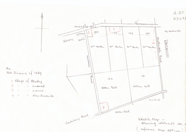
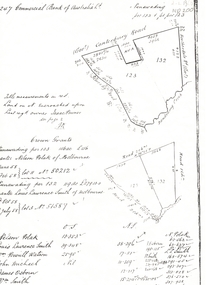
Document, Subdivisions 1859, nd
... heatherdale road...mitcham...purches street...mitcham road...vermont...Whitehorse Historical Society Inc. 2-10 Deep Creek Road Mitcham melbourne land subdivision heatherdale road mitcham purches street mitcham road vermont canterbury road whitehorse road brunswick road creek road centre road studley village new brunswick village Sketch map of subdivisions of 1859. ...Sketch map of subdivisions of 1859.Sketch map of subdivisions of 1859. Allotment 126 and portions of 125, 126 and 130, including 'Village of Studley', 'Village of New Brunswick' and two unnamed. Information from Mr McComb, retired surveyor; sketch and notes. Areas near railway line east of Mitcham Station and North East corner of Canterbury and Mitcham Roads. Refer map A - SP 110.Sketch map of subdivisions of 1859.land subdivision, heatherdale road, mitcham, purches street, mitcham road, vermont, canterbury road, whitehorse road, brunswick road, creek road, centre road, studley village, new brunswick village -
Whitehorse Historical Society Inc.
Article, Thousands switch seats; Deakin spills east, 1968
... Whitehorse Historical Society Inc. 2-10 Deep Creek Road Mitcham melbourne The changes also affect Blackburn, East Burwood, Forest Hill, Vermont and Heatherdale. ...Photocopy of article about an electoral redistribution which transfers part of Box Hill from Bruce to Deakin.Photocopy of article about an electoral redistribution which transfers part of Box Hill from Bruce to Deakin. The changes also affect Blackburn, East Burwood, Forest Hill, Vermont and Heatherdale.Photocopy of article about an electoral redistribution which transfers part of Box Hill from Bruce to Deakin. electoral boundaries, box hill, blackburn, burwood east, forest hill, vermont, heatherdale, jarman, alan -
Whitehorse Historical Society Inc.
Document, Progress and Progress Associations in the 20th century, 1988
... Whitehorse Historical Society Inc. 2-10 Deep Creek Road Mitcham melbourne A Nunawading Bicentennial community project, the booklet is the first of a series of three compiled during research for a new history of Nunawading which was to be published in 1990. Clubs and Associations Progress Associations Blackburn North Progress Association Heatherdale and District Progress Association Mitcham and Vermont Progress Association Blackburn Progress Association Nunawading Progress Association Vermont South Community Association Booklet outlining the history of Progress Associations. ...Booklet outlining the history of Progress Associations.Booklet outlining the history of Progress Associations. A Nunawading Bicentennial community project, the booklet is the first of a series of three compiled during research for a new history of Nunawading which was to be published in 1990.Booklet outlining the history of Progress Associations. clubs and associations, progress associations, blackburn north progress association, heatherdale and district progress association, mitcham and vermont progress association, blackburn progress association, nunawading progress association, vermont south community association -
Whitehorse Historical Society Inc.
Map, Nunawading Planning Scheme, 7/06/1994 12:00:00 AM
... Whitehorse Historical Society Inc. 2-10 Deep Creek Road Mitcham melbourne blackburn blackburn north blackburn south forest hill heatherdale maps nunawading vermont vermont south town planning burwood east laburnum Local Section maps 1 - 4 with index. ...Local Section maps 1 - 4 with index. Geographical information system land Information Branch. Scale 1:10,000 Shows zoning under planning scheme.Local Section maps 1 - 4 with index. Geographical information system land Information Branch. Scale 1:10,000 Shows zoning under planning scheme.Local Section maps 1 - 4 with index. Geographical information system land Information Branch. Scale 1:10,000 Shows zoning under planning scheme.blackburn, blackburn north, blackburn south, forest hill, heatherdale, maps, nunawading, vermont, vermont south, town planning, burwood east, laburnum -
Whitehorse Historical Society Inc.
Map, Mitcham Riding, n.d
... Whitehorse Historical Society Inc. 2-10 Deep Creek Road Mitcham melbourne mitcham maps vermont Shire of Nunawading: Mitcham Riding [n.d.] between Mitcham and Heatherdale Roads) (Shows electric light mains, MMBW reserves and railway line. ...Shire of Nunawading: Mitcham Riding [n.d.] between Mitcham and Heatherdale Roads) (Shows electric light mains, MMBW reserves and railway line.mitcham, maps, vermont -
 Whitehorse Historical Society Inc.
Document - Research Notes, Harry Scoble and Hilda Petschell (nee Scoble) from Heatherdale, 29 January 2021
... Whitehorse Historical Society Inc. 2-10 Deep Creek Road Mitcham melbourne Random facts pertaining to the lives of the Scoble family in particular Harry Scoble and his sister Hilda Petschell. 1930s - 1950's around Heatherdale, Vermont and Blackburn Scoble Harry Pannam Charlie Matheson Mary Petschell Hilda Scoble Hilda Fagg Keith Scoble's Poultry Farm SCOBLE Wilma About the lives of the Scoble family in particular Harry Scoble and his sister Hilda Petschell of Heatherdale and Vermont. ...About the lives of the Scoble family in particular Harry Scoble and his sister Hilda Petschell of Heatherdale and Vermont.A4, 8 pagesnon-fictionAbout the lives of the Scoble family in particular Harry Scoble and his sister Hilda Petschell of Heatherdale and Vermont.scoble harry, pannam charlie, matheson mary, petschell hilda, scoble hilda, fagg keith, scoble's poultry farm, scoble wilma -
 Whitehorse Historical Society Inc.
Document - Speech, MOORHOUSE Denise, Denise Moorhouse, 10/02/1996
... Whitehorse Historical Society Inc. 2-10 Deep Creek Road Mitcham melbourne Denise Moorhouse reflects on early education and living conditions in the 1800's Education Vermont State School No.1022 Heatherdale Primary School BOYLE David A transcript of the talk on early education and living conditions by Denise Moorhouse to the Nunawading Historical Society on 10/02/1996. ...A transcript of the talk on early education and living conditions by Denise Moorhouse to the Nunawading Historical Society on 10/02/1996.A transcript of the talk on early education and living conditions by Denise Moorhouse to the Nunawading Historical Society on 10/02/1996.non-fictionA transcript of the talk on early education and living conditions by Denise Moorhouse to the Nunawading Historical Society on 10/02/1996.education, vermont state school no.1022, heatherdale primary school, boyle david -
 Whitehorse Historical Society Inc.
Photograph, L L Road Vermont, late 1800
... Vermont District. He owned 250 acres in the area bounded by Boronia, Canterbury and Heatherdale Roads and the creek. ...Whitehorse Historical Society Inc. 2-10 Deep Creek Road Mitcham melbourne Dr L L Smith was a pioneer of the Vermont District. He owned 250 acres in the area bounded by Boronia, Canterbury and Heatherdale Roads and the creek. ...Dr L L Smith was a pioneer of the Vermont District. He owned 250 acres in the area bounded by Boronia, Canterbury and Heatherdale Roads and the creek. The property was known as L L Vale after which the road was named. Name was changed to Boronia Road in later years. He was a Doctor with rooms in the City, was a member of Parliament.Sepia Postcard of L L Road, Vermont (now Boronia Road) taken in the early 1900s (card is postmarked 27 Aug 1909). Shows the road going down it is presumed to the creek. It is possible that the house is that of Dr.L.L.Smith. See History.|Orchard in background is the Finger orchard. (from Mr. Shambrook - Tim's father)|Information on the back of the Postcard reveal it was sent to Miss Roberts of 61 Hoddle Street Richmond Victoria by Muriel at 37 Victoria Road Northcote and was posted at the Fairfield Post Office Victoria on 27 August 1909. Text is 'Dear Ethel Just a Post Card to let you know I will be out to see you on Monday if convenient. I came down with Mr Hutchinson and he asked me what were we laughing out on the Sunday when he came up. Muriel|See the following references -ND199, 313, 539. 1242, 2013, 3680 & 4295.l l road vermont, boronia road vermont, smith . l l dr -
 Whitehorse Historical Society Inc.
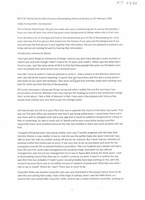
Legal record - Land Title, Crown grant, 1858
... road...vermont...boronia road...dandenong creek...heatherdale...polak nelson smith l l dr canterbury road vermont boronia road dandenong creek heatherdale road land sales Commercial Bank of Australia record of Crown Grants of land to Nelson Polak and Louis Laurence Smith in 1858. ...Commercial Bank of Australia record of Crown Grants of land to Nelson Polak and Louis Laurence Smith in 1858.Commercial Bank of Australia record of Crown Grants of land to Nelson Polak and Louis Laurence Smith in 1858. The land is between Canterbury Road, Heatherdale Road, 'Scoresby Road' (now Boronia Road) and the Dandenong Creek.Commercial Bank of Australia record of Crown Grants of land to Nelson Polak and Louis Laurence Smith in 1858. polak, nelson, smith, l l dr, canterbury road, vermont, boronia road, dandenong creek, heatherdale road, land sales