Showing 140 items matching "helicopter operations"
-
 National Vietnam Veterans Museum (NVVM)
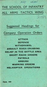
Booklet, The School of Infantry, The School of Infantry All Arms Tactis Wing: Suggested Headings for Company Operation Orders: Attack, Defence, Withdrawal, Assault River Crossing, Releif in the Battle Area, Short Radio Orders, Patrols, Ambush, Warning Orders, Helicopter Operations, 1968
... The School of Infantry All Arms Tactis Wing: Suggested Headings for Company Operation Orders: Attack, Defence, Withdrawal, Assault River Crossing, Releif in the Battle Area, Short Radio Orders, Patrols, Ambush, Warning Orders, Helicopter Operations....Operation Orders...Attack...Defence...Withdrawal...Assault River Crossing...Relief in the Battle Area...Short Radio Orders...Patrols...Ambush...Warning Orders...Helicopter...National Vietnam Veterans Museum (NVVM) 25 Veterans Drive Newhaven phillip-island-and-the-bass-coast Booklet The School of Infantry All Arms Tactics Wing Company Operation Orders Attack Defence Withdrawal Assault River Crossing Relief in the Battle Area Short Radio Orders Patrols Ambush Warning Orders Helicopter Operations A green cardboad booklet with the information on the front cover in black. ...A green cardboad booklet with the information on the front cover in black. Near the top hand written in Maj Cran. Under this and underlined reads The School Of Infanty All Arms Tactics Wing. The booklet is held together with two metal staples.booklet, the school of infantry all arms tactics wing, company operation orders, attack, defence, withdrawal, assault river crossing, relief in the battle area, short radio orders, patrols, ambush, warning orders, helicopter operations -
 National Vietnam Veterans Museum (NVVM)
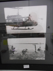
Photograph, Helicopter Operations
... Helicopter Operations...Two black and white Photograph of helicopter operations. Photo 1. Two troop carrying Hueys in flight Photo 2. ...Two Hueys on the ground deploying troops Helicopter Operations Photograph Photograph ...Two black and white Photograph of helicopter operations. Photo 1. Two troop carrying Hueys in flight Photo 2. Two Hueys on the ground deploying troopsphotograph, huey helicopter, uh-1h helicopter -
 Moorabbin Air Museum
Book - Helicopter operations, Basic Helcopter Handbook Federal Aviation Agency
... Helicopter operations...Helicopter Operations...Moorabbin Air Museum Moorabbin Airport 12 First Street Moorabbin melbourne Helicopter Operations Technical manual for private, commercial, & instructor pilots seeking a helicopter rating, circa 1965 Basic Helcopter Handbook Federal Aviation Agency Book Helicopter operations ...Technical manual for private, commercial, & instructor pilots seeking a helicopter rating, circa 1965non-fictionTechnical manual for private, commercial, & instructor pilots seeking a helicopter rating, circa 1965 -
National Vietnam Veterans Museum (NVVM)
Film - Film, Video, We were heroes - Vietnam, Vol. 3 - First Cavalry Division (Airmobile) in Vietnam; US Army Helicopter Operations in Vietnam; logistics in Vietnam (Pipeline to victory)
... We were heroes - Vietnam, Vol. 3 - First Cavalry Division (Airmobile) in Vietnam; US Army Helicopter Operations in Vietnam; logistics in Vietnam (Pipeline to victory)...Air Cavalry Division 1st - Film amd video adaptations We were heroes - Vietnam, Vol. 3 - First Cavalry Division (Airmobile) in Vietnam; US Army Helicopter Operations in Vietnam; logistics in Vietnam (Pipeline to victory) Film Film, Video ...united states. army. air cavalry division, 1st - film amd video adaptations -
National Vietnam Veterans Museum (NVVM)
Film - Film, DVD, We were heroes - Vietnam, Vol. 3:- First Cavalry Division (Airmobile) in Vietnam; US Army Helicopter Operations in Vietnam; logistics in Vietnam (Pipeline to victory) (2 copies)
... We were heroes - Vietnam, Vol. 3:- First Cavalry Division (Airmobile) in Vietnam; US Army Helicopter Operations in Vietnam; logistics in Vietnam (Pipeline to victory) (2 copies)...Air Cavalry Division 1st - Film amd video adaptations We were heroes - Vietnam, Vol. 3:- First Cavalry Division (Airmobile) in Vietnam; US Army Helicopter Operations in Vietnam; logistics in Vietnam (Pipeline to victory) (2 copies) Film Film, DVD ...united states. army. air cavalry division, 1st - film amd video adaptations -
 National Vietnam Veterans Museum (NVVM)
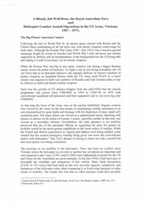
Document, A copy of A Bloody Job Well Done: the Royal Australian Navy and Helicopter Combat Assault Operations in the US Army, Vietnam, 1967-1971
... A copy of A Bloody Job Well Done: the Royal Australian Navy and Helicopter Combat Assault Operations in the US Army, Vietnam, 1967-1971....A copy of A Bloody Job Well Done: the Royal Australian Navy and Helicopter Combat Assault Operations in the US Army, Vietnam, 1967-1971. ...A copy of A Bloody Job Well Done: the Royal Australian Navy and Helicopter Combat Assault Operations in the US Army, Vietnam, 1967-1971. ...A copy of A Bloody Job Well Done: the Royal Australian Navy and Helicopter Combat Assault Operations in the US Army, Vietnam, 1967-1971. See media files for full story.royal australian navy, united states air force, dien bien phu, caribou, hmas sydney, united states army, vung tau, hmas melbourne, australian army training team vietnam (aattv), arvn, raaf, royal australian air force, 9 sqn, hmas penguin, ho chi minh trail, phuoc tuy province, mekong delta -
National Vietnam Veterans Museum (NVVM)
Film - Film, DVD, We were heroes - Vietnam: 1st Cavalry Division (Airmobile), 2002
... ...U.S. Army Helicopter operations - Vietnam...Vietnam War 1961-1975 -- Aerial operations American -- Film and video adapatations U.S. Army Helicopter operations - Vietnam First Cavalry Division (Airmobile) in Vietnam; US Army Helicopter Operatin in Vietnam: Logistics in Vietnam (Pipeline to victory). ...First Cavalry Division (Airmobile) in Vietnam; US Army Helicopter Operatin in Vietnam: Logistics in Vietnam (Pipeline to victory).united states. army. air cavalry division, 1st -- film amd video adaptations., vietnam war, 1961-1975 -- aerial operations, american -- film and video adapatations, u.s. army helicopter operations - vietnam -
Moorabbin Air Museum
Book - Australian aviation year books, Australian Aviation Yearbook 1970
... ...Helicopter operations...Australian aviation year books Aerial work operators Aero clubs & flying schools Aerodromes & airfields Aircraft movement & reporting stations Historical aircraft Aircraft production Aircraft register Airline operators domestic & internatiional Approved firms Army aviation Australian Fleet Air Arm Aviation associations Charter operators Dept of Civil Aviation 50 years of flight Helicopter operations Historical world flights History of Australian aviation Overseas aircraft companies RAAF RFDS Overview of Australia aviation for 1970 Australian Aviation Yearbook 1970 Book Australian aviation year books ...Overview of Australia aviation for 1970non-fictionOverview of Australia aviation for 1970aerial work operators, aero clubs & flying schools, aerodromes & airfields, aircraft movement & reporting stations, historical aircraft, aircraft production, aircraft register, airline operators domestic & internatiional, approved firms, army aviation, australian fleet air arm, aviation associations, charter operators, dept of civil aviation, 50 years of flight, helicopter operations, historical world flights, history of australian aviation, overseas aircraft companies, raaf, rfds -
 National Vietnam Veterans Museum (NVVM)
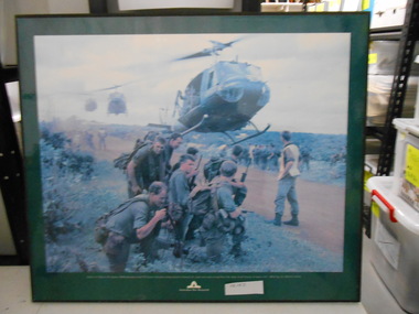
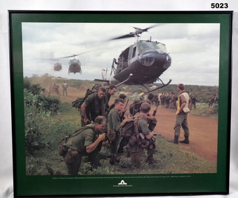
Photograph, Helicopter Boarding, 26/08/1967 12:00:00 AM
... helicopter...5 Platoon...Operation...Framed Coloured Photograph of soldiers of 5 Platoon B Company 7 RAR preparing to board a US Iroquois Helicopter during Operation Ulmarra The cordon and search of Lang Phuoc Mai Village Sth Vietnam on 26th August 1967...National Vietnam Veterans Museum (NVVM) 25 Veterans Drive Newhaven phillip-island-and-the-bass-coast 7 RAR Photograph Iroquois helicopter 5 Platoon Operation Ulmarra Lang Phuoc Mai Village Australian War Memorial Logo AWM Neg No EKN/67/130/VN Framed Coloured Photograph of soldiers of 5 Platoon B Company 7 RAR preparing to board a US Iroquois Helicopter during Operation Ulmarra The cordon and search of Lang Phuoc Mai Village Sth Vietnam on 26th August 1967 Helicopter Boarding Photograph Photograph AWM ...Framed Coloured Photograph of soldiers of 5 Platoon B Company 7 RAR preparing to board a US Iroquois Helicopter during Operation Ulmarra The cordon and search of Lang Phuoc Mai Village Sth Vietnam on 26th August 1967Australian War Memorial Logo AWM Neg No EKN/67/130/VN7 rar, photograph, iroquois helicopter, 5 platoon, operation ulmarra, lang phuoc mai village -
 Bendigo Military Museum
Print - PRINT, FRAMED
... Soldiers of 5 Platoon, B Company, 7 RAR, preparing to board VS Iroquois helicopters during operation Ulmarrah, the cordon and search of Lang Phuoc Hai Village, South Vietnam, 26 August 1967". ...Soldiers of 5 Platoon, B Company, 7 RAR, preparing to board VS Iroquois helicopters during operation Ulmarrah, the cordon and search of Lang Phuoc Hai Village, South Vietnam, 26 August 1967". ...Caption under print. Soldiers of 5 Platoon, B Company, 7 RAR, preparing to board VS Iroquois helicopters during operation Ulmarrah, the cordon and search of Lang Phuoc Hai Village, South Vietnam, 26 August 1967". Members of 5 Platoon, B Company, 7th Battalion, The Royal Australian Regiment (7RAR), just north of the village of Lang Phuoc Hai, beside Route 44 leading to Dat Do. United States Army Iroquois helicopters are landing to take them back to Nui Dat after completion of Operation Ulmarra, the cordon-and-search by 7RAR of the coastal village of Lang Phuoc Hai. Operation Ulmarra was conducted by 2nd Battalion, The Royal Australian Regiment (2RAR) and 7RAR with support elements. Left to right: Private (Pte) Peter Capp (kneeling); Pte Bob Fennell (leaning over, facing camera, with an ammunition belt for an M60 machine gun slung over his shoulder); Corporal Bob D'Arcy (partly obscured behind Fennell); Pte Neal Hasted (centre, front); Pte Ian Jury (partly obscured, centre, rear, holding rifle); Pte Colin Barnett (front, right, M60 ammunition belt on back, back of head to camera); Lance Corporal Stan Whitford (partly obscured behind Barnett); the helicopter marshal at right is Pte John Raymond Gould, 7RAR. The United States Army Iroquois UH-1D helicopter was operated by 2 Platoon, 162nd Assault Helicopter Company, 11th Combat Aviation Battalion. (Having achieved almost the status of an icon, this image was chosen for, and is etched on, the Australian Vietnam Forces National Memorial on Anzac Parade, Canberra, ACT, dedicated in October 1992). Source AWM Print donated and dedicated to 3789179 FRANK FRIGERIO, 5 Platoon, B Company, 7RAR. See also Cat No. 3543-3549.3Print - coloured print of a photograph depicting three helicopters coming in to land above a dirt road with several groups of soldiers in uniform with jungle vegetation in the background. Frame - black painted metal.See in context, historical - caption under print.prints, framed, accessories, vietnam war -
 National Vietnam Veterans Museum (NVVM)
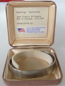
Ceremorial Object - MIA Bracelet - L/Cpl John Francis Gillespie, The Laeufers LIMA MIA-POW
... On 17 April 1971 Gillespie was serving as a helicopter medic during a 'dustoff' (helicopter medical evacuation) operation in the Long Hai hills in Phuoc Tuy province. ...On 17 April 1971 Gillespie was serving as a helicopter medic during a 'dustoff' (helicopter medical evacuation) operation in the Long Hai hills in Phuoc Tuy province. ...The last Australian soldier to be listed as missing in action was Lance Corporal John Francis Gillespie of 8 Field Ambulance. On 17 April 1971 Gillespie was serving as a helicopter medic during a 'dustoff' (helicopter medical evacuation) operation in the Long Hai hills in Phuoc Tuy province. Four South Vietnamese Regional Force soldiers had been injured by a mine explosion and the difficult terrain demanded a helicopter evacuation. But the Long Hai hills were an insecure landing zone. The caves and dense timber of the Long Hais had long harboured a major Viet Cong base area and the dustoff operation required the protection of helicopter gunships. As the first wounded soldier was being winched up, the hovering helicopter was hit by enemy machine-gun fire. It crashed to the ground and burst into flames. Although the crew escaped, Lance Corporal Gillespie and three other soldiers were engulfed in the fireball. A helicopter crewman, Corporal Robert Stephens, repeatedly entered the burning aircraft and tried in vain to rescue Gillespie, until being forced back by the flames. Stephens was later awarded the British Empire Medal for his courage. Gillespie's body could not be recovered from the burning wreckage which was reduced to slag by the fire. Private Gillespie was listed as missing in action, apparently on a technicality because his remains could not be found. The classification was subsequently altered to killed in action.Stainless steel open ended bracelet with missing serviceman's full name and date missing. In a buff square satin lined box.MIA John Francis Gillespie 17/04/71mia, john francis gillespie, l/cpl john francis gillespie, 3170244, royal australian army medical corps, 8th field ambulance, cpl robert stephens, killed in action -
Moorabbin Air Museum
Document (series) - Nomad Development Material - Collection of Vilem Gottlieb
... Fincher 1979 10 Bound book Nomad ASTA Nomad model N22S - Certification Report N22S2-21022 - Flight Test Certification Report - AF36 Documentation 1988 11 Bound book Nomad GAF GAF Project Report RN2/4 - Nomad N22 - Detail Specification - Part 1 Basic Aircraft 1973 12 Bound book Nomad GAF Nomad Aircraft - Model N22-B - With icing spray system fitted - Development flight test schedule 1978 13 Stapled book Nomad GAF N22B - Nomad Performance Summary for Air Taxi and Commercial Operations 14 Manila Folder Nomad Civil Aviation Authority (Commonwealth of Australia) Copy of Certificate of Approval for aeroplanes type known as GAF models N2, N22, N22B, N22C, N22S, N24 and N24A 1992 15 Nomad Photograph of a Nomad with what looks like smoke underneath 16 Nomad GAF Brochure - STRETCHED Nomad N24 17 Suspension folder General Motors - Allison Gas Turbine Operations Engineering Department Report No.11910A - Instructions for the use of a program, in the form of a source deck of digital computer cards, tape, or floppy diskette to calculate steady state performance of the Allison Gas Turbine Model 250-B17E Turboprop Engine 1987 18 General Motors - Allison Gas Turbine Operations Supplement 1 to the above 19 Fax - very feint - From: Woodward Governor Company Small Aircraft Controls - To: Hawker Pacific - About: propellor synchrophasing systems availability 1992 20 Various pages, some handwritten or faxed about engines, propellor synchronising, and installation charts 1987 21 Manila Folder Nomad Newspaper article: Another Nomad Scare 22 Bulldog Newspaper article: Undercarriage Jams on Test Flight - The Daily Telegraph 1976 23 Jetstream Photograph of a Jetstream 24 Nomad GAF/Department of Productivity Memo re Nomad Ground Training Certificate awarded to Vilem K Gottlieb 25 Avalon Memo congratulating V K Gottlieb on successfully passing the Avalon B17B Engine Course 1978 26 Nomad ASTA Aircraft Weighing Summary - N22B - VH-AUN 1992 27 ASTA/Litton Systems Canada Ltd Fax - very feint - USCS Radar Trials 1990 28 Gippsland Aeronautics Email trail GA18 Bill of Material 2011 29 ASTA Instrument of Appointment - delegate Patrick Larcey 2002 30 Certificate of Competency in Winching Operations for Endorsement in a Helicopter Winch Operator’s/Aircrewman’s Log Book 1986 31 CASA Email: Mod 953 SB 2008 32 Gippsland Aeronautics Email trail: Nomad Technical Publications - Flight manuals for the Mod N953 2011 33 Gippsland Aeronautics Publication “What’s News at GippsAero” Issue 13 October 2012 2011 34 A page from an illustrated parts catalogue - Figure 8 Flap Control, Actuation, Post-Mod N953 35 Nomad A page from a Nomad - Series N24 Maintenance Manual 36 Gippsland Aeronautics Email trail re BOM creation for GA18 2011 37 Nomad Nomad N24A - Draft list of composite parts and accompanying handwritten notes 38 Nomad Gippsland Aeronautics Nomad product support - Service bulletins 2009 39 Nomad Gippsland Aeronautics Email asking for document listing the major modifications and customer options 40 Nomad Gippsland Aeronautics Handwritten notes about spare parts 41 Jetstream Jetstream CEntral Jetstream 31 Commuter Performance Information 42 Nomad Avalon Aircraft Weighing Summary - N24A-60 - ZK-NMD 43 Photograph of a Learjet cockpit 44 Photograph of a cabin of an unknown aircraft - could be the Learjet in the previous photo 45 Manila Folder ASTA Newspaper article: ASTA bids for $500m Orion deal 46 Newspaper article: re Hornet fighter jet rescue helicopter 47 Newspaper article: ASTA returns profit despite poor times 48 Newspaper article: Government to sell ASTA 49 Newspaper employment ad: ASTA Defence - Integrated Logistics Support Personnel 50 Newspaper article: ASTA to cut staff 51 Newspaper employment ad: Test Pilot at the Flying Operations Airworthiness Division (DoT) 52 GAF Job application: Flight Test Observer (No.138) 1976 53 Australian High Commission Letter re recruitment for GAF position 1977 54 Australian High Commission Letter re interview for GAF position 1977 55 Australian High Commission Letter advising of successful application for GAF position 1977 56 Australian High Commission Letter re successful medical examination 1977 57 Australian High Commission Memos regarding start date in Australia 1977 58 Memos confirming appointment as Deputy Chief Flight Test Engineer 1969 59 Australian Department of Foreign Affairs International Message Form: Nomad Icing UK 1978 60 Australian Consolate Advice re interview for application to migrate to Australia 1977 61 GAF Copy of a job ad for Flight Development Engineer 1984 62 GAF Memo: expressing interest in the Flight Development Engineer position 1984 63 GAF Memo: acknowledgement of above memo expressing interest in the Flight Development Engineer position 1984 64 Menu: 94th Aero Squadron - 1st Pursuit Group - unsure of the specific event 65 Avalon Memo: GAF Helicopter Crew - Compensation/Insurance and Additional Payments 1986 66 Aeronautical Development Associates Ltd Letter and list of installation projects 1983 67 Certificate of Competency in Winching Operations for Endorsement in a Helicopter Winch Operator’s/Aircrewman’s Log Book - DoT Air Navigation Orders on Air Service Operations - Helicopter winching and rappelling operations 1986 68 ASTA Memo: appointment of George Stuart to the position of CEO 1987 69 ASTA Various letters and memos re termination of employment and retrenchment 70 GAF Duty Statement - Senior Technical Officer (Engineering) Grade 2 1973 71 Nomad ASTA Letter to Field Aviation Company Limited requesting support services as required for Nomad N22S-164 1988 72 GAF Letter to Avalon Workforce: re GAF ceasing operations on 30/6, recommencing operations as ASTA on 1/7 1987 73 GAF Attached to #72 a copy of a newspaper obituary - GAF passing away! ...Fincher 1979 10 Bound book Nomad ASTA Nomad model N22S - Certification Report N22S2-21022 - Flight Test Certification Report - AF36 Documentation 1988 11 Bound book Nomad GAF GAF Project Report RN2/4 - Nomad N22 - Detail Specification - Part 1 Basic Aircraft 1973 12 Bound book Nomad GAF Nomad Aircraft - Model N22-B - With icing spray system fitted - Development flight test schedule 1978 13 Stapled book Nomad GAF N22B - Nomad Performance Summary for Air Taxi and Commercial Operations 14 Manila Folder Nomad Civil Aviation Authority (Commonwealth of Australia) Copy of Certificate of Approval for aeroplanes type known as GAF models N2, N22, N22B, N22C, N22S, N24 and N24A 1992 15 Nomad Photograph of a Nomad with what looks like smoke underneath 16 Nomad GAF Brochure - STRETCHED Nomad N24 17 Suspension folder General Motors - Allison Gas Turbine Operations Engineering Department Report No.11910A - Instructions for the use of a program, in the form of a source deck of digital computer cards, tape, or floppy diskette to calculate steady state performance of the Allison Gas Turbine Model 250-B17E Turboprop Engine 1987 18 General Motors - Allison Gas Turbine Operations Supplement 1 to the above 19 Fax - very feint - From: Woodward Governor Company Small Aircraft Controls - To: Hawker Pacific - About: propellor synchrophasing systems availability 1992 20 Various pages, some handwritten or faxed about engines, propellor synchronising, and installation charts 1987 21 Manila Folder Nomad Newspaper article: Another Nomad Scare 22 Bulldog Newspaper article: Undercarriage Jams on Test Flight - The Daily Telegraph 1976 23 Jetstream Photograph of a Jetstream 24 Nomad GAF/Department of Productivity Memo re Nomad Ground Training Certificate awarded to Vilem K Gottlieb 25 Avalon Memo congratulating V K Gottlieb on successfully passing the Avalon B17B Engine Course 1978 26 Nomad ASTA Aircraft Weighing Summary - N22B - VH-AUN 1992 27 ASTA/Litton Systems Canada Ltd Fax - very feint - USCS Radar Trials 1990 28 Gippsland Aeronautics Email trail GA18 Bill of Material 2011 29 ASTA Instrument of Appointment - delegate Patrick Larcey 2002 30 Certificate of Competency in Winching Operations for Endorsement in a Helicopter Winch Operator’s/Aircrewman’s Log Book 1986 31 CASA Email: Mod 953 SB 2008 32 Gippsland Aeronautics Email trail: Nomad Technical Publications - Flight manuals for the Mod N953 2011 33 Gippsland Aeronautics Publication “What’s News at GippsAero” Issue 13 October 2012 2011 34 A page from an illustrated parts catalogue - Figure 8 Flap Control, Actuation, Post-Mod N953 35 Nomad A page from a Nomad - Series N24 Maintenance Manual 36 Gippsland Aeronautics Email trail re BOM creation for GA18 2011 37 Nomad Nomad N24A - Draft list of composite parts and accompanying handwritten notes 38 Nomad Gippsland Aeronautics Nomad product support - Service bulletins 2009 39 Nomad Gippsland Aeronautics Email asking for document listing the major modifications and customer options 40 Nomad Gippsland Aeronautics Handwritten notes about spare parts 41 Jetstream Jetstream CEntral Jetstream 31 Commuter Performance Information 42 Nomad Avalon Aircraft Weighing Summary - N24A-60 - ZK-NMD 43 Photograph of a Learjet cockpit 44 Photograph of a cabin of an unknown aircraft - could be the Learjet in the previous photo 45 Manila Folder ASTA Newspaper article: ASTA bids for $500m Orion deal 46 Newspaper article: re Hornet fighter jet rescue helicopter 47 Newspaper article: ASTA returns profit despite poor times 48 Newspaper article: Government to sell ASTA 49 Newspaper employment ad: ASTA Defence - Integrated Logistics Support Personnel 50 Newspaper article: ASTA to cut staff 51 Newspaper employment ad: Test Pilot at the Flying Operations Airworthiness Division (DoT) 52 GAF Job application: Flight Test Observer (No.138) 1976 53 Australian High Commission Letter re recruitment for GAF position 1977 54 Australian High Commission Letter re interview for GAF position 1977 55 Australian High Commission Letter advising of successful application for GAF position 1977 56 Australian High Commission Letter re successful medical examination 1977 57 Australian High Commission Memos regarding start date in Australia 1977 58 Memos confirming appointment as Deputy Chief Flight Test Engineer 1969 59 Australian Department of Foreign Affairs International Message Form: Nomad Icing UK 1978 60 Australian Consolate Advice re interview for application to migrate to Australia 1977 61 GAF Copy of a job ad for Flight Development Engineer 1984 62 GAF Memo: expressing interest in the Flight Development Engineer position 1984 63 GAF Memo: acknowledgement of above memo expressing interest in the Flight Development Engineer position 1984 64 Menu: 94th Aero Squadron - 1st Pursuit Group - unsure of the specific event 65 Avalon Memo: GAF Helicopter Crew - Compensation/Insurance and Additional Payments 1986 66 Aeronautical Development Associates Ltd Letter and list of installation projects 1983 67 Certificate of Competency in Winching Operations for Endorsement in a Helicopter Winch Operator’s/Aircrewman’s Log Book - DoT Air Navigation Orders on Air Service Operations - Helicopter winching and rappelling operations 1986 68 ASTA Memo: appointment of George Stuart to the position of CEO 1987 69 ASTA Various letters and memos re termination of employment and retrenchment 70 GAF Duty Statement - Senior Technical Officer (Engineering) Grade 2 1973 71 Nomad ASTA Letter to Field Aviation Company Limited requesting support services as required for Nomad N22S-164 1988 72 GAF Letter to Avalon Workforce: re GAF ceasing operations on 30/6, recommencing operations as ASTA on 1/7 1987 73 GAF Attached to #72 a copy of a newspaper obituary - GAF passing away! ...Donation from Anna Gottlieb -
 Bendigo Military Museum
Photograph - RA Svy Project C4 Aerodist Operation, Eastern Arnhem Land, NT, 1967
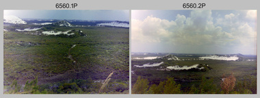
... helicopters had a limiting load carrying capacity of up to about 500 pounds. By comparison, one Aerodist team including two people weighed up to 1,500 pounds. Source: Royal Australian Survey Corps – Aerodist Years 1964-1975 by Peter Jensen. Refer to Item 9061.26P for more photos taken during this Aerodist survey operation...Helicopter (LOH) probably at Gove, NT. .30) - Photo, black & white, 1967. Panelled U337 survey station, visible as a white cross on aerial identification photo. RA Svy Project C4 Aerodist Operation ...This is a set of 30 photographs of Royal Australian Survey Corps (RA Svy) personnel from Central Comd Fd Svy Unit (Adelaide) on Aerodist survey operation - Project C4 in Eastern Arnhem Land, Northern Territory in 1967. Photos of personnel were taken either at the operations base at Numbulwar or the main base at Gove (Nhulunbuy). RA Svy conducted nineteen Aerodist operations for 12 years from 1964 to 1975. Aerodist MRC2 was a tellurometer-based system adapted for aircraft to accurately measure distances between non-intervisible ground survey stations, using the aircraft as an intermediate station. Lower order geodetic results could be achieved by survey network trilateration. The measured distances between stations formed survey networks from which each station’s latitude and longitude was computed. Aerodist MRC2 was RA Svy’s major horizontal control survey tool for mainly medium scale topographic mapping (scale 1:100,000 Class A being spatially accurate to within 50 metres) in PNG, northern NT, north-west WA, Kalimantan Barat (West) Indonesia, Sumatra Indonesia, Gulf of Carpentaria and Cape York, QLD. In 1967, the Aerodist MRC2 Master equipment was installed in the aircraft featured in this set of photos, Executive Air Services’ (Essendon VIC) Grand Aero Commander VH-EXX. It was the same aircraft type and company contracted to Division of National Mapping for Aerodist MRC2 surveys. From July to October 1967 the aircraft was attached to Central Comd Fd Svy Unit (Adelaide - Major Don Ridge) on Project C4 eastern-Arnhem Land NT, where 317 Aerodist lines measuring 17,300 line miles were successfully completed. This was the most productive Aerodist project thus far. The most common helicopter used by RA Svy up to 1972 was the civilian Bell 47G-2 and the Sioux Light Observation Helicopters (LOH), the Australian Army’s equivalent featured in this photo set. These light observation helicopters had a limiting load carrying capacity of up to about 500 pounds. By comparison, one Aerodist team including two people weighed up to 1,500 pounds. Source: Royal Australian Survey Corps – Aerodist Years 1964-1975 by Peter Jensen. Refer to Item 9061.26P for more photos taken during this Aerodist survey operation.This is a set of 30 photographs of Royal Australian Survey Corps (RA Svy) personnel on Aerodist survey operations in Eastern Arnhem Land, Northern Territory in 1967. The photographs are on 35mm negative film and scanned at 96 dpi. They are part of the Army Survey Regiment’s Collection. .1) to .4) - black & white, 20th August 1967, Project C4 Aerodist Operations Base - Numbulwar, NT. .5) - Photo, black & white, 1967. Probable wrecked Indonesian fishing vessel. .6) to .8) - Photo, black & white, 1967. Unidentified survey operations base, L to R: unidentified personnel. .9) - Photo, black & white, 1967. Unidentified survey operations base, unidentified soldier driving a Haflinger 4x4 Light utility vehicle. .10) - Photo, black & white, 1967. Unidentified survey operations base, L to R: unidentified technician. .11) - Unidentified technician reading two survey altimeters to compute corrections to the measured distances for atmospheric refraction and to compute the sea level distances from the slope distances aircraft to the ground stations. .12) - Photo, black & white, 1967. Survey operations base, L to R: unidentified (x3), W01 Pat Wood BEM, unidentified. .13) to .16) - Photo, black & white, 1967. Unidentified personnel operating remote Aerodist MRC2 ground instruments. .17) to .18) - Photo, black & white, 1967. Unknown RA Svy office location. .19) to .20) - Photo, black & white, 1967. Aerodist MRC2 Master equipment. .21) to .22) - Photo, black & white, 1967. Aero Commander VH-EXX probably at Gove, NT, Central Comd Fd Svy Unit (Adelaide) – OC Major Don Ridge. .23) to .25) - Photo, black & white, 1967. Aero Commander VH-EXX probably at Gove, NT. Unidentified personnel. .26) - Photo, black & white, 1967. Aero Commander VH-EXX probably at Gove, NT. Aerodist antenna pods are visible on the aircraft. .27) to .29) - Photo, black & white, 1967. Australian Army Sioux Light Observation Helicopter (LOH) probably at Gove, NT. .30) - Photo, black & white, 1967. Panelled U337 survey station, visible as a white cross on aerial identification photo..1P to .2P – date and location on edge of film negative. .5P to .28P – no annotations .29P - annotated in white ‘RW-JEP Gove NT’ .30P - annotated in white ‘U337 Spool No1 Jun67’royal australian survey corps, rasvy, army survey regiment, army svy regt, fortuna, asr, aerodist, surveying, central comd fd svy unit -
 Bendigo Military Museum
Photograph - Royal Australian Survey Corps Surveyors in the Field – PNG, 1962
... Unloading survey operation stores from a Landing Ship Medium (LSM) at Dogera, Milne Bay Province, PNG. .2) & .3) - Photo, colour, 1962. Hired civilian helicopter...helicopter transport of survey parties revolutionised transport in remote areas. Royal Australian Survey Corps RASvy Army Survey Regiment ASR Army Svy Regt Fortuna surveying .1P to .4P annotated on back – personnel names, the year and the location. This is a set of four photographs of surveyors and support staff in the field undertaking duties in PNG in 1962. The photographs were printed on photographic paper and are part of the Army Survey Regiment’s Collection. The photographs were scanned at 300 dpi. .1) - Photo, colour, 1962. Unloading survey operation ...This is a set of four photographs of surveyors and support staff in the field undertaking duties in Dogera, Milne Bay Province and Kerema, Gulf Province of PNG in 1962. The surveyors were employed in the establishment of mapping and geodetic control. In this era surveyors used theodolites to observe horizontal and vertical angles and tellurometers to measure base line distances between survey stations. From 1957 helicopter transport of survey parties revolutionised transport in remote areas.This is a set of four photographs of surveyors and support staff in the field undertaking duties in PNG in 1962. The photographs were printed on photographic paper and are part of the Army Survey Regiment’s Collection. The photographs were scanned at 300 dpi. .1) - Photo, colour, 1962. Unloading survey operation stores from a Landing Ship Medium (LSM) at Dogera, Milne Bay Province, PNG. .2) & .3) - Photo, colour, 1962. Hired civilian helicopter Bell 47G-2 helicopters operating at at Dogera, Milne Bay Province, PNG. .4) - Photo, colour, 1962. Survey party at survey station located near Kerema, Gulf Province southern PNG. L to R: Dave Owens, Keith Broadbent, with local villagers in background..1P to .4P annotated on back – personnel names, the year and the location. royal australian survey corps, rasvy, army survey regiment, asr, army svy regt, fortuna, surveying -
 Bendigo Military Museum
Photograph - RA Svy Project C4 Aerodist Operation, Eastern & Western Arnhem Land, NT, 1967, 1968
... helicopters had a limiting load carrying capacity of up to about 500 pounds. By comparison, one Aerodist team including two people weighed up to 1,500 pounds. In 1968, after completion of the Kimberley Aerodist Operation...operations in Eastern Arnhem Land, Northern Territory in 1967 and Western Arnhem Land, Northern Territory in 1968. The photographs are on 35mm negative film and scanned at 96 dpi. They are part of the Army Survey Regiment’s Collection. .1) to .2) – Photo, black & white, 1968, unidentified soldier with an opened can of food, possibly bully beef. .3) – Photo, black & white, 15 Aug 1968, aerial view of terrain taken from a helicopter in vicinity of MILINGIMBI SIERRA. .4) – Photo, black & white, 1967, aerial view of an island taken from a helicopter. .5) & .6) – Photo, black & white, 1967, unidentified soldier driving a Haflinger 4x4 Light utility vehicle with trailer. .7) – Photo, black & white, 1967, unidentified surveyors taking vertical measurements with a leveling instrument and staff. .8) – Photo, black & white, 1967, Australian Army Sioux Light Observation Helicopter (LOH) with float removed. .9) to .11) – Photo, black & white, 1967, Australian Army Sioux Light Observation Helicopter (LOH) with floats. .12) – Photo, black & white, 1967, civilian Bell 47G-2 helicopter (Australian Army Sioux LOH equivalent) refuelled. .13) – Photo, black & white, 1967, survey station on coastline surrounded by white plastic aerial photographic identification panels lined with rocks. .14) & .15) – Photo, black & white, 1967, soldier (possibly a signaller from RA Sigs) operating a radio. .16) – Photo, black & white, 1967, Central Comd Fd Svy Unit Operations Section tent, Main Base Gove (Nhulunbuy) L to R: SPR Harry Dunn, WO1 Pat Wood BEM. .17) – Photo, black & white, 1967, Central Comd Fd Svy Unit Operations Section tent, Main Base Gove (Nhulunbuy) L to R: unidentified, WO1 Pat Wood BEM. .18) – Photo, black & white, 1967, Central Comd Fd Svy Unit Operations Section, Main Base Gove (Nhulunbuy), unidentified Australian Army Catering Corps cook preparing meals. .19) – Photo, black & white, 1967, Central Comd Fd Svy Unit Operations Section, Main Base Gove (Nhulunbuy) mess tent in readiness for meals. .20) – Photo, black & white, 1967, Bank of batteries in transit boxes undergoing recharging using generators. .21) – Photo, black & white, 1967, A topographic survey identification plaque set in a concrete block being weighed using a set of scales hanging from slaughtering gallows. .22) – Photo, black & white, 1967, CPL (Geoff or Gary) Larkin operating the remote Aerodist MRC2 ground instrument at Veronica Island, located north of Nhulunbuy. .23) – Photo, black & white, 1967, L to R: CPL (Geoff or Gary) Larkin with unidentified surveyor operate the remote Aerodist MRC2 ground instrument at Venica Island, located north of Nhulunbuy. .24) & .25 – Photo, black & white, 1967, The Aerodist MRC2 Remote antenna. .26) – Photo, black & white, 1967, The Aerodist MRC2 Remote antenna....helicopters had a limiting load carrying capacity of up to about 500 pounds. By comparison, one Aerodist team including two people weighed up to 1,500 pounds. In 1968, after completion of the Kimberley Aerodist Operation ...This is a set of 26 photographs of Royal Australian Survey Corps (RA Svy) personnel from Central Comd Fd Svy Unit (Adelaide) on Aerodist survey operation - Project C4 in Eastern Arnhem Land, Northern Territory in 1967 (photos .4P to .26P) and in Western Arnhem Land, Northern Territory in 1968 (photos .1P to .3P). Photos of personnel were taken either at the operations base at Numbulwar or the main base at Gove (Nhulunbuy). RA Svy conducted nineteen Aerodist operations for 12 years from 1964 to 1975. Aerodist MRC2 was a tellurometer-based system adapted for aircraft to accurately measure distances between non-intervisible ground survey stations, using the aircraft as an intermediate station. Lower order geodetic results could be achieved by survey network trilateration. The measured distances between stations formed survey networks from which each station’s latitude and longitude was computed. Aerodist MRC2 was RA Svy’s major horizontal control survey tool for mainly medium scale topographic mapping (scale 1:100,000 Class A being spatially accurate to within 50 metres) in PNG, northern NT, north-west WA, Kalimantan Barat (West) Indonesia, Sumatra Indonesia, Gulf of Carpentaria and Cape York, QLD. In 1967, the Aerodist MRC2 Master equipment was installed in the aircraft featured in this set of photos, Executive Air Services’ (Essendon VIC) Grand Aero Commander VH-EXX. It was the same aircraft type and company contracted to Division of National Mapping for Aerodist MRC2 surveys. From July to October 1967 the aircraft was attached to Central Comd Fd Svy Unit (Adelaide - Major Don Ridge) on Project C4 eastern-Arnhem Land NT, where 317 Aerodist lines measuring 17,300 line miles were successfully completed. This was the most productive Aerodist project thus far. The most common helicopter used by RA Svy up to 1972 was the civilian Bell 47G-2 and the Sioux Light Observation Helicopters (LOH), the Australian Army’s equivalent featured in this photo set. These light observation helicopters had a limiting load carrying capacity of up to about 500 pounds. By comparison, one Aerodist team including two people weighed up to 1,500 pounds. In 1968, after completion of the Kimberley Aerodist Operation project, the Aerodist system in VH-EXX was immediately deployed to western-Arnhem Land NT for Central Comd Fd Svy Unit (Adelaide - Major Don Ridge) to complete the mapping control across northern NT from mid-July to October. The Aerodist MRC2 Remote antenna seen in Photos .24P to .26P is mounted on a 20 foot pole tower. The antenna direction was controlled by wires/ropes to the two arms under the dish at right angles. The antenna elevation could be changed to the vertical for aircraft height checks as seen in photo .25P. Source: Royal Australian Survey Corps – Aerodist Years 1964-1975 by Peter Jensen. Refer to Item 6449.30P for more photos taken during these Aerodist survey operations.This is a set of 26 photographs of Royal Australian Survey Corps (RA Svy) personnel on Aerodist survey operations in Eastern Arnhem Land, Northern Territory in 1967 and Western Arnhem Land, Northern Territory in 1968. The photographs are on 35mm negative film and scanned at 96 dpi. They are part of the Army Survey Regiment’s Collection. .1) to .2) – Photo, black & white, 1968, unidentified soldier with an opened can of food, possibly bully beef. .3) – Photo, black & white, 15 Aug 1968, aerial view of terrain taken from a helicopter in vicinity of MILINGIMBI SIERRA. .4) – Photo, black & white, 1967, aerial view of an island taken from a helicopter. .5) & .6) – Photo, black & white, 1967, unidentified soldier driving a Haflinger 4x4 Light utility vehicle with trailer. .7) – Photo, black & white, 1967, unidentified surveyors taking vertical measurements with a leveling instrument and staff. .8) – Photo, black & white, 1967, Australian Army Sioux Light Observation Helicopter (LOH) with float removed. .9) to .11) – Photo, black & white, 1967, Australian Army Sioux Light Observation Helicopter (LOH) with floats. .12) – Photo, black & white, 1967, civilian Bell 47G-2 helicopter (Australian Army Sioux LOH equivalent) refuelled. .13) – Photo, black & white, 1967, survey station on coastline surrounded by white plastic aerial photographic identification panels lined with rocks. .14) & .15) – Photo, black & white, 1967, soldier (possibly a signaller from RA Sigs) operating a radio. .16) – Photo, black & white, 1967, Central Comd Fd Svy Unit Operations Section tent, Main Base Gove (Nhulunbuy) L to R: SPR Harry Dunn, WO1 Pat Wood BEM. .17) – Photo, black & white, 1967, Central Comd Fd Svy Unit Operations Section tent, Main Base Gove (Nhulunbuy) L to R: unidentified, WO1 Pat Wood BEM. .18) – Photo, black & white, 1967, Central Comd Fd Svy Unit Operations Section, Main Base Gove (Nhulunbuy), unidentified Australian Army Catering Corps cook preparing meals. .19) – Photo, black & white, 1967, Central Comd Fd Svy Unit Operations Section, Main Base Gove (Nhulunbuy) mess tent in readiness for meals. .20) – Photo, black & white, 1967, Bank of batteries in transit boxes undergoing recharging using generators. .21) – Photo, black & white, 1967, A topographic survey identification plaque set in a concrete block being weighed using a set of scales hanging from slaughtering gallows. .22) – Photo, black & white, 1967, CPL (Geoff or Gary) Larkin operating the remote Aerodist MRC2 ground instrument at Veronica Island, located north of Nhulunbuy. .23) – Photo, black & white, 1967, L to R: CPL (Geoff or Gary) Larkin with unidentified surveyor operate the remote Aerodist MRC2 ground instrument at Venica Island, located north of Nhulunbuy. .24) & .25 – Photo, black & white, 1967, The Aerodist MRC2 Remote antenna. .26) – Photo, black & white, 1967, The Aerodist MRC2 Remote antenna.The following photos are annotated in black ink on edge of film negative: .3P – ’15 Aug ’68, 2000’, 1-C18 ’68 MILINGIMBI SIERRA’ .4P – ’U462’ .8P – ‘1-C3/67 Float Removed’ .13P – ‘U477 10-C3/67 .20P - ‘2-C3/67 Bank of Chargers’ .21P - ‘3-C3/67 Gallows & Scales’ .22P - ‘0462 VERONICA ISLAND NT, CPL Larkin’ .23P - ‘0462 VERONICA ISLAND NT’ .24P - ‘4-C3/67 20’ Aerodist Tower’ .25P - ‘5-C3/67 20’ Aerodist Tower’ .26P - ‘6-C3/67 20’ Aerodist Tower’royal australian survey corps, rasvy, army survey regiment, army svy regt, fortuna, asr, aerodist, surveying, central comd fd svy unit -
 Bendigo Military Museum
Administrative record - Application of Light Aircraft to Royal Australian Survey Corps Survey Operations - MAJ LB Sprenger (RASvy) 1957, Major LB Sprenger (RASvy), November 1957
... The results were so successful that funds were made available to RASvy for operation of light aircraft for survey purposes in the financial year 1958/59. For a number of years the US and Canadian Armies had made significant use of helicopters for survey purposes, this is the Australian experience. ...The results were so successful that funds were made available to RASvy for operation of light aircraft for survey purposes in the financial year 1958/59. For a number of years the US and Canadian Armies had made significant use of helicopters for survey purposes, this is the Australian experience. ...Application of Light Aircraft to Royal Australian Survey Corps Survey Operations - MAJ LB Sprenger (RASvy) 1957. This is a report to determine if light aircraft was suitable and financially beneficial for use in Royal Australian Survey Corps Survey Operations. The results were so successful that funds were made available to RASvy for operation of light aircraft for survey purposes in the financial year 1958/59. For a number of years the US and Canadian Armies had made significant use of helicopters for survey purposes, this is the Australian experience. RASvy extensively used light aircraft for survey operations following this experience. MAJ LB Sprenger was later promoted and as LtCol LB Sprenger MBE he was the Commanding Officer of the Army Survey Regiment, Bendigo in 1969/70 and passed away during that appointment.A 23 x Foolscap page report of typed text, held together by staples and an ARNOS fastenerroyal australian survey corps, rasvy, fortuna, army survey regiment, army svy regt, asr -
 Bendigo Military Museum
Administrative record - Royal Australian Survey Corps - Planning for Field Survey Operations for 1:250,000 - LtCol JK Herridge (RASvy) 1960, LtCol JB Herridge (RASvy), April 1960
... This 13 x page document contains notes on planning for RASvy Field Survey Operations in Northern Command during 1958 and 1959 with helicopter support available for field operations for 1:250,000 mapping. ...Bendigo Military Museum 37 - 39 Pall Mall Bendigo goldfields This 13 x page document contains notes on planning for RASvy Field Survey Operations in Northern Command during 1958 and 1959 with helicopter support available for field operations for 1:250,000 mapping. ...This 13 x page document contains notes on planning for RASvy Field Survey Operations in Northern Command during 1958 and 1959 with helicopter support available for field operations for 1:250,000 mapping. The Document was written by LtCol JB Herridge (RASvy) at the School of Military Survey Balcombe April 1960.13 x foolscap pages of typed text, stapled and four holed punchedHand written "53" in top RH cornerroyal australian survey corps, rasvy, fortuna, army survey regiment, army svy regt, asr, school of military survey, sms -
 Bendigo Military Museum
Administrative record - Royal Australian Survey Corps - Central Command Operation Order C/1/61 Northern Territory 1961, DAD Svy, HQ Central Command , Keswick Barracks, SA, 1961
... The Operation Order details the tasks for the 6 x Officers (or equivalent) and 34 x OR's (or equivalent) and the support that was allocated including Frigate HMAS Gasgoyne, LSM landing craft, Trucks amphibian (DUKW), Helicopter and Cessna aircraft....The Operation Order details the tasks for the 6 x Officers (or equivalent) and 34 x OR's (or equivalent) and the support that was allocated including Frigate HMAS Gasgoyne, LSM landing craft, Trucks amphibian (DUKW), Helicopter and Cessna aircraft. ...This is a Central Command Operation Order for the Royal Australian Survey Corps to conduct a Survey Operation in Northern Territory in 1961. The task is to acquire Survey Control for the production of maps coving the following 1:250 000 map areas of Alligator River, Mt Evelyn, Coburg Peninsula, (including the offshore Islands, Melville Island and Bathurst Island. The Operation Order details the tasks for the 6 x Officers (or equivalent) and 34 x OR's (or equivalent) and the support that was allocated including Frigate HMAS Gasgoyne, LSM landing craft, Trucks amphibian (DUKW), Helicopter and Cessna aircraft.A 11 x page foolscap size paper report and 1 x foldout map Annex held together with a paper clip. Two hole punched.Hand written File Number in top RH Corner "101-310-4". Distribution stamp in top LH Corner. Hand written No7 in Top RH Corner.royal australian survey corps, rasvy, fortuna, army survey regiment, army svy regt -
 Bendigo Military Museum
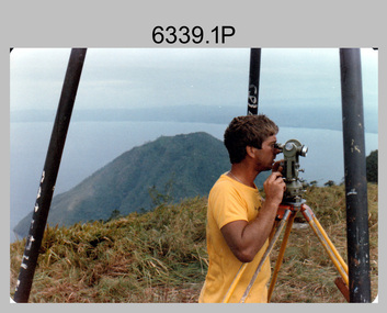
Photograph - Royal Australian Survey Corps personnel on survey operations in PNG and possibly Indonesia, c1975
... After No. 9 Squadron (9SQN) RAAF (Iroquois helicopters) withdrew with the Australian force from Vietnam in December 1971, RAAF supported RA Svy operations with the UH-1H Iroquois helicopter for tasks of transport and resupply of survey teams. ...After No. 9 Squadron (9SQN) RAAF (Iroquois helicopters) withdrew with the Australian force from Vietnam in December 1971, RAAF supported RA Svy operations with the UH-1H Iroquois helicopter for tasks of transport and resupply of survey teams. ...This is a set of two photographs of Royal Australian Survey Corps and RAAF personnel on survey operations in PNG and possibly Indonesia circa 1975. The identified surveyor - Peter Presser served 20 years in the Australian Regular Army from 1970 to 1990. The UH-1H Iroquois helicopter (serial number partially obscured) appearing in photo 6339.2P was probably A2-379. From 1957 helicopter transport of survey parties revolutionised transport in remote areas. The most common helicopter used by the Royal Australian Survey Corps (RA Svy) up to 1972 was the civilian Bell 47G-2 and the Sioux Light Observation Helicopters (LOH), the Australian Army’s equivalent. These light observation helicopters had a limiting load carrying capacity of up to about 500 pounds. By comparison, one Aerodist team including two people weighed up to 1,500 pounds. After No. 9 Squadron (9SQN) RAAF (Iroquois helicopters) withdrew with the Australian force from Vietnam in December 1971, RAAF supported RA Svy operations with the UH-1H Iroquois helicopter for tasks of transport and resupply of survey teams. The UH-1H was capable of carrying at least three times that of the smaller Bell 47G-2/Sioux LOH helicopter and could also winch personnel and stores into difficult locations. A2-379 crashed killing the aircraft captain (FLTLT Ralph Taylor 9SQN) on impact and seriously injuring four near Wamena, Irian Jaya, Indonesia on survey Operation Cenderawasih 1977 (supporting 2 Fd Svy Sqn – Doppler satellite survey). Source: Royal Australian Survey Corps – Aerodist Years 1964-1975 by Peter Jensen.This is a set of two photographs of Royal Australian Survey Corps and RAAF personnel on survey operations in PNG and possibly Indonesia circa 1975. The photographs were printed on photographic paper and are part of the Army Survey Regiment’s Collection. The photographs were scanned at 300 dpi. .1) - Colour, black & white, c1975, Peter Presser undertaking survey observations in PNG with a Wild T2 Theodolite. .2) - Photo, black & white, c1975. Survey operations L to R: unidentified (x2), Peter Presser, unidentified. .1P and .2P – No annotations. royal australian survey corps, rasvy, army survey regiment, army svy regt, fortuna, asr -
 Bendigo Military Museum
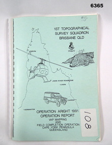
Administrative record - Royal Australian Survey Corps Report on Operation Aright 91 conducted by 1 Field Survey Squadron 1991, 1 Fd Svy Sqn, 7 Oct 1991
... Operation covered the 1:250,000 Map area of SD54-16 Hann River and SE54-7 Normanton. Royal Australian Survey Corps RASvy Fortuna Army Survey Regiment Army Svy Regt ASR Cover Hand annotated "ASS 108" (Air Survey Sqn, copy 108) Pale Blue cover with motifs of North Queensland, crocodile, RASvy Corps Badge, Army Helicopter and Land rover. ...Royal Australian Survey Corps Operation Aright 91 (Field Completion) was a Field Verification and Vital Assets Protection (VAP) Mapping Operation conducted in Far North Queensland during the period 18 Jun - 29 Jul 1991 by 1 Fd Svy Sqn. The Operation covered the 1:250,000 Map area of SD54-16 Hann River and SE54-7 Normanton.Pale Blue cover with motifs of North Queensland, crocodile, RASvy Corps Badge, Army Helicopter and Land rover. Contains an A4 paper report of typed pages and diagrams secured by a plastic binder.Cover Hand annotated "ASS 108" (Air Survey Sqn, copy 108)royal australian survey corps, rasvy, fortuna, army survey regiment, army svy regt, asr -
 Bendigo Military Museum
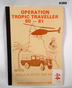
Administrative record - Operation Tropic Traveller 80 - 81 1 Field Survey Squadron, 1981
... Bendigo Military Museum 37 - 39 Pall Mall Bendigo goldfields Project report, Operation Tropic Traveller 1980/81 was mounted to field complete the North Queensland Tac map area during the periods 25 Feb to 11 Nov 1980 and 3 Mar to 13 Oct 1981 1 Field Survey Squadron 1 FD Svy Sqn Royal Australian Survey Corps Buff colored, A4 Folder, Mosaic in brown of Nth Qld, Helicopter, Corps badges, Land rover. ...Project report, Operation Tropic Traveller 1980/81 was mounted to field complete the North Queensland Tac map area during the periods 25 Feb to 11 Nov 1980 and 3 Mar to 13 Oct 1981 Buff colored, A4 Folder, Mosaic in brown of Nth Qld, Helicopter, Corps badges, Land rover.1 field survey squadron, 1 fd svy sqn, royal australian survey corps -
 Bendigo Military Museum
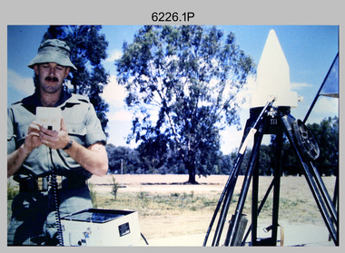
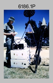
Photograph - Demonstration of TI4100 GPS Receiver, Royal Australian Survey Corps, c1988
... operation of Global Positioning System equipment in c1988. The photos were probably taken at the School of Military Survey (SMS), Bonegilla, VIC. Texas Instruments TI4100 portable Global Positioning System (GPS) geodetic receivers were introduced from 1986–1988. The GPS receivers and Ferranti FILS3 helicopter...operation of Global Positioning System equipment in c1988. The photos were probably taken at the School of Military Survey (SMS), Bonegilla, VIC. Texas Instruments TI4100 portable Global Positioning System (GPS) geodetic receivers were introduced from 1986–1988. The GPS receivers and Ferranti FILS3 helicopter ...This is a set of four photographs of WO2 Graham Ragless from the Royal Australian Survey Corps demonstrating the operation of Global Positioning System equipment in c1988. The photos were probably taken at the School of Military Survey (SMS), Bonegilla, VIC. Texas Instruments TI4100 portable Global Positioning System (GPS) geodetic receivers were introduced from 1986–1988. The GPS receivers and Ferranti FILS3 helicopter and vehicle mounted Inertial Positioning System (IPS) replaced the TRANSIT satellite receivers. The equipment was deployed to establish the baseline for a GPS controlled air camera and photogrammetric system to significantly reduce the requirement for ground survey to accurately control air photography for topographic mapping. Personnel from the four field survey squadrons at this time were trained at the SMS to operate the TI4100 receivers. Field survey operations using GPS and IPS equipment followed in the late 1980s. This technology is described in more detail in the RA Svy booklet titled An Introduction to Topographic Mapping. See record ID - 6010. WO2 Graham Ragless progressed to the rank of WO1 and was appointed as RSM of the Army Survey Regiment from 1990 to 1992. Refer to item 6186.2P for more photographs of WO2 Graham Ragless demonstrating the TI4100.This is a set of four photographs of a technician from the Royal Australian Survey Corps demonstrating the operation of Global Positioning System equipment in c1988. Colour photos are on 35mm slide film and were scanned at 96 dpi. .1) to .4) - Photo, colour, c1988, WO2 Graham Ragless demonstrating the operation of a TI4100 GPS receiverThere are no annotations.royal australian survey corps, rasvy, army survey regiment, army svy regt, fortuna, asr, surveying -
 Bendigo Military Museum
Photograph - Royal Australian Survey Corps Aerial Surveys, c1980
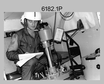
... helicopters used for observation, utility, and direct fire support. It was identified by RA Svy in the mid-1970s that considerable time was lost in replacing unserviceable remote equipment by road. Therefore Aerodist operations...An Australian Army Pilatus Porter and unidentified personnel, used by RA Svy on air survey and map field checking operations. .9) - Photo, colour, c1980s. An Australian Army Kiowa helicopter supporting a field survey party undertaking Magnavox AN/PRR-14 portable Doppler satellite observations. ...helicopters used for observation, utility, and direct fire support. It was identified by RA Svy in the mid-1970s that considerable time was lost in replacing unserviceable remote equipment by road. Therefore Aerodist operations ...This is a set of nine photographs of technicians from the Royal Australian Survey Corps operating aerial surveys equipment c1980s. In photo .1P, CPL Steve Gloster was operating a RC10 air survey camera mounted in an Australian Army Pilatus Porter aircraft. The Wild RC10 super wide-angle air survey cameras were first introduced in 1971, were equipped with virtual distortion free lenses for supplementary, spot and special photography. In photo .2P, Roger Rees was operating Air Profile Recorder (APR) equipment. it was possibly taken during OP NERVOSE 84, sometime between June – August 1984 when based in Ngukurr, Northern Territory. The APR was operated at this time in unison with an RC10 camera. In 1963 the Royal Australian Survey Corps introduced the radar airborne profile recorder (Canadian Applied Research Ltd, Mark V, Airborne Profiler Recorder) was introduced for 1:100,000 mapping to replace terrain heighting by aneroid barometry. Later in 1974-1975, the Australian developed WREMAPS II airborne laser terrain profile recorder was introduced. In photo .3P, Neil Jones appears at the door of Airsearch Beechcraft Queen Air aircraft, Registration / Serial VH-MWX. This aircraft was typically used by RA Svy on air survey operations flying mission with Aerodist, APR and RC10 camera equipment. The Australian Army’s Pilatus Porter (short take-off and landing turbo propeller) was also equipped with a Wild RC10 aerial mapping camera for identification photography. The Pilatus Porter was also used on RA Svy’s map field checking operations. Photo .9P was taken at a survey station at an unknown location. In this photo an Australian Army Kiowa Light Observation Helicopter (LOH) is supporting a field survey party undertaking Magnavox AN/PRR-14 portable Doppler satellite observations. The satellite receiver’s antenna is plumbed over the survey ground mark surrounded by white plastic panels. The panels were used to identify the survey station on aerial photography. Introduced in 1974–1975, the Magnavox AN/PRR-14 portable Doppler satellite (US Navy Navigation Satellite System – TRANSIT) receivers and computing system provided independent three-dimensional point positions anywhere in the world, anytime, in any weather accurate to about 1.5metres with precise satellite ephemerides. The Bell OH-58 Kiowa LOH was a family of military helicopters used for observation, utility, and direct fire support. It was identified by RA Svy in the mid-1970s that considerable time was lost in replacing unserviceable remote equipment by road. Therefore Aerodist operations (pre-dating satellite receiver operations) were fully supported by Army’s Kiowa LOH aircraft. This is a set of nine photographs of technicians from the Royal Australian Survey Corps operating aerial surveys equipment c1980s. .1P to .3P, .5P to .9P - Colour and black and white photos on photographic paper and scanned at 300 dpi. .4P - Colour photo on 35mm slide film and scanned at 96 dpi. .1) & .2) - Photo, black & white, c1980s, CPL Steve Gloster operating an RC10 air camera. .3) - Photo, colour, 1984, Roger Rees operating Air Profile Recorder (APR) equipment. .4) - Photo, colour, c1980s, Neil Jones at the door of an Airsearch Beechcraft Queen Air aircraft, typically used by RA Svy on air survey operations. .5) - Photo, colour, c1980s. A Beechcraft King Air aircraft, also used by RA Svy on air survey operations. .6) - Photo, colour, c1980s. An Australian Army Pilatus Porter, used by RA Svy on air survey and map field checking operations. SGT Peter Mustart is possibly in the foreground. .7) to .8) - Photo, colour, c1980s. An Australian Army Pilatus Porter and unidentified personnel, used by RA Svy on air survey and map field checking operations. .9) - Photo, colour, c1980s. An Australian Army Kiowa helicopter supporting a field survey party undertaking Magnavox AN/PRR-14 portable Doppler satellite observations. There are biro marks on photos .4P to .9Proyal australian survey corps, rasvy, army survey regiment, asr, fortuna, aerial surveys -
 Bendigo Military Museum
Photograph - Demonstration of TI4100 GPS Receiver, Royal Australian Survey Corps, c1988
... operation of Global Positioning System equipment in c1988. The photos were probably taken at the School of Military Survey (SMS), Bonegilla, VIC. Texas Instruments TI4100 portable Global Positioning System (GPS) geodetic receivers were introduced from 1986–1988. The GPS receivers and Ferranti FILS3 helicopter...operation of Global Positioning System equipment in c1988. The photos were probably taken at the School of Military Survey (SMS), Bonegilla, VIC. Texas Instruments TI4100 portable Global Positioning System (GPS) geodetic receivers were introduced from 1986–1988. The GPS receivers and Ferranti FILS3 helicopter ...This is a set of two photographs of WO2 Graham Ragless from the Royal Australian Survey Corps demonstrating the operation of Global Positioning System equipment in c1988. The photos were probably taken at the School of Military Survey (SMS), Bonegilla, VIC. Texas Instruments TI4100 portable Global Positioning System (GPS) geodetic receivers were introduced from 1986–1988. The GPS receivers and Ferranti FILS3 helicopter and vehicle mounted Inertial Positioning System (IPS) replaced the TRANSIT satellite receivers. The equipment was deployed to establish the baseline for a GPS controlled air camera and photogrammetric system to significantly reduce the requirement for ground survey to accurately control air photography for topographic mapping. Personnel from the four field survey squadrons at this time were trained at the SMS to operate the TI4100 receivers. Field survey operations using GPS and IPS equipment followed in the late 1980s. This technology is described in more detail in the RA Svy booklet titled An Introduction to Topographic Mapping. See record ID - 6010. WO2 Graham Ragless progressed to the rank of WO1 and was appointed as RSM of the Army Survey Regiment from 1990 to 1992. Refer to item 6226.4P for more photographs of WO2 Graham Ragless demonstrating the TI4100.This is a set of two photographs of a technician from the Royal Australian Survey Corps demonstrating the operation of Global Positioning System equipment in c1988. Colour photos are on 35mm slide film and were scanned at 96 dpi. .1) and .2) - Photo, colour, c1988, WO2 Graham Ragless demonstrating the operation of a TI4100 GPS receiverThere are no annotations.royal australian survey corps, rasvy, army survey regiment, army svy regt, fortuna, asr, surveying -
 Bendigo Military Museum
Photograph - 4th Field Survey Squadron deployed on Operation NERIGHT, Queensland & Northern Territory, 1989
... operation in 1989 with work conducted in the areas of Camooweal and Weipa. Part 1 was the field completion of topographic maps conducted near Camooweal QLD, along the Barkley Highway on the border between NT and QLD, from the 12th of September to the 20th of October 1989. A Bell Kiowa LOH helicopter...operations. .4) to .5) - Photo, colour, 1989. Unidentified personnel relax next to river/waterhole. .6) - Photo, colour, 1989. Two Bell UH-1H Iroquois helicopters...operation in 1989 with work conducted in the areas of Camooweal and Weipa. Part 1 was the field completion of topographic maps conducted near Camooweal QLD, along the Barkley Highway on the border between NT and QLD, from the 12th of September to the 20th of October 1989. A Bell Kiowa LOH helicopter ...This is a set of 19 photographs taken in 1989 during 4th Field Survey Squadron’s deployment on Operation NERIGHT 89 in Queensland and the Northern Territory. It was a two-part operation in 1989 with work conducted in the areas of Camooweal and Weipa. Part 1 was the field completion of topographic maps conducted near Camooweal QLD, along the Barkley Highway on the border between NT and QLD, from the 12th of September to the 20th of October 1989. A Bell Kiowa LOH helicopter from 162 Recce Sqn supported topographic field completion. Operation NERIGHT 89 Part 2 was the acquisition of mapping control by GPS field parties utilising Texas Instruments TI4100 Global Positioning System receivers around Weipa on Cape York Peninsula from the 22nd of September to the 22nd of October 1989. Part 2 Two Bell UH-1H Iroquois helicopters from RAAF’s 35 Squadron were principally used to deploy GPS field parties. Identification photography of control points was taken by air camera operators in AAAvn Pilatus Porter aircraft from 173 Gen Spt Sqn fitted with an RC10 aerial camera. The two parts of the operation were conducted concurrently. This is a set of 19 photographs taken in 1989 during 4th Field Survey Squadron’s deployment on Operation Neright in Queensland & the Northern Territory. The colour photographs are on 35mm negative film and are part of the Army Survey Regiment’s Collection. The photographs were scanned at 96 dpi. .1) to .3) - Photo, colour, 1989. En-route to areas of survey operations. .4) to .5) - Photo, colour, 1989. Unidentified personnel relax next to river/waterhole. .6) - Photo, colour, 1989. Two Bell UH-1H Iroquois helicopters from RAAF’s 35 SQN utilised in the movement of GPS parties. .7) to .9) - Photo, colour, 1989. Unidentified soldier practices repelling from a UH1H Iroquois helicopter. .10) - Photo, colour, 1989. Inside the cockpit of a UH1H Iroquois helicopter. .11) - Photo, colour, 1989. Field Party camp with GPS equipment in foreground. Unidentified soldier prepares a meal. .12) - Photo, colour, 1989. GPS antenna plumbed over a survey ground mark. Witness post on left. .13) & .14) - Photo, colour, 1989. Unknown Cape York Peninsula beaches. .15) & .16) - Photo, colour, 1989. Dramatic fire next to base camp. .17) - Photo, colour, 1989. Aboriginal rock art at unknown location. .18) - Photo, colour, 1989. Aboriginal rock art at unknown location. L to R: unidentified, SPR Andrew Quin. .19) - Photo, colour, 1989. Aboriginal rock art at unknown location. LT Chris Topovsek..1P to .19P – There are no personnel identified. ‘1989 OP NERIGHT’ annotated on negative sleeve.royal australian survey corps, rasvy, 4 fd svy sqn, op neright 89 -
 Bendigo Military Museum
Photograph - 4th Field Survey Squadron – Operation ARIGHT 91, Queensland, 1991
... Concurrent with GPS operations Doppler point positioning observations were carried out by field parties using Magnavox MX 1502 receivers on six of the control points. Two Bell UH-1H Iroquois helicopters...Concurrent with GPS operations Doppler point positioning observations were carried out by field parties using Magnavox MX 1502 receivers on six of the control points. Two Bell UH-1H Iroquois helicopters ...This is a set of 16 photographs taken during 4th Field Survey Squadron’s deployment on Operation ARIGHT 91 in Queensland from the 8th of July to the 5th of September 1991. The area of operations was the top end of the Cape York Peninsula, islands of the Torres Strait and the southern coast of PNG. Field parties utilised Texas Instruments TI4100 Global Positioning System receivers. Concurrent with GPS operations Doppler point positioning observations were carried out by field parties using Magnavox MX 1502 receivers on six of the control points. Two Bell UH-1H Iroquois helicopters from RAAF’s 171 COMD and Liaison Squadron were primarily used to deploy GPS field parties. Identification photography of control points was taken by air camera operators in AAAvn Pilatus Porter aircraft from 173 Gen Spt Sqn fitted with an RC10 aerial camera.This is a set of 16 photographs taken in 1991 during 4th Field Survey Squadron’s deployment on Operation ARIGHT in Queensland. The colour photographs are on 35mm negative film and are part of the Army Survey Regiment’s Collection. The photographs were scanned at 96 dpi. .1) to .3) - Photo, colour, 1991. Area of Operations (AO) coordination maps. .4) - Photo, colour, 1991. GPS acquisition post-processing. L to R: LT Simon Buckpitt, SSGT Steve Winner, WO2 Ken Talbot-Smith. .5) to .6) - Photo, colour, 1991. Base camp unidentified personnel. .7) - Photo, colour, 1991. L to R: OPS WO - WO2 Ken Talbot-Smith, DET SSM WO1 Stevo Hinic. .8) - Photo, colour, 1991. Base camp unidentified personnel. .9) - Photo, colour, 1991. Base camp L to R: unidentified (x2), OPS WO - WO2 Ken Talbot-Smith. .10) - Photo, colour, 1991. Base camp unidentified soldier. .11) - Photo, colour, 1991. Base camp L to R: CPL Andy Love, unidentified, SGT Steve McGuiness. .12) - Photo, colour, 1991. Base camp at Horn Island Army Compound. .13 to .16) - Photo, colour, 1991. Unknown locations in Area of Operations..1P to .16P – There are no personnel identified. ‘1991 OP ARIGHT’ annotated on negative sleeve.royal australian survey corps, rasvy, 4 fd svy sqn, op aright 91 -
 Bendigo Military Museum
Photograph - 4th Field Survey Squadron – Operation MIZMAZE 92, Kimberley region, Western Australia, 1992
... It was a two-part operation involving the field completion of topographic maps and the acquisition of mapping control by GPS field parties utilising Texas Instruments TI4100 Global Positioning System receivers. Survey parties conducted field checking of topographic maps and GPS control acquisition in Perentie 110 Series Survey variant FFR Land Rovers. Three Bell Kiowa LOH helicopters...It was a two-part operation involving the field completion of topographic maps and the acquisition of mapping control by GPS field parties utilising Texas Instruments TI4100 Global Positioning System receivers. Survey parties conducted field checking of topographic maps and GPS control acquisition in Perentie 110 Series Survey variant FFR Land Rovers. Three Bell Kiowa LOH helicopters ...This is a set of 40 photographs taken in 1992 during 4th Field Survey Squadron’s deployment on Operation MIZMAZE 92 in the Kimberley region of Western Australia from the 13th of May to the 14th of July 1992. The area of operations was Wyndham, Halls Creek and Sandfire Flat. It was a two-part operation involving the field completion of topographic maps and the acquisition of mapping control by GPS field parties utilising Texas Instruments TI4100 Global Positioning System receivers. Survey parties conducted field checking of topographic maps and GPS control acquisition in Perentie 110 Series Survey variant FFR Land Rovers. Three Bell Kiowa LOH helicopters provided by 162 Recce Sqn supported field checking and limited deployment of GPS surveys parties. C-l30 Hercules from 36 Sqn supported deployment and extraction of personnel and equipment to and from from the AO. A Cessna 404 Titan Ambassador from Vee-H Aviation was used as the Wild RC10 camera platform for aerial photography acquisition.This is a set of 40 photographs taken in 1992 during 4th Field Survey Squadron’s deployment on Operation MIZMAZE 92 in the Kimberley region of Western Australia. The colour photographs are on 35mm negative film and are part of the Army Survey Regiment’s Collection. The photographs were scanned at 96 dpi. .1) - Photo, colour, 1992. CAPT Craig Hersant. .2) - Photo, colour, 1992. Unidentified officer/soldier. .3) & .4) - Photo, colour, 1992. Aboriginal rock art - Wandjina Gunduran, Donkey Creek. .5) - Photo, colour, 1992. Aboriginal rock art - Track Wandjinas, Donkey Creek. .6) & .7) - Photo, colour, 1992. CAPT Craig Hersant. .8) - Photo, colour, 1992. Kimberley region topography. CPL Glen Weatherell. .9) - Photo, colour, 1992. Unidentified personnel .10) - Photo, colour, 1992. Supermarket at unknown location. .11) to .13) - Photo, colour, 1992. Caravan park at unknown location. .14) - Photo, colour, 1992. Old bridge at Fitzroy Crosssing. .15) & .16) - Photo, colour, 1992. Survey party in Perentie 110 Series Land Rover. .17) & .18) - Photo, colour, 1992. Kimberley region topography. .19) - Photo, colour, 1992. Kimberley region topography. CPL Glen Weatherell. .20) - Photo, colour, 1992. Kimberley region topography, possibly the Bungle Bungles. .21) - Photo, colour, 1992. Kimberley region topography. SGT Frank Downie. .22) - Photo, colour, 1992. Kimberley region topography: the Bungle Bungles. .23) - Photo, colour, 1992. Kimberley region topography: the Bungle Bungles. .24) - Photo, colour, 1992. Kimberley region topography: the Bungle Bungles. SPR Neil Pedler. .25) & .26) - Photo, colour, 1992. Kimberley region topography: the Bungle Bungles. .27) - Photo, colour, 1992. Kimberley region topography. .28) - Photo, colour, 1992. Survey party with Perentie 110 Series Land Rover. .29) - Photo, colour, 1992. Kimberley region topography. .30) - Photo, colour, 1992. Survey party outside Perentie 110 Series Land Rover. .31) & .32) - Photo, colour, 1992. Survey party operating TI4100 GPS Receiver next to Perentie 110 Series Land Rover. SGT Eddie Jacobs. .33) & .34) - Photo, colour, 1992. Survey party operating TI4100 GPS Receiver next to Perentie 110 Series Land Rover. Unidentified surveyor. .35) - Photo, colour, 1992. Kimberley region topography. Hand water pump at well. .36) - Photo, colour, 1992. Survey party in Perentie 110 Series Land Rover. .37) - Photo, colour, 1992. Kimberley region topography. CPL Glen Weatherell. .38) - Photo, colour, 1992. Kimberley region topography viewed from Bell Kiowa LOH helicopter. .39) & .40) - Photo, colour, 1992. Unidentified surveyor field checking a preliminary map in a Bell Kiowa LOH helicopter..1P to .40P – There are no personnel identified. ‘1992 OP MIZMAZE annotated on negative sleeve.royal australian survey corps, rasvy, 4 fd svy sqn, op mizmaze 92 -
 Bendigo Military Museum
Photograph - 4th Field Survey Squadron – Operation ARIGHT 93, Queensland, 1993
... operations was Weipa near the top end of the Cape York Peninsula. Survey parties conducted field checking of topographic maps covering Bamaga, Heathlands, Weipa, Lockhart River and Strathgordon in Perentie 110 Series Survey variant FFR Land Rovers. Hand-held Trimble and Magellan GPS receivers were used to assist with navigation and to position remote isolated features. Three Bell Kiowa LOH helicopters...operations was Weipa near the top end of the Cape York Peninsula. Survey parties conducted field checking of topographic maps covering Bamaga, Heathlands, Weipa, Lockhart River and Strathgordon in Perentie 110 Series Survey variant FFR Land Rovers. Hand-held Trimble and Magellan GPS receivers were used to assist with navigation and to position remote isolated features. Three Bell Kiowa LOH helicopters ...This is a set of 42 photographs taken during 4th Field Survey Squadron’s deployment on Operation ARIGHT 93 in North Queensland from the 30th of August to the 8th of October 1993. The Survey Field Completion area of operations was Weipa near the top end of the Cape York Peninsula. Survey parties conducted field checking of topographic maps covering Bamaga, Heathlands, Weipa, Lockhart River and Strathgordon in Perentie 110 Series Survey variant FFR Land Rovers. Hand-held Trimble and Magellan GPS receivers were used to assist with navigation and to position remote isolated features. Three Bell Kiowa LOH helicopters provided by 162 Recce Sqn supported field checking operations. Supplementary and Vital Asset Protection photography was taken by air camera operators in AAAvn Nomad aircraft from 173 Survl Sqn fitted with an RC10 aerial camera.This is a set of 42 photographs taken in 1993 durin8g 4th Field Survey Squadron’s deployment on Operation ARIGHT in North Queensland. The colour photographs are on 35mm negative film and are part of the Army Survey Regiment’s Collection. The photographs were scanned at 96 dpi. .1) - Photo, colour, 1993. Survey party in Perentie 110 Series Land Rover navigates through Cape York Peninsula sand hills. .2) - Photo, colour, 1993. Cape York Peninsula sand hills. .3) - Photo, colour, 1993. Cape York Peninsula Island. .4) - Photo, colour, 1993. Survey party in Perentie 110 Series Land Rover enters a Cape York Peninsula beach. .5) - Photo, colour, 1993. SPR Kim Baker takes a break on a Cape York Peninsula beach. .6) - Photo, colour, 1993. L to R: MAJ Andy Cordova (USA Exchange) from the Army Survey Regiment and unidentified civilians. .7) to .14) - Photo, colour, 1993. Cape York Peninsula topography. .15) - Photo, colour, 1993. Unidentified surveyor in Bell Kiowa LOH helicopter. .16) - Photo, colour, 1993. Bell Kiowa LOH helicopter circles base camp. .17) to .18) - Photo, colour, 1993. Cape York Peninsula topography. .19) - Photo, colour, 1993. Vehicle convoy taking a break. L to R: LT John Bath (Detachment OC), unidentified (x2), SPR Chris Pearse. .20) - Photo, colour, 1993. Vehicle convoy taking a break. .21) - Photo, colour, 1993. Vehicle convoy ready to go. SPR Chris Pearse. .22) - Photo, colour, 1993. Vehicle convoy on the move. .23) - Photo, colour, 1993. Cape York Peninsula topography. .24) - Photo, colour, 1993. Unidentified personnel. .25) - Photo, colour, 1993. SGT Neale ‘Tex’ Houston. .26) - Photo, colour, 1993. Ground below a Bell Kiowa LOH helicopter .27) - Photo, colour, 1993. L to R: SPR Mark Sinderberry and CPL Stuart Adrain in a Bell Kiowa LOH helicopter. .28) & .29) - Photo, colour, 1993. Ground below a Bell Kiowa LOH helicopter. .30) - Photo, colour, 1993. Base camp viewed from a Bell Kiowa LOH helicopter. .31) - Photo, colour, 1993. Cape York Peninsula topography in recovery after burn-off. .32) & .33) - Photo, colour, 1993. SPR Kim Baker contemplates crossing this bridge in his Land Rover. .34) - Photo, colour, 1993. SPR Kim Baker takes a break next to a billabong. .35) - Photo, colour, 1993. Survey party in Perentie 110 Series Land Rover crosses a creek. .36) - Photo, colour, 1993. Cape York Peninsula bush fire in distance. .37) - Photo, colour, 1993. Survey party in Perentie 110 Series Land Rover traverses a sand hill. .38) - Photo, colour, 1993. SPR Kim Baker. .39) - Photo, colour, 1993. Cape York Peninsula bush fire. .40) - Photo, colour, 1993. Cape York Peninsula topography. .41) & .42) - Photo, colour, 1993. Cape York Peninsula sand hills..1P to .42P – There are no personnel identified. ‘1993 OP ARIGHT’ annotated on negative sleeve.royal australian survey corps, rasvy, 4 fd svy sqn, op aright 93 -
 Lara RSL Sub Branch
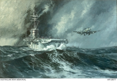
Mounted print of H.M.A.S.Sydney in Korean waters
... helicopter is hovering above the Sydney. HMAS Sydney joined United Nations forces in Korean waters in October 1951. The Sydneys' role consisted predominantly of direct attacks on ground targets and assistance to ground operations. ...The HMAS Sydney in Korean waters launching Hawker Sea Fury fighters. The HMAS Sydney is flanked on either sides by her destroyer escorts HMAS Tobruk, and HMCS Sioux. A rescue helicopter is hovering above the Sydney.HMAS Sydney joined United Nations forces in Korean waters in October 1951. The Sydneys' role consisted predominantly of direct attacks on ground targets and assistance to ground operations. Sydney can be seen here launching Hawker Sea Fury fighters from the Nos. 805 and 808 Squadrons with Fairey Firefly on deck.Mounted print of H.M.A.S.Sydney in Korean watersRay Honisett H.M.A.S.Sydney in Korean waters.1951_52 1975 oil on canvas 121.9 x 182.9cm Australian War Memorial (28077) Telegraphist E.LOGAN R.A.N. R51533 1957/58korean war, h.m.a.s.. sydney, navy, lara r.s.l. -
 Lara RSL Sub Branch
U.S. Iraqi Freedom Operations glass with pewter lid, Operation Iraqi Freedom, 2008
... On the top of this circle of emblems is a pair of crossed swords, on the blade of one the swords "Proud to serve" and the other sword "All gave some, some gave all" under the crossed swords is an inscription "Freedom and Justice for All" The center of this area is a pewter medallion labeled "Operation Iraqi Freedom" in the center of the medallion is map of Iraq with city centers mentioned and below is an eagle clutching a feather and sword. On the outside of this area is small pictures of: plane, helicopter...On the top of this circle of emblems is a pair of crossed swords, on the blade of one the swords "Proud to serve" and the other sword "All gave some, some gave all" under the crossed swords is an inscription "Freedom and Justice for All" The center of this area is a pewter medallion labeled "Operation Iraqi Freedom" in the center of the medallion is map of Iraq with city centers mentioned and below is an eagle clutching a feather and sword. On the outside of this area is small pictures of: plane, helicopter ...Commemorates operation Iraqi Freedom, U.S. forces involved in Iraqi and details losses incurred.Glass Mug Operation Iraqi Freedom with pewter lid contain Certificate of Authenticity U.S. Heritage Glass Series Number 2289 of 9000Certificate of Authenticity. US-Heritage Glass Series, The History of the U.S. Operation. Iraqi Freedom Column Crystal Glass with Pewter Lid.Pewter Lid is decorated with an inscription around the edge "Democracy, Freedom, Liberty, Honour, Courage. in the center is an eagle, two crossed U.S. Flags, A five pointed badge surrounded by a laurel wreath and in the center of the badge is a five pointed star. The thumb button has a congressional seal embossed there on.on the front of the glass is an area of gold leaf that has a heading "The History of the Liberation of Iraq" There are emblems of the U.S. armed forces that were involved in the conflict: U.S. Coast Guard, U.S. Marine Corp, U.S. Navy, Dept of Army, U.S. Air Force, Army National Guard, Air National Guard. On the top of this circle of emblems is a pair of crossed swords, on the blade of one the swords "Proud to serve" and the other sword "All gave some, some gave all" under the crossed swords is an inscription "Freedom and Justice for All" The center of this area is a pewter medallion labeled "Operation Iraqi Freedom" in the center of the medallion is map of Iraq with city centers mentioned and below is an eagle clutching a feather and sword. On the outside of this area is small pictures of: plane, helicopter, Parachute, jeep, soldier, large jet, aircraft carrier, oasis scene, truck, soldier, and tank. on the lower section is a representation of an American flag The bars contain details of the number and type of U.S. forces involved. The bottom is embossed with "God Bless the Defenders of Freedom and Democracy of Iraq"