Showing 1224 items matching "heritage site"
-
 Ballarat Heritage Services
Photograph - Colour, Avebury World Heritage Site, Prehistoric Monuments, England, 2017
... Avebury World Heritage Site, Prehistoric Monuments, England...avebury world heritage site...Colour photograph of Avebury World Heritage Site...Avebury World Heritage Site, England...Ballarat Heritage Services PO Box 2209 Bakery Hill Post Office goldfields avebury world heritage site rocks prehistoric monuments Colour photograph of Avebury World Heritage Site Avebury World Heritage Site, Prehistoric Monuments, England Photograph - Colour ...Colour photograph of Avebury World Heritage Siteavebury world heritage site, rocks, prehistoric monuments -
 Ballarat Heritage Services
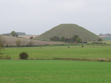
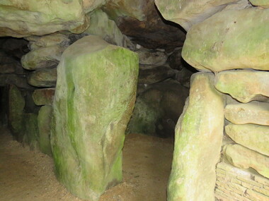
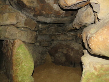
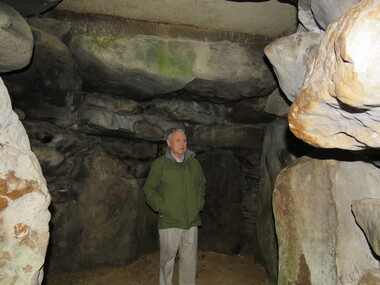
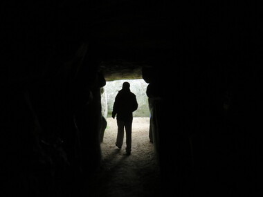
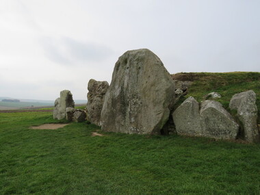
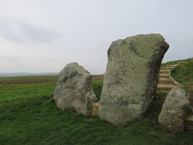
Photograph - Colour, Avebury World Heritage Site, Prehistoric Monuments, England, 2016
... Avebury World Heritage Site, Prehistoric Monuments, England...avebury world heritage site...Colour photograph of the Silbury Hill, an immense Neolithic man-made mound part of the Avebury World Heritage Site. The Avebury World Heritage Site is a complex of outstanding prehistoric monuments comprising Windmill Hill (Early Neolithic enclosure and Bronze Age burial mounds); Silbury Hill; West Kennet Long Barrow; Avebury Stone Circles and West Kennet Avenue; The Sanctuary (site of stone and timber circles). ...Avebury World Heritage Site, England...It is part of National Trust and English Heritage. Visitors may walk to sites. avebury world heritage site mound prehistoric monuments Silbury Hill West Kennet Long Barrow Neolithic world heritage Avebury World Heritage Site, Prehistoric Monuments, England Photograph - Colour ...Colour photograph of the Silbury Hill, an immense Neolithic man-made mound part of the Avebury World Heritage Site. The Avebury World Heritage Site is a complex of outstanding prehistoric monuments comprising Windmill Hill (Early Neolithic enclosure and Bronze Age burial mounds); Silbury Hill; West Kennet Long Barrow; Avebury Stone Circles and West Kennet Avenue; The Sanctuary (site of stone and timber circles). It is part of National Trust and English Heritage. Visitors may walk to sites.avebury world heritage site, mound, prehistoric monuments, silbury hill, west kennet long barrow, neolithic, world heritage -
 Ballarat Heritage Services
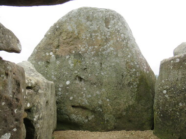
Photograph - Colour, Avebury World Heritage Site, Prehistoric Monuments, England, 2017
... Avebury World Heritage Site, Prehistoric Monuments, England...avebury world heritage site...Avebury World Heritage Site, England...Avebury World Heritage Site, Prehistoric Monuments, England Photograph - Colour ...Colour photograph of the Avebury Prehistoric Monument.avebury world heritage site, rocks, prehistoric monuments -
 Ballarat Heritage Services
Photograph - Colour, Silbury Hill, Avebury World Heritage Site, Prehistoric Monuments, England, 2016
... Silbury Hill, Avebury World Heritage Site, Prehistoric Monuments, England...avebury world heritage site...Colour photograph of the Silbury Hill, an immense Neolithic man-made mound part of the Avebury World Heritage Site. The Avebury World Heritage Site is a complex of outstanding prehistoric monuments comprising Windmill Hill (Early Neolithic enclosure and Bronze Age burial mounds); Silbury Hill; West Kennet Long Barrow; Avebury Stone Circles and West Kennet Avenue; The Sanctuary (site of stone and timber circles). ...Colour photograph of Avebury World Heritage Site. ...It is part of National Trust and English Heritage. Visitors may walk to sites. avebury world heritage site prehistoric monuments rocks Colour photograph of Avebury World Heritage Site. ...Colour photograph of the Silbury Hill, an immense Neolithic man-made mound part of the Avebury World Heritage Site. The Avebury World Heritage Site is a complex of outstanding prehistoric monuments comprising Windmill Hill (Early Neolithic enclosure and Bronze Age burial mounds); Silbury Hill; West Kennet Long Barrow; Avebury Stone Circles and West Kennet Avenue; The Sanctuary (site of stone and timber circles). It is part of National Trust and English Heritage. Visitors may walk to sites.Colour photograph of Avebury World Heritage Site. avebury world heritage site, prehistoric monuments, rocks -
 Ballarat Heritage Services
Photograph - Colour, Avebury World Heritage Site, Prehistoric Monuments, England, 2016
... Avebury World Heritage Site, Prehistoric Monuments, England...avebury world heritage site...Colour photograph of the Silbury Hill, an immense Neolithic man-made mound part of the Avebury World Heritage Site. The Avebury World Heritage Site is a complex of outstanding prehistoric monuments comprising Windmill Hill (Early Neolithic enclosure and Bronze Age burial mounds); Silbury Hill; West Kennet Long Barrow; Avebury Stone Circles and West Kennet Avenue; The Sanctuary (site of stone and timber circles). ...Colour photograph of Avebury World Heritage Site. ...It is part of National Trust and English Heritage. Visitors may walk to sites. avebury world heritage site prehistoric monuments rocks Colour photograph of Avebury World Heritage Site. ...Colour photograph of the Silbury Hill, an immense Neolithic man-made mound part of the Avebury World Heritage Site. The Avebury World Heritage Site is a complex of outstanding prehistoric monuments comprising Windmill Hill (Early Neolithic enclosure and Bronze Age burial mounds); Silbury Hill; West Kennet Long Barrow; Avebury Stone Circles and West Kennet Avenue; The Sanctuary (site of stone and timber circles). It is part of National Trust and English Heritage. Visitors may walk to sites.Colour photograph of Avebury World Heritage Site. avebury world heritage site, prehistoric monuments, rocks -
 Ballarat Heritage Services
Photograph - Colour, Avebury World Heritage Site, Prehistoric Monuments, England, 2016
... Avebury World Heritage Site, Prehistoric Monuments, England...avebury world heritage site...Colour photograph of the Silbury Hill, an immense Neolithic man-made mound part of the Avebury World Heritage Site. The Avebury World Heritage Site is a complex of outstanding prehistoric monuments comprising Windmill Hill (Early Neolithic enclosure and Bronze Age burial mounds); Silbury Hill; West Kennet Long Barrow; Avebury Stone Circles and West Kennet Avenue; The Sanctuary (site of stone and timber circles). ...Colour photograph of Avebury World Heritage Site....It is part of National Trust and English Heritage. Visitors may walk to sites. avebury world heritage site rocks prehistoric monuments Colour photograph of Avebury World Heritage Site. ...Colour photograph of the Silbury Hill, an immense Neolithic man-made mound part of the Avebury World Heritage Site. The Avebury World Heritage Site is a complex of outstanding prehistoric monuments comprising Windmill Hill (Early Neolithic enclosure and Bronze Age burial mounds); Silbury Hill; West Kennet Long Barrow; Avebury Stone Circles and West Kennet Avenue; The Sanctuary (site of stone and timber circles). It is part of National Trust and English Heritage. Visitors may walk to sites.Colour photograph of Avebury World Heritage Site.avebury world heritage site, rocks, prehistoric monuments -
 Ballarat Heritage Services
Photograph - Colour, Wayne Phillipson, Avebury World Heritage Site, Prehistoric Monuments, England, 2016
... Wayne Phillipson, Avebury World Heritage Site, Prehistoric Monuments, England......avebury world heritage site...Colour photograph of the Silbury Hill, an immense Neolithic man-made mound part of the Avebury World Heritage Site. The Avebury World Heritage Site is a complex of outstanding prehistoric monuments comprising Windmill Hill (Early Neolithic enclosure and Bronze Age burial mounds); Silbury Hill; West Kennet Long Barrow; Avebury Stone Circles and West Kennet Avenue; The Sanctuary (site of stone and timber circles). ...Colour photograph of the Avebury World Heritage Site....It is part of National Trust and English Heritage. Visitors may walk to sites. prehistoric monuments avebury world heritage site rocks Colour photograph of the Avebury World Heritage Site. ...Colour photograph of the Silbury Hill, an immense Neolithic man-made mound part of the Avebury World Heritage Site. The Avebury World Heritage Site is a complex of outstanding prehistoric monuments comprising Windmill Hill (Early Neolithic enclosure and Bronze Age burial mounds); Silbury Hill; West Kennet Long Barrow; Avebury Stone Circles and West Kennet Avenue; The Sanctuary (site of stone and timber circles). It is part of National Trust and English Heritage. Visitors may walk to sites.Colour photograph of the Avebury World Heritage Site.prehistoric monuments, avebury world heritage site, rocks -
 Ballarat Heritage Services
Photograph - Colour, Wayne Phillipson, Avebury World Heritage Site, Prehistoric Monuments, England, 2016
... Wayne Phillipson, Avebury World Heritage Site, Prehistoric Monuments, England...avebury world heritage site...Colour photograph of the Silbury Hill, an immense Neolithic man-made mound part of the Avebury World Heritage Site. The Avebury World Heritage Site is a complex of outstanding prehistoric monuments comprising Windmill Hill (Early Neolithic enclosure and Bronze Age burial mounds); Silbury Hill; West Kennet Long Barrow; Avebury Stone Circles and West Kennet Avenue; The Sanctuary (site of stone and timber circles). ...Colour photograph of Avebury World Heritage Site. ...It is part of National Trust and English Heritage. Visitors may walk to sites. avebury world heritage site prehistoric monuments rocks Colour photograph of Avebury World Heritage Site. ...Colour photograph of the Silbury Hill, an immense Neolithic man-made mound part of the Avebury World Heritage Site. The Avebury World Heritage Site is a complex of outstanding prehistoric monuments comprising Windmill Hill (Early Neolithic enclosure and Bronze Age burial mounds); Silbury Hill; West Kennet Long Barrow; Avebury Stone Circles and West Kennet Avenue; The Sanctuary (site of stone and timber circles). It is part of National Trust and English Heritage. Visitors may walk to sites.Colour photograph of Avebury World Heritage Site. avebury world heritage site, prehistoric monuments, rocks -
 Ballarat Heritage Services
Photograph - Colour, Silbury Hill, Avebury World Heritage Site, Prehistoric Monuments, England, 2016
... Silbury Hill, Avebury World Heritage Site, Prehistoric Monuments, England...avebury world heritage site...Colour photograph of the Silbury Hill, an immense Neolithic man-made mound part of the Avebury World Heritage Site. The Avebury World Heritage Site is a complex of outstanding prehistoric monuments comprising Windmill Hill (Early Neolithic enclosure and Bronze Age burial mounds); Silbury Hill; West Kennet Long Barrow; Avebury Stone Circles and West Kennet Avenue; The Sanctuary (site of stone and timber circles). ...Colour photograph of rocks at Avebury World Heritage Site ...It is part of National Trust and English Heritage. Visitors may walk to sites. avebury world heritage site prehistoric monuments rocks Colour photograph of rocks at Avebury World Heritage Site Silbury Hill, Avebury World Heritage Site, Prehistoric Monuments, England Photograph - Colour ...Colour photograph of the Silbury Hill, an immense Neolithic man-made mound part of the Avebury World Heritage Site. The Avebury World Heritage Site is a complex of outstanding prehistoric monuments comprising Windmill Hill (Early Neolithic enclosure and Bronze Age burial mounds); Silbury Hill; West Kennet Long Barrow; Avebury Stone Circles and West Kennet Avenue; The Sanctuary (site of stone and timber circles). It is part of National Trust and English Heritage. Visitors may walk to sites.Colour photograph of rocks at Avebury World Heritage Site avebury world heritage site, prehistoric monuments, rocks -
 Ballarat Heritage Services
Photograph - Colour, Avebury World Heritage Site, Prehistoric Monuments, England, 2017
... Avebury World Heritage Site, Prehistoric Monuments, England......Avebury World Heritage Site...Colour photograph of the Avenury World Heritage Site....Ballarat Heritage Services PO Box 2209 Bakery Hill Post Office goldfields prehistoric monuments Avebury World Heritage Site rocks Colour photograph of the Avenury World Heritage Site. ...Colour photograph of the Avenury World Heritage Site.prehistoric monuments, avebury world heritage site, rocks -
 Ballarat Heritage Services
Photograph - Colour, Avebury World Heritage Site, Prehistoric Monuments, England, 2016
... Avebury World Heritage Site, Prehistoric Monuments, England...avebury world heritage site...Colour photograph of the Silbury Hill, an immense Neolithic man-made mound part of the Avebury World Heritage Site. The Avebury World Heritage Site is a complex of outstanding prehistoric monuments comprising Windmill Hill (Early Neolithic enclosure and Bronze Age burial mounds); Silbury Hill; West Kennet Long Barrow; Avebury Stone Circles and West Kennet Avenue; The Sanctuary (site of stone and timber circles). ...Avebury World Heritage Site, Prehistoric Monuments, England Photograph - Colour ...Colour photograph of the Silbury Hill, an immense Neolithic man-made mound part of the Avebury World Heritage Site. The Avebury World Heritage Site is a complex of outstanding prehistoric monuments comprising Windmill Hill (Early Neolithic enclosure and Bronze Age burial mounds); Silbury Hill; West Kennet Long Barrow; Avebury Stone Circles and West Kennet Avenue; The Sanctuary (site of stone and timber circles). It is part of National Trust and English Heritage. Visitors may walk to sites.Colour photograph of Avebury World Heritage Stte.avebury world heritage site, prehistoric monuments, rocks -
 Ballarat Heritage Services
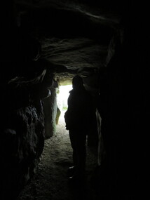
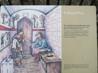
Photograph - Colour, Sign Explaining toilets, Old Sarum, England, English Heritage Site, 01/11/2016
... Sign Explaining toilets, Old Sarum, England, English Heritage Site...Colour photograph of a sign explaining toilets at Old Sarum, English Heritage Site...The nearer end of Mudge's line is marked by an inscribed stone beside the modern A345 at Old Sarum. ordnance survey william mudge jesse ramsden william the conqueror old sarum saxon 1086, england Colour photograph of a sign explaining toilets at Old Sarum, English Heritage Site Sign Explaining toilets, Old Sarum, England, English Heritage Site Photograph - Colour ...William the Conqueror inherited Old Sarum from the last Saxon king of England. It was an ideal site for a royal castle. It was here in 1070 that William paid off his army after a long and bitter campaign in northern England. It was here in 1086 that he called together all the major landholders in England so they could swear allegiance to him. It was a crucial moment. The Domesday Book was being written, a threatened Viking invasion had only just been averted and William's eldest son was in armed rebellion. Old Sarum was an important place where this Norman king of England held power. In 1794 the Ordnance Survey set out to check the accuracy of the first mapping of Southern England, which had begun ten years earlier. From a point just below Old Sarum Lieutenant William Mudge laid out a base-line 36,574 feet (11,253 metres) long. From each end of the line the positions of distant places were plotted using a huge theodolite made in 1791 by Jesse Ramsden. The accuracy of the process, which was repeated all over England, depended on Jesse Ramsden's craftsmanship and on William Mudge's surveying skill in setting out this first base-line from Old Sarum. The nearer end of Mudge's line is marked by an inscribed stone beside the modern A345 at Old Sarum. Colour photograph of a sign explaining toilets at Old Sarum, English Heritage Siteordnance survey, william mudge, jesse ramsden, william the conqueror, old sarum, saxon, 1086,, england -
 Buninyong & District Historical Society
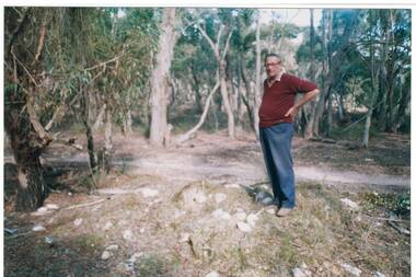
Photograph - Chinese graves, Misery Creek, Enfield, Chinese heritage site
... Chinese heritage site...Buninyong & District Historical Society Old Court House, Buninyong Town Hall 313 Learmonth Street Buninyong goldfields Local history and evidence of Chinese heritage Local history of Chinese mining Chinese grave sites Evidence of Chinese mining activity in area Local mining history None Good condition with no blemishes or marks Chinese heritage site Photograph Chinese graves, Misery Creek, Enfield ...Local history and evidence of Chinese heritageLocal history of Chinese miningGood condition with no blemishes or marksNonechinese grave sites, evidence of chinese mining activity in area, local mining history -
 Whitehorse Historical Society Inc.
Document, Visit our treasured heritage site!, 2007
... Visit our treasured heritage site!...Visit our treasured heritage site! Document Document ...Advertisement for Heritage Day at Schwerkolt Cottage & Museum Complex on 9 September 2007.Advertisement for Heritage Day at Schwerkolt Cottage & Museum Complex on 9 September 2007.Advertisement for Heritage Day at Schwerkolt Cottage & Museum Complex on 9 September 2007.schwerkolt cottage & museum complex, heritage festivals, city of whitehorse, whitehorse historical society inc -
 Ballarat Heritage Services
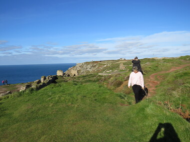
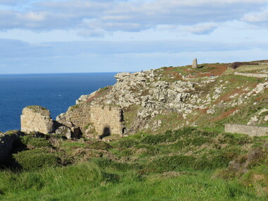
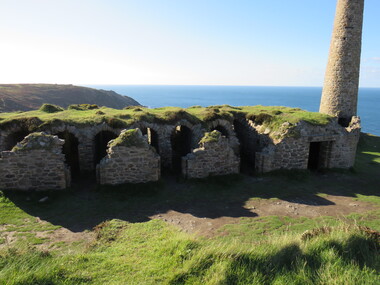
Photograph - Colour, Dorothy Wickham, St Just, Cronwall, World Heritage Site
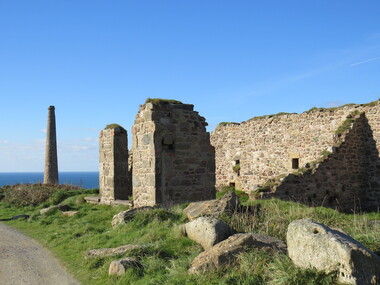
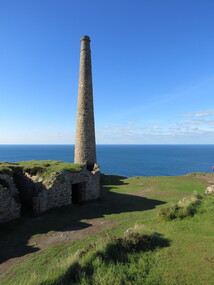
... St Just, Cronwall, World Heritage Site...site open to the public in the UK. The historic mining town of St Just is home to characteristic rows of granite mine workers’ cottages, public squares, shops, cafés, art galleries and, just off Bank Square, a medieval grassed amphitheatre – the Plen an Gwary or ‘playing place’. st just, world heritage, ellis, penrose, cornwall, mining, mines St Just, Cronwall, World Heritage Site Photograph - Colour Dorothy Wickham ...A stone’s throw from Land’s End, this is the most westerly Area of the Site. St Just is characterised by big skies, jagged rocks, stark moorland, and iconic clifftop engine houses perched above the Atlantic in some incredible locations. No wonder this dramatic setting has inspired generations of artists, writers and photographers. World-famous for their mineralogy, the mining sites here are extremely well preserved – as is the sense of community amongst the people whose lives they once dominated. This Area’s unique geography and mineralogy meant that undersea mining was more concentrated here than anywhere else in the world in the 18th and 19th centuries. The oldest surviving Cornish beam engine (constructed in 1840) remains in its original engine house at Levant, restored and still working under steam. Geevor, one of the last mines to close in Cornwall (1990), was saved from demolition and is now the largest metalliferous mine site open to the public in the UK. The historic mining town of St Just is home to characteristic rows of granite mine workers’ cottages, public squares, shops, cafés, art galleries and, just off Bank Square, a medieval grassed amphitheatre – the Plen an Gwary or ‘playing place’.st just, world heritage, ellis, penrose, cornwall, mining, mines -
 Ballarat Heritage Services
Photograph - Colour, Dorothy Wickham, St Just, Cornwall, World Heritage Site
... St Just, Cornwall, World Heritage Site...site open to the public in the UK. The historic mining town of St Just is home to characteristic rows of granite mine workers’ cottages, public squares, shops, cafés, art galleries and, just off Bank Square, a medieval grassed amphitheatre – the Plen an Gwary or ‘playing place’. st just world heritage, ellis, penrose cornwall mining mines St Just, Cornwall, World Heritage Site Photograph - Colour Dorothy Wickham ...A stone’s throw from Land’s End, this is the most westerly Area of the Site. St Just is characterised by big skies, jagged rocks, stark moorland, and iconic clifftop engine houses perched above the Atlantic in some incredible locations. No wonder this dramatic setting has inspired generations of artists, writers and photographers. World-famous for their mineralogy, the mining sites here are extremely well preserved – as is the sense of community amongst the people whose lives they once dominated. This Area’s unique geography and mineralogy meant that undersea mining was more concentrated here than anywhere else in the world in the 18th and 19th centuries. The oldest surviving Cornish beam engine (constructed in 1840) remains in its original engine house at Levant, restored and still working under steam. Geevor, one of the last mines to close in Cornwall (1990), was saved from demolition and is now the largest metalliferous mine site open to the public in the UK. The historic mining town of St Just is home to characteristic rows of granite mine workers’ cottages, public squares, shops, cafés, art galleries and, just off Bank Square, a medieval grassed amphitheatre – the Plen an Gwary or ‘playing place’.st just, world heritage,, ellis,, penrose, cornwall, mining, mines -
 Ballarat Heritage Services
Photograph - Colour, Dorothy Wickham, St Just, Cornwall, World Heritage Site
... St Just, Cornwall, World Heritage Site...site open to the public in the UK. The historic mining town of St Just is home to characteristic rows of granite mine workers’ cottages, public squares, shops, cafés, art galleries and, just off Bank Square, a medieval grassed amphitheatre – the Plen an Gwary or ‘playing place’. st just, world heritage, ellis, penrose, cornwall, mining, mines St Just, Cornwall, World Heritage Site Photograph - Colour Dorothy Wickham ...A stone’s throw from Land’s End, this is the most westerly Area of the Site. St Just is characterised by big skies, jagged rocks, stark moorland, and iconic clifftop engine houses perched above the Atlantic in some incredible locations. No wonder this dramatic setting has inspired generations of artists, writers and photographers. World-famous for their mineralogy, the mining sites here are extremely well preserved – as is the sense of community amongst the people whose lives they once dominated. This Area’s unique geography and mineralogy meant that undersea mining was more concentrated here than anywhere else in the world in the 18th and 19th centuries. The oldest surviving Cornish beam engine (constructed in 1840) remains in its original engine house at Levant, restored and still working under steam. Geevor, one of the last mines to close in Cornwall (1990), was saved from demolition and is now the largest metalliferous mine site open to the public in the UK. The historic mining town of St Just is home to characteristic rows of granite mine workers’ cottages, public squares, shops, cafés, art galleries and, just off Bank Square, a medieval grassed amphitheatre – the Plen an Gwary or ‘playing place’.st just, world heritage, ellis, penrose, cornwall, mining, mines -
 Ballarat Heritage Services
Photograph - Colour, Dorothy Wickham, St Just, Cronwall, World Heritage Site
... St Just, Cronwall, World Heritage Site...site open to the public in the UK. The historic mining town of St Just is home to characteristic rows of granite mine workers’ cottages, public squares, shops, cafés, art galleries and, just off Bank Square, a medieval grassed amphitheatre – the Plen an Gwary or ‘playing place’. st just, world heritage, ellis, penrose, cornwall, mining, mines St Just, Cronwall, World Heritage Site Photograph - Colour Dorothy Wickham ...A stone’s throw from Land’s End, this is the most westerly Area of the Site. St Just is characterised by big skies, jagged rocks, stark moorland, and iconic clifftop engine houses perched above the Atlantic in some incredible locations. No wonder this dramatic setting has inspired generations of artists, writers and photographers. World-famous for their mineralogy, the mining sites here are extremely well preserved – as is the sense of community amongst the people whose lives they once dominated. This Area’s unique geography and mineralogy meant that undersea mining was more concentrated here than anywhere else in the world in the 18th and 19th centuries. The oldest surviving Cornish beam engine (constructed in 1840) remains in its original engine house at Levant, restored and still working under steam. Geevor, one of the last mines to close in Cornwall (1990), was saved from demolition and is now the largest metalliferous mine site open to the public in the UK. The historic mining town of St Just is home to characteristic rows of granite mine workers’ cottages, public squares, shops, cafés, art galleries and, just off Bank Square, a medieval grassed amphitheatre – the Plen an Gwary or ‘playing place’.st just, world heritage, ellis, penrose, cornwall, mining, mines -
 Ballarat Heritage Services
Photograph - Colour, Dorothy Wickham, St Just, Cornwall, World Heritage Site
... St Just, Cornwall, World Heritage Site...site open to the public in the UK. The historic mining town of St Just is home to characteristic rows of granite mine workers’ cottages, public squares, shops, cafés, art galleries and, just off Bank Square, a medieval grassed amphitheatre – the Plen an Gwary or ‘playing place’. st just, world heritage, ellis, penrose, cornwall, mining, mines St Just, Cornwall, World Heritage Site Photograph - Colour Dorothy Wickham ...A stone’s throw from Land’s End, this is the most westerly Area of the Site. St Just is characterised by big skies, jagged rocks, stark moorland, and iconic clifftop engine houses perched above the Atlantic in some incredible locations. No wonder this dramatic setting has inspired generations of artists, writers and photographers. World-famous for their mineralogy, the mining sites here are extremely well preserved – as is the sense of community amongst the people whose lives they once dominated. This Area’s unique geography and mineralogy meant that undersea mining was more concentrated here than anywhere else in the world in the 18th and 19th centuries. The oldest surviving Cornish beam engine (constructed in 1840) remains in its original engine house at Levant, restored and still working under steam. Geevor, one of the last mines to close in Cornwall (1990), was saved from demolition and is now the largest metalliferous mine site open to the public in the UK. The historic mining town of St Just is home to characteristic rows of granite mine workers’ cottages, public squares, shops, cafés, art galleries and, just off Bank Square, a medieval grassed amphitheatre – the Plen an Gwary or ‘playing place’.st just, world heritage, ellis, penrose, cornwall, mining, mines -
 Ballarat Heritage Services
Photograph - Colour, Dorothy Wickham, St Just, Cornwall, World Heritage Site
... St Just, Cornwall, World Heritage Site...site open to the public in the UK. The historic mining town of St Just is home to characteristic rows of granite mine workers’ cottages, public squares, shops, cafés, art galleries and, just off Bank Square, a medieval grassed amphitheatre – the Plen an Gwary or ‘playing place’. st just, world heritage, ellis, penrose, cornwall, mining, mines St Just, Cornwall, World Heritage Site Photograph - Colour Dorothy Wickham ...A stone’s throw from Land’s End, this is the most westerly Area of the Site. St Just is characterised by big skies, jagged rocks, stark moorland, and iconic clifftop engine houses perched above the Atlantic in some incredible locations. No wonder this dramatic setting has inspired generations of artists, writers and photographers. World-famous for their mineralogy, the mining sites here are extremely well preserved – as is the sense of community amongst the people whose lives they once dominated. This Area’s unique geography and mineralogy meant that undersea mining was more concentrated here than anywhere else in the world in the 18th and 19th centuries. The oldest surviving Cornish beam engine (constructed in 1840) remains in its original engine house at Levant, restored and still working under steam. Geevor, one of the last mines to close in Cornwall (1990), was saved from demolition and is now the largest metalliferous mine site open to the public in the UK. The historic mining town of St Just is home to characteristic rows of granite mine workers’ cottages, public squares, shops, cafés, art galleries and, just off Bank Square, a medieval grassed amphitheatre – the Plen an Gwary or ‘playing place’.st just, world heritage, ellis, penrose, cornwall, mining, mines -
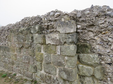
 Ballarat Heritage Services
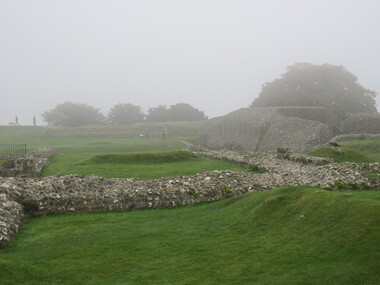
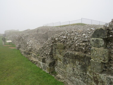
Photograph - Colour, looking from Stonework towards earth mounds, Old Sarum, England, English Heritage Site, 2016, 01 November 2016
... looking from Stonework towards earth mounds, Old Sarum, England, English Heritage Site, 2016...The nearer end of Mudge's line is marked by an inscribed stone beside the modern A345 at Old Sarum. ordnance survey, william mudge, jesse ramsden, william the conqueror, old sarum, saxon, 1086, england looking from Stonework towards earth mounds, Old Sarum, England, English Heritage Site, 2016 Photograph - Colour ...William the Conqueror inherited Old Sarum from the last Saxon king of England. It was an ideal site for a royal castle. It was here in 1070 that William paid off his army after a long and bitter campaign in northern England. It was here in 1086 that he called together all the major landholders in England so they could swear allegiance to him. It was a crucial moment. The Domesday Book was being written, a threatened Viking invasion had only just been averted and William's eldest son was in armed rebellion. Old Sarum was an important place where this Norman king of England held power. In 1794 the Ordnance Survey set out to check the accuracy of the first mapping of Southern England, which had begun ten years earlier. From a point just below Old Sarum Lieutenant William Mudge laid out a base-line 36,574 feet (11,253 metres) long. From each end of the line the positions of distant places were plotted using a huge theodolite made in 1791 by Jesse Ramsden. The accuracy of the process, which was repeated all over England, depended on Jesse Ramsden's craftsmanship and on William Mudge's surveying skill in setting out this first base-line from Old Sarum. The nearer end of Mudge's line is marked by an inscribed stone beside the modern A345 at Old Sarum. ordnance survey, william mudge, jesse ramsden, william the conqueror, old sarum, saxon, 1086, england -
 Ballarat Heritage Services
Photograph - Colour, Looking from Stonework towards people walking on earth mounds, Old Sarum, England, English Heritage Site, 2016, 01 November 2016
... Looking from Stonework towards people walking on earth mounds, Old Sarum, England, English Heritage Site, 2016...The nearer end of Mudge's line is marked by an inscribed stone beside the modern A345 at Old Sarum. ordnance survey, william mudge, jesse ramsden, william the conqueror, old sarum, saxon, 1086, england Looking from Stonework towards people walking on earth mounds, Old Sarum, England, English Heritage Site, 2016 Photograph - Colour ...William the Conqueror inherited Old Sarum from the last Saxon king of England. It was an ideal site for a royal castle. It was here in 1070 that William paid off his army after a long and bitter campaign in northern England. It was here in 1086 that he called together all the major landholders in England so they could swear allegiance to him. It was a crucial moment. The Domesday Book was being written, a threatened Viking invasion had only just been averted and William's eldest son was in armed rebellion. Old Sarum was an important place where this Norman king of England held power. In 1794 the Ordnance Survey set out to check the accuracy of the first mapping of Southern England, which had begun ten years earlier. From a point just below Old Sarum Lieutenant William Mudge laid out a base-line 36,574 feet (11,253 metres) long. From each end of the line the positions of distant places were plotted using a huge theodolite made in 1791 by Jesse Ramsden. The accuracy of the process, which was repeated all over England, depended on Jesse Ramsden's craftsmanship and on William Mudge's surveying skill in setting out this first base-line from Old Sarum. The nearer end of Mudge's line is marked by an inscribed stone beside the modern A345 at Old Sarum. ordnance survey, william mudge, jesse ramsden, william the conqueror, old sarum, saxon, 1086, england -
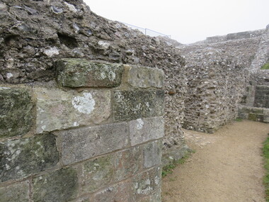
 Ballarat Heritage Services
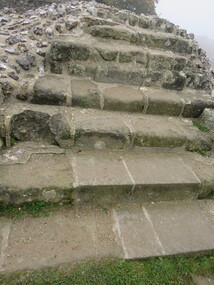
Photograph - Colour, Stairs, Old Sarum, England, English Heritage Site, 2016, 01 November 2016
... Stairs, Old Sarum, England, English Heritage Site, 2016...The nearer end of Mudge's line is marked by an inscribed stone beside the modern A345 at Old Sarum. ordnance survey, william mudge, jesse ramsden, william the conqueror, old sarum, saxon, 1086, england Stairs, Old Sarum, England, English Heritage Site, 2016 Photograph - Colour ...William the Conqueror inherited Old Sarum from the last Saxon king of England. It was an ideal site for a royal castle. It was here in 1070 that William paid off his army after a long and bitter campaign in northern England. It was here in 1086 that he called together all the major landholders in England so they could swear allegiance to him. It was a crucial moment. The Domesday Book was being written, a threatened Viking invasion had only just been averted and William's eldest son was in armed rebellion. Old Sarum was an important place where this Norman king of England held power. In 1794 the Ordnance Survey set out to check the accuracy of the first mapping of Southern England, which had begun ten years earlier. From a point just below Old Sarum Lieutenant William Mudge laid out a base-line 36,574 feet (11,253 metres) long. From each end of the line the positions of distant places were plotted using a huge theodolite made in 1791 by Jesse Ramsden. The accuracy of the process, which was repeated all over England, depended on Jesse Ramsden's craftsmanship and on William Mudge's surveying skill in setting out this first base-line from Old Sarum. The nearer end of Mudge's line is marked by an inscribed stone beside the modern A345 at Old Sarum. ordnance survey, william mudge, jesse ramsden, william the conqueror, old sarum, saxon, 1086, england -
 Ballarat Heritage Services
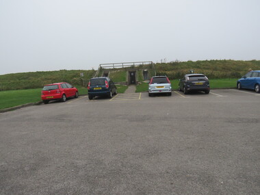
Photograph - Colour, Public toilets hidden in earth mound, Old Sarum, England, English Heritage Site, 2016, 01 November 2016
... Public toilets hidden in earth mound, Old Sarum, England, English Heritage Site, 2016...The nearer end of Mudge's line is marked by an inscribed stone beside the modern A345 at Old Sarum. ordnance survey, william mudge, jesse ramsden, william the conqueror, old sarum, saxon, 1086, england Public toilets hidden in earth mound, Old Sarum, England, English Heritage Site, 2016 Photograph - Colour ...William the Conqueror inherited Old Sarum from the last Saxon king of England. It was an ideal site for a royal castle. It was here in 1070 that William paid off his army after a long and bitter campaign in northern England. It was here in 1086 that he called together all the major landholders in England so they could swear allegiance to him. It was a crucial moment. The Domesday Book was being written, a threatened Viking invasion had only just been averted and William's eldest son was in armed rebellion. Old Sarum was an important place where this Norman king of England held power. In 1794 the Ordnance Survey set out to check the accuracy of the first mapping of Southern England, which had begun ten years earlier. From a point just below Old Sarum Lieutenant William Mudge laid out a base-line 36,574 feet (11,253 metres) long. From each end of the line the positions of distant places were plotted using a huge theodolite made in 1791 by Jesse Ramsden. The accuracy of the process, which was repeated all over England, depended on Jesse Ramsden's craftsmanship and on William Mudge's surveying skill in setting out this first base-line from Old Sarum. The nearer end of Mudge's line is marked by an inscribed stone beside the modern A345 at Old Sarum. ordnance survey, william mudge, jesse ramsden, william the conqueror, old sarum, saxon, 1086, england -
 Ballarat Heritage Services
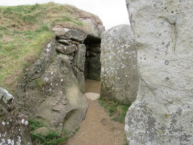
Photograph - Colour, Entrance to Public toilets hidden in earth mound, Old Sarum, England, English Heritage Site, 2016, 01 November 2016
... Entrance to Public toilets hidden in earth mound, Old Sarum, England, English Heritage Site, 2016...The nearer end of Mudge's line is marked by an inscribed stone beside the modern A345 at Old Sarum. ordnance survey, william mudge, jesse ramsden, william the conqueror, old sarum, saxon, 1086, england Entrance to Public toilets hidden in earth mound, Old Sarum, England, English Heritage Site, 2016 Photograph - Colour ...William the Conqueror inherited Old Sarum from the last Saxon king of England. It was an ideal site for a royal castle. It was here in 1070 that William paid off his army after a long and bitter campaign in northern England. It was here in 1086 that he called together all the major landholders in England so they could swear allegiance to him. It was a crucial moment. The Domesday Book was being written, a threatened Viking invasion had only just been averted and William's eldest son was in armed rebellion. Old Sarum was an important place where this Norman king of England held power. In 1794 the Ordnance Survey set out to check the accuracy of the first mapping of Southern England, which had begun ten years earlier. From a point just below Old Sarum Lieutenant William Mudge laid out a base-line 36,574 feet (11,253 metres) long. From each end of the line the positions of distant places were plotted using a huge theodolite made in 1791 by Jesse Ramsden. The accuracy of the process, which was repeated all over England, depended on Jesse Ramsden's craftsmanship and on William Mudge's surveying skill in setting out this first base-line from Old Sarum. The nearer end of Mudge's line is marked by an inscribed stone beside the modern A345 at Old Sarum. ordnance survey, william mudge, jesse ramsden, william the conqueror, old sarum, saxon, 1086, england -
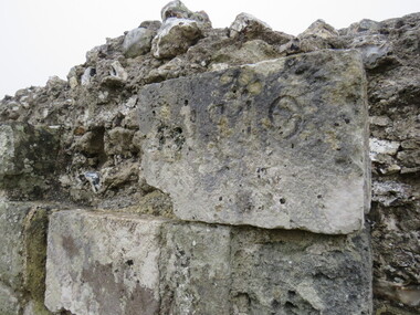
 Ballarat Heritage Services
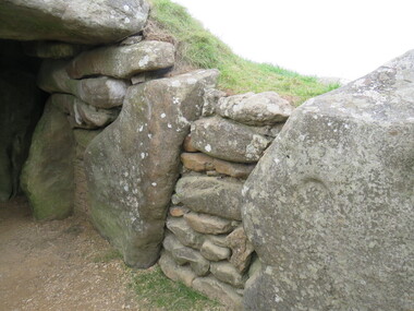
Photograph - Colour, Masons' Marks, Old Sarum, England, English Heritage Site, 2016, 01 November 2016
... Masons' Marks, Old Sarum, England, English Heritage Site, 2016...The nearer end of Mudge's line is marked by an inscribed stone beside the modern A345 at Old Sarum. ordnance survey, william mudge, jesse ramsden, william the conqueror, old sarum, saxon, 1086, england Masons' Marks, Old Sarum, England, English Heritage Site, 2016 Photograph - Colour ...William the Conqueror inherited Old Sarum from the last Saxon king of England. It was an ideal site for a royal castle. It was here in 1070 that William paid off his army after a long and bitter campaign in northern England. It was here in 1086 that he called together all the major landholders in England so they could swear allegiance to him. It was a crucial moment. The Domesday Book was being written, a threatened Viking invasion had only just been averted and William's eldest son was in armed rebellion. Old Sarum was an important place where this Norman king of England held power. In 1794 the Ordnance Survey set out to check the accuracy of the first mapping of Southern England, which had begun ten years earlier. From a point just below Old Sarum Lieutenant William Mudge laid out a base-line 36,574 feet (11,253 metres) long. From each end of the line the positions of distant places were plotted using a huge theodolite made in 1791 by Jesse Ramsden. The accuracy of the process, which was repeated all over England, depended on Jesse Ramsden's craftsmanship and on William Mudge's surveying skill in setting out this first base-line from Old Sarum. The nearer end of Mudge's line is marked by an inscribed stone beside the modern A345 at Old Sarum. ordnance survey, william mudge, jesse ramsden, william the conqueror, old sarum, saxon, 1086, england -
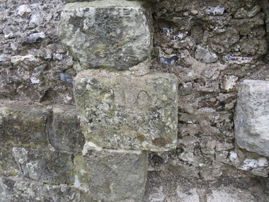
 Ballarat Heritage Services
Photograph - Colour, Masons' Marks, Old Sarum, England, English Heritage Site, 2016, 01 November 2016
... Masons' Marks, Old Sarum, England, English Heritage Site, 2016...The nearer end of Mudge's line is marked by an inscribed stone beside the modern A345 at Old Sarum. ordnance survey, william mudge, jesse ramsden, william the conqueror, old sarum, saxon, 1086, england Masons' Marks, Old Sarum, England, English Heritage Site, 2016 Photograph - Colour ...William the Conqueror inherited Old Sarum from the last Saxon king of England. It was an ideal site for a royal castle. It was here in 1070 that William paid off his army after a long and bitter campaign in northern England. It was here in 1086 that he called together all the major landholders in England so they could swear allegiance to him. It was a crucial moment. The Domesday Book was being written, a threatened Viking invasion had only just been averted and William's eldest son was in armed rebellion. Old Sarum was an important place where this Norman king of England held power. In 1794 the Ordnance Survey set out to check the accuracy of the first mapping of Southern England, which had begun ten years earlier. From a point just below Old Sarum Lieutenant William Mudge laid out a base-line 36,574 feet (11,253 metres) long. From each end of the line the positions of distant places were plotted using a huge theodolite made in 1791 by Jesse Ramsden. The accuracy of the process, which was repeated all over England, depended on Jesse Ramsden's craftsmanship and on William Mudge's surveying skill in setting out this first base-line from Old Sarum. The nearer end of Mudge's line is marked by an inscribed stone beside the modern A345 at Old Sarum. ordnance survey, william mudge, jesse ramsden, william the conqueror, old sarum, saxon, 1086, england -
 Ballarat Heritage Services
Photograph - Colour, Masons' Marks, Old Sarum, England, English Heritage Site, 01 November 2016
... Masons' Marks, Old Sarum, England, English Heritage Site...The nearer end of Mudge's line is marked by an inscribed stone beside the modern A345 at Old Sarum. ordnance survey, william mudge, jesse ramsden, william the conqueror, old sarum, saxon, 1086, england Masons' Marks, Old Sarum, England, English Heritage Site Photograph - Colour ...William the Conqueror inherited Old Sarum from the last Saxon king of England. It was an ideal site for a royal castle. It was here in 1070 that William paid off his army after a long and bitter campaign in northern England. It was here in 1086 that he called together all the major landholders in England so they could swear allegiance to him. It was a crucial moment. The Domesday Book was being written, a threatened Viking invasion had only just been averted and William's eldest son was in armed rebellion. Old Sarum was an important place where this Norman king of England held power. In 1794 the Ordnance Survey set out to check the accuracy of the first mapping of Southern England, which had begun ten years earlier. From a point just below Old Sarum Lieutenant William Mudge laid out a base-line 36,574 feet (11,253 metres) long. From each end of the line the positions of distant places were plotted using a huge theodolite made in 1791 by Jesse Ramsden. The accuracy of the process, which was repeated all over England, depended on Jesse Ramsden's craftsmanship and on William Mudge's surveying skill in setting out this first base-line from Old Sarum. The nearer end of Mudge's line is marked by an inscribed stone beside the modern A345 at Old Sarum. ordnance survey, william mudge, jesse ramsden, william the conqueror, old sarum, saxon, 1086, england -
 Ballarat Heritage Services
Photograph - Colour, Masons' Marks, Old Sarum, England, English Heritage Site, 2016, 01 November 2016
... Masons' Marks, Old Sarum, England, English Heritage Site, 2016...The nearer end of Mudge's line is marked by an inscribed stone beside the modern A345 at Old Sarum. ordnance survey, william mudge, jesse ramsden, william the conqueror, old sarum, saxon, 1086, england Masons' Marks, Old Sarum, England, English Heritage Site, 2016 Photograph - Colour ...William the Conqueror inherited Old Sarum from the last Saxon king of England. It was an ideal site for a royal castle. It was here in 1070 that William paid off his army after a long and bitter campaign in northern England. It was here in 1086 that he called together all the major landholders in England so they could swear allegiance to him. It was a crucial moment. The Domesday Book was being written, a threatened Viking invasion had only just been averted and William's eldest son was in armed rebellion. Old Sarum was an important place where this Norman king of England held power. In 1794 the Ordnance Survey set out to check the accuracy of the first mapping of Southern England, which had begun ten years earlier. From a point just below Old Sarum Lieutenant William Mudge laid out a base-line 36,574 feet (11,253 metres) long. From each end of the line the positions of distant places were plotted using a huge theodolite made in 1791 by Jesse Ramsden. The accuracy of the process, which was repeated all over England, depended on Jesse Ramsden's craftsmanship and on William Mudge's surveying skill in setting out this first base-line from Old Sarum. The nearer end of Mudge's line is marked by an inscribed stone beside the modern A345 at Old Sarum. ordnance survey, william mudge, jesse ramsden, william the conqueror, old sarum, saxon, 1086, england -
 Ballarat Heritage Services
Photograph - Colour, Masons' Marks, Old Sarum, England, English Heritage Site, 2016, 01 November 2016
... Masons' Marks, Old Sarum, England, English Heritage Site, 2016...The nearer end of Mudge's line is marked by an inscribed stone beside the modern A345 at Old Sarum. ordnance survey, william mudge, jesse ramsden, william the conqueror, old sarum, saxon, 1086, england Masons' Marks, Old Sarum, England, English Heritage Site, 2016 Photograph - Colour ...William the Conqueror inherited Old Sarum from the last Saxon king of England. It was an ideal site for a royal castle. It was here in 1070 that William paid off his army after a long and bitter campaign in northern England. It was here in 1086 that he called together all the major landholders in England so they could swear allegiance to him. It was a crucial moment. The Domesday Book was being written, a threatened Viking invasion had only just been averted and William's eldest son was in armed rebellion. Old Sarum was an important place where this Norman king of England held power. In 1794 the Ordnance Survey set out to check the accuracy of the first mapping of Southern England, which had begun ten years earlier. From a point just below Old Sarum Lieutenant William Mudge laid out a base-line 36,574 feet (11,253 metres) long. From each end of the line the positions of distant places were plotted using a huge theodolite made in 1791 by Jesse Ramsden. The accuracy of the process, which was repeated all over England, depended on Jesse Ramsden's craftsmanship and on William Mudge's surveying skill in setting out this first base-line from Old Sarum. The nearer end of Mudge's line is marked by an inscribed stone beside the modern A345 at Old Sarum. ordnance survey, william mudge, jesse ramsden, william the conqueror, old sarum, saxon, 1086, england