Showing 320 items matching "heritage survey"
-
 Whitehorse Historical Society Inc.
Document, Heritage survey, 1/10/1994 12:00:00 AM
... Heritage survey...City of Nunawading Heritage Survey Project [Description]. Context Pty Ltd [Consultants] October 1994. ...(Original and 2 photocopies) Heritage survey Document Document ...City of Nunawading Heritage Survey Project [Description]. Context Pty Ltd [Consultants] October 1994.City of Nunawading Heritage Survey Project [Description]. Context Pty Ltd [Consultants] October 1994. (Original and 2 photocopies)City of Nunawading Heritage Survey Project [Description]. Context Pty Ltd [Consultants] October 1994. city of nunawading, historic buildings, context pty ltd -
Whitehorse Historical Society Inc.
Document, City of Nunawading Heritage Survey Project, 1/10/1994 12:00:00 AM
... City of Nunawading Heritage Survey Project...City of Nunawading Heritage Survey...City of Nunawading Heritage Survey Project Document Document ...Database of places recognised in the field survey.Database of places recognised in the field survey. List of buildings, roads etc with indexes by value and by street name.Database of places recognised in the field survey. city of nunawading heritage survey, street name -
Whitehorse Historical Society Inc.
Document, List of significant sites in Nunawading, c1994
... City of Nunawading Heritage Survey...Non annotated list - probably prepared in preparation for the City of Nunawading Heritage Survey Project....Whitehorse Historical Society Inc. 2-10 Deep Creek Road Mitcham melbourne City of Nunawading Heritage Survey Arrowsmith Valda Non annotated list - probably prepared in preparation for the City of Nunawading Heritage Survey Project. ...Non annotated list - probably prepared in preparation for the City of Nunawading Heritage Survey Project.Non annotated list - probably prepared in preparation for the City of Nunawading Heritage Survey Project.Non annotated list - probably prepared in preparation for the City of Nunawading Heritage Survey Project.city of nunawading heritage survey, arrowsmith, valda -
 Emerald Museum & Nobelius Heritage Park
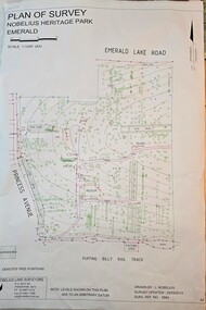
Map - Plan of Survey - Nobelius Heritage Park 2013, L. Nobelius, Nobelius Heritage Park, Plan of Survey 2013, c2013
... Plan of Survey - Nobelius Heritage Park 2013...Nobelius Heritage Park, Plan of Survey 2013...Image of Plan of Survey of Nobelius Heritage Park, Emerald...Topographical map of Nobelius Heritage Park/Denotes tree positions/Scale 1:1000 (A3)/drawn by L.NOBELIUS 20/3/2013/Survey Ref Number 5884/Nobelius Land Surveyors, PO Box 461, Pakenham 3810, Ph 03 9541 4112...Nobelius Historical connection between surveyor and the park's creator Topographical map of Nobelius Heritage Park/Denotes tree positions/Scale 1:1000 (A3)/drawn by L.NOBELIUS 20/3/2013/Survey Ref Number 5884/Nobelius Land Surveyors, PO Box 461, Pakenham 3810, Ph 03 9541 4112 Image of Plan of Survey of Nobelius Heritage Park, Emerald Nobelius Heritage Park, Plan of Survey 2013 Map Plan of Survey - Nobelius Heritage Park 2013 L. ...Survey map printed by L. NobeliusHistorical connection between surveyor and the park's creatorImage of Plan of Survey of Nobelius Heritage Park, EmeraldTopographical map of Nobelius Heritage Park/Denotes tree positions/Scale 1:1000 (A3)/drawn by L.NOBELIUS 20/3/2013/Survey Ref Number 5884/Nobelius Land Surveyors, PO Box 461, Pakenham 3810, Ph 03 9541 4112 -
 Eltham District Historical Society Inc
Document, Nillumbik Shire Council, Nillumbik Shire Heritage Study Stage One Vol. 1 Review & Heritage Survey, Graeme Butler & associates, 1996, 1996
... Nillumbik Shire Heritage Study Stage One Vol. 1 Review & Heritage Survey, Graeme Butler & associates, 1996...Nillumbik Shire Heritage Study Stage One Vol. 1 Review & Heritage Survey, Graeme Butler & associates, 1996 Document Document Graeme Butler & Associates Nillumbik Shire Council ...Provide the foundation for future planning assessments in the shire76 A4 pages (single sided), spiral bound with clear pastic front and covers.ISBN 0 646 294547nillumbik shire heritage study, graeme butler -
Lakes Entrance Historical Society
Book, Leith, Adrienne, East Gippsland Shire Heritage Survey Information, 1996
... East Gippsland Shire Heritage Survey Information...East Gippsland Shire Heritage Survey Information Book Leith, Adrienne ...List of significant heritage sites in East Gippsland Shire as at 11/7/1996. Bibliography for heritage study in East Gippsland Shire.heritage, bibliography -
Lakes Entrance Historical Society
Book, O'Keefe, Brendan and Pearson, Michael, Federation. A National Survey of Heritage Places, 1998
... A National Survey of Heritage Places....A report of the results of a survey of heritage places connected with federation and the making of the Australian Constitution, including the documentation of a trial filed survey of ten selected places....A National Survey of Heritage Places. Book O'Keefe, Brendan and Pearson, Michael ...A report of the results of a survey of heritage places connected with federation and the making of the Australian Constitution, including the documentation of a trial filed survey of ten selected places.federation, constitution, heritage -
 Bendigo Historical Society Inc.
Book - HERITAGE ADVISORY SERVICE - BENDIGO EAGLEHAWK - JUNE 1991
... ...Heritage Survey...History House 11 Mackenzie Street Bendigo goldfields Bendigo Eaglehawk Heritage Survey Bendigo Heritage Advisory Service 18-page soft cover booklet Heritage Advisory Service, Bendigo Eaglehawk, June 1991. ...18-page soft cover booklet Heritage Advisory Service, Bendigo Eaglehawk, June 1991. Details of building restorations, paint removals etc of selected buildings. Forward by Peter Russell, Chairperson, Bendigo Heritage Advisory Service. Donated by Peter RandallBendigo Heritage Advisory Servicebendigo, eaglehawk, heritage survey -
 Whitehorse Historical Society Inc.
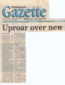
Article, Uproar over new units, 29/10/1997 12:00:00 AM
... The house was recognised in the 1994 City of Nunawading Heritage Survey Project and was classified as being of high local significance,...The house was recognised in the 1994 City of Nunawading Heritage Survey Project and was classified as being of high local significance, Uproar over new units Article Article ...Mitcham residents and the Nunawading and District Historical SocietyMitcham residents and the Nunawading and District Historical Society have joined the growing list of objectors to a proposed 16 unit development at the corner of Mitcham Road and Meerut Street on the site of one of the few remaining historical homes in the area. The house was built in 1934 by Stanley and Helen Walker. Mr Walker's family was owner and operator of the Australian Tessellated Tile Company, an important industry for Mitcham and Victoria. The house was recognised in the 1994 City of Nunawading Heritage Survey Project and was classified as being of high local significance,Mitcham residents and the Nunawading and District Historical Societymitcham road, mitcham, meerut street, walker, stanley, helen, arrowsmith, valda, daly, peter, seamer -
 City of Whittlesea
Photograph (item) - Photographs - Buildings, Hin Lim Photography, Blackbraes Farm, 21/6/2017
... Blackbraes Farm is listed in the Whittlesea Heritage Overlay HO14, Photographic survey, 10 Cravens Road Mernda...City of Whittlesea 25 Ferres Boulevard South Morang melbourne Blackbraes Farm is listed in the Whittlesea Heritage Overlay HO14, Photographic survey, 10 Cravens Road Mernda Blackbraes farm Mernda Photographs, Photographic report. ...Blackbraes Farm is listed in the Whittlesea Heritage Overlay HO14, Photographic survey, 10 Cravens Road Merndablackbraes farm, mernda -
 Stawell Historical Society Inc
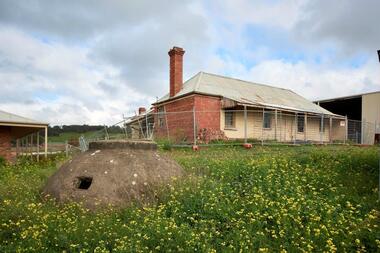
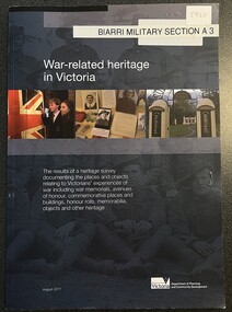
Book - Survey, War Related heritage in Victoria, August 2011
... Survey - Overview, veterans heritage in context, survey data, Victorian war Memorials, Lost & Rescued heritage, ase studies, Community collaboration case studies, Resources for veterans heritage organizations Stawell pp 86-89 - Photos and Text....War Related heritage in Victoria Book Survey ...Survey - Overview, veterans heritage in context, survey data, Victorian war Memorials, Lost & Rescued heritage, ase studies, Community collaboration case studies, Resources for veterans heritage organizations Stawell pp 86-89 - Photos and Text.Soft Cover: Background; Sepia group of Soldiers. Colour Photo Strip: children in front of U.J. Army Nurses. War memorial Gates. etc.Dept Premier and Cabinet! Hi Val, with compliments, Cathy Nash -
 Warrnambool and District Historical Society Inc.
Booklet - Booklet Collection: City of Warrnambool Tourist Guides, Collett, Bain and Gaspar, Warrnambool
... The front page has a Warrnambool premier town logo 1979-1982 and blue printing and a visitor survey. [.11] A conference pack of light card folded to make a pocket containing three brochures, a shipwreck coast tourist directory and a Australian Heritage Parks Association conference program dated 24 to 27 May 1992. ...The front page has a Warrnambool premier town logo 1979-1982 and blue printing and a visitor survey. [.11] A conference pack of light card folded to make a pocket containing three brochures, a shipwreck coast tourist directory and a Australian Heritage Parks Association conference program dated 24 to 27 May 1992. ...This is a collection of sixteen tourist guides dating from the mid 1970's to 2013. These contain listings of businesses, accommodation, eateries and events in Warrnambool and district. They also include maps of Warrnambool and surrounds, advertising and photographs of various attractions. While mainly covering Warrnambool a small number of the guides cover the South West Region. These directories have mainly been published by the Warrnambool City Council and are a selection of the types of information provided to visitors at the Tourist information centre during this time period.These tourist guides give snapshots of the City of Warrnambool for the years covered and will be useful for research.[.1] An 8 page paper booklet with black printing and a black & white photo of the pond at the Botanical Gardens on the front cover. [.2] two photocopied A4 black and white pages from the book "On the Trail" K Winser 1956 (Main Roads of Australia) [.3] A trifold colour brochure with a stylised map of the coast on the yellow and blue front cover. The inside has stylised colour drawings on Warrnambool attractions. The rear cover has coloured photographs of bush, Liebig Street and Fletcher Jones gardens [.4] A trifold black and white brochure with a black line drawing of a whale on the front cover. [.5] A trifold white card with mauve printing. The front cover has a line drawing of the former Timor Street post office and a map of businesses and landmarks in Timor Street. The reverse side contains a brief history of Warrnambool. [.6] A 98 page stapled booklet with a foreword by Vanda Savill. There are 4 pages of coloured photographs. The remainder are black and white photographs. The front cover is purple with white writing in the lower third. There is an outline of the coast and five colour photographs of district attractions. The inside middle page has a map of the Western wonderland region. The content covers towns in this area. Content relating to Warrnambool is in the last six pages. [.7] Twelve loose photocopied black and white pages. The front cover has the Warrnambool Premier Town 1988-1991 logo and a photo of a Southern Right Whale and calf. The bottom right hand corner has a Standard Warrnambool logo. [.8] 44 page booklet printed with blue ink. The staples have been removed. The glossy front cover has blue printing with a coloured photo of Flagstaff Hill Maritime Village pond. The centre pages has a fold out map of the City of Warrnambool. The rear cover has photos of The Twelve Apostles and Hopkins Falls. [.9] 4 loose photocopied pages with Warrnambool Library and Corangamite Regional Library Service Warrnambool City Library black ink stamps. The front page line drawing illustrations of Warrnambool attractions [.10] A single sheet of glossy white paper folded in half to make four pages. The front page has a Warrnambool premier town logo 1979-1982 and blue printing and a visitor survey. [.11] A conference pack of light card folded to make a pocket containing three brochures, a shipwreck coast tourist directory and a Australian Heritage Parks Association conference program dated 24 to 27 May 1992. The front cover of the pack has green writing over a stylised upward arrow. There is a City of Warrnambool logo in the top right hand corner and two film strips diagonally across the cover containing photographs of Warrnambool. The rear cover has a coloured Warrnambool Premier Town logo. [.12] A 63 page stapled booklet with coloured photographs of Warrnambool. The front cover has black writing on white background. There is a coloured photograph of Flagstaff Hill in the middle of the cover and a Warrnambool City and Visit Victoria logos on the lower edge. The middle pages has a coloured of the city of Warrnambool with an inset map of Allansford. [.13] A single large sheet of white paper folded in ten to make a brochure. The front cover has black printing. The rear cover has a purple ink stamp for the City of Warrnambool Tourist Information Centre. When folded out the reverse side has a green, grey and white map of the South West Region of Victoria. [.14] A 48 page colour booklet on glossy paper. The front cover has white writing on a blue background and includes photographs of the Twelve Apostles, the Promenade walk, Flagstaff Hill and a southern right whale's tail. The rear cover has photographs of The Twelve apostles, a passenger train from Melbourne passing the Lake Pertobe playground, and a rural scene. There is white writing and a white Warrnambool City logo on a blue background. The centre pages have a stylised green and blue map of the city of Warrnambool. [.15] A 48 page colour booklet on glossy paper. The front cover has white writing over colour photographs of two people at a lookout, Flagstaff Hill, three southern right whales and a child at the Lake Pertobe playground. The lower edge has blue upper case writing on a white background. The rear cover has a colour photograph of the Twelve Apostles. The lower white border on the rear covers has a a blue and green City of Warrnambool logo and blue writing. The centre pages have a stylised green and blue map of the city of Warrnambool. [.16] A 64 page colour booklet on glossy paper. The front cover has black writing on a black background and there is a photograph of a southern right whale's tail. The lower edge has the Warrnambool City and Visit Victoria Logos. The centre pages have maps of Warrnambool and surrounds. [.1] This week in Warrnambool Vol 2 No. 5 Thurs 1st Feb. For the time of your life [.2] Warrnambool Way [.3] Warrnambool The Holiday Host on the South West Coast with compliments City of Warrnambool and Warrnambool Chamber of Commerce [.4] MMI Insurance presents Whales Giants of the Deep Whale Watcher's Logbook Warrnambool [.5] Warrnambool History began in Timor Street [.6] Western Wonderland Tourist Association [.7] A Premier Arrow Tour of Warrnambool Victoria's Premier Town Australia's Southern Right Whale Nursery [.8] Warrnambool The Heart of Victoria's Great Southwest Visitor's Handbook [.9] What to see in Warrnambool Victoria's Premier City 1979-1982 [.10] Win a Free Holiday & $200 Cash in Victoria's Premier Town [.11] Advancing Warrnambool together! [.12] Great Ocean Road Warrnambool Official Visitor Guide [.13] Tourist guide to the South West Region Victoria All it needs is you [.14] Warrnambool visitor guide 2005 the great ocean road experience attractions accommodation entertainment dining [.15] Warrnambool Visitor Guide 2006 the great ocean road experience Attractions Accommodation Entertainment Dining [.16] Official Visitors' Guide Warrnambool Victoria Australia Discover the Great Ocean Road warrnambool, warrnambool tourist guides -
 Warrnambool and District Historical Society Inc.
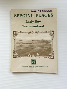
Pamphlet - Special Places Lady Bay Warrnambool, Philprint Warrnambool, 1989
... Heritage Week, April 16-23, 1989 and contains information written by Warrnambool residents about their locality. This was a co-operative venture by people with a common interest in protecting the natural environment near their home. Areas covered in the written information include: Formation of the Coast, Archaeological survey...Heritage Week, April 16-23, 1989 and contains information written by Warrnambool residents about their locality. This was a co-operative venture by people with a common interest in protecting the natural environment near their home. Areas covered in the written information include: Formation of the Coast, Archaeological survey ...This pamphlet was produced for the Warrnambool Branch of the National Trust of Australia (Victoria) for Heritage Week, April 16-23, 1989 and contains information written by Warrnambool residents about their locality. This was a co-operative venture by people with a common interest in protecting the natural environment near their home. Areas covered in the written information include: Formation of the Coast, Archaeological survey, Gunditjmara History, vegetation, history and recreational uses of the Lady Bay area. The map shows special places of interest including past and present navigational aids, sites of shipwrecks and other historical places of interest. The Warrnambool Branch of the National Trust was originally formed in March 1969 and merged with the Port Fairy Branch in late 1970. In October 1979, the Warrnambool Branch was reformed and operated into the late 1990's. This is an example of a publication produced by the Warrnambool Branch of the National Trust Australia (Victoria). It provides historical information and perspectives of the recreational uses in and around Lady Bay Warrnambool.An A2 piece of buff coloured thick paper folded into eight to make an A5 pamphlet. The front cover has green printing with the National Trust symbol of three eucalyptus leaves in green. There is a brown sepia photograph showing a view across Lady Bay with the suspension bridge across the Merri River in the foreground, Viaduct Road in the middle ground and the breakwater in the background. There is a purple inked stamp on the top right hand corner. The rear cover has brown writing and includes logos of bodies who assisted with the publication. There is a brown line drawing of the viaduct and pier at the Warrnambool Breakwater. The inside of the unfolded pamphlet contains a map of Lady Bay and adjacent area showing places of interest and shipwrecks marked in red circlesFront cover: Special Places Lady Bay Warrnambool National Trust of Australia (Victoria) Warrnambool Branch Ronald J. Cummingwarrnambool, lady bay warrnambool, national trust australia victoria warrnambool branch, heritage week 1989, lady bay shipwrecks -
 Bendigo Military Museum
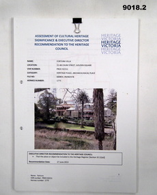
Document - Heritage Victoria Assessment of Cultural Heritage - Fortuna Villa, Heritage Victoria, October 2013
... Survey Regiment...Army Svy Regt...ASR...Heritage...Heritage Council of Victoria. 9018.2 while almost identical to 9018.1 in content does have additional information in red. Fortuna Villa was the family home of George Lansell the "Gold King" of Bendigo prior to being occupied by the Australian Army's Land Headquarters Cartographic Coy in WWII from 1942. The Army Survey...Heritage Council of Victoria. 9018.2 while almost identical to 9018.1 in content does have additional information in red. Fortuna Villa was the family home of George Lansell the "Gold King" of Bendigo prior to being occupied by the Australian Army's Land Headquarters Cartographic Coy in WWII from 1942. The Army Survey ...These documents 9018.1 and .2 discuss the significant Cultural Heritage value of Fortuna Villa and is a report regarding the acceptance of the Heritage Values by the Heritage Council of Victoria. 9018.2 while almost identical to 9018.1 in content does have additional information in red. Fortuna Villa was the family home of George Lansell the "Gold King" of Bendigo prior to being occupied by the Australian Army's Land Headquarters Cartographic Coy in WWII from 1942. The Army Survey Regiment was disbanded in 1996 and Defence left the site in 2004..1 A A4 Paper Heritage Report of Fortuna Villa. 26 x Pages of the Assessment part of the document, further 24 x Pages are the City of Greater Bendigo discussions of Heritage permit Exemptions. The document is two hole punched and held together with a metal Arnos fastener. .2 A second copy of the document containing 32 x unnumbered loose Pages held together with a small "bulldog" clip. Name Fortuna, VHR Number : PROV H2211, Hermes Number 1775royal australian survey corps, rasvy, fortuna, army survey regiment, army svy regt, asr, heritage victoria -
 Kiewa Valley Historical Society
Collection of Papers and Books re - Mt Beauty Heritage Centre
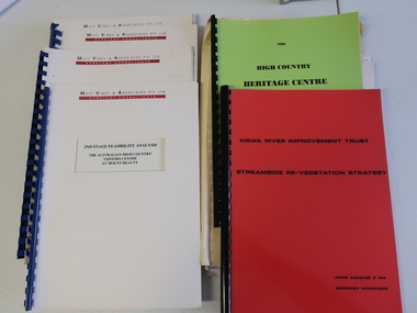
... Heritage Centre - Matt Viney & Associates - white spiral folders 6. Landscape Consultants - Susan Campbell & son - red spiral folder 7. Plant List - Upper Kiewa Valley Water Supply Catchment 8. Geological Survey...Mt Beauty Heritage Centre Mt Beauty Discovery Centre Geological Surveys 1. Bogong - The Alpine Discovery Centre 2. ...In the early 1990s the KVHS applied for a grant to create the Mt Beauty Heritage Centre / Discovery Centre. This involved employing consultants and further research.This collection includes a lot of detail of the Kiewa Valley area.1. Bogong - The Alpine Discovery Centre 2. Heritage Centre - black folder 3. Heritage Centre - manila folder 4. High Country Heritage Centre - 1991 - green spiral folder 5. Six Heritage Centre - Matt Viney & Associates - white spiral folders 6. Landscape Consultants - Susan Campbell & son - red spiral folder 7. Plant List - Upper Kiewa Valley Water Supply Catchment 8. Geological Survey of Vic., Plates, Bulletin No. 44 - in battered paper 'bag' with front cover list of contents - 15 plates 9. Geological Survey - A3 photo copies of pages 106-117 10. Geological Survey of Vic. - Report of Progress No VII 1884 - bound book 11. Geological Survey of Vic. Bulletin 56 - includes nth east Vic. 1958 - bound book with green cloth spine 12. Department of Mines Report Vic. 1906 - booklet held with two staples 13. Royal Society of Vic book - The Geology of the Kiewa Area 1961 14. Miscellaneous papers - Geological Survey, Reports of Fossil Specimens and maps of local area 15. Gold - Appendix K and Appendix 111, Part C - photocopied pages from Vic Mining Registrars Report 1888 - manila foldermt beauty heritage centre, mt beauty discovery centre, geological surveys -
 Kiewa Valley Historical Society
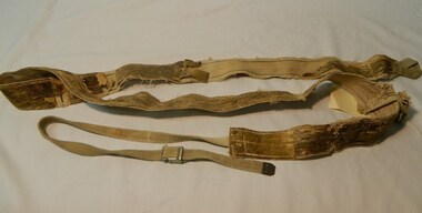
Seal Skins Ski Straps / Soles, mid 1900's
... survey work for the SEC Hydro scheme in the late 1930s. This period in time produced many immigrants from a war torn Europe with highly developed technical skills. Many of these immigrants provided articles that were well suited to the alpine regions of Australia, ones they used in their homelands. These were times when the home grown cultures of the Anglo Saxon heritage...survey work for the SEC Hydro scheme in the late 1930s. This period in time produced many immigrants from a war torn Europe with highly developed technical skills. Many of these immigrants provided articles that were well suited to the alpine regions of Australia, ones they used in their homelands. These were times when the home grown cultures of the Anglo Saxon heritage ...These seal skin straps and webbing were introduced into the Victorian Alps by European engineers, conducting survey work for the SEC Hydro scheme in the late 1930s. This period in time produced many immigrants from a war torn Europe with highly developed technical skills. Many of these immigrants provided articles that were well suited to the alpine regions of Australia, ones they used in their homelands. These were times when the home grown cultures of the Anglo Saxon heritage of the earlier settlers within the Kiewa Valley became interwoven with the various European cultures and this formed, what in later years became the beginning of the Australian multi-cultural society. The Kiewa Valley and its surrounding regions where the major rural areas which did not progress in a so typical Aussie "dinky-di", "she'll be right" fashion. The European influence was however not too strong, so as to obliterate the flavour of the home grown rural society.The major populated sections of the upper Kiewa Valley and the Alpine regions were accelerated by the SEC Hydro Development which brought into the slow growing rural regions a quasi multi ethnic society, however this was only noticeable up to the time when the final Power Station was commissioned in the 1960s. The slight variations to the typical Australian rural settlements of the time were in some food preparations, winter apparel such as these seal skin straps and soles and "langlauf" (cross-country skis). The sealskins were sewn so that their grain ran from front to back thereby allowing the skins to grip going up hill and glide going downhill.The gardens and varieties of flowering shrubs and trees where also more in line with traditional European "outdoor" settings. Seal skin sewn onto one side of a strap of webbing. There is a webbing loop on the front that slips over a small point at the front of the ski. There is a webbing strap attached to the back of the seal skin sole coming over the back of ski that clips metal fasteners onto a loop of webbing behind the ski boot. alpine sports, snow skis, winter clothing, mount bogong recreational activities, snow sports -
 Emerald Museum & Nobelius Heritage Park
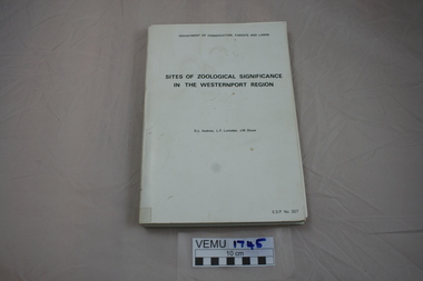
Book, Sites of Zoological Significance in the Westernport Region, 1984
... Emerald Museum & Nobelius Heritage Park 5 Crichton Rd Emerald yarra-valley-and-the-dandenong-ranges Zoological Significance. The report contains the results of a survey of the vertebrate fauna of the Westernport catchment and a search of relevant literature, conducted between June 1979 and December 1981. ...Zoological Significance. The report contains the results of a survey of the vertebrate fauna of the Westernport catchment and a search of relevant literature, conducted between June 1979 and December 1981.White soft cover thick book, about A4 size. Prepared by the national Museum of Victoria for The Environmental Studies Division, Ministry of Conservation, Victoria 1984. -
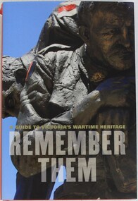 4th/19th Prince of Wales's Light Horse Regiment Unit History Room
Book, A Guide to Victoria's Wartime Heritage. Remember Them, 2009
... This comprehensive survey of Victoria's memorial landscape will be an invaluable starting point for teachers and students who are exploring its impact in their community" John Taylor Chairman, Shrine of Remembrance war memorials victoria history war memorials victoria history ISBN 978 1 74066 840 8 Hardcover book of 308 pages A Guide to Victoria's Wartime Heritage. ..."Australia's involvement in war and peacekeeping operations has touched almost every town, large and small, in Victoria. This comprehensive survey of Victoria's memorial landscape will be an invaluable starting point for teachers and students who are exploring its impact in their community" John Taylor Chairman, Shrine of RemembranceHardcover book of 308 pagesISBN 978 1 74066 840 8war memorials, victoria, history, war memorials, victoria, history -
 Emerald Museum & Nobelius Heritage Park
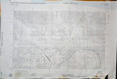
Map - Melbourne & Metropolitan Board of Works, Emerald Victoria, Topographical Map - Amendment 16.1.89, Melbourne and Metropolitan Board of Works, MMBW Topographical Map -Yarra 2500/28.01, 1989
... Emerald Museum & Nobelius Heritage Park 5 Crichton Rd Emerald yarra-valley-and-the-dandenong-ranges Emerald Topographical map of Emerald township from 1989, based on photography from 1981 Lodged plans marked * have easements omitted/Lot boundaries are based on occupation and are not necessarily title/The grid lines on this sheet represent the A.M.G. plan boundaries for the 1:500 series. The reference number of the 1:500 series plan in the S.W corner of this sheet is YARRA500/136-001/Topography from the photogrammetry compiled by Australian Aerial Mapping (Vic.) Pty.Ltd. Date of Photography: January 1981/Base prepared by the Survey ...Topographical map of Emerald township from 1989, based on photography from 1981Image of printed Melbourne & Metropolitan Board of Works topographical map - Emerald - Yarra 2500/28.01non-fictionTopographical map of Emerald township from 1989, based on photography from 1981emerald -
 Emerald Museum & Nobelius Heritage Park
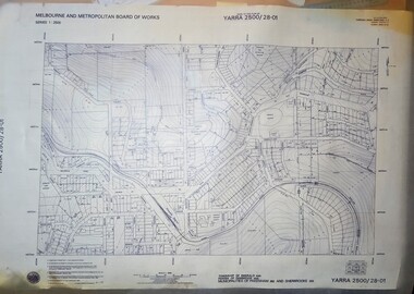
Map - Transparency edition - Melbourne & Metropolitan Board of Works, Emerald Victoria, Topographical Map - Amendment 16.1.89, Melbourne and Metropolitan Board of Works, MMBW Topographical Map -Yarra 2500/28.01, 1989
... Emerald Museum & Nobelius Heritage Park 5 Crichton Rd Emerald yarra-valley-and-the-dandenong-ranges Emerald Topographical map of Emerald township from 1988 Lodged plans marked * have easements omitted/Lot boundaries are based on occupation and are not necessarily title/The grid lines on this sheet represent the A.M.G. plan boundaries for the 1:500 series. The reference number of the 1:500 series plan in the S.W corner of this sheet is YARRA500/136-001/Topography from the photogrammetry compiled by Australian Aerial Mapping (Vic.) Pty.Ltd. Date of Photography: January 1981/Base prepared by the Survey ...Topographical map of Emerald township from 1988Image of printed Melbourne & Metropolitan Board of Works topographical map - Emerald - Yarra 2500/28.01non-fictionTopographical map of Emerald township from 1988emerald -
 Emerald Museum & Nobelius Heritage Park
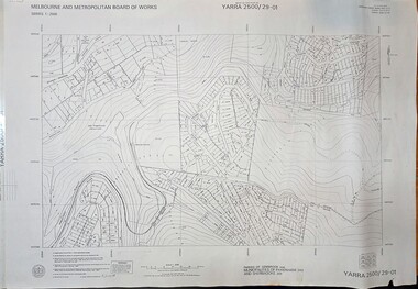
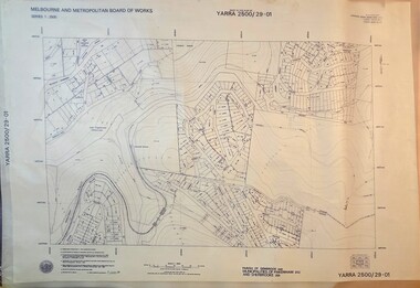
Map - Melbourne & Metropolitan Board of Works, Emerald Victoria, Topographical Map - Amendment 5.1.88, Melbourne and Metropolitan Board of Works, MMBW Topographical Map -Yarra 2500/29.01, 1988
... Emerald Museum & Nobelius Heritage Park 5 Crichton Rd Emerald yarra-valley-and-the-dandenong-ranges Emerald Topographical map of Emerald township from 1989, based on photography from 1981 Lodged plans marked * have easements omitted/Lot boundaries are based on occupation and are not necessarily title/The grid lines on this sheet represent the A.M.G. plan boundaries for the 1:500 series. The reference number of the 1:500 series plan in the S.W corner of this sheet is YARRA500/141-001/Topography from the photogrammetry compiled by Australian Aerial Mapping (Vic.) Pty.Ltd. Date of Photography: January 1984/Base prepared by the Survey ...Topographical map of Emerald township from 1989, based on photography from 1981Image of printed Melbourne & Metropolitan Board of Works topographical map - Emerald - Yarra 2500/29.01non-fictionTopographical map of Emerald township from 1989, based on photography from 1981emerald -
 Emerald Museum & Nobelius Heritage Park
Map - Transparency of Melbourne & Metropolitan Board of Works, Emerald Victoria, Topographical Map - Amendment 5.1.88, Melbourne and Metropolitan Board of Works, MMBW Topographical Map -Yarra 2500/29.01, 1988
... Emerald Museum & Nobelius Heritage Park 5 Crichton Rd Emerald yarra-valley-and-the-dandenong-ranges Emerald Topographical map of Emerald township from 1988 Lodged plans marked * have easements omitted/Lot boundaries are based on occupation and are not necessarily title/The grid lines on this sheet represent the A.M.G. plan boundaries for the 1:500 series. The reference number of the 1:500 series plan in the S.W corner of this sheet is YARRA500/141-001/Topography from the photogrammetry compiled by Australian Aerial Mapping (Vic.) Pty.Ltd. Date of Photography: January 1984/Base prepared by the Survey ...Topographical map of Emerald township from 1988Image transparency of printed Melbourne & Metropolitan Board of Works topographical map - Emerald - Yarra 2500/29.01non-fictionTopographical map of Emerald township from 1988emerald -
 Emerald Museum & Nobelius Heritage Park
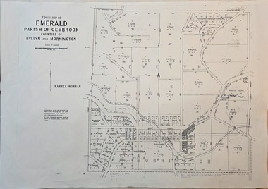
Map - Image of surveyor's map of the Township of Emerald, Surveyors map, Emerald Township 1955, c1955
... Emerald Museum & Nobelius Heritage Park 5 Crichton Rd Emerald yarra-valley-and-the-dandenong-ranges Emerald township map c1955 Township of Emerald/parish of Gembrook/Counties of Evelyn & Mornington/By Authority W.M.Huston, Government Printer/Drawn and reproduced at the Dept. of Lands and Survey, Melbourne, Victoria, September 1955 Image of surveyor's map - Township of Emerald 1955 Surveyors map, Emerald Township 1955 Map Image of surveyor's map of the Township of Emerald ...Emerald township map c1955Image of surveyor's map - Township of Emerald 1955Township of Emerald/parish of Gembrook/Counties of Evelyn & Mornington/By Authority W.M.Huston, Government Printer/Drawn and reproduced at the Dept. of Lands and Survey, Melbourne, Victoria, September 1955 -
 Emerald Museum & Nobelius Heritage Park
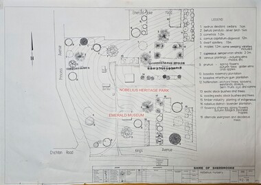
Map - Image of Nobelius Nursery - site of plants notated, Survey map of the Nobelius nursery, Unknown
... Image of a survey may showing Nobelius Nursery in Nobelius heritage park...Emerald Museum & Nobelius Heritage Park 5 Crichton Rd Emerald yarra-valley-and-the-dandenong-ranges Plant map of the Nobelius Nursery, Nobelius heritage Park Shire of Sherbrooke/Nobelius Nursery/R2-38/Legen (Plant type and location? Image of a survey may showing Nobelius Nursery in Nobelius heritage park Survey map of the Nobelius nursery Map Image of Nobelius Nursery - site of plants notated ...Plant map of the Nobelius Nursery, Nobelius heritage ParkImage of a survey may showing Nobelius Nursery in Nobelius heritage parkShire of Sherbrooke/Nobelius Nursery/R2-38/Legen (Plant type and location? -
 Emerald Museum & Nobelius Heritage Park
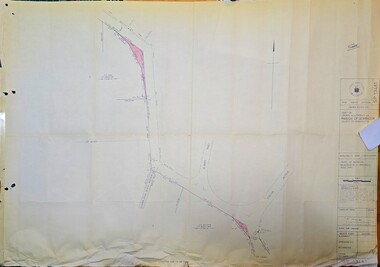
Map - Surveyors map of Wellington Rd. near Magpie Rd., Clematis, Part of Crown allotments 106E and 106G2, survey map of Wellington Rd., near Magpie Rd. 1972, c1972
... Emerald Museum & Nobelius Heritage Park 5 Crichton Rd Emerald yarra-valley-and-the-dandenong-ranges Title Survey Division/Crown Description/Part of Crown Allotments 106E and 106G2/Parish of Narree Worran, County of Mornington/Cardinia/Shire of Sherbrooke, Wellington Road/Rossley Paul Gardiner of Kirkpatrick & Webber, 289 Maroondah Hwy, Ringwood/Signed S.R. ...Image of Surveyors map outlining part of Wellington Rd., Near Magpie Rd., Clematis 1972Title Survey Division/Crown Description/Part of Crown Allotments 106E and 106G2/Parish of Narree Worran, County of Mornington/Cardinia/Shire of Sherbrooke, Wellington Road/Rossley Paul Gardiner of Kirkpatrick & Webber, 289 Maroondah Hwy, Ringwood/Signed S.R. Clarke 21.6.72/B.A. Gibson C/T 8047/414 subtract 0.01 1/2 for Title -
 Emerald Museum & Nobelius Heritage Park
Map - Surveyors map of Wellington Rd. near Magpie Rd., and Paradise Rd., Clematis, Part of Crown allotments 106E and 106G2, survey map of Wellington Rd., near Magpie Rd. and Paradise Rd., Clematis 1972, c1972
... Emerald Museum & Nobelius Heritage Park 5 Crichton Rd Emerald yarra-valley-and-the-dandenong-ranges Title Survey Division/Crown Description/Part of Crown Allotments 106F2 and 106G1/Parish of Narree Worran, County of Mornington/Cardinia/Shire of Sherbrooke, Wellington Road/Rossley Paul Gardiner of Kirkpatrick & Webber, 289 Maroondah Hwy, Ringwood/Signed S.R. ...Image of Surveyors map outlining part of Wellington Rd., Near Magpie Rd. and Paradise Rd., Clematis 1972Title Survey Division/Crown Description/Part of Crown Allotments 106F2 and 106G1/Parish of Narree Worran, County of Mornington/Cardinia/Shire of Sherbrooke, Wellington Road/Rossley Paul Gardiner of Kirkpatrick & Webber, 289 Maroondah Hwy, Ringwood/Signed S.R. Clarke 21.6.72 -
 Emerald Museum & Nobelius Heritage Park
Map - Surveyors map of Wellington Rd. near Magpie Rd., and Paradise Rd., Clematis, Part of Crown allotments 106F2 and 106G1, survey map of Wellington Rd., near Magpie Rd. and Paradise Rd., Clematis 1972, c1972
... Emerald Museum & Nobelius Heritage Park 5 Crichton Rd Emerald yarra-valley-and-the-dandenong-ranges Title Survey Division/Crown Description/Part of Crown Allotments 106F2 and 106G1/Parish of Narree Worran, County of Mornington/Cardinia/Shire of Sherbrooke, Wellington Road/Rossley Paul Gardiner of Kirkpatrick & Webber, 289 Maroondah Hwy, Ringwood/Signed S.R. ...Image of Surveyors map outlining part of Wellington Rd., Near Magpie Rd. and Paradise Rd., Clematis 1972Title Survey Division/Crown Description/Part of Crown Allotments 106F2 and 106G1/Parish of Narree Worran, County of Mornington/Cardinia/Shire of Sherbrooke, Wellington Road/Rossley Paul Gardiner of Kirkpatrick & Webber, 289 Maroondah Hwy, Ringwood/Signed S.R. Clarke 21.6.72 -
 Emerald Museum & Nobelius Heritage Park
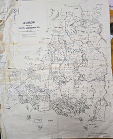
Map - Land Holding map issued by Lands Council Victoria - area south of Emerald township (now mostly under Cardinia Reservoir), Gembrook, Counties of Evelyn & Mornington land holding map 1967, c1967
... Emerald Museum & Nobelius Heritage Park 5 Crichton Rd Emerald yarra-valley-and-the-dandenong-ranges land holdings map showing holdings south of the main township of Emerald, much or which is now under the Cardinia Reservoir Gembrook G206 Sheet/Gembrook counties of Evelyn and Mornington/Compared with originals H.R. JOHNSON (22.8.68)/By Authority AC Brooks, Government Printer, Melbourne/Drawn and reproduced at the Department of Lands and Survey ...land holdings map showing holdings south of the main township of Emerald, much or which is now under the Cardinia ReservoirImage of land holdings map for area south of Emerald township in the counties of Evelyn & Mornington, GembrookGembrook G206 Sheet/Gembrook counties of Evelyn and Mornington/Compared with originals H.R. JOHNSON (22.8.68)/By Authority AC Brooks, Government Printer, Melbourne/Drawn and reproduced at the Department of Lands and Survey, Melbourne/Price $1.00 per sheet -
 Emerald Museum & Nobelius Heritage Park
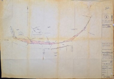
Map - Municipality Road Classification - Beaconsfield-Emerald Rd., Shire of Gembrook 1973, Title Survey Division, Crown Description - Part of Crown Allotment 44, Parish of Gembrook, County of Mornington, c1973
... Emerald Museum & Nobelius Heritage Park 5 Crichton Rd Emerald yarra-valley-and-the-dandenong-ranges Title Survey Division/Crown Description/Part of Crown Allotment 44, Parish of Gembrook, County of Mornington/Municipality Road Classification, Shire of Berwick, Beaconsfeld-Emerald Rd. ...Image of Crown Survey Map for crown allotment 44 (Beaconsfield-Emerald Rd.) parish of Gembrook, County of MorningtonTitle Survey Division/Crown Description/Part of Crown Allotment 44, Parish of Gembrook, County of Mornington/Municipality Road Classification, Shire of Berwick, Beaconsfeld-Emerald Rd. (MR)/Francis J Webber of Kirkpatrick & Webber, 285 Maroondah Hwy., Ringwood/(Signed) - Principal Title Survey Office 16.1.73/SP13461 -
 Emerald Museum & Nobelius Heritage Park
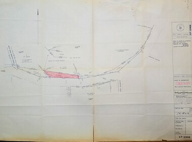
Map - Survey Map - Municipality Road Classification - Beaconsfield-Emerald Rd. (near Downey Rd.) 1972, Title Survey Division, Crown Description - part of Crown Allotments 39A and 39D, Parish of Gembrook, County of Mornington, c1972
... Emerald Museum & Nobelius Heritage Park 5 Crichton Rd Emerald yarra-valley-and-the-dandenong-ranges Title Survey Division/Crown Description/Part of Crown Allotments 39A and 39D, Parish of Gembrook,County of Mornington/Municipality Road Classification - Shire of Berwick, Beaconsfield - Emerald Rd, Upper Beaconsfield - Upper Pakenham Road/John L Dwyer of Fisher Cleeland Turner & Dwyer Pty. ...Image of Crown survey map - changes to allotments bordering Beaconsfield-Emerald Rd. near Downey Rd. in 1972Title Survey Division/Crown Description/Part of Crown Allotments 39A and 39D, Parish of Gembrook,County of Mornington/Municipality Road Classification - Shire of Berwick, Beaconsfield - Emerald Rd, Upper Beaconsfield - Upper Pakenham Road/John L Dwyer of Fisher Cleeland Turner & Dwyer Pty. Ltd., 213 King Street, Melbourne - 14 April, 1972/S.R. CLARKE - Principal Title Survey Officer 5.9.72/SP 13072