Showing 116 items matching "highbury road"
-
 Whitehorse Historical Society Inc.
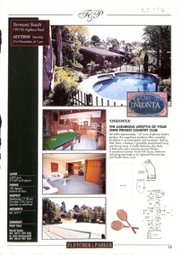
Pamphlet, 739 - 743 Highbury Road, Vermont South, 1/11/1998
... 739 - 743 Highbury Road, Vermont South...highbury road...Fletcher & Parker real estate pamphlet, p. 13: 4 Bedroom house on 1.67 acres, 739-743 Highbury Road, Vermont South, for auction 21 November 1998....Whitehorse Historical Society Inc. 2-10 Deep Creek Road Mitcham melbourne highbury road vermont south nos 739-743. fletcher and parker auctions Fletcher & Parker real estate pamphlet, p. 13: 4 Bedroom house on 1.67 acres, 739-743 Highbury Road, Vermont South, for auction 21 November 1998. 739 - 743 Highbury Road, Vermont South Pamphlet Pamphlet ...Fletcher & Parker real estate pamphlet, p. 13: 4 Bedroom house on 1.67 acres, 739-743 Highbury Road, Vermont South, for auction 21 November 1998.highbury road, vermont south, nos 739-743., fletcher and parker, auctions -
 Whitehorse Historical Society Inc.
Map, Highbury Road, c1970
... Highbury Road...Highbury Road...Enlarged aerial photo of Highbury Park area. Highbury Road Map Map ...Enlarged aerial photo of Highbury Park area.Enlarged aerial photo of Highbury Park area.Enlarged aerial photo of Highbury Park area.highbury road, burwood east, gareth drive, burwood east, blackburn road, burwood east, bennett avenue, burwood east, rae street, burwood east, joy street, burwood east, folkestone road, burwood east, burwood east primary school no. 454, aerial photographs -
 Whitehorse Historical Society Inc.
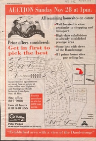
Newspaper - Article, Tally Ho Greens, 17/11/1993
... ...highbury road...Bordered by Springvale Road and Highbury Road, 28-11-1993....Advertisement in the Post for auction of 81 home sites on the Tally Ho Estate bordered by Springvale Road and Highbury Road, 28-11-1993....Whitehorse Historical Society Inc. 2-10 Deep Creek Road Mitcham melbourne Bordered by Springvale Road and Highbury Road, 28-11-1993. auctions springvale road burwood east highbury road robinson drive hoadley crescent betts way trainor place sutton court cole close mcclelland way kennard place vision drive Advertisement in the Post for auction of 81 home sites on the Tally Ho Estate. ...Advertisement in the Post for auction of 81 home sites on the Tally Ho Estate.Advertisement in the Post for auction of 81 home sites on the Tally Ho Estate bordered by Springvale Road and Highbury Road, 28-11-1993.Advertisement in the Post for auction of 81 home sites on the Tally Ho Estate. auctions, springvale road, burwood east, highbury road, robinson drive, hoadley crescent, betts way, trainor place, sutton court, cole close, mcclelland way, kennard place, vision drive -
Whitehorse Historical Society Inc.
Document, History of Tally Ho Boys Home, 1972
... ...Highbury Road...The farm was built on land bought from Abel Hoadley for 1,000 Pounds near the corner of Springvale Road in Boundary Road (now Highbury Road). 2 letters (16/7/1972 & 28/5/1972) to Nancy Leach from E. ...3 papers on History of Boys Training Farm, Highbury Road, Tally Ho, commenced in 1903 by Rev. and Mrs George Cole. ...Three papers on History of Boys Training Farm, Highbury Road, Tally Ho 3 papers on History of Boys Training Farm, Highbury Road, Tally Ho, commenced in 1903 by Rev. and Mrs George Cole. ...Three papers on History of Boys Training Farm, Highbury Road, Tally Ho3 papers on History of Boys Training Farm, Highbury Road, Tally Ho, commenced in 1903 by Rev. and Mrs George Cole. The story covers the period from 1903-1930. The farm was built on land bought from Abel Hoadley for 1,000 Pounds near the corner of Springvale Road in Boundary Road (now Highbury Road). 2 letters (16/7/1972 & 28/5/1972) to Nancy Leach from E. Hinneberg, Assistant Superintendent, Tally Ho, about his association with Tally Ho.Three papers on History of Boys Training Farm, Highbury Road, Tally Hoyouth services, tally ho boys home, cole, george, rev., cole, mrs, hoadley, abel, boundary road burwood east, highbury road, burwood east, springvale road, burwood east, leach, nancy, hinneberg, ernest. -
 Whitehorse Historical Society Inc.
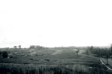
Photograph, Subdivision of Area of Burwood, 1971
... highbury road...Black and white photo of Subdivision of Area of Burwood, Springvale and Highbury Roads....Whitehorse Historical Society Inc. 2-10 Deep Creek Road Mitcham melbourne highbury road burwood east springvale road burwood highway burwood east Subdivision Black and white photo of Subdivision of Area of Burwood, Springvale and Highbury Roads. ...Black and white photo of Subdivision of Area of Burwood, Springvale and Highbury Roads.highbury road, burwood east, springvale road, burwood highway burwood east, subdivision -
Whitehorse Historical Society Inc.
Map, Springvale Road, 1968
... ...Highbury Road...Aerial photograph of cnr Springvale Road and Burwood Highway, south past Highbury Road....Aerial photograph of cnr Springvale Road and Burwood Highway, south past Highbury Road. Springvale Road Map Map ...Aerial photograph of cnr Springvale Road and Burwood Highway, south past Highbury Road.Aerial photograph of cnr Springvale Road and Burwood Highway, south past Highbury Road.Aerial photograph of cnr Springvale Road and Burwood Highway, south past Highbury Road.aerial photographs, highbury road, burwood east, burwood highway, burwood east, springvale road, burwood east -
 Whitehorse Historical Society Inc.
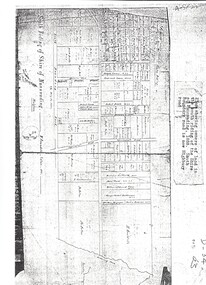
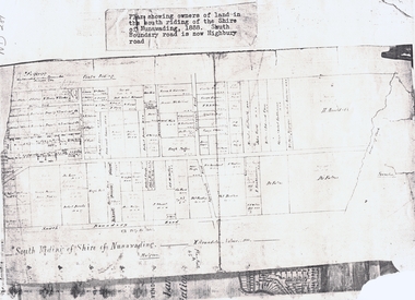
Map, Shire of Nunawading 1888
... ...highbury road...South Boundary Road is now Highbury Road....South Boundary Road is now Highbury Road. Shire of Nunawading 1888 Map Map ...Plan showing owners of land in the South Riding of the Shire of Nunawading, 1888. South Boundary Road is now Highbury Road.shire of nunawading. south riding, south boundary road, burwood east, highbury road, springvale road, mahoneys road, forest hill, holland road, blackburn south, burwood highway -
Whitehorse Historical Society Inc.
Legal record - Land Title, Springvale Road, 1960
... ...Highbury Road...Springvale Road and Burwood Highway, south past Highbury Road and east to Vermont South....Springvale Road and Burwood Highway, south past Highbury Road and east to Vermont South. Aerial photograph of cnr. ...Aerial photograph of cnr. Springvale Road and Burwood Highway, south past Highbury Road and east to Vermont South.Aerial photograph of cnr. Springvale Road and Burwood Highway, south past Highbury Road and east to Vermont South.Aerial photograph of cnr. Springvale Road and Burwood Highway, south past Highbury Road and east to Vermont South.aerial photographs, springvale road, burwood east, burwood highway, burwood east, highbury road, burwood east, vermont south -
Whitehorse Historical Society Inc.
Map, Springvale Road, 1987
... ...Highbury Road...Aerial photograph of cnr Springvale Road and Burwood Highway, south past Highbury Road and west past Blackburn Road....Whitehorse Historical Society Inc. 2-10 Deep Creek Road Mitcham melbourne Aerial photographs Blackburn Road Burwood East Highbury Road Burwood East Burwood Highway Burwood East Springvale Road Burwood East Burwood East Aerial photograph of cnr Springvale Road and Burwood Highway, south past Highbury Road and west past Blackburn Road. ...Aerial photograph of cnr Springvale Road and Burwood Highway, south past Highbury Road and west past Blackburn Road.Aerial photograph of cnr Springvale Road and Burwood Highway, south past Highbury Road and west past Blackburn Road.Aerial photograph of cnr Springvale Road and Burwood Highway, south past Highbury Road and west past Blackburn Road.aerial photographs, blackburn road, burwood east, highbury road, burwood east, burwood highway, burwood east, springvale road, burwood east, burwood east -
Whitehorse Historical Society Inc.
Map, Springvale Road, 1981
... ...Highbury Road...Springvale Road and Burwood Highway, south past Highbury Road and west to Sevenoaks Road....Springvale Road and Burwood Highway, south past Highbury Road and west to Sevenoaks Road. Springvale Road Map Map ...Aerial photograph of area including cnr. Springvale Road and Burwood Highway, south past Highbury Road and west to Sevenoaks Road.Aerial photograph of area including cnr. Springvale Road and Burwood Highway, south past Highbury Road and west to Sevenoaks Road.Aerial photograph of area including cnr. Springvale Road and Burwood Highway, south past Highbury Road and west to Sevenoaks Road.aerial photographs, burwood east, springvale road, burwood east, burwood highway, burwood east, sevenoaks road, burwood east, highbury road, burwood east -
Whitehorse Historical Society Inc.
Map, Springvale Road, 1975
... ...Highbury Road...Aerial photograph of area around cnr. of Springvale Road and Burwood Highway, south past Highbury Road and East in Vermont South....Whitehorse Historical Society Inc. 2-10 Deep Creek Road Mitcham melbourne Aerial photographs Vermont South Highbury Road Burwood East Burwood Highway Burwood East Burwood East Aerial photograph of area around cnr. of Springvale Road and Burwood Highway, south past Highbury Road and East in Vermont South. ...Aerial photograph of area around cnr. of Springvale Road and Burwood Highway, south past Highbury Road and East in Vermont South.Aerial photograph of area around cnr. of Springvale Road and Burwood Highway, south past Highbury Road and East in Vermont South.Aerial photograph of area around cnr. of Springvale Road and Burwood Highway, south past Highbury Road and East in Vermont South.aerial photographs, vermont south, highbury road, burwood east, burwood highway, burwood east, burwood east -
Whitehorse Historical Society Inc.
Map, Nunawading Shire, 1892
... One map (Blackburn) from north of Whitehorse Road to Highbury Road, 2nd map (Mitcham) Bulleen to south of Canterbury Road; 3rd map Whitehorse Road to Highbury Road....One map (Blackburn) from north of Whitehorse Road to Highbury Road, 2nd map (Mitcham) Bulleen to south of Canterbury Road; 3rd map Whitehorse Road to Highbury Road....One map (Blackburn) from north of Whitehorse Road to Highbury Road, 2nd map (Mitcham) Bulleen to south of Canterbury Road; 3rd map Whitehorse Road to Highbury Road. ...Photocopy of an enlargement of map of Shire of Nunawading showing landowners in 1892.Photocopy of an enlargement of map of Shire of Nunawading showing landowners in 1892. Covers Middleborough Road to Ringwood boundary. One map (Blackburn) from north of Whitehorse Road to Highbury Road, 2nd map (Mitcham) Bulleen to south of Canterbury Road; 3rd map Whitehorse Road to Highbury Road.Photocopy of an enlargement of map of Shire of Nunawading showing landowners in 1892. maps, shire of nunawading, blackburn, blackburn south, nunawading, forest hill, vermont, mitcham, vermont south -
Whitehorse Historical Society Inc.
Map, Springvale Road, 1990
... ...Highbury Road...Aerial photograph of cnr Springvale Road and Burwood Highway, south past Highbury Road, west to Middleborough Road and east to Morack Road Vermont South....Whitehorse Historical Society Inc. 2-10 Deep Creek Road Mitcham melbourne Aerial photographs Morack Road Vermont South Burwood Highway Burwood East Springvale Road Burwood East Highbury Road Burwood East Burwood East Vermont South Aerial photograph of cnr Springvale Road and Burwood Highway, south past Highbury Road, west to Middleborough Road and east to Morack Road Vermont South. ...Aerial photograph of cnr Springvale Road and Burwood Highway, south past Highbury Road, west to Middleborough Road and east to Morack Road Vermont South.Aerial photograph of cnr Springvale Road and Burwood Highway, south past Highbury Road, west to Middleborough Road and east to Morack Road Vermont South.Aerial photograph of cnr Springvale Road and Burwood Highway, south past Highbury Road, west to Middleborough Road and east to Morack Road Vermont South.aerial photographs, morack road, vermont south, burwood highway, burwood east, springvale road, burwood east, highbury road, burwood east, burwood east, vermont south -
 Whitehorse Historical Society Inc.
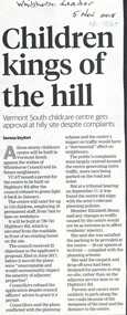
Article, Children Kings of the Hill, 2018
... ...highbury road...A three-storey childcare centre will be built at 739-745 Highbury Road, Vermont South against the wishes of Whitehorse Council and the future neighbours. ...Whitehorse Historical Society Inc. 2-10 Deep Creek Road Mitcham melbourne vermont south highbury road city of whitehorse A three-storey childcare centre will be built at 739-745 Highbury Road, Vermont South against the wishes of Whitehorse Council and the future neighbours. ...A three-storey childcare centre will be built at 739-745 Highbury Road, Vermont South against the wishes of Whitehorse Council and the future neighbours.A three-storey childcare centre will be built at 739-745 Highbury Road, Vermont South against the wishes of Whitehorse Council and the future neighbours. The application was approved by VCAT.A three-storey childcare centre will be built at 739-745 Highbury Road, Vermont South against the wishes of Whitehorse Council and the future neighbours.vermont south, highbury road, city of whitehorse -
Box Hill Historical Society
Photograph - Gardiners Creek
... ...Highbury Road...View of sculpture at Gardiner's Creek Reserve between Highbury Road and Burwood Highway. One of a collection of "Time" sculptures. ...December 1985 Sculpture Gardiners Creek Reserve Parks and reserves Highbury Road Burwood Highway Photograph Gardiners Creek ...View of sculpture at Gardiner's Creek Reserve between Highbury Road and Burwood Highway. One of a collection of "Time" sculptures. December 1985sculpture, gardiners creek reserve, parks and reserves, highbury road, burwood highway -
 Ithacan Historical Society
Photograph, Anthi Chilianis - House no. 11, 1994
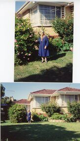
... 270 Highbury Road, Burwood, Victoria, Australia ...This is the eleventh house where Anthi Chilianis lived after the family returned from Ithaca in 1961, at 270 Highbury Street in Burwood.In the early years of Ithacan settlement in Melbourne most of the Ithacan community lived in the inner suburbs where they also had their businesses. As they became more established they then moved to the newer outer suburbs of Melbourne, areas such as Burwood, North Balwyn.Two coloured photographs of a lady in a dark blue dress standing in front of a cream brick veneer house in a garden, next to a flowering hibiscus shrub in a garden. -
Whitehorse Historical Society Inc.
Document, The 'Mullens House', n.d
... ...Highbury Road...Mr Mullen's parents lived in Highbury Road, near East Burwood Primary School and were pioneers of East Burwood....Mr Mullen's parents lived in Highbury Road, near East Burwood Primary School and were pioneers of East Burwood. ...Story of the 'Mullens House', originally small dwelling made of hand made bricks by Mrs Mullens' father, Mr Forbes of Glen Waverley. Came from Scotland 93 years ago. As the family increased more rooms were added. Hugh Mullens was a woodcutter and later an orchardist and later still a road contractor. Mrs Tainton, a daughter, still lives in part of the original property. Another daughter, Mrs Stocks who was a widow stayed on with her mother at the old home. It is now the property of Melbourne & Metropolitan Board of Works. Mr & Mrs Hugh Mullen's had 12 children. Mr Mullen's parents lived in Highbury Road, near East Burwood Primary School and were pioneers of East Burwood.hugh, forbes, tainton, r (mrs), stocks, (mrs), melbourne and metropolitan board of works, highbury road, mullen's -
 Kew Historical Society Inc
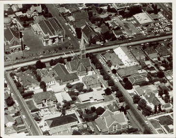
Photograph - Aerial photograph of Cotham Road and Highbury Grove, Kew, c.1970
... Aerial photograph of Cotham Road and Highbury Grove, Kew...Cotham. Road -- Kew...Highbury...Black and white aerial photograph of the intersection of Cotham Road and Highbury Grove in Kew, looking south. This historically important photo shows major churches and schools in the vicinity, including a number that have since been demolished. ...Photograph Aerial photograph of Cotham Road and Highbury Grove, Kew ...This aerial photo was used by John O'Neill in The Church on the Hill, published 1974, so the photo predates that. The photographer is unknown.Black and white aerial photograph of the intersection of Cotham Road and Highbury Grove in Kew, looking south. This historically important photo shows major churches and schools in the vicinity, including a number that have since been demolished. Bordering St John''s Parade at the top of the photo are, on the left Sacred Heart Church and Primary School, while on the right are the original buildings of the Kew Baptist Church, beside which is Bib Stilwell's caryard and the remains of Alice Anderson's garage. In the foreground is the new Baptist Church and on Cotham Road, the Kew Presbyterian Church.Nilcotham. road -- kew, highbury grove -- kew, mary street -- kew, st john's parade -- kew, alice anderson, bib stilwell, kew baptist church, kew presbyterian church, sacred heart church – kew (vic.), sacred heart primary school – kew (vic.) -
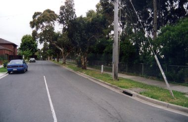
 Whitehorse Historical Society Inc.
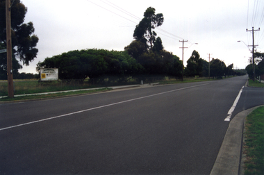
Photograph, Narmara Primary School, 13/01/1994 12:00:00 AM
... Coloured photo of Narmara Primary School, looking West along Highbury Road. School on North side of Highbury Road between Middleborough and Blackburn Roads. ...Whitehorse Historical Society Inc. 2-10 Deep Creek Road Mitcham melbourne narmara primary school warner philip Coloured photo of Narmara Primary School, looking West along Highbury Road. School on North side of Highbury Road between Middleborough and Blackburn Roads. ...Coloured photo of Narmara Primary School, looking West along Highbury Road. School on North side of Highbury Road between Middleborough and Blackburn Roads. Since demolished and site developed for housing.narmara primary school, warner, philip -
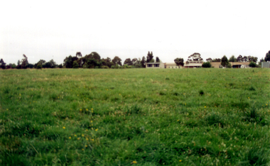
 Whitehorse Historical Society Inc.
Photograph, Narmara Primary School, 13/01/1994 12:00:00 AM
... Coloured photo of Narmara Primary School site looking West along Highbury Road. School on North side of Highbury Road between Middleborough and Blackburn Roads. ...Whitehorse Historical Society Inc. 2-10 Deep Creek Road Mitcham melbourne narmara primary school warner philip Coloured photo of Narmara Primary School site looking West along Highbury Road. School on North side of Highbury Road between Middleborough and Blackburn Roads. ...Coloured photo of Narmara Primary School site looking West along Highbury Road. School on North side of Highbury Road between Middleborough and Blackburn Roads. Since demolished and site developed for housing.narmara primary school, warner, philip -
 Whitehorse Historical Society Inc.
Document, South Riding
... South Boundary Road is now Highbury Road...South Boundary Road is now Highbury Road South Riding Document Document ...Plan showing owners of land in the South Riding of the Shire of NunawadingPlan showing owners of land in the South Riding of the Shire of Nunawading 1888. South Boundary Road is now Highbury RoadPlan showing owners of land in the South Riding of the Shire of Nunawading land subdivision, shire of nunawading. centre riding, dandenong creek, fulton, dr, shire of nunawading. south riding, arundale, w, h. arnold & co. -
Whitehorse Historical Society Inc.
Map, Aerial photograph, c1950
... Aerial photo of Vermont South and Burwood East, Middleborough Road, Burwood Highway, Springvale Road, Highbury Road and environs....Whitehorse Historical Society Inc. 2-10 Deep Creek Road Mitcham melbourne vermont south burwood east aerial photographs Arial photo of Vermont South and Burwood East, Middleborough Road, Burwood Highway, Springvale Road, Highbury Road and environs. Aerial photo of Vermont South and Burwood East, Middleborough Road, Burwood Highway, Springvale Road, Highbury Road and environs. ...Arial photo of Vermont South and Burwood East, Middleborough Road, Burwood Highway, Springvale Road, Highbury Road and environs.Aerial photo of Vermont South and Burwood East, Middleborough Road, Burwood Highway, Springvale Road, Highbury Road and environs.Arial photo of Vermont South and Burwood East, Middleborough Road, Burwood Highway, Springvale Road, Highbury Road and environs.vermont south, burwood east, aerial photographs -
 Whitehorse Historical Society Inc.
Photograph, Whitehorse Historical Society, 2011
... 3 coloured photographs taken at a display of the 150th anniversary of the Burwood East Primary School, corner Blackburn and Highbury Roads, East Burwood....Whitehorse Historical Society Inc. 2-10 Deep Creek Road Mitcham melbourne whitehorse historical society displays 3 coloured photographs taken at a display of the 150th anniversary of the Burwood East Primary School, corner Blackburn and Highbury Roads, East Burwood. Whitehorse Historical Society Photograph Photograph ...3 coloured photographs taken at a display of the 150th anniversary of the Burwood East Primary School, corner Blackburn and Highbury Roads, East Burwood.whitehorse historical society, displays -
Whitehorse Historical Society Inc.
Legal record - Land Title, Certificate of Title, 23/12/1927 12:00:00 AM
... ...Highbury Road Burwood East...Whitehorse Historical Society Inc. 2-10 Deep Creek Road Mitcham melbourne Anderson Thomas Gifford Middleborough Road Burwood East Highbury Road Burwood East 3 Acres 2 roods 8 and 7/10th perches, pt. ...3 Acres 2 roods 8 and 7/10th perches, pt. Crown section 108 Parish of Nunawading, owned by Thomas Gifford Anderson. Vol. 5411 fol. 10820053 Acres 2 roods 8 and 7/10th perches, pt. Crown section 108 Parish of Nunawading, owned by Thomas Gifford Anderson. Vol. 5411 fol. 10820053 Acres 2 roods 8 and 7/10th perches, pt. Crown section 108 Parish of Nunawading, owned by Thomas Gifford Anderson. Vol. 5411 fol. 1082005anderson, thomas gifford, middleborough road burwood east, highbury road burwood east -
 Whitehorse Historical Society Inc.
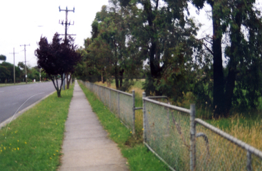
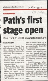
Article, Path's first stage open, 2017
... ...highbury road...Whitehorse Historical Society Inc. 2-10 Deep Creek Road Mitcham melbourne bicycle paths highbury road burwood east ballantyne street melbourne water city of whitehorse Whitehorse Council has opened the first of three stages of the Pipe Track bike path which will eventually link Burwood to Mitcham. ...Whitehorse Council has opened the first of three stages of the Pipe Track bike path which will eventually link Burwood to Mitcham.bicycle paths, highbury road, burwood east, ballantyne street, melbourne water, city of whitehorse -
Whitehorse Historical Society Inc.
Article, Tally Ho
... ...Highbury Road...Whitehorse Historical Society Inc. 2-10 Deep Creek Road Mitcham melbourne Youth Services Tally Ho Boys Home Burwood East Highbury Road Burwood East Springvale Road Burwood East Burwood Road Burwood Tally Ho Youth Services Lingard Ian Three articles about the history and imminent move of Tally Ho Youth Centre. ...Three articles about the history and imminent move of Tally Ho Youth Centre.Three articles about the history and imminent move of Tally Ho Youth Centre.Three articles about the history and imminent move of Tally Ho Youth Centre.youth services, tally ho boys home, burwood east, highbury road, burwood east, springvale road burwood east, burwood road burwood, tally ho youth services, lingard, ian -
 Whitehorse Historical Society Inc.
Photograph, Narmara Primary School, 13/01/1994 12:00:00 AM
... School on North side of Highbury Road, between Middleborough Road and Blackburn Road. ...School on North side of Highbury Road, between Middleborough Road and Blackburn Road. ...Coloured photo of Narmara Primary School, Namara Street, looking North. School on North side of Highbury Road, between Middleborough Road and Blackburn Road. Since demolished and site developed for housing.narmara primary school, warner, philip -
Whitehorse Historical Society Inc.
Map, City of Whitehorse, 1/03/1995 12:00:00 AM
... Map showing streets of the City of Whitehorse from Mullum Mullum Creek to the north to Highbury Road and Warrigal Road in the west, to Heatherdale Road in the east. ...Map showing streets of the City of Whitehorse from Mullum Mullum Creek to the north to Highbury Road and Warrigal Road in the west, to Heatherdale Road in the east. ...Map showing streets of the City of Whitehorse from Mullum Mullum Creek to the north to Highbury Road and Warrigal Road in the west, to Heatherdale Road in the east.Map showing streets of the City of Whitehorse from Mullum Mullum Creek to the north to Highbury Road and Warrigal Road in the west, to Heatherdale Road in the east. Prep. by Richard Meloni. Scale 1:15,000Map showing streets of the City of Whitehorse from Mullum Mullum Creek to the north to Highbury Road and Warrigal Road in the west, to Heatherdale Road in the east. city of whitehorse, mullum mullum creek -
 Whitehorse Historical Society Inc.
Photograph - ColouredPhotograph, Narmara Primary School, 13/01/1994 12:00:00 AM
... School on North side of Highbury Road between Middleborough Road and Blackburn Road. ...School on North side of Highbury Road between Middleborough Road and Blackburn Road. ...Coloured photo of Narmara Primary School, looking North from south boundary. School on North side of Highbury Road between Middleborough Road and Blackburn Road. Since demolished and site developed for housing.narmara primary school, warner, philip -
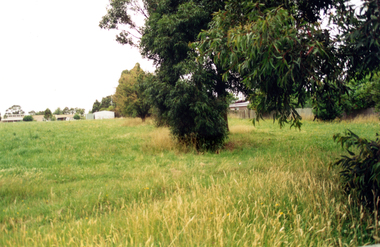 Whitehorse Historical Society Inc.
Photograph, Narmara Primary School, 13/01/1994 12:00:00 AM
... School on North side of Highbury Road between Middleborough Road and Blackburn Road. ...School on North side of Highbury Road between Middleborough Road and Blackburn Road. ...Coloured photo of Narmara Primary School looking North along East boundary. School on North side of Highbury Road between Middleborough Road and Blackburn Road. Since demolished and site developed for housing.narmara primary school, warner, philip