Showing 2361 items matching highway
-
 Buninyong & District Historical Society
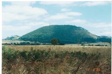
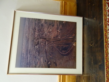
Photograph - Original Photograph, Ann Beggs-Sunter, Mount Buninyong from Midland Highway at Scotsburn, 1996, November 1995
historic transportColour photo, Mount Buninyong from Midland Highway at Scotsburn, 1996mount buninyong -
 Ringwood and District Historical Society
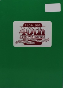
Book, 40th Anniversary - Ringwood Secondary College, Ringwood High School, 1954-1994, 1994
Soft covered booklet of photographs and recollections over four decades 1954-1994. -
 Kew Historical Society Inc
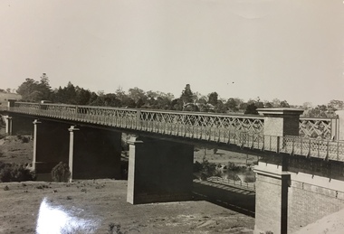
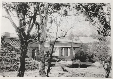
Photograph, Outer Circle Railway Viaduct, 1919
Railway Viaduct constructed for the Outer Circle Railway. Bridge designed by John Monash, engineer. Converted into a state highway, 1930s.Dateable photo of an important piece of Victorian railway infrastructure.Photograph of Outer Circle Railway Bridge over River Yarra, Fairfield. Looking toward Lugton Street, showing fence underneath taken from the Chandler Highway. Reverse: "Outer Circle Railway Bridge over River Yarra Fairfield, H0276, Property of Miss Foley"railway viaduct, chandler highway -
 Ringwood and District Historical Society
Photograph, "Why Ringbark Ringwood" sign Maroondah Highway view near Heatherdale Road. (undated)
"Why Ringbark Ringwood" sign Maroondah Highway view near Heatherdale Road. -
 Brimbank City Council
Framed Colour Photograph, View of the city and highway from western suburbs 1985
Framed Colour Photograph - View of the city and highway from western suburbs 1985 -
 Whitehorse Historical Society Inc.
Article, The Maroondah Highway - past, present and future, 1/10/1970 12:00:00 AM
Supplement to C.R.B. News, 1970 giving detailed history and description of the Maroondah Highway.Supplement to C.R.B. News, 1970 giving detailed history and description of the Maroondah Highway.Supplement to C.R.B. News, 1970 giving detailed history and description of the Maroondah Highway.maroondah highway, whitehorse road, victoria. country roads board -
Whitehorse Historical Society Inc.
Newspaper, Along the highway, 1992
A guide to business along the Maroondah Highway from Middleborough Road to Heatherdale Road.A guide to business along the Maroondah Highway from Middleborough Road to Heatherdale Road.A guide to business along the Maroondah Highway from Middleborough Road to Heatherdale Road.maroondah highway blackburn, pharmacies, maroondah highway mitcham, athan, savvas, maroondah highway nunawading, gelb, joe, mitcham shopping centre, regal kitchens, blackburn, nunawading fire station, armstrong, norman -
 Ringwood and District Historical Society
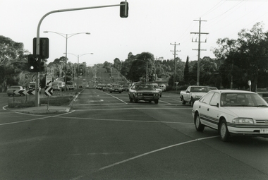
Photograph, Maroondah Highway, Ringwood, looking east from Oban Road - 1999
Looking East along Maroondah Highway, near the corner of Oban Road in December 1999 -
 Ringwood and District Historical Society
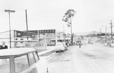
Photograph, Maroondah Highway roadworks outside Bill Patterson Motors. ca 1958?
Maroondah Highway roadworks outside Bill Patterson Motors. No date, possibly around 1958. -
 Ringwood and District Historical Society
Photograph, Maroondah Highway roadworks outside Bill Paterson Motors. ca 1960?
Maroondah Highway roadworks outside Bill Paterson Motors. No date, possibly around 1960. -
 Ringwood and District Historical Society
Photograph, Construction of shops and offices to let, Maroondah Highway next to the Ringwood Drive In Shopping Centre. (Undated)
Construction of shops and offices to let, Maroondah Highway next to the Ringwood Drive In Shopping Centre.Stamp on back of photograph reads, "John Gallagher - photographer" -
 Mt Dandenong & District Historical Society Inc.
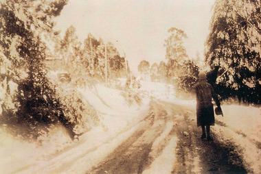
Photograph, Miss Perriman on Main Highway, Kalorama 1931, c1930
Back view of Miss Perriman walking along the Main Highway, Kalorama, in the snow in 1931.kalorama, snow, main highway, perriman -
Whitehorse Historical Society Inc.
Map, Burwood Highway, c1970
Enlarged aerial photo of area South of Burwood Highway to Dandenong Creek, Vermont South.Enlarged aerial photo of area South of Burwood Highway to Dandenong Creek, Vermont South.Enlarged aerial photo of area South of Burwood Highway to Dandenong Creek, Vermont South.dandenong creek, morack road, vermont south, burwood highway, vermont south, aerial photographs -
 Lorne Historical Society
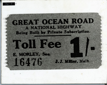
Photograph, G.O.R National Highway Private Subscription Toll fee ticket
Photograph National Highway private subscription toll fee for the G.O.R. Cost 1/- (one shilling)toll-fee: toll-ticket; g.o.r -
 Ringwood and District Historical Society
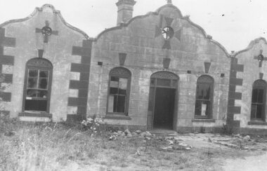
Photograph, The Rest" tea rooms, Maroondah Highway, opposite Heatherdale Road
Black and white photograph of old brick building with scalloped roof-line. Decorative bricks in various places, particularly on top of windows and door.'The Rest' tea rooms, Maroondah Highway, opposite Heatherdale Road. -
![Photographs [Series], Noel Kelly, Chandler Highway Bridge Construction, 11/07/2018](https://victoriancollections.net.au/media/collectors/550653872162f11fb04854aa/items/5c2f52bd21ea670d20783d9e/item-media/5c2f53b221ea670d2079233e/item-fit-380x285.jpg) Kew Historical Society Inc
Kew Historical Society IncPhotographs [Series], Noel Kelly, Chandler Highway Bridge Construction, 11/07/2018
A selection of photographs taken in July/August 2018 recording work on the old and new Chandler Highway Bridges.chandler highway bridge, noel kelly, railway viaduct - river yarra -
 Kew Historical Society Inc
Photograph, Chandler Highway Bridge, 1930s
The railway viaduct linking the Outer Circle railway from Kew to Fairfield was constructed in the 1890s. In the 1930s it was converted into a motorway bridge.Photocopy of a photograph of the bridge linking Kew and Fairfield. Dated to the 1930s following the construction off the Chanler Highway.outer circle railway, viaduct (kew fairfield), john monash, chandler highway bridge -
 Melbourne Tram Museum
Letter, Australian Electric Traction Association (AETA), "Proposal to build a tramline down Nepean Highway to Southland", May. 1977
Letter with supplementary document - "Proposal to build a tramline down Nepean Highway to Southland", advocating residents support a study into a possible tram line to Southland, May 1977. The Nepean Highway was being widened at the time. Produced by the AETA. Printed by duplicating process on white foolscap paper.trams, tramways, public transport, mmtb, proposals, moorabbin -
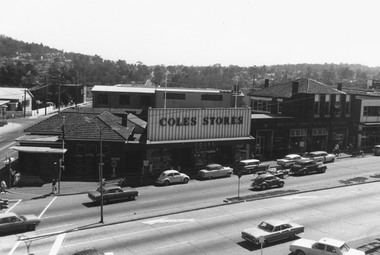 Ringwood and District Historical Society
Photograph, Clocktower view overlooking Ringwood Street, Post Office, Coles Store and State Savings Bank, Maroondah Highway, Ringwood - 1969
Written below photograph, "Maroondah Highway 1969 showing old Post Office" Written on backing sheet, "Dec. 1969. Maroondah Highway, post office, Coles, S.S.B." -
![Photographs [Series], Noel Kelly, Chandler Highway Bridge Construction, August 2018, 07/08/2018](https://victoriancollections.net.au/media/collectors/550653872162f11fb04854aa/items/5c2f545421ea670d20799ebb/item-media/5c2f54c721ea670d207a1d1c/item-fit-380x285.jpg) Kew Historical Society Inc
Kew Historical Society IncPhotographs [Series], Noel Kelly, Chandler Highway Bridge Construction, August 2018, 07/08/2018
The second of a series of photographs taken in July/August 2018 recording work on the old and new Chandler Highway Bridges.chandler highway bridge -
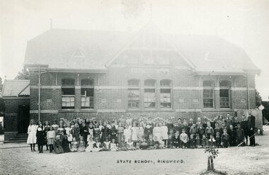 Ringwood and District Historical Society
Photograph, Ringwood State School- Maroondah Highway. c1908
Black and white photograph.SS No 2997- Maroondah Highway Mr H.T.Hocking-Headmaster on right. c1908 -
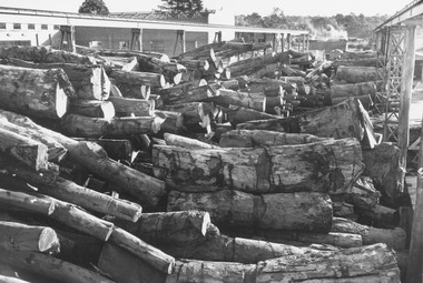 Ringwood and District Historical Society
Photograph, Ringwood Timber and Trading, Maroondah Highway. (undated, probably late 1960's early 1970's)
Unmilled Timber yardWritten on back of photograph, "Ringwood Timber and Trading, Maroondah Highway". Undated -
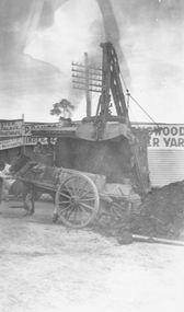 Ringwood and District Historical Society
Photograph, Roadworks on Maroondah Highway at corner Warrandyte Rd
Black and white photograph of horse and wagon. Scoop dumping soil into wagon.Typed below photograph, "Roadworks on Maroondah Highway at corner Warrandyte Rd." -
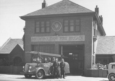 Ringwood and District Historical Society
Photograph, Ringwood Fire Station, Maroondah Highway, 1960
Written on back of photograph, "Ringwood Fire Station, Maroondah Highway, 1960." -
 Ringwood and District Historical Society
Photograph-B&W, Joan Walker, East Ringwood 2000-Burnt Bridge Shopping Centre, Maroondah Highway, 2000
East Ringwood 2000-Burnt Bridge Shopping Centre, Maroondah Highway- B&W Photo from Album 6501 -
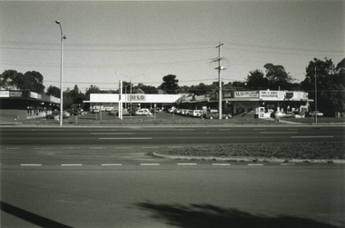
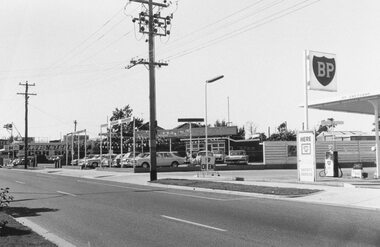 Ringwood and District Historical Society
Photograph, Maroondah Highway businesses, south side between no.84 and BP Service Station.1969
Written on backing sheet, "May, 1969". Maroondah Highway businesses, south side between no.84 and BP Service Station.Written on backing sheet, "May, 1969". -
 Ringwood and District Historical Society
Photograph, Rear of building at no.85 Maroondah Highway, Ringwood. Later Honda. 1981
Building became Honda. 85 Maroondah HwyWritten on back of photograph, "1981. Rear of building at no.?? Maroondah Highway". Later Honda -
 Ringwood and District Historical Society
Photograph, Maroondah Highway, Ringwood, viewed from Warrandyte Road towards Eastland - 1974. Bus and taxi access road to railway station on left
Written on backing sheet, "Maroondah Highway near corner Warrandyte Rd., 1974". -
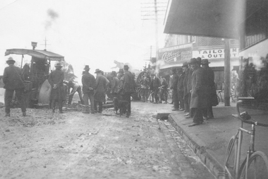 Ringwood and District Historical Society
Photograph, Bogged on Maroondah Highway
Black and white photograph of work on roadway. Bogged equipment with men standing looking on.Typed below photograph, "Bogged on Maroondah Highway opposite station. Circa 1930". -
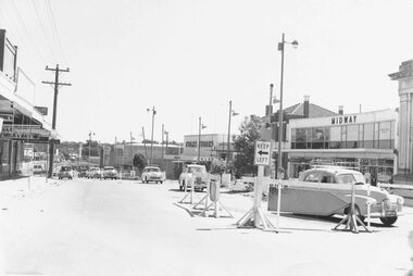 Ringwood and District Historical Society
Photograph, Maroondah Highway, Ringwood, west of Railway Station entrance - 1960
Written on back of photograph, "Maroondah Highway west from entrance to Station - 1960".