
Showing 10 items matching "historical mining construction"
-
 The Beechworth Burke Museum
Photograph, 1920-1950
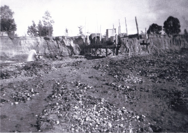
... ...historical mining construction...This photograph has historic and research potential for understanding changes to the landscape, the evolution of mining methods, and the extensive construction, manipulation and management of water networks in the Beechworth district. burke museum beechworth museum beechworth gold fields gold rush victorian gold rush hydraulic sluicing spring creek netwown falls mining tunnels water races tailraces gold ming history colonial australia australian gold rushes mining technology beechworth historic district indigo gold trail indigo shire john pund water manipulation water engineering three mile creek three mile mine water race large-scale mining methods historical mining construction alluvial mining mining environmental impacts baarmutha water barons Reverse: 7597-1 / Sluice Mining / Copied from original on loan from Webb (Qld) / Donated Nov 2009 / Baarmutha Three Mile Mine c1920-1950 / Managed by the Plain Bros then Parkinsons / Current Location is: Beechworth Animal Shelter / used for Baarmutha Black and white rectangular photograph on matte paper Photograph Photograph ...This image taken between 1920-1930 depicts open-cut hydraulic sluicing at the Three Mile Mine, located about five kilometres south of Beechworth. Alluvial, or surface, mining began on this site in the 1850s, but was soon replaced by hydraulic sluicing methods. By the start of 1880 it is estimated that nine hundred miles of water races had been cut though soil and rock in the Beechworth district. Hydraulic sluicing employs high pressure jets of water to blast away large areas of earth and wash it down to be run through a sluice box. Gold gets caught in the sluice and the remaining slurry is washed away. Large water quantities were required for hydraulic sluicing, and the long water races and deep tailraces that were constructed were considered great engineering feats. This method of mining is extremely effective, but causes significant environmental damage and impacts to waterways and agricultural operations. Miners at Beechworth built extensive networks of races and dams to secure reliable supplies of water on a scale far greater than elsewhere in Victoria. By the 1880s Beechworth's water barons continued to hold more than half of all the water right licences on issue and undertook sluicing operations on a massive scale. The manipulation of surface and ground water via race networks was well planned and recorded in detail by local mining surveyors. The maps that were created, combined with modern geo-spatial technologies, provide a vital key in understanding the great lengths to which miners went to capture and control critical water resources. Today, Three Mile mine is called Baarmutha. The Three Mile Mine was unproductive until 1865 when John Pund and three other miners secured a fifteen year license and constructed a water race from Upper Nine Mile Creek to Three Mile Creek. In the early twentieth century Pund & Co. averaged over one thousand ounces of gold per year from the mine. After Pund's death in 1915, GSG Amalgamated Co operated the site, continuing sluicing until 1950. This image of hydraulic sluicing methods shows the extent of water-works engineering in the landscape. This photograph has historic and research potential for understanding changes to the landscape, the evolution of mining methods, and the extensive construction, manipulation and management of water networks in the Beechworth district. Black and white rectangular photograph on matte paperReverse: 7597-1 / Sluice Mining / Copied from original on loan from Webb (Qld) / Donated Nov 2009 / Baarmutha Three Mile Mine c1920-1950 / Managed by the Plain Bros then Parkinsons / Current Location is: Beechworth Animal Shelter / used for Baarmuthaburke museum, beechworth museum, beechworth, gold fields, gold rush, victorian gold rush, hydraulic sluicing, spring creek, netwown falls, mining tunnels, water races, tailraces, gold ming history, colonial australia, australian gold rushes, mining technology, beechworth historic district, indigo gold trail, indigo shire, john pund, water manipulation, water engineering, three mile creek, three mile mine, water race, large-scale mining methods, historical mining construction, alluvial mining, mining environmental impacts, baarmutha, water barons -
 The Beechworth Burke Museum
Geological specimen - Cerussite, Unknown c.1890s
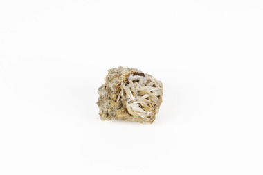
... Historically, it has been an important source of lead, which has numerous industrial applications, including in batteries, construction materials, and radiation shielding. Cerussite has a crystal structure that belongs to the orthorhombic crystal system. Its crystal structure is characterized by a three-dimensional arrangement of atoms in a repeating pattern. The crystal lattice of cerussite consists of interconnected lead (Pb) and carbonate (CO3) ions. This crystal structure is visible in the specimen. This specimen was found in Dundas (formerly Mount Dundas), a historical mining...Historically, it has been an important source of lead, which has numerous industrial applications, including in batteries, construction materials, and radiation shielding. Cerussite has a crystal structure that belongs to the orthorhombic crystal system. Its crystal structure is characterized by a three-dimensional arrangement of atoms in a repeating pattern. The crystal lattice of cerussite consists of interconnected lead (Pb) and carbonate (CO3) ions. This crystal structure is visible in the specimen. This specimen was found in Dundas (formerly Mount Dundas), a historical mining ...Named in 1845 by Wilhelm Karl von Haidinger cerussite takes its name from the Latin cerussa, meaning 'white lead'. When viewed under certain lighting conditions cerussite gives of fire and rainbow-like colours (due to its high dispersion) and it is quite sought after by geological collectors for this very reason. Cerussite is usually found in the oxidised zone of lead ore deposits. It is a very common weathering product of galena and other lead ore minerals. It is a secondary mineral, meaning it forms as a result of the alteration of pre-existing minerals in the Earth’s crust. The presence of lead in cerussite makes it potentially toxic. Historically, it has been an important source of lead, which has numerous industrial applications, including in batteries, construction materials, and radiation shielding. Cerussite has a crystal structure that belongs to the orthorhombic crystal system. Its crystal structure is characterized by a three-dimensional arrangement of atoms in a repeating pattern. The crystal lattice of cerussite consists of interconnected lead (Pb) and carbonate (CO3) ions. This crystal structure is visible in the specimen. This specimen was found in Dundas (formerly Mount Dundas), a historical mining locality, mineral field and railway located on the western foothills of the West Coast Range in Western Tasmania. During the 1890s Dundas swelled in numbers however it is now lost in a temperate rainforest and its population is now 2. The present Dundas Extended mine, about 1.5 km east of Dundas is presently worked for specimen material.Faceted cerussite gems are considered rare and valuable, given the softness of the mineral. This item is not a faceted gem however its historical and scientific research potential give it significance; mined in an Australian township, this cerussite could shed light on the now lost history of Dundas and the mining that occurred there. Additionally, the uses of this mineral in historical industrial processes give it scientific significance. Such knowledge can add to understandings of the geographical and geological nature of Western Tasmania and allow for further study of Australian geological specimens. A small lead carbonite mineral with shades of cream, white and brown throughout, flaky shards of white at base. CERUSSITE / (lead carbonite) / Locality: Dundas, W. Tasmaniadundas, tasmania, cerussite, lead, orthorhombic, geology, minerals, mining -
 The Beechworth Burke Museum
Photograph - Stereoscopic Photograph, Unknown c1875
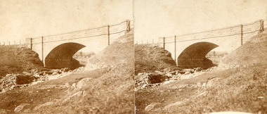
... mining activity in the area and the rapid increase in Australia's economy that led to investment and development of roads and railways. The local granite used in the construction of the single arch Newtown Bridge makes the bridge and other buildings made with the granite unique to the area, the honey-toned material distinct to Beechworth. This photograph is historically ...Depicted in the photograph is Newtown Bridge or the Newtown Falls Bridge, in Beechworth, Victoria. Noted for its location, detailed craftsmanship and stonemasonry by Scottish stonemasons the Newtown Bridge was built in the 19th century provincial town of Beechworth (completed in 1875). The bridge was built over Spring Creek, spanning 6.3 meters wide and 24.8 meters tall. Beechworth held a distinct role in the administrative and commercial management of Victoria's north-eastern goldfields, with many objects and structures still well preserved from the towns establishment. The bridge indicates the growth of the town, replacing a previous timber structure as well as its association to the mining activity in the area and the rapid increase in Australia's economy that led to investment and development of roads and railways. The local granite used in the construction of the single arch Newtown Bridge makes the bridge and other buildings made with the granite unique to the area, the honey-toned material distinct to Beechworth. This photograph is historically significant as it provides insight into the industrial development of Beechworth and the surrounding area, contributed to by the goldfields. The photograph further captures the representation of vernacular engineering traditions and Scottish stonemasonry.Two sepia-toned rectangular photographs featuring a bridge in the background printed on matte photographic paper mounted on card.Reverse: 97.2324/ Newtown Bridge/ Beechworthbridge, newtown beechworth, newtown bridge, newtown, beechworth, beechworth falls bridge, beechworth mining district, spring creek, -
 Bendigo Historical Society Inc.
Photograph - Kangaroo Flat Gold Mine Collection: underground in Swan Decline, Kangaroo Flat Gold Mine, 2000
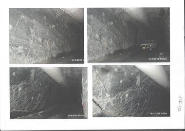
... mining, was permanently closed in December 2022. Important parts of Bendigo’s gold rush history were also preserved from the onsite office buildings with 19 boxes of records, and 1350 old photos being scanned and provided to the local historical societies and the Goldfields Library Corporation. A volunteer from the Bendigo Historical Society, Kay MacGregor, also scanned approximately 40 bookshelves of newspaper clippings to assist with recording and preserving geological drilling locations. goldmining Kangaroo Flat Gold Mine Western Mining Corporation Unity Mining Swan Decline Black and white photocopies of photographs of Swan Decline, showing some stages of underground construction. ...The modern mine is accessed via the Swan Decline, which commences at the Kangaroo Flat site on the southern outskirts of Bendigo and progresses in a north easterly direction between the Deborah and Sheepshead anticlines, reaching a depth of almost 1000 m below the City of Bendigo. Development of this decline commenced in 1998. Swan Decline closed and history preserved In a major rehabilitation milestone at Kangaroo Flat, the Swan Decline Bendigo’s primary gateway to underground mining, was permanently closed in December 2022. Important parts of Bendigo’s gold rush history were also preserved from the onsite office buildings with 19 boxes of records, and 1350 old photos being scanned and provided to the local historical societies and the Goldfields Library Corporation. A volunteer from the Bendigo Historical Society, Kay MacGregor, also scanned approximately 40 bookshelves of newspaper clippings to assist with recording and preserving geological drilling locations.Black and white photocopies of photographs of Swan Decline, showing some stages of underground construction. Eleven images on 3 pages, dated 16/4/2000 (10 a.m.) show decline walls, rock bolts and markout of tunnel shape. One image shows a utility in the tunnel. Final three images on one page, have notations on the photos: 'opposite SP18 LHS decline', 'just up from previous 3 box positions' and 'just up from tank, same side' On bottom RH side 'spots for scale attention, IT required, all lower decline.' All three images dated 12/6/2000.goldmining, kangaroo flat gold mine, western mining corporation, unity mining, swan decline -
 Bendigo Historical Society Inc.
Newspaper - LONG GULLY HISTORY GROUP COLLECTION: LONG GULLY, 1976
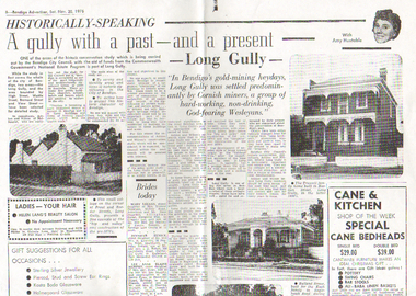
... Historically Speaking A gully with a past - and a present - Long Gully with Amy Huxtable. Mentioned is a study carried out by the consultants Ashton and Wilson, the people who settled in the areas and the houses and miners' cottages. Photos include a miners cottage with a hip and valley roof construction, the Truscott Family home, Rutland House, built for the Koch Family during the quartz era of Bendigo's mining days is now Crusade House, a timber miner's cottage with a kangaroo roof construction and a cottage in William Street. ...Historically Speaking A gully with a past - and a present - Long Gully with Amy Huxtable. Mentioned is a study carried out by the consultants Ashton and Wilson, the people who settled in the areas and the houses and miners' cottages. Photos include a miners cottage with a hip and valley roof construction, the Truscott Family home, Rutland House, built for the Koch Family during the quartz era of Bendigo's mining days is now Crusade House, a timber miner's cottage with a kangaroo roof construction and a cottage in William Street. ...BHS CollectionCopy of a Bendigo Advertiser 20/11/1976 article titled Historically Speaking A gully with a past - and a present - Long Gully with Amy Huxtable. Mentioned is a study carried out by the consultants Ashton and Wilson, the people who settled in the areas and the houses and miners' cottages. Photos include a miners cottage with a hip and valley roof construction, the Truscott Family home, Rutland House, built for the Koch Family during the quartz era of Bendigo's mining days is now Crusade House, a timber miner's cottage with a kangaroo roof construction and a cottage in William Street. There are also advertisements from various businesses on the page.bendigo, history, long gully history group, the long gully history group - long gully, bendigo advertiser 20/11/1976, amy huxtable, bendigo city council, commonwealth government's national estate program, ashton and wilson, henry koch, truscott family, rutland house, hip and valley roof construction, kangaroo roof construction, vahland villa, helen lang's beauty salon, cane & kitchen, bazulas, myer, kangaroo flat newsagewncy, margaret kean, corrigan's pharmacy, w p bissett, rob vains, golden hills motel, gale's carpet steam cleaners, ray gale, dungey's bendigo travel service -
 Puffing Billy Railway
Explosives Wagon, unkown
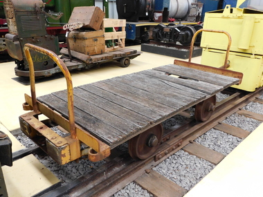
... mining services operations • quarry services • other chemical manufacture activities. The Deer Park factory complex The factory complex is of historical significance for the major role it played in Australia's manufacturing and mining industries through the development of progressively more efficient and safer explosives. It also contributed to wartime production in ammunition, initiators and the development of synthetic ammonia production and construction...mining services operations • quarry services • other chemical manufacture activities. The Deer Park factory complex The factory complex is of historical significance for the major role it played in Australia's manufacturing and mining industries through the development of progressively more efficient and safer explosives. It also contributed to wartime production in ammunition, initiators and the development of synthetic ammonia production and construction ...This 2 foot 6 inch (762mm) gauge wagon was used for carrying explosives and was used with the Greenbat Battery loco. It was donated to the Walhalla Goldfields Railway on long term loan in 2013 along with a large quantity of narrow gauge trollies and light rail from Orica’s now closed munitions factory in Melbourne’s western suburbs. Orica - Deer Park Munitions factory Orica Deer Park in Melbourne’s west has been used since circa 1875 for various forms of manufacturing and storage of chemicals. Although the site is bounded by Ballarat Road, Station Street, Tilburn Road and the Western Ring Road, the current entry point for industrial operations is situated at Gate 6 of Tilburn Road. Operations include: • a specialty chemicals facility producing products for mining services operations • quarry services • other chemical manufacture activities. The Deer Park factory complex The factory complex is of historical significance for the major role it played in Australia's manufacturing and mining industries through the development of progressively more efficient and safer explosives. It also contributed to wartime production in ammunition, initiators and the development of synthetic ammonia production and construction of the Defence Explosives Annexe No 5 (later the Albion Explosives Factory) during World War Two. The factory complex is also of technical significance for the unusual and specialised design of many of the buildings and structures, both in the layout of the works and the individual design of buildings. Blast protection and safety measures such as mounds around the buildings, 'cleanways' and buffer zones between production areas were employed extensively. A characteristic of many production buildings was the elimination of cavities where explosive compounds could lodge. The combination of concrete barriers and light-weight construction was designed to direct explosion debris away from operators or other buildings. The narrow gauge tramway, which ran through the explosives section, is a rare survivor of nineteenth century materials-handling methods. Historic - Industrial Narrow Gauge Railway - Wagon for carrying Explosives at the Orica - Deer Park Munitions factory, Deer park, Victoria, Australia Wagon for carrying explosives made from Timber and steelwagon for carrying explosives, puffing billy, industrial narrow gauge railway, orica - deer park munitions factory, explosives wagon -
 Ballarat Heritage Services
Photograph - Photograph - Colour, Clare Gervasoni, Nimon's Bridge, 1999, 04/10/1999
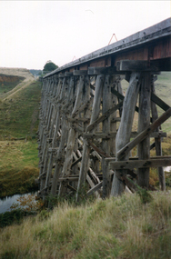
... Nimons Bridge is historically significant as having served initially the mining community at Linton, then the Western District agricultural area and in later years a kaolin quarry at Pittong. Nimons Bridge is historically significant as a representative of the 'light' branch line methodology that stimulated the explosion of railway construction in Victoria during the 1880s, and provides an interesting contrast with the more solid and vastly more expensive railway viaducts built in similar terrain on Victorian main lines, at Moorabool and Taradale, in the late 1850s. ...Nimons Bridge is historically significant as having served initially the mining community at Linton, then the Western District agricultural area and in later years a kaolin quarry at Pittong. Nimons Bridge is historically significant as a representative of the 'light' branch line methodology that stimulated the explosion of railway construction in Victoria during the 1880s, and provides an interesting contrast with the more solid and vastly more expensive railway viaducts built in similar terrain on Victorian main lines, at Moorabool and Taradale, in the late 1850s. ...Nimons Bridge was built in 1890, as part of the then Ballarat-Linton railway. The bridge is 17 spans with tall timber piers of four driven piles each, with triple sets of diagonal cross-bracing and walers and a single row of longitudinal horizontal bracing between piers. The spans are of a uniform twenty feet (6.1 metres), originally supported by four 21-inch x 9-inch (535 mm x 230 mm) Kauri timber beams per span, following the standard V.R. design of the period. When the superstructure was rebuilt after the 1953 fire, the timber beams were replaced with two 24-inch (610mm) deep rolled-steel-joists on each span. These are marked 'Lancashire Steel Co., Scotland' and are believed to have been second-hand. The deck of transverse-timber planks is 103.6 metres in length. Overall the bridge has an impressive appearance with its exceptionally tall triple-cross-braced piers creating a 'three-tiered' effect, with the deck 19.2 metres above the Woady Yaloak River. The Ballarat-Skipton line closed in 1985. Nimons Bridge has been recently restored, as part of the Ballarat-Skipton Rail Trail. How is it significant? Nimons Bridge is significant for technical, historic and aesthetic reasons at a State level. Why is it significant? Nimons Bridge is technically significant as Victoria's fourth-tallest timber trestle bridge when built, and as the third-tallest surviving example. It is also the second-largest composite bridge combining traditional timber piers with RSJ spans and a timber deck and falls within a select group of fewer than ten timber railway bridges with horizontal longitudinal bracing between the piers and three sets of double cross-bracing on its tallest piers, creating a visually striking 'three tiered' effect that enhances its viaduct form. Nimons Bridge is historically significant as having served initially the mining community at Linton, then the Western District agricultural area and in later years a kaolin quarry at Pittong. Nimons Bridge is historically significant as a representative of the 'light' branch line methodology that stimulated the explosion of railway construction in Victoria during the 1880s, and provides an interesting contrast with the more solid and vastly more expensive railway viaducts built in similar terrain on Victorian main lines, at Moorabool and Taradale, in the late 1850s. Approached by a deep cutting and high embankment at either end, the bridge represents a very cost-effective late 19th century engineering solution to the characteristic physiography of western Victoria with flat basalt plains intersected by deep wide valleys occasionally subject to severe flooding. Nimons Bridge is aesthetically significant for its visually impressive viaduct form, crossing a deep and steep-sided valley that is part of a rich cultural landscape. Within close proximity of the bridge are mullock dumps, tailings, shaft sites and other relics of the deep-lead alluvial mining era. The bridge is the most visually spectacular timber-trestle rail bridge in Western Victoria and is among the most spectacular timber-trestle rail bridges surviving anywhere in Victoria. It is part of the Ballarat-Skipton Rail Trail. Classified by the National Trust :02/10/2000 (http://vhd.heritagecouncil.vic.gov.au/places/67986)Colour photograph of a log bridge known as Nimon's Bridge.ballarat-linton, nimons bridge, nimon's bridge, log bridge, viaduct, timber-trestle rail bridge -
 Wodonga & District Historical Society Inc
Photograph - Codling Collection 01 - Wodonga Powder Magazine
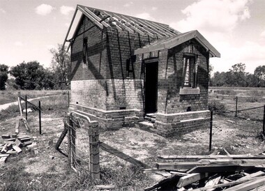
... Historical Society. Many of her prize-winning photos are held in the Society Collection. She also held a range of roles and committee positions in a wide range of Wodonga community organisations. THE WODONGA POWDER MAGAZINE was built by Edward Hope in 1877-78 to the order of the Ministry of Trade and Customs. It was built of brick and contains a brick arched ceiling vault to absorb any explosion The Wodonga Powder Magazine stored explosives for use in deep lead gold mining and public works in the district. The original construction...Historical Society. Many of her prize-winning photos are held in the Society Collection. She also held a range of roles and committee positions in a wide range of Wodonga community organisations. THE WODONGA POWDER MAGAZINE was built by Edward Hope in 1877-78 to the order of the Ministry of Trade and Customs. It was built of brick and contains a brick arched ceiling vault to absorb any explosion The Wodonga Powder Magazine stored explosives for use in deep lead gold mining and public works in the district. The original construction ...Miss Olive Codling was a Foundation Member and a Life Member of the Wodonga Historical Society. Many of her prize-winning photos are held in the Society Collection. She also held a range of roles and committee positions in a wide range of Wodonga community organisations. THE WODONGA POWDER MAGAZINE was built by Edward Hope in 1877-78 to the order of the Ministry of Trade and Customs. It was built of brick and contains a brick arched ceiling vault to absorb any explosion The Wodonga Powder Magazine stored explosives for use in deep lead gold mining and public works in the district. The original construction cost £330.05.6. In 1993, at a cost of $27,000, Wodonga City Council employed Anton Iskra to carry out restoration of the Powder Magazine.This photo collection is significant as it documents a building which played a significant role in Wodonga and has a local heritage overlay.Black and white images of the ruins of the Wodonga Powder Magazine.wodonga powder magazine, gateway island wodonga, historic buildings wodonga -
 The Beechworth Burke Museum
Photograph - Photograph - Reproduction
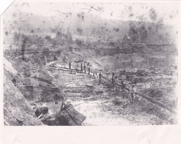
... Mining District. As suggested by the numerous figures involved in labouring along the water race, sluicing was a source of considerable employment within the region. This image is of important historical significance for its ability to convey information about sluicing and the methods used to find gold in the 1850s, and provides clues as to how sluicing and the widespread construction of water ranges changed the environment of the region. ...This photograph depicts mining operations within the Beechworth area, in an unidentified valley where sluicing was utilised as a method for extracting gold from the environment. After gold was discovered in the region in 1851, sluicing became a characteristic of gold mining in the region - "Ovens miners carved intricate networks of races" throughout the region - involved the diversion of water in many channels, or water races, which contained inbuilt 'ripple devices' designed to trap gold for later extraction. By 1871, 900 miles of water races had been cut into the Beechworth Mining District. As suggested by the numerous figures involved in labouring along the water race, sluicing was a source of considerable employment within the region. This image is of important historical significance for its ability to convey information about sluicing and the methods used to find gold in the 1850s, and provides clues as to how sluicing and the widespread construction of water ranges changed the environment of the region. This image is important for current research into the history of the Ovens region in Victoria, which played such a prominent role in the early Australian gold mining industry. Therefore, this image has the capacity to be beneficial for research into society and the motivations of those living and working in this region during this period and therefore, has social significance. The Beechworth Burke Museum has additional images relating to gold sluicing and and the mining activities in the area more generally, which can be analysed and studied alongside images like this one.A black and white rectangular photograph printed on matte photographic paperbeechworth, mining, miners, labour, water race, sluicing -
 Sunshine and District Historical Society Incorporated
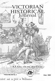
Journal - Victorian Historical Journal Volume 80 Number 1 June 2009, Royal Historical Society of Victoria, June 2009
... historical studies and book reviews. The articles in this volume range in time from the spread of white settlement into the countryside to the construction of Victoria's second university. Monash University Gold Mining ...The Victorian Historical Journal, first published as the Victorian Historical Magazine in 1911, is the official journal of record and scholarly publication of the Royal Historical Society of Victoria. It is the second oldest history journal in Australia. It has become a vast collaborative history of Victoria with hundreds of individual contributors and topics and has itself become a primary source for researchers.Paperback book with glossy front covernon-fictionThe Victorian Historical Journal, first published as the Victorian Historical Magazine in 1911, is the official journal of record and scholarly publication of the Royal Historical Society of Victoria. It is the second oldest history journal in Australia. It has become a vast collaborative history of Victoria with hundreds of individual contributors and topics and has itself become a primary source for researchers. monash university, gold mining, squatters, australian rules football, sport and racing in melbourne, welsh in victoria, victorian landscapes
