Showing 74 items matching "history bendigo mines locations"
-
 Bendigo Historical Society Inc.
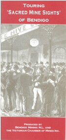
Book - TOURING 'SACRED MINE SIGHTS' OF BENDIGO, c1994
... ...history Bendigo mines locations...Bendigo Historical Society Inc. History House 11 Mackenzie Street Bendigo goldfields BENDIGO Mining mining history guide for toursts history Bendigo mines locations David G Horsfall Touring 'Sacred Mine Sights' of Bendigo. ...Touring 'Sacred Mine Sights' of Bendigo. Gold was discovered in 1851 and the mining era continued until 1954. Produced by Bendigo Mining NL and The Victorian Chamber of Mines Inc. Place of publication: Bendigo. 16 pages. Maps.David G Horsfallbendigo, mining, mining history guide for toursts, history bendigo mines locations -
 Bendigo Historical Society Inc.
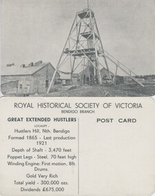
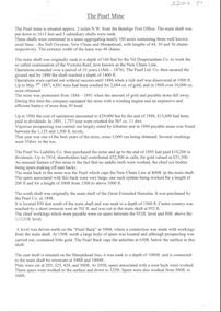
Photograph - GREAT EXTENDED HUSTLERS (POSTCARD)
... Great Extended Hustlers (Postcard series of the Royal Historical Society of Victoria (Bendigo Branch). 8 identical cards. Summary history of mine on reverse, LH side: Location, depth, poppet and engine detail, gold yield, dividends. ...Bendigo Historical Society Inc. History House 11 Mackenzie Street Bendigo goldfields PLACE Mining site great extended hustler quartz mine Great Extended Hustlers (Postcard series of the Royal Historical Society of Victoria (Bendigo Branch). 8 identical cards. Summary history of mine on reverse, LH side: Location ...Great Extended Hustlers (Postcard series of the Royal Historical Society of Victoria (Bendigo Branch). 8 identical cards. Summary history of mine on reverse, LH side: Location, depth, poppet and engine detail, gold yield, dividends. Blank (unused) on RH side for addressee.place, mining site, great extended hustler quartz mine -
 Bendigo Historical Society Inc.
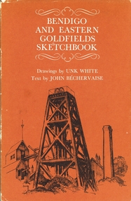
Book - BENDIGO AND EASTERN GOLDFIELDS SKETCHBOOK, 1970
... Bendigo Historical Society Inc. History House 11 Mackenzie Street Bendigo goldfields HISTORY bendigo and other areas of vic. John Bechervaise Bendigo and Eastern Goldfields Sketchbook. Signature in front of book, however, does not look like the author's, dated 1973. Drawings by Unk White. Artwork and comments re buildings, mines, goals, and others of importance and contributed to by the location ...Bendigo and Eastern Goldfields Sketchbook. Signature in front of book, however, does not look like the author's, dated 1973. Drawings by Unk White. Artwork and comments re buildings, mines, goals, and others of importance and contributed to by the location of gold in those areas. With Index. 64 pages Brown dust jacket over hard cover.John Bechervaisehistory, bendigo and other areas of vic. -
 Bendigo Historical Society Inc.
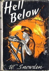
Book - HELL BELOW - LEADER, 1959
... Bendigo Historical Society Inc. History House 11 Mackenzie Street Bendigo goldfields BENDIGO Mining conditions at the time. W Snowden 'Hell Below'. The romance of gold - fictional story of mining at Bendigo, told from the viewpoint of a man who worked below. Reference to known mines and locations ...'Hell Below'. The romance of gold - fictional story of mining at Bendigo, told from the viewpoint of a man who worked below. Reference to known mines and locations in Bendigo.W Snowdenbendigo, mining, conditions at the time. -
 Bendigo Historical Society Inc.
Document - LONG GULLY HISTORY GROUP COLLECTION: THE BENDIGO GOLDFIELD … INTRODUCTION TO FIELD
... Mines mentioned are: The Deborah, The North Deborah, Central Deborah, The New Red White and Blue Consolidated (Big Blue), North Red White and Blue, Central Red white and Blue, Little 180, South Ironbark, Ironbark, Hercules, Central Nell Gwynne and The New Chum Syncline. Lansell's Bendigo Battery is also mentioned. There is a short description of each mine, depth. location, machinery, Gold yield, Dividends and Calls. Closing date of some (some closed as a result of fire). Also mentioned is the postal service and the establishment of cemeteries at Bendigo, White Hills, Eaglehawk and Kangaroo Flat. Document LONG GULLY HISTORY ...The Bendigo Goldfield ...Introduction to Field. Compiled by A. Richardson. Mentioned are the Deborah Line of Reef, The Sheepshead Line, The Nell Gwynne Line and The Carshalton Line of Reef. Mines mentioned are: The Deborah, The North Deborah, Central Deborah, The New Red White and Blue Consolidated (Big Blue), North Red White and Blue, Central Red white and Blue, Little 180, South Ironbark, Ironbark, Hercules, Central Nell Gwynne and The New Chum Syncline. Lansell's Bendigo Battery is also mentioned. There is a short description of each mine, depth. location, machinery, Gold yield, Dividends and Calls. Closing date of some (some closed as a result of fire). Also mentioned is the postal service and the establishment of cemeteries at Bendigo, White Hills, Eaglehawk and Kangaroo Flat.Albert Richardsonbendigo, history, long gully history group, the long gully history group - the bendigo goldfield...introduction to field, a richardson, new chum railway mine, the dascombe nugget, the victoria nugget, r r haverfield, ballerstadt, rae, wittscheibe, lazarus, cave and amos, geo lansell, the old chum, victoria, specimen, hustlers, bendigo amalgamated goldfields, bendigo mines limited, nell gwynne, napoleon, carshalton, the deborah, roberts & sons, the north deborah, williams' united, central deborah, lansell's south red white & blue, the new red white and blue consolidated (big blue), union, h harkness & co, thompson & co, lansell's bendigo battery, showgrounds industrial hall, north red white and blue, central red white and blue, little 180, john brown knitwear factory, south ironbark, victoria consols east shaft, ironbark, manchester arms hotel, unity mine, wattle gully mine chewton, hercules, hercules and energetic, bendigo amalgamated goldfields coy, long gully post office, the old wheal owl, central nell gwynne, gold mines hotel, bendigo city council, mr jack barker, bendigo and district tourist association, the new chum syncline, courier of the mines newspaper, camp hill school, sandhurst east post office, bendigo cemetery, white hills cemetery, eaglehawk cemetery, kangaroo flat cemetery -
 Bendigo Historical Society Inc.
Container - CLAY CRUCIBLE
... Bendigo Historical Society Inc. History House 11 Mackenzie Street Bendigo goldfields GOLD MINES Mining equipment Gold Crucible Juleff Clay gold crucible used for smelting, assaying and refining gold. Inside of crucible discoloured with brown and pale green mark. Maker's name on side: 'Juleff, number 78, (location ...Clay gold crucible used for smelting, assaying and refining gold. Inside of crucible discoloured with brown and pale green mark. Maker's name on side: 'Juleff, number 78, (location indecipherable) England.Juleffgold mines, mining equipment, gold crucible -
 Bendigo Historical Society Inc.
Document - FOSTERVILLE GOLD MINE COLLECTION: OPEN DAY 2018
... Bendigo Historical Society Inc. History House 11 Mackenzie Street Bendigo goldfields BENDIGO Mining Fosterville Gold Mine 2 page document, coloured, titled 'Kirkland Lake Gold' and 'Welcome to the Fosterville Gold Mine Open Day 2018'. Document describes activities available to visitors on the 2018 Open Day, and a map of the mine site showing location ...2 page document, coloured, titled 'Kirkland Lake Gold' and 'Welcome to the Fosterville Gold Mine Open Day 2018'. Document describes activities available to visitors on the 2018 Open Day, and a map of the mine site showing location of various displays.bendigo, mining, fosterville gold mine -
 Bendigo Historical Society Inc.
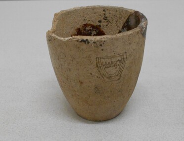
Document - MCCOLL, RANKIN AND STANISTREET COLLECTION: NAPOLEON REEF GOLD MINING CO. N.L, 1940
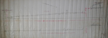
... Bendigo Historical Society Inc. History House 11 Mackenzie Street Bendigo goldfields ORGANIZATION Business industrial - mining McColl Rankin & Stanistreet mining gold mining Napoleon Reef Document: 4 copies of plan of Transverse Section of Napoleon Anticline Lease no 10970, plan shows proposed shaft location and depth (1000 ft), for Napoleon Reef Gold Mining Co, also location and depth of adjacent Central Nell Gwynne Shaft scale 100ft = 1 inch, Prepared by J.J. Caldwell Mines ...Document: 4 copies of plan of Transverse Section of Napoleon Anticline Lease no 10970, plan shows proposed shaft location and depth (1000 ft), for Napoleon Reef Gold Mining Co, also location and depth of adjacent Central Nell Gwynne Shaft scale 100ft = 1 inch, Prepared by J.J. Caldwell Mines Dept Bendigo.organization, business, industrial - mining, mccoll rankin & stanistreet, mining, gold mining, napoleon reef -
 Bendigo Historical Society Inc.
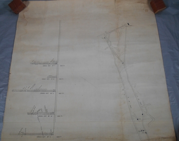
Document - MCCOLL, RANKIN AND STANISTREET COLLECTION: DEBORAH EXTENDED GOLD MINING CO. NL, 1940
... Bendigo Historical Society Inc. History House 11 Mackenzie Street Bendigo goldfields ORGANIZATION Mining deborah extended gold mining co nl McColl Rankin & Stanistreet Deborah Extended Gold Mining Co NL lease McColl Rankin & Stanistreet, Deborah Extended Gold Mining Co. No Liability, Lease. Inscription: Mortgagee under Mortgage N'bd... has consented to this Lease, See consent endorsed heron (signed) F O Hewison Assistant Registrar, Registrar of Titles 14 May 1941. Leases Copy. Other signatures: Donald McKinnon, Jean Woods, Jamie Jepson, Angus Mackay, J Stanistreet, A Gilcrist, ? Healy. Common Seal for: The Bank of Australasia and Deborah Ext Gold Mining Co NL. 2 maps of mine location ...McColl Rankin & Stanistreet, Deborah Extended Gold Mining Co. No Liability, Lease. Inscription: Mortgagee under Mortgage N'bd... has consented to this Lease, See consent endorsed heron (signed) F O Hewison Assistant Registrar, Registrar of Titles 14 May 1941. Leases Copy. Other signatures: Donald McKinnon, Jean Woods, Jamie Jepson, Angus Mackay, J Stanistreet, A Gilcrist, ? Healy. Common Seal for: The Bank of Australasia and Deborah Ext Gold Mining Co NL. 2 maps of mine location.organization, mining, deborah extended gold mining co nl, mccoll rankin & stanistreet, deborah extended gold mining co nl lease -
 Bendigo Historical Society Inc.
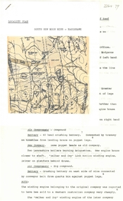
Map - BIG 180 SHAFT POSITION, No date visible
... Bendigo Historical Society Inc. History House 11 Mackenzie Street Bendigo goldfields MAP Bendigo mining plan Mining Gold Mines. Victoria Hill Big 180 Map: Plan showing the location of various shafts in the Victoria Hill area, hand draughted in pencil. ...Map: Plan showing the location of various shafts in the Victoria Hill area, hand draughted in pencil. Scale 2 Chains to 1 inchmap, bendigo, mining plan, mining , gold mines. victoria hill, big 180 -
 Bendigo Historical Society Inc.
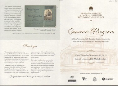
Document - ANZAC COLLECTION: SOUVENIR PROGRAM OFFICIAL OPENING OF THE BENDIGO SOLDIERS' MEMORIAL MILITARY MUSEUM, Thursday 15th November, 2
... Bendigo. Program outlines the sequence of activities relating to the opening and provides an overview of the history of the Soldiers' Memorial. The site was formerly the location of the Hustlers Royal Reserve No. 2 Mine, Pall Mall, from 1871 - 1912....Bendigo Historical Society Inc. History House 11 Mackenzie Street Bendigo goldfields BENDIGO Buildings Bendigo Soldiers' Memorial Bendigo Soldiers Memorial Institute Program, lemon coloured document, gold and black print. On front " Bendigo Soldiers' Memorial Institute Revitalisation project. Souvenir Program. Official opening of the Bendigo soldiers' Memorial Institute Revitalisation and Military Museum. 10 a.m. Thursday November 15, 2018. Lansell Gardens, pall Mall, Bendigo. Program outlines the sequence of activities relating to the opening and provides an overview of the history of the Soldiers' Memorial. The site was formerly the location of the Hustlers Royal Reserve No. 2 Mine ...Program, lemon coloured document, gold and black print. On front " Bendigo Soldiers' Memorial Institute Revitalisation project. Souvenir Program. Official opening of the Bendigo soldiers' Memorial Institute Revitalisation and Military Museum. 10 a.m. Thursday November 15, 2018. Lansell Gardens, pall Mall, Bendigo. Program outlines the sequence of activities relating to the opening and provides an overview of the history of the Soldiers' Memorial. The site was formerly the location of the Hustlers Royal Reserve No. 2 Mine, Pall Mall, from 1871 - 1912.Bendigo Soldiers Memorial Institutebendigo, buildings, bendigo soldiers' memorial -
 The Beechworth Burke Museum
Postcard, George Symons, c.1990
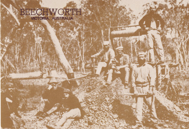
... mine shaft in the Beechworth region. The photograph has been dated to approximately 1872. This period in history post-dates the Victorian gold rushes which occurred 1852-1853 in Ballarat, Bendigo and Beechworth. During this period, in the 1870s, the surface alluvial gold had been discovered and removed from location...mine shaft in the Beechworth region. The photograph has been dated to approximately 1872. This period in history post-dates the Victorian gold rushes which occurred 1852-1853 in Ballarat, Bendigo and Beechworth. During this period, in the 1870s, the surface alluvial gold had been discovered and removed from location ...The photograph printed on this postcard comes from the collection of the Mitchell Library in Sydney. It is sepia in tone and depicts seven men standing and sitting around a mine shaft in the Beechworth region. The photograph has been dated to approximately 1872. This period in history post-dates the Victorian gold rushes which occurred 1852-1853 in Ballarat, Bendigo and Beechworth. During this period, in the 1870s, the surface alluvial gold had been discovered and removed from location. Therefore, in order to reach the deeper and less accessible alluvial gold, diggers began to dig shafts into the earth. These shafts sunk below the ground level by 20 to 30 feet and required timber structures around the entrance and winches to bring the paydirt to the top. The top of this wooden structure is visible behind the man standing in the upper right of the image. This type of mining was highly dangerous as mines often caved in which injured the minors and often resulted in death. Thus, following this period, in the early 1900s, miners opted instead for hydrolic slucing which cut away the earth without the devastating consequences of a mine cave in. This particular group of miners appear to have been unable to afford a horse (then worth around 50 pounds) which were generally used at mines like this to help pull buckets attached to ropes up and down the mine. Instead, this group brought the buckets up and down by windlass. The windlass was a wooden structure mounted over the mining shaft and fitted with a hand-cranked winch which enabled the bucket attached to the rope to be brought up and down.Gold was first discovered in Beechworth in Spring and Reid's Creek in the summer of 1852-1853. At its popularity, this region had approximately 8000 people on the gold fields searching for gold on the banks of these creeks. These periods did not require the use of heavy machinery or the digging of deep mining shafts like the one depicted in this image. Therefore, this image has important connotations for the technologies associated with mining during the approximated 1870s when gold was harder to access. This is a later period in gold history which does not fit into the "gold rush" period. Instead, it occurred after the surface gold had disappeared and therefore, is essential for researchers who are investigating the mining techniques and structures used to reach the alluvial gold which was located deeper under ground in the 1870s. This period predates the use of big heavy machinery used to mine in the 1900s which include dredges. Images such as this one can also impart essential information as to the wardrobe and fashion of men during this period. It also imparts knowledge about the landscape of Beechworth which is useful for people researching the environment and impact of gold mining in the north-east region of Victoria. In addition, since this image is a postcard reproduction of an early Australian image which may date to approximately 1990 it can impart knowledge as to the interests of people during this time period when there may have been an increase into Australian history.A sepia tone facsimile of an early Australian photograph (circa 1872) printed as a postcard.Obverse: BEECHWORTH / Victoria, Australia / Reverse: GM 2 3275 / CORRESPONDENCE / AUSTRALIAN / YESTERYEAR / CARDS / ADDRESS / Published by George Symons (057) 65 3240 / THE MINEHEAD C. 1872 / The easily gleaned gold of the early fields did / not last very long. In order to reach less / accessible alluvial gold diggers began sinking shafts as much as twenty to thirty feet down / and the mines required timbering and winches / to bring the paydirt to the top. / This syndicate has been unable to afford the / luxury of a horse (about 50 pounds) and so everything / must go up and down by windlass and rawhide / bucket. / Photo: Mitchell Library, Sydney / A sepia tone facsimile of / an early Australian photographmining album, gold mine, beechworth, burke museum, mine shaft, postcard, australian yesteryear cards, george symons, the minehead, gold fields, alluvial gold, early australia, c.1872, 1872, gold diggers, north east victoria -
Bendigo Historical Society Inc.
Plan - Russell's Reef, Lauriston
... Bendigo Historical Society Inc. History House 11 Mackenzie Street Bendigo goldfields A quartz mine that dates from the early years of the 20th-century. The remains are located on a Water Reserve managed by Coliban Water. Location ...A quartz mine that dates from the early years of the 20th-century. The remains are located on a Water Reserve managed by Coliban Water. Location: Reservoir Road, Lauriston, Macedon Ranges Shire. The Russell’s Reef Amalgamated Company spent the early part of 1907 in developing the saddle reef. Defects found to exist in the winding gear, consequently the directors decided to obtain a new gear of the first-class type. This has been obtained and placed in position. Advantage was taken by the management of the suspension of underground operations to give the whole of the machinery and boilers at the No 1 shaft a thorough overhaul. It was found that the two boilers that had been in use required some slight repairs. This resulted in a new high pressure boiler which had been purchased some time previously has been built in and put into commission. In 1907 the shaft was 1,260 feet deep, and an average of 30 men were employed. Russell’s Reef Amalgamated , No 2 shaft ( Company was formed c.1891 and appears to have mined more-or-less continuously until 1911) Source: chrome-extension://efaidnbmnnnibpcajpcglclefindmkaj/https://vhd.heritagecouncil.vic.gov.au/places/8099/download-reportRussell's Reef Amalgamated Co.Lauriston Plan forms part of the Margaret Roberts Collection.gold mining, gold, transverse section, lauriston, russell's reef, kyneton -
 Bendigo Historical Society Inc.
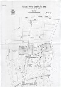
Plan - Hustler's Royal Reserve No. 2 Mine, April, 2014
... Bendigo Historical Society Inc. History House 11 Mackenzie Street Bendigo goldfields goldmining accident quartz mining Hustler's Royal Reserve No. 2 Mine Park Shaft Hustler's line of reef Gaol One page plan (photocopy) of Hustler's Royal Reserve No. 2 Mine (Park Shaft) showing mine location, dams, tennis courts, bowling green, Jail (sic) Barnard Street, View Street and Park Road. ...One page plan (photocopy) of Hustler's Royal Reserve No. 2 Mine (Park Shaft) showing mine location, dams, tennis courts, bowling green, Jail (sic) Barnard Street, View Street and Park Road. Whitelaw plan, 1913.goldmining, accident, quartz, mining, hustler's royal reserve no. 2 mine, park shaft, hustler's line of reef, gaol, -
 Bendigo Historical Society Inc.
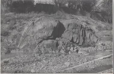
Photograph - Napoleon Anticline, 1935
... Bendigo Historical Society Inc. History House 11 Mackenzie Street Bendigo goldfields In structural geology, an anticline is a type of fold that is an arch-like shape and has its oldest beds at its core, whereas a syncline is the inverse of an anticline. A typical anticline is convex up in which the hinge or crest is the location where the curvature is greatest, and the limbs are the sides of the fold that dip away from the hinge. Significant to mining history of Bendigo. Napoleon Gold Mine ...In structural geology, an anticline is a type of fold that is an arch-like shape and has its oldest beds at its core, whereas a syncline is the inverse of an anticline. A typical anticline is convex up in which the hinge or crest is the location where the curvature is greatest, and the limbs are the sides of the fold that dip away from the hinge.Significant to mining history of Bendigo.Black and white photograph: rock formation, anticline with an archlike shape in centre of image. Written in pencil on back of photograph : 'Napoleon anticline Golden Square'.napoleon gold mine, anticline -
 Bendigo Historical Society Inc.
Plan - South Frederick The Great Mine, Sebastian
... Bendigo Historical Society Inc. History House 11 Mackenzie Street Bendigo goldfields SOUTH FREDERICK THE GREAT MINE Location Unreserved Crown Land along the southern boundary of Sebastian School, east of Three Chain Road, Frederick the Great/Carshalton Reef, Sebastian Map Reference Raywood 1:25000 - BV488.447 Mine site: Capped shaft still surrounded by its mullock paddock. ...SOUTH FREDERICK THE GREAT MINE Location Unreserved Crown Land along the southern boundary of Sebastian School, east of Three Chain Road, Frederick the Great/Carshalton Reef, Sebastian Map Reference Raywood 1:25000 - BV488.447 Mine site: Capped shaft still surrounded by its mullock paddock. At the base of the paddock on the northern side is a concrete winding engine foundation measuring 8 by 4 feet, and standing 2 feet high. The foundation has ¾-inch mounting bolts. Battery site 70 metres to the west of the mine site are the concrete foundations of a 10head battery. The foundations measure 16 by 11 feet, and stand 4 feet high. Part of the battery's loading ramp still survives, and on the eastern side of the battery foundations is a large concrete engine foundation. Near this engine foundation is a 3 foot square concrete pad, which still retains a circular impression. Presumably this was a stand for a gas producer cylinder. Located between the battery and the mine site is a rubbish dump which contains sections of an iron stack, and perhaps the remains of the gas producer cylinder. History Period of activity: 1871 (South Frederick the Great); 1881-1889 (Amalgamated South Frederick the Great); 1897-1906 (South Frederick the Great); 1933-1937 (South Frederick the Great) Line of reef: Sebastian/Carshalton Maximum recorded annual production: unknown Total production: 511ozs obtained from 1773 tons between 1934 and 1937 Deepest working level: 300 feet (Amalgamated South Frederick the Great) Deepest shaft: 307 feet (Amalgamated South Frederick the Great)(below water level) Source: City of Greater Bendigo: Marong Heritage Study chrome-extension://efaidnbmnnnibpcajpcglclefindmkaj/http://images.heritage.vic.gov.au/attachment/70493Mining SitesTransverse and longitudinal plans on one sheet, of South Frederick The Great Mine, Sebastian. Forms part of the Margaret Roberts Collection of mining records.bendigo, margaret roberts, gold, south frederick the great mine, margaret roberts collection, sebastian -
 Bendigo Historical Society Inc.
Plan - New Chum Goldfields Co. N.L, 20.7.1912
... Bendigo Historical Society Inc. History House 11 Mackenzie Street Bendigo goldfields New Chum Goldfield Co. was located at the Diamond Hill Road end of Spring Gully Reservoir. Latitude: -36.8114952741, Longitude: 144.2747542333 The location is now within the fenced area of the Spring Gully Reservoir, and not accessible. gold mining gold Bendigo New Chum Goldfields Co. N.L. Spring Gully Reservoir New Chum Goldfields Mine ...New Chum Goldfield Co. was located at the Diamond Hill Road end of Spring Gully Reservoir. Latitude: -36.8114952741, Longitude: 144.2747542333 The location is now within the fenced area of the Spring Gully Reservoir, and not accessible. New Chum Goldfields Mine longitudinal plan. Written on plan 'W.H. Cundy, 20.7.12' Plan forms part of the Margaret Roberts Collection.gold mining, gold, bendigo, new chum goldfields co. n.l., spring gully reservoir -
 Bendigo Historical Society Inc.
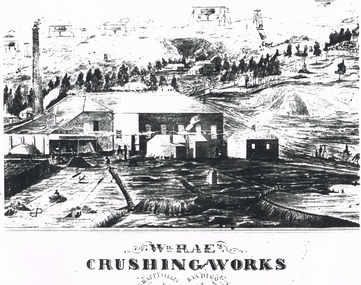
Document - LONG GULLY HISTORY GROUP COLLECTION: WM RAE CRUSHING WORKS
... location in Happy Valley, where he set up a crushing battery with 35 heads. BENDIGO History long gully history group The Long Gully History Group - Wm Rae Crushing Works George Ellis Sketch of a crushing works. Printed underneath is: Wm. Rae's Crushing Works, Happy Valley, Bendigo. Written on the back is: Happy Valley Rd. South side below Wells St. Picture shows a crushing works building with a tall chimney and some smaller outbuildings. On the hill in the background are poppet legs, other mine ...William Rae (1823-1887) was born into a farming family in Scotland and came to Australia in i852. After coming to the Bendigo area, he established a puddling machine in American Gully. He then bought a claim on the Victoria reef and was quite successful. Subsequently he bought a steam engine and three batteries to begin crushing quartz. This was such a boon that he moved to a more convenient location in Happy Valley, where he set up a crushing battery with 35 heads.Sketch of a crushing works. Printed underneath is: Wm. Rae's Crushing Works, Happy Valley, Bendigo. Written on the back is: Happy Valley Rd. South side below Wells St. Picture shows a crushing works building with a tall chimney and some smaller outbuildings. On the hill in the background are poppet legs, other mine structures and some trees. There are heaps of mullock and in the foreground are a number of people.bendigo, history, long gully history group, the long gully history group - wm rae crushing works, george ellis -
 Bendigo Historical Society Inc.
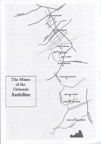
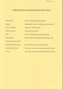
Document - CENTRAL DEBORAH GOLD MINE: MINES ALONG THE DEBORAH ANTICLINE
... Bendigo Historical Society Inc. History House 11 Mackenzie Street Bendigo goldfields BHS Collection BENDIGO Mining deborah gold mines Deborah Gold mines Plan of reef line showing the location of the Deborah Gold Mines. ...BHS CollectionPlan of reef line showing the location of the Deborah Gold Mines. Drawn by Philip Wilkin for the 60th anniversary of the closing of the Central Deborah Gold Mine.bendigo, mining, deborah gold mines, deborah gold mines -
 Bendigo Historical Society Inc.
Document - CENTRAL DEBORAH GOLD MINE: ADDITIONAL MINES ALONG THE DEBORAH LINE OF REEF
... Bendigo Historical Society Inc. History House 11 Mackenzie Street Bendigo goldfields BHS Collection BENDIGO Mining central deborah gold mine Central Deborah Gold Mine A4 yellow paper. List of additional mines along the Deborah reef. Walter Scott, Tadmor, Rose of England, Herschel and Tait, Vital, Metropolitan, Metropolitan South shaft, Monument Hill Central, Monument Hill old, Violet. Locations ...BHS CollectionA4 yellow paper. List of additional mines along the Deborah reef. Walter Scott, Tadmor, Rose of England, Herschel and Tait, Vital, Metropolitan, Metropolitan South shaft, Monument Hill Central, Monument Hill old, Violet. Locations of each mine listed with name.bendigo, mining, central deborah gold mine, central deborah gold mine -
 Bendigo Historical Society Inc.
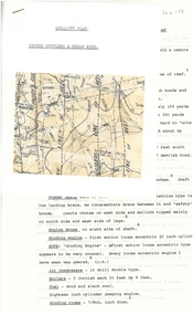
Document - ALBERT RICHARDSON COLLECTION: THE PEARL MINE
... Typed, 2 page document, detailing the location and history of the operation of the Pearl Mine. The mine was located approximately 2 miles north west from the Bendigo Post Office. ...Bendigo Historical Society Inc. History House 11 Mackenzie Street Bendigo goldfields BENDIGO Mining pearl company mine Typed, 2 page document, detailing the location and history of the operation of the Pearl Mine. ...Typed, 2 page document, detailing the location and history of the operation of the Pearl Mine. The mine was located approximately 2 miles north west from the Bendigo Post Office. The main shaft was put down to 1613 feet and 3 subsidiary shafts were sunk, Information is given about the south shaft, originally the main shaft of the Great Extended Hercules and the east shaft, which was situated on the Sheepshead line.bendigo, mining, pearl company mine -
 Bendigo Historical Society Inc.
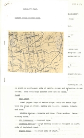
Document - ALBERT RICHARDSON COLLECTION: SOUTH NEW MOON MINE EAGLEHAWK
... Bendigo Historical Society Inc. History House 11 Mackenzie Street Bendigo goldfields BENDIGO Mining south new moon gold mine Two-page typed document with map, detailing information on the South New Moon Gold Mine on the Garden Gully line of reef. Information includes the location ...Two-page typed document with map, detailing information on the South New Moon Gold Mine on the Garden Gully line of reef. Information includes the location, depth of shaft, steel poppet legs, engine house, air compressor, battery, company ownership, battery. The shaft The 'Walker and Coy' winding engine of the later company together with poppet heads was removed later to the South Virginia company between Napier and Market Street, Eaglehawk. Gold production from both companies who owned the mine was 257,498 oz.'.bendigo, mining, south new moon gold mine -
 Bendigo Historical Society Inc.
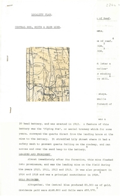
Document - ALBERT RICHARDSON COLLECTION: UNITED HUSTLERS AND REDAN MINE
... Bendigo Historical Society Inc. History House 11 Mackenzie Street Bendigo goldfields BENDIGO Mining united hustlers and redan mine Four-page typed document plus location map. ...Four-page typed document plus location map. The United Hustlers and Redan mine was located in the North Bendigo, Long Gully area on the Hustlers line of reef. The lease was 153 acres and included Holdsworth, Holmes, Havilah Roads and Wood Street. The Redan shaft was 1,830ft and the South or K.K. Shaft was 1,960 ft. Poppet legs steel 71 ft high. Features of the plant are described including the engine house, winding engine, air compressor, boilers, fuel, winding ropes.bendigo, mining, united hustlers and redan mine -
 Bendigo Historical Society Inc.
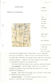
Document - ALBERT RICHARDSON COLLECTION: CENTRAL NELL GWYNNE MINE
... Bendigo Historical Society Inc. History House 11 Mackenzie Street Bendigo goldfields BENDIGO Mining central nell gwynne Two-page typed document plus location map. The Central Nell Gwynne gold mine ...Two-page typed document plus location map. The Central Nell Gwynne gold mine was located off Happy Valley Road, first turn to the left from Marong Road, and up on the hill. The shaft depth was 1,912 ft. The original plant had small wooden poppet legs and a steam winch which were replaced, in 1935/36 by steel poppet legs obtained from the Virginia mine at Eaglehawk. Features and history of the plant are described including the winding engine, air compressor, boilers, and crushing battery. The dividends and gold production figures are given. The total yield of gold was 61,884 oz.bendigo, mining, central nell gwynne -
 Bendigo Historical Society Inc.
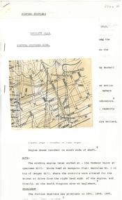
Document - ALBERT RICHARDSON COLLECTION: FORTUNA HUSTLERS MINE
... Bendigo Historical Society Inc. History House 11 Mackenzie Street Bendigo goldfields BENDIGO Mining fortuna hustlers mine Two-page document with location map. ...Two-page document with location map. The Fortuna Hustlers Gold mine was located close to the railway goods shed (Discovery Centre location) in an area occupied by Buckell and Jeffrey's office and yards. (now carpark of Marketplace shopping centre). It commenced operation in August 1888 and closed in December 1913.The depth of the shaft was 2,240ft. Features of the plant described are: the winding engine, the air compressor, boilers, baling tanks, poppet legs, engine house. The winding engine later worked at the Tambour Major at Specimen Hill; Birds Reef at Kangaroo Flat, Hercules No. 1 on top of Danger Hill and the North Virginia mine at Eaglehawk.bendigo, mining, fortuna hustlers mine -
 Bendigo Historical Society Inc.
Document - ALBERT RICHARDSON COLLECTION: CENTRAL RED, WHITE AND BLUE MINE
... Bendigo Historical Society Inc. History House 11 Mackenzie Street Bendigo goldfields Bendigo Mining Central Red White & blue mine Two-page typed document plus location map. ...Two-page typed document plus location map. The location of the Central Red, White and Blue mine was on the north-west corner of Barnard and Honeysuckle Streets, Golden Square. The mine was formed in 1910 and ceased operations in 1936. Features of the mine are described: the winding engine, boilers, air compressor, poppet legs, engine house, crushing battery, gold produced and where obtained from. 'The rich gold yields which made this mine so prominent in its early years, was obtained from a large reef at the 318 feet level, some yields reached as high as 15 oz to the ton'.bendigo, mining, central red, white & blue mine -
 Bendigo Historical Society Inc.
Document - ALBERT RICHARDSON COLLECTION: GARDEN GULLY UNITED MINE
... location of the Garden Gully United Mine. The history and features of the mine operation are described and include: the locality of the shafts, winding engine, air compressor, crushing battery, engine house, gold obtained and dividends and gold production. The lookout tower in Rosalind Park was formerly the poppet legs of the Garden Gully United Gold Mining Company. Albert Richardson writes: ' a fitting tribute to Bendigo's...Bendigo Historical Society Inc. History House 11 Mackenzie Street Bendigo goldfields BENDIGO Mining Garden Gully United Mine gold mining poppet legs Rosalind Park Three-page typed document plus map showing location of the Garden Gully United Mine. ...Three-page typed document plus map showing location of the Garden Gully United Mine. The history and features of the mine operation are described and include: the locality of the shafts, winding engine, air compressor, crushing battery, engine house, gold obtained and dividends and gold production. The lookout tower in Rosalind Park was formerly the poppet legs of the Garden Gully United Gold Mining Company. Albert Richardson writes: ' a fitting tribute to Bendigo's most famous goldmine. The four-legged lookout tower was originally the six-legged poppet legs of the Garden Gully United.bendigo, mining, garden gully united mine, gold mining, poppet legs, rosalind park -
 Bendigo Historical Society Inc.
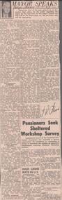
Newspaper - ALBERT RICHARDSON COLLECTION: THE MAYOR SPEAKS: MINE SITES
... Bendigo Historical Society Inc. History House 11 Mackenzie Street Bendigo goldfields BENDIGO Mining reef lines and mines Newspaper article 'The Mayor Speaks' dated 12th August 1967, Bendigo Advertiser. Article by J.R. Flood. Mayor of Bendigo, detailing the location ...Newspaper article 'The Mayor Speaks' dated 12th August 1967, Bendigo Advertiser. Article by J.R. Flood. Mayor of Bendigo, detailing the location of mines including the Duchess of Edinburgh on the New Chum line, the mines on the Christmas line of reef, the Deborah reef mines, and the Sheepshead reef. Mine reclamation schemes are also addressed in the articlebendigo, mining, reef lines and mines -
 Bendigo Historical Society Inc.
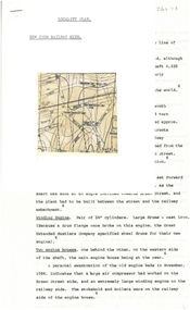
Document - ALBERT RICHARDSON COLLECTION: NEW CHUM RAILWAY MINE, GOLDEN SQUARE
... Bendigo Historical Society Inc. History House 11 Mackenzie Street Bendigo goldfields BENDIGO Mining new chum railway gold mine Three-page typed document plus map. Document details location ...Three-page typed document plus map. Document details location and history of the New Chum Railway Mine, Golden Square and includes: depth of shaft, size of lease, locality, poppet legs, winding engine, engine houses, crushing battery, best gold obtained, prominence, and total gold production and dividends. References provided. Document forms part of research referred to in Albert Richardson's paper 2264.70.bendigo, mining, new chum railway gold mine -
 Bendigo Historical Society Inc.
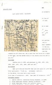
Document - ALBERT RICHARDSON COLLECTION: LADY BARKLY MINE, EAGLEHAWK
... Bendigo Historical Society Inc. History House 11 Mackenzie Street Bendigo goldfields BENDIGO Mining lady barkly mine eaglehawk One page document, plus map, with information on the Lady Barkly Mine, New Chum line of reef, Eaglehawk. The location ...One page document, plus map, with information on the Lady Barkly Mine, New Chum line of reef, Eaglehawk. The location, early history, prominence, and gold production are described. References given on bottom of document. Document forms part of research referred to in Albert Richardson's paper 2264.70.bendigo, mining, lady barkly mine eaglehawk