Showing 17 items matching "history maps points of interest"
-
 Clunes Museum
Document
... ...HISTORY MAPS POINTS OF INTEREST....1 DAYLESFORD AND HEPBURN SPRINGS 14 PAGES, ACCOMMODATION, SITES, CHURCHES, MAPS .2 TALBOT TOWNSHIP, SHORT HISTORY AND POINTS OF INTEREST...Clunes Museum 36 Fraser Street enter building through Collins Place Clunes goldfields TALBOT DAYLESFORD HEPBURN SPRINGS HISTORY MAPS POINTS OF INTEREST .1 DAYLESFORD AND HEPBURN SPRINGS 14 PAGES, ACCOMMODATION, SITES, CHURCHES, MAPS .2 TALBOT TOWNSHIP, SHORT HISTORY AND POINTS OF INTEREST Document DOCUMENT ....1 DAYLESFORD AND HEPBURN SPRINGS 14 PAGES, ACCOMMODATION, SITES, CHURCHES, MAPS .2 TALBOT TOWNSHIP, SHORT HISTORY AND POINTS OF INTERESTtalbot, daylesford hepburn springs, history maps points of interest -
 Warrnambool and District Historical Society Inc.
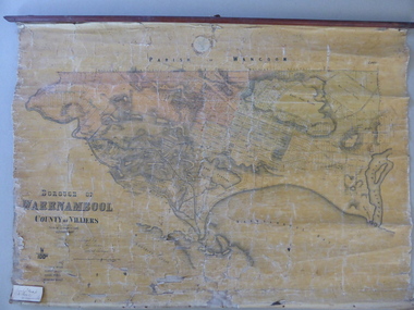
Mao, Borough of Warrnambool, County of Villiers, 1873
... interest. History of Warrnambool Charles Hider Henry Marfell ‘Early Map of W’bool, H.G. Marfell’ This is a wax paper map mounted on cloth. At the top it is attached by nails to a piece of wood and at the top it has a cloth ring for hanging the map. The map is in black shadings on a yellow background. The map is badly creased and coming away from the cloth at the edges and at other various points ...This is an early map of the Borough of Warrnambool (1872/3) showing the central town area of Warrnambool and the surrounding district. Reserves, public buildings and some businesses are marked. The map was photolithographed by John Noone, a Melbourne artist and photographer who claimed in 1858 to have the oldest-existing photographic studio in Melbourne. Photolithography was a process first developed in Melbourne. For several years Noone was the official photographer for the Victorian Crown Lands Office and for the Victorian Public Library and Museum. The map has the stamp of the seller of the map – Charles Hider, the well-known stationer and bookseller in Timor Street, Warrnambool. The owner of the map, Henry George Marfell, (1883-1962) was the son of John and Mary Ann Marfell. The Marfells were well-known in Warrnambool as grain merchants and managers of the Warrnambool Co-Operative Milling Company. It is surmised from the writing on the Marfell label that this map was at some stage given by Henry Marfell to the old Warrnambool MuseumThis map of early Warrnambool is of considerable significance, firstly because its original state and early date (1873) make it of antiquarian and historical interest. Also the connection with the names, Charles Hider and Henry Marfell and the old Museum gives it added provenance and interest.This is a wax paper map mounted on cloth. At the top it is attached by nails to a piece of wood and at the top it has a cloth ring for hanging the map. The map is in black shadings on a yellow background. The map is badly creased and coming away from the cloth at the edges and at other various points. There is some red or pink marking or staining on the township area of the map (originally the sold lands on this map were coloured in brown and the reserves, buildings, etc in pink). On the left hand corner there is a piece of paper glued on with some handwriting in ink (Marfell). There is also the stamp of the seller of the map – Charles Hider, stationer and bookseller, of Timor Street Warrnambool‘Early Map of W’bool, H.G. Marfell’ history of warrnambool, charles hider, henry marfell -
 Bendigo Historical Society Inc.
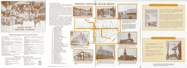
Document - BASIL MILLER COLLECTION: BENDIGO HISTORIC WALK/DRIVE
... History House 11 Mackenzie Street Bendigo goldfields PERSON Individual basil miller One fold out sheet with a map and descriptions of points of interest at each nominated site. ...One fold out sheet with a map and descriptions of points of interest at each nominated site.person, individual, basil miller -
 Bendigo Historical Society Inc.
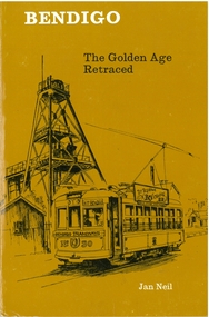
Book - BENDIGO THE GOLDEN AGE RETRACED, 1973
... History House 11 Mackenzie Street Bendigo goldfields BENDIGO Buildings effects of gold in bendigo. . Jan Neil Bendigo the golden age retraced Front cover is a map of the area using white lines to point out points of interest in Bendigo. ...Bendigo the golden age retraced Front cover is a map of the area using white lines to point out points of interest in Bendigo. These places are then described in brief detail through the book. There are also illustrations of each place of interest. Part A has a signature inside the front cover dated 1973. b, has a photo of 'Sun Loong' in front of the Shamrock Hotel, at easter time. This is in a plastic folder which is then inside a folded card, with a drawing of the old Town Hall on the front. C, has a library sticker on the lower spine, numbered 0035 nei. With Index. 64 pages.Jan Neilbendigo, buildings, effects of gold in bendigo., . -
 Greensborough Historical Society
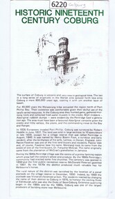
Leaflet, Coburg Historical Society, Historic nineteenth century Coburg, 1980s
... A short history of 19th century Coburg, Victoria covering points of interest. Includes a map of the landmarks covered in the text. ...Greensborough Historical Society 34A Glenauburn Road Lower Plenty Lower Plenty melbourne A short history of 19th century Coburg, Victoria covering points of interest. Includes a map of the landmarks covered in the text. coburg (victoria) pentridge One page, printed on both sides in black and white text, drawings and photographs. ...A short history of 19th century Coburg, Victoria covering points of interest. Includes a map of the landmarks covered in the text. One page, printed on both sides in black and white text, drawings and photographs. Folded into 5. coburg (victoria), pentridge -
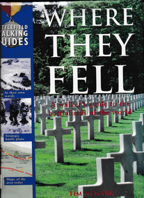 Monbulk RSL Sub Branch
Book, Five mile press, Where they fell : a walker's guide to the battlefields of the world, 2000
... Monbulk RSL Sub Branch 48 Main Road Monbulk yarra-valley-and-the-dandenong-ranges Battlefields - Guidebooks Battles - History Combining vivid illustrations, dramatic photos in color and black-and-white, battle maps, landscape diagrams, and fascinating features, this volume recounts 17 military campaigns that changed the course of history. It also serves as a superb travel guide ..., suggesting points of interest ...Combining vivid illustrations, dramatic photos in color and black-and-white, battle maps, landscape diagrams, and fascinating features, this volume recounts 17 military campaigns that changed the course of history. It also serves as a superb travel guide ..., suggesting points of interest and significanceIndex, ill, p.160.non-fictionCombining vivid illustrations, dramatic photos in color and black-and-white, battle maps, landscape diagrams, and fascinating features, this volume recounts 17 military campaigns that changed the course of history. It also serves as a superb travel guide ..., suggesting points of interest and significancebattlefields - guidebooks, battles - history -
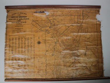 Bendigo Historical Society Inc.
Map - Map of Bendigo streets
... History House 11 Mackenzie Street Bendigo goldfields Situated at Cowlings Ford Dealership and Garage in Bendigo to enable employees to find streets from 1930 to 1970 when Cowlings closed. Eaglehawk Map Cowlings Garage Bendigo Paper on canvas wall map. Street and Road map of City of Greater Bendigo, Borough of Eaglehawk and Surrounding Districts. Wooden hanging rod on top edge. Wooden rod on lower edge has detached. Light brown background. Printed in black and red. Includes Street indexes, historical information and key to points of interest ...Situated at Cowlings Ford Dealership and Garage in Bendigo to enable employees to find streets from 1930 to 1970 when Cowlings closed.Paper on canvas wall map. Street and Road map of City of Greater Bendigo, Borough of Eaglehawk and Surrounding Districts. Wooden hanging rod on top edge. Wooden rod on lower edge has detached. Light brown background. Printed in black and red. Includes Street indexes, historical information and key to points of interest.eaglehawk, map, cowlings garage bendigo -
Bendigo Historical Society Inc.
Map - Bendigo, Eaglehawk
... History House 11 Mackenzie Street Bendigo goldfields Eaglehawk Map Paper on canvas wall map. Street and Road map of City of Greater Bendigo, Borough of Eaglehawk and Surrounding Districts. Wooden hanging rod on top edge. Plastic rod on lower edge. Light brown background. Two hanging tapes at centre of top hanging rod. Printed in black and red. Includes Street indexes, historical information and key to points of interest ...Paper on canvas wall map. Street and Road map of City of Greater Bendigo, Borough of Eaglehawk and Surrounding Districts. Wooden hanging rod on top edge. Plastic rod on lower edge. Light brown background. Two hanging tapes at centre of top hanging rod. Printed in black and red. Includes Street indexes, historical information and key to points of interest.eaglehawk, map -
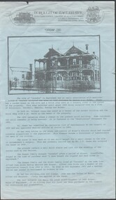 Bendigo Historical Society Inc.
Flyer - Eaglehawk Heritage Society leaflets
... History House 11 Mackenzie Street Bendigo goldfields historic points of interest within Eaglehawk Map of points of historic interest within Eaglehawk Trifold leaflet black print on blue paper, includes map of the Borough and "places of Interest". ...Trifold leaflet black print on blue paper, includes map of the Borough and "places of Interest". Includes history of the house "Caradon".historic points of interest within eaglehawk, map of points of historic interest within eaglehawk -
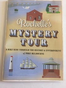 Port Melbourne Historical & Preservation Society
Pamphlet - Rochelle's Mystery Tour, bicycle tour of Port Melbourne identifying historic locations, Rochelle BELL, Rochelle's Mystery Tour, Jan 2017
... Port Melbourne Historical & Preservation Society Port Melbourne Town Hall 333 Bay Street Port Melbourne melbourne Built Environment Recreation Social Activities Celebrations Fetes and Exhibitions Piers and Wharves - Princes Pier Piers and Wharves - Station Pier Rochelle BELL Social Health Inclusion Program (SHIP) Danielle McCAFFREY Centenary Bridge Natural Environment - Beaches and Foreshore Band Rotunda Westgate Park Lagoon Reserve Liardet Community Centre Sandridge Trugo Club Garden City Rochelle's Mystery Tour a ride through the history and environment of Port Melbourne Coloured 4 fold pamphlet with map, photographs of historic bike tour through Port Melbourne. Inside is large map marked with points of interest ...Coloured 4 fold pamphlet with map, photographs of historic bike tour through Port Melbourne. Inside is large map marked with points of interest corresponding to photo and information on reverse sideRochelle's Mystery Tour a ride through the history and environment of Port Melbournebuilt environment, recreation, social activities, celebrations fetes and exhibitions, piers and wharves - princes pier, piers and wharves - station pier, rochelle bell, social health inclusion program (ship), danielle mccaffrey, centenary bridge, natural environment - beaches and foreshore, band rotunda, westgate park, lagoon reserve, liardet community centre, sandridge trugo club, garden city -
 Bendigo Historical Society Inc.
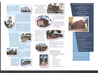
Document - EAGLEHAWK HERITAGE SOCIETY INC BROCHURE
... Coloured brochure which contains a brief history of Eaglehawk, opening times for the Museum, a map with points of interest, application for Membership form, a brief history of the Museum, where Publications can be obtained and Research and Displays....History House 11 Mackenzie Street Bendigo goldfields Eaglehawk Heritage Society Inc Brochure Former Eaglehawk Court House Log Lock Up Eaglehawk Borough Council City of Greter Bendigo Court of Petty Sessions Eaglehawk Newsagency Eaglehawk Post Office Coloured brochure which contains a brief history of Eaglehawk, opening times for the Museum, a map with points of interest, application for Membership form, a brief history of the Museum, where Publications can be obtained and Research and Displays. ...Coloured brochure which contains a brief history of Eaglehawk, opening times for the Museum, a map with points of interest, application for Membership form, a brief history of the Museum, where Publications can be obtained and Research and Displays.eaglehawk heritage society inc brochure, former eaglehawk court house, log lock up, eaglehawk borough council, city of greter bendigo, court of petty sessions, eaglehawk newsagency, eaglehawk post office -
Glenelg Shire Council Cultural Collection
Map - Fold-out Tourist Map of Portland and District, n.d
... Glenelg Shire Council Cultural Collection History House Cliff Street Portland great-ocean-road Black and white fold-out map of Portland District. reverse has maps of Portland and Mt. Gambier, plus tourist information about points of interest ...Black and white fold-out map of Portland District. reverse has maps of Portland and Mt. Gambier, plus tourist information about points of interest in both towns. When folded, photo of Cape Nelson lighthouse on front. -
Glenelg Shire Council Cultural Collection
Map - Map - RACV Portland District Map, Portland, Victoria & Mt Gambier, South Australia, c. 1970
... Glenelg Shire Council Cultural Collection History House Cliff Street Portland great-ocean-road RACV map, black and white tri-fold, photo of Cape Nelson lighthouse on front. When unfolded, map of Portland District on one side, map of Portland and Mt. Gambier on the other, together, with short description and a list of points of interest ...RACV map, black and white tri-fold, photo of Cape Nelson lighthouse on front. When unfolded, map of Portland District on one side, map of Portland and Mt. Gambier on the other, together, with short description and a list of points of interest -
 Sunshine and District Historical Society Incorporated
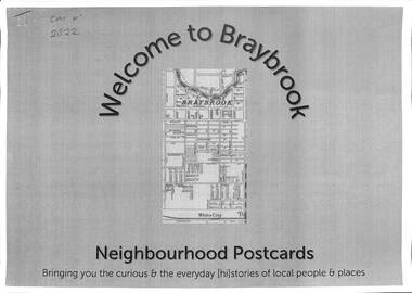
Document - Welcome to Neighbourhood Braybrook Postcards, History At Work Pty Ltd, 2021
... histories of local people whose lives, play, work and pre-occupation have shaped our local communities today. This set features Braybrook, a suburb of Shire of Braybrook and City of Sunshine, prior to the Council mergers in 1996, which created the City of Brimbank. A walking tour map is included that allows one to visit the various points of interest...histories of local people whose lives, play, work and pre-occupation have shaped our local communities today. This set features Braybrook, a suburb of Shire of Braybrook and City of Sunshine, prior to the Council mergers in 1996, which created the City of Brimbank. A walking tour map is included that allows one to visit the various points of interest ...History at Work produced a number of Neighbourhood Postcards of various sites throughout Victoria. Neighbourhood Postcards probes the memories of our local streets for histories of local people whose lives, play, work and pre-occupation have shaped our local communities today. This set features Braybrook, a suburb of Shire of Braybrook and City of Sunshine, prior to the Council mergers in 1996, which created the City of Brimbank. A walking tour map is included that allows one to visit the various points of interest featured in the postcards including The Munition Workers Housing Estate, The basalt plains of the west, Solomon's Ford, Quang Minh Temple, The animal by-products industry, Braybrook Radio Broadcasting Station, Peanut Butter Factory (ETA), Yvonne Barrett Australian Pop Singer, The Marin baluk, Melon Street, Doug Hawkins AFL Champion and Tottenham RAAF.Welcome to Neighbourhood Braybrook Postcards Bringing you the curious & everyday history of local people and placesbraybrook, munition workers housing estate, solomon's ford, quang minh temple, braybrook radio broadcasting station, peanut butter factory, eta, yvonne barrett, marin baluk, melon street, doug hawkins, les twentyman, alfred ravenhall, raaf no 1 store, myalla street, braybrook salvation army hall, darnley street, kingsford street, carlton street, joseph solomon -
Clunes Museum
Pamphlet, Clunes Historic Gold Town Victoria
... Text outlines the history of Clunes and depicts points of interest with map of area on back. .2 Foolscap brochure folded in 4, coloured and black and white photos of Clunes. ...Text outlines the history of Clunes and depicts points of interest with map of area on back. .2 Foolscap brochure folded in 4, coloured and black and white photos of Clunes. ....1 Foolscap brochure folded in 4, coloured and black and white photos of Clunes. Text outlines the history of Clunes and depicts points of interest with map of area on back. .2 Foolscap brochure folded in 4, coloured and black and white photos of Clunes. Text outlines the history of Clunes and depicts points of interest with map of area on back.clunes gold town, clunes attractions, clunes history -
Koorie Heritage Trust
Booklet, Bremner, G.A, A Tour Brochure of Kyneton and District : with historical background, 1973
... A general outline of some of the history of the area together with a map and guide to points of interest. 24 p. : maps. ; 21 cm. ...A general outline of some of the history of the area together with a map and guide to points of interest.24 p. : maps. ; 21 cm.A general outline of some of the history of the area together with a map and guide to points of interest.local history -- kyneton. -
 Melbourne Tram Museum
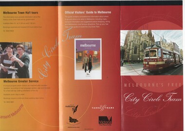
Pamphlet, Department of Infrastructure (DOI), "Melbourne's Free City Circle Tram", 2005
... map shows various points, the Golden Mile heritage walk. Has the Victoria government, City of Melbourne and Yarra Trams logos. Provides information on the points of interest and the Visitor Centre. Gives a short history...map shows various points, the Golden Mile heritage walk. Has the Victoria government, City of Melbourne and Yarra Trams logos. Provides information on the points of interest and the Visitor Centre. Gives a short history ...Pamphlet - folded to DL size, 8 fold, titled "Melbourne's Free City Circle Tram" and on rear "Official Visitors Guide to Melbourne". Details the City Circle tram, c2005 - has route via Harbour Esplanade - map shows various points, the Golden Mile heritage walk. Has the Victoria government, City of Melbourne and Yarra Trams logos. Provides information on the points of interest and the Visitor Centre. Gives a short history of Melbourne's tram and has a photo of V214 See Reg Items 1199, 866 and 2993 for other versions.trams, tramways, city circle, yarra trams, docklands, tram 856, tram 888, tram 214, tram 3004