Showing 3 items matching "hylton crescent"
-
 Whitehorse Historical Society Inc.
Map, Husband Road, Forest Hill, 1972
... ...Hylton Crescent...Whitehorse Historical Society Inc. 2-10 Deep Creek Road Mitcham melbourne Canterbury Road Forest Hill Husband Road Forest Hill Hylton Crescent Forest Hill Sapphire Street Forest Hill Opal Street Forest Hill Amber Street Forest Hill Willurah Street Forest Hill Nunawading Swimming Pool Aerial photographs Nunawading Memorial Swimming Pool Nunawading pool Aqualink Nunawading Enlarged aerial photo of area between Canterbury and Husband Roads Forest Hill. ...Enlarged aerial photo of area between Canterbury and Husband Roads Forest Hill. Melbourne, 1972Enlarged aerial photo of area between Canterbury and Husband Roads Forest Hill. Melbourne, 1972Enlarged aerial photo of area between Canterbury and Husband Roads Forest Hill. Melbourne, 1972canterbury road, forest hill, husband road, forest hill, hylton crescent, forest hill, sapphire street, forest hill, opal street, forest hill, amber street, forest hill, willurah street, forest hill, nunawading swimming pool, aerial photographs, nunawading memorial swimming pool, nunawading pool, aqualink nunawading -
 Ringwood and District Historical Society
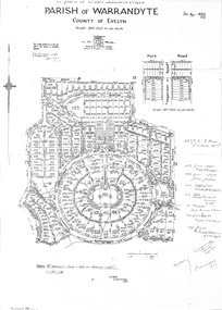
Document - Subdivision Map, Part of Crown Sections 18, 19, 24 & 25, Parish of Warrandyte, County of Evelyn, Vol 5228 Fol 472 - 1926. (Park Orchards, Victoria)
... Map includes Valley Road, Granard Avenue, Park Road, Arundel Avenue, Hylton Avenue, Aviemore Avenue, Bowmore Avenue, Hopetoun Road, Colin Avenue, Daintree Avenue, Brucedale Crescent, Feversham Avenue, Ennismore Crescent, Iona Grove, Elgin Crescent and Gosford Crescent, Park Orchards, Victoria....Ringwood and District Historical Society 125A Warrandyte Road Ringwood North melbourne Map includes Valley Road, Granard Avenue, Park Road, Arundel Avenue, Hylton Avenue, Aviemore Avenue, Bowmore Avenue, Hopetoun Road, Colin Avenue, Daintree Avenue, Brucedale Crescent, Feversham Avenue, Ennismore Crescent, Iona Grove, Elgin Crescent and Gosford Crescent, Park Orchards, Victoria. ...A3 and A4 sized photocopies showing map section of land title showing streets, easements and allotment numbers, some with handwritten names and pricing notations circa mid 1950s.Map includes Valley Road, Granard Avenue, Park Road, Arundel Avenue, Hylton Avenue, Aviemore Avenue, Bowmore Avenue, Hopetoun Road, Colin Avenue, Daintree Avenue, Brucedale Crescent, Feversham Avenue, Ennismore Crescent, Iona Grove, Elgin Crescent and Gosford Crescent, Park Orchards, Victoria. -
 Ringwood and District Historical Society
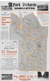
Map, Park Orchards Land Sale Advertisement, Doncaster, Victoria, Circa 1926
... Subdivision includes Alva Avenue, Arundel Road, Aviemore Avenue, Berringa Road, Bowmore Avenue, Brucedale Crescent, Brympton Avenue, Camber Avenue, Cawdor Avenue, Colin Avenue, Corriedale Crescent, Craithie Avenue, Daintree Avenue, Dalry Avenue, Dirlton Crescent, Drayton Crescent, Elgin Crescent, Enfield Avenue, Ennismore Crescent, Euston Avenue, Feversham Avenue, Frogmore Crescent, Gosford Crescent, Granard Avenue, Hopetoun Road, Hylton Avenue (later Knees Road), Jura Avenue, Park Road....Ringwood and District Historical Society 125A Warrandyte Road Ringwood North melbourne Subdivision includes Alva Avenue, Arundel Road, Aviemore Avenue, Berringa Road, Bowmore Avenue, Brucedale Crescent, Brympton Avenue, Camber Avenue, Cawdor Avenue, Colin Avenue, Corriedale Crescent, Craithie Avenue, Daintree Avenue, Dalry Avenue, Dirlton Crescent, Drayton Crescent, Elgin Crescent, Enfield Avenue, Ennismore Crescent, Euston Avenue, Feversham Avenue, Frogmore Crescent, Gosford Crescent, Granard Avenue, Hopetoun Road, Hylton Avenue (later Knees Road), Jura Avenue, Park Road. ...Large linen backed map of the Park Orchards subdivision for private sale of residential sites and recreation club, highlighting local facilities, services and layout of the estate. Surveyors - Tuxen & Miller, 34 Queen Street, Melbourne. Agents - Wm Addey & Co., Pty Ltd., National Mutual Buildings, 395 Collins Street, Melbourne, Phone F3906. Terms £5 deposit balance monthly installments of £1 with the residue at the end of five years. Subdivision includes Alva Avenue, Arundel Road, Aviemore Avenue, Berringa Road, Bowmore Avenue, Brucedale Crescent, Brympton Avenue, Camber Avenue, Cawdor Avenue, Colin Avenue, Corriedale Crescent, Craithie Avenue, Daintree Avenue, Dalry Avenue, Dirlton Crescent, Drayton Crescent, Elgin Crescent, Enfield Avenue, Ennismore Crescent, Euston Avenue, Feversham Avenue, Frogmore Crescent, Gosford Crescent, Granard Avenue, Hopetoun Road, Hylton Avenue (later Knees Road), Jura Avenue, Park Road.