Showing 58 items matching "irrigation settlement"
-
 Ballarat Heritage Services
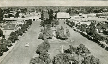
Image - Black and White, Leeton Irrigation Settlement, c1950, c1950
... Leeton Irrigation Settlement, c1950...A black and white image of a wide street in Leeton Irrigation Settlement....Leeton Irrigation Settlement, New South Wales, Australia...Ballarat Heritage Services PO Box 2209 Bakery Hill Post Office goldfields corowa customs house river bridge A black and white image of a wide street in Leeton Irrigation Settlement. Leeton Irrigation Settlement, c1950 Image - Black and White ...A black and white image of a wide street in Leeton Irrigation Settlement.corowa, customs house, river, bridge -
 Bendigo Historical Society Inc.
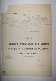
Map - BENDIGO IRRIGATION SETTLEMENT, 20/10/1908
... BENDIGO IRRIGATION SETTLEMENT......irrigation settlement...Map: Bendigo Irrigation Settlement, Parishes of Sandhurst and Wellsford, County of Bendigo, Parish plan...History House 11 Mackenzie Street Bendigo goldfields MAP Bendigo irrigation settlement Bendigo irrigation Settlement Map: Bendigo Irrigation Settlement, Parishes of Sandhurst and Wellsford, County of Bendigo, Parish plan Map BENDIGO IRRIGATION SETTLEMENT ...Map: Bendigo Irrigation Settlement, Parishes of Sandhurst and Wellsford, County of Bendigo, Parish planmap, bendigo, irrigation settlement, bendigo irrigation settlement -
 Bendigo Historical Society Inc.
Map - BENDIGO IRRIGATION SETTLEMENT, 12/02/1908
... BENDIGO IRRIGATION SETTLEMENT......irrigation settlement...Map: Plan of Bendigo Irrigation Settlement, Parishes of Sandhurst and Wellsford, County of Bendigo ( number 160 in Map Cupboard 1)...History House 11 Mackenzie Street Bendigo goldfields MAP Bendigo irrigation settlement Bendigo Irrigation Settlement Parishes of Sandhurst and Wellsford County of Bendigo Map: Plan of Bendigo Irrigation Settlement, Parishes of Sandhurst and Wellsford, County of Bendigo ( number 160 in Map Cupboard 1) Map BENDIGO IRRIGATION SETTLEMENT ...Map: Plan of Bendigo Irrigation Settlement, Parishes of Sandhurst and Wellsford, County of Bendigo ( number 160 in Map Cupboard 1)map, bendigo, irrigation settlement, bendigo irrigation settlement, parishes of sandhurst and wellsford, county of bendigo -
Bendigo Historical Society Inc.
Map - BENDIGO WEST IRRIGATION SETTLEMENT, 27/07/1910
... BENDIGO WEST IRRIGATION SETTLEMENT......irrigation settlement...Map: bendigo West Irrigation Settlement, Parish of Sandhurst, County of Bendigo. ...History House 11 Mackenzie Street Bendigo goldfields MAP Bendigo irrigation settlement Bendigo West Irrigation Settlement Map: bendigo West Irrigation Settlement, Parish of Sandhurst, County of Bendigo. ...Map: bendigo West Irrigation Settlement, Parish of Sandhurst, County of Bendigo. Parish plan ( number 193 in Map Cupboard 1)map, bendigo, irrigation settlement, bendigo west irrigation settlement -
Bendigo Historical Society Inc.
Map - BENDIGO WEST IRRIGATION SETTLEMENT, 13/02/1909
... BENDIGO WEST IRRIGATION SETTLEMENT......irrigation settlement...Map: Bendigo West Irrigation Settlement, Parish of Sandhurst, County of Bendigo. ...History House 11 Mackenzie Street Bendigo goldfields MAP Bendigo irrigation settlement Bendigo West Irrigatioon Settlement Map: Bendigo West Irrigation Settlement, Parish of Sandhurst, County of Bendigo. ...Map: Bendigo West Irrigation Settlement, Parish of Sandhurst, County of Bendigo. Parish plan. ( number 191 in Map Cupboard 1)map, bendigo, irrigation settlement, bendigo west irrigatioon settlement -
 Tatura Irrigation & Wartime Camps Museum
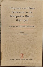
Book - Irrigation and Closer Settlement in the Shepparton District 1836 - 1906, Colin Swinburne Martin
... Irrigation and Closer Settlement in the Shepparton District 1836 - 1906...Irrigation and Closer Settlement in the Shepparton District 1836 - 1906...irrigation and closer settlement around Shepparton district...There are brown marks inside the cover that indicate it was taped down at some stage in it's life Irrigation and Closer Settlement in the Shepparton District 1836 - 1906 Book Irrigation and Closer Settlement in the Shepparton District 1836 - 1906 Colin Swinburne Martin ...Green hardvocer with very dark cream wrap around cover, with black and read writing , front fly leaf has description of contents. Stamped inside is Churchlands Teachers college library, Pearson St, Churchlands, Western Australia 6018. Same stamp is also on back page of book. There are brown marks inside the cover that indicate it was taped down at some stage in it's lifenon-fictionirrigation and closer settlement around shepparton district, mcallister, colin swinburne martin -
Merbein District Historical Society
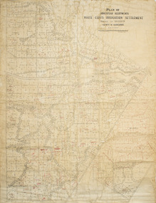
Map, White Cliffs Irrigation Settlement - Plan of Homestead Allotments, 1917
... White Cliffs Irrigation Settlement - Plan of Homestead Allotments...... Irrigation settlement...Merbein District Historical Society 36 Box St Merbein the-murray Homestead allotments Parish of Merbein County of Karkarooc Blocks Irrigation settlement White Cliffs Irrigation Settlement - Plan of Homestead Allotments Map ...homestead allotments, parish of merbein, county of karkarooc, blocks, irrigation settlement -
Tatura Irrigation & Wartime Camps Museum
Book - Folder, Eschol Irrigation Settlement 1893 Book 2, 1985
... Eschol Irrigation Settlement 1893 Book 2...Eschol Irrigation Settlement information including maps, business directory 1893. ...Tatura Irrigation & Wartime Camps Museum 49 Hogan Street Tatura the-murray Eschol Irrigation Settlement information including maps, business directory 1893. ...Eschol Irrigation Settlement information including maps, business directory 1893. Book 2Black A5 plastic folder, white label, blue writing on front. 20 plastic sleeves.inside front cover: Donor Tom Flanagan Tatura 9.8.1985irrigation, documents, newspapers, eschol irrigation -
Tatura Irrigation & Wartime Camps Museum
Book - Folder, Eschol Irrigation Settlement 1893 Book 1, 1985
... Eschol Irrigation Settlement 1893 Book 1...A scheme for more agricultural settlements from irrigation areas....Contains 20 plastic sleeves. Eschol Irrigation Settlement 1893 Book 1 Book Folder ...Eschol Irrigation Settlement Prospectus, 1893. Original document photocopied by David Carrol, Tatura Research Station. A scheme for more agricultural settlements from irrigation areas.Black A5 folder with white printed label on front. Title on spine. Contains 20 plastic sleeves.inside cover: white label: Donor Tom Flanagan, Hogan Street Tatura 9.8.1985irrigation, document, eschol irrigation, david carrol, tatura research station -
 Ballarat Heritage Services
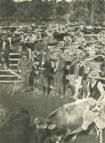
Photograph - Image - Black and White, Stockyard at the Cattlesales, Northern Territory, c1950, c1950
... Leeton Irrigation Settlement, New South Wales, Australia ...A black and white image of cattle for sale in the Northern Territory. cattle, cattlesales, farming, northern territory -
Merbein District Historical Society
Book, Merbein Glimpses into the Fifty Years as an Irrigation Settlement, Mar.2009
... Merbein Glimpses into the Fifty Years as an Irrigation Settlement...Merbein District Historical Society 36 Box St Merbein the-murray Bernadette Wells White Cliffs Blandowski Land Allottments Pumping Station Merbein Football Club Recreation Town Allotments Businesses Schools Merbein Soldiers Kenny Park Memorial Pillars The Common Merbein Halls Flood 1956 50th Anniversary Parade Merbein Glimpses into the Fifty Years as an Irrigation Settlement Book ...bernadette wells, white cliffs, blandowski, land allottments, pumping station, merbein football club, recreation, town allotments, businesses, schools, merbein soldiers, kenny park, memorial pillars, the common, merbein halls, flood 1956, 50th anniversary parade -
 Merbein District Historical Society
Plan - Plan, Allotments, Plan of Homestead Allotments White Cliffs Irrigation Settlement Parish of Merbein County of Karkarooc
... Plan of Homestead Allotments White Cliffs Irrigation Settlement Parish of Merbein County of Karkarooc...Some red ink added Plan of Homestead Allotments White Cliffs Irrigation Settlement Parish of Merbein County of Karkarooc Plan Plan, Allotments ...Large plan drawn in black ink on cream colour paper with linen backing. Some red ink addedWritten in red pen new owners of allotmentsallotments, merbein, irrigation, whitecliffs, county of karkarooc -
Merbein District Historical Society
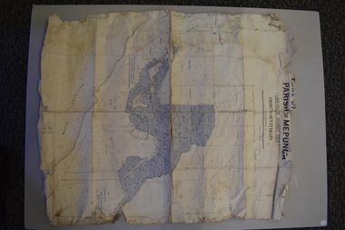
Map, White Cliffs Irrigation Settlement - Plan of Homestead Allotments, 1917
... White Cliffs Irrigation Settlement - Plan of Homestead Allotments...Merbein District Historical Society 36 Box St Merbein the-murray Blocks Irrigation Parish of Merbein Homestead Allotments White Cliffs Irrigation Settlement - Plan of Homestead Allotments Map ...blocks, irrigation, parish of merbein, homestead allotments -
Merbein District Historical Society
Book, Diamond Jublilee/Our Lady/Sacred Heart Primary School Merbein No1277, 1928-1988
... ... Merbein Irrigation Settlement...Merbein District Historical Society 36 Box St Merbein the-murray Schools Education Our Lady of the Sacred Heart Primary School Primary Schools Catholic Church Merbein Irrigation Settlement Edward Joseph Kenny Diamond Jublilee/Our Lady/Sacred Heart Primary School Merbein No1277 Book ...schools, education, our lady of the sacred heart primary school, primary schools, catholic church, merbein irrigation settlement, edward joseph kenny -
 Merbein District Historical Society
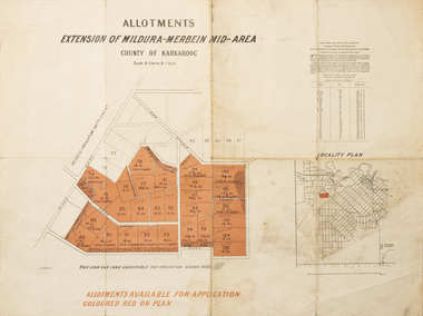
Map - Allotments Extension of Mildura-Merbein Mid-Area, Allotments available, 23 November 1920
... ...Soldier Settlement...Irrigation...Merbein District Historical Society 36 Box St Merbein the-murray Allotments available to Discharged Soldiers Discharged Soldier's Settlement Act Historic Discharged Soldiers WW1 Soldier Settlement Irrigation Photo-Lithographed at Department of lands Survey, Melbourne J. ...Allotments available to Discharged Soldiers Discharged Soldier's Settlement Act Historic Large map, folded in 4, coloured map of Merbein indicating allotments available and locality plan. Scale 10 chain to 1 inchPhoto-Lithographed at Department of lands Survey, Melbourne J. Butson 23.11.20discharged soldiers, ww1, soldier settlement, irrigation -
 Bendigo Historical Society Inc.
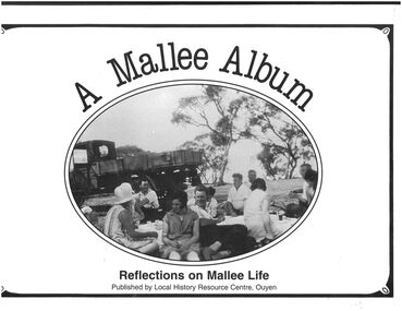
Book - "A Mallee Album. Reflections on Mallee Life.", 1988
... In 1903 the railway line was extended from Woomelang (80 km south of Ouyen) to Mildura, the site of an irrigation settlement on the Murray River. The prospect of farming in the Mallee had been enhanced by settlements at Hopetoun and Lascelles (both near Woomelang), and the opening of the railway line invited settlement along its route. ...In 1903 the railway line was extended from Woomelang (80 km south of Ouyen) to Mildura, the site of an irrigation settlement on the Murray River. The prospect of farming in the Mallee had been enhanced by settlements at Hopetoun and Lascelles (both near Woomelang), and the opening of the railway line invited settlement along its route. ...Ouyen is a rural township near the centre of the Mallee region in north-west Victoria. It is on the Sunraysia Highway, 100 km south of Mildura, and is a railway junction for the lines to Mildura and westwards through the Mallee to Murrayville and Pinnaroo, South Australia. In 1903 the railway line was extended from Woomelang (80 km south of Ouyen) to Mildura, the site of an irrigation settlement on the Murray River. The prospect of farming in the Mallee had been enhanced by settlements at Hopetoun and Lascelles (both near Woomelang), and the opening of the railway line invited settlement along its route. Settlers began arriving in the Ouyen district in 1906, and the township was proclaimed in 1909. It is thought that the name was derived from an Aboriginal word meaning ghost or waterhole. West of Ouyen an area of land extending to the South Australian border was found to be adequate for farming and contained bore water (1906). Settlement spread westwards from about 1909 to Walpeup and beyond. Ouyen began functioning as a service centre. A school was opened in 1909 in a coffee palace and public hall. Within 15 years of its settlement Ouyen had 900 people, and was the administrative centre of Walpeup shire (1911). A shire hall was built in 1918. A district hospital was built in 1929, and a higher education school was opened in 1928. It became a high school in 1952. A Catholic primary school was also opened in 1952. By the 1930s, though, Ouyen had a local court, four banks, an agricultural society, sporting and racing clubs, and local industries such as cordial making, plaster sheet, a freezing works and an electricity generation plant. Silos were later built for the storage and railing of cereal grains."A Mallee Album. Reflections on Mallee Life" published by Local History Resource Centre, Ouyen. Foreword by The Local History Resource Centre Committee, Ouyen. A collection of images from the area and brief description associated with each image. Published in Australia by Local History Resource centre, Ouyen, 1988. White colored hard cover book. Black and white photograph on front cover. Titles printed in black. Book includes black and white photographs of local people and events. 153 pp.mallee, ouyen -
 Warrnambool and District Historical Society Inc.
Map - Maps, Soldiers Settlement WW2, Circa 1950
... As such they have historic and social interest and significance. narrapumelap berrambool hopkins hill caramut north morpor chatsworth house east elwood terrinallum moyne falls tarrone caramut soldiers settlers Burrumbeet morgiana grey's estate mornington chaldon meade brung brungle The maps are as follows: .1 Narrapumelap Estate ( Ripon & Hampden) .2 Narrapumelap Estate Part 2 (Villers & Ripon) .3 Narrapumelap Estate Part 3 ( Villiers & Ripon) .4 Burrumbeet Estate ( Ripon) .5 ' Berrambool' Estate 9 Hampden & Villiers) .6 ' Hopkins Hill' Estate Villiers 4011 acres .7 Caramut North No 2 Estate ( Villiers ) .8 ' Morpor' Estate ( Villiers) 4172 acres .9 ' Morgiana' Estate ( Normandy) 3453 acres .10 ' Chatsworth House' ( Villiers) 9341 Acres .11 ' East Elwood' Estate Villiers 2407 acres .12 Grey's Estate ( Mornington) 1151acres .13 ' Rowes Estate' ( Buln Buln Gippsland 733 acres .14 'Tarrone' Estate No 2 Part map .15 'Chaldon Meade' Estate (Bourke) Bulla 517 acres .16 ' Terranallum South' Estate Hampden 3757 acres .17 ' Brung Brungle' Estate Dundas 695 .18 ' Armidale ' Estate ( Dundas)2108 acres .19 ' Moyne Falls' Estate ( Villiers) 627 acres .20' Yulong' Estate 9 Lowan 6321 acres .21 Murray Valley Irrigation District 9 Moira)113 acres .22 Murray Valley Irrigation District 103 acres .23 ' Mount Fyans' Estate ( Hampden) .24 ' Barwidgee ' Estate ( Villiers) 4277 acres .25 'Pine Hills' Estate 2nd portion ( Lowan) 6190 acres A collection of 25 paper maps which relate to to the soldiers settlement post World War 2. ...The soldiers' settlement scheme operated after the first and second world wars in an effort to more closely settle the land and also give opportunities to returned soldiers. Crown land and other larger estates were acquired for the purpose. Most of these maps relate to the area north of Warrnambool where many of the subdivisions were parts of larger estates.These maps pertaining to the Soldiers' Settlement program, relate to an interesting part of Australian and local history. As such they have historic and social interest and significance.A collection of 25 paper maps which relate to to the soldiers settlement post World War 2. Some have details of the people allocated the land and some smaller maps have the printed details of the applicants requirements.Text is black on white paper which in some cases is quite aged. The maps are as follows: .1 Narrapumelap Estate ( Ripon & Hampden) .2 Narrapumelap Estate Part 2 (Villers & Ripon) .3 Narrapumelap Estate Part 3 ( Villiers & Ripon) .4 Burrumbeet Estate ( Ripon) .5 ' Berrambool' Estate 9 Hampden & Villiers) .6 ' Hopkins Hill' Estate Villiers 4011 acres .7 Caramut North No 2 Estate ( Villiers ) .8 ' Morpor' Estate ( Villiers) 4172 acres .9 ' Morgiana' Estate ( Normandy) 3453 acres .10 ' Chatsworth House' ( Villiers) 9341 Acres .11 ' East Elwood' Estate Villiers 2407 acres .12 Grey's Estate ( Mornington) 1151acres .13 ' Rowes Estate' ( Buln Buln Gippsland 733 acres .14 'Tarrone' Estate No 2 Part map .15 'Chaldon Meade' Estate (Bourke) Bulla 517 acres .16 ' Terranallum South' Estate Hampden 3757 acres .17 ' Brung Brungle' Estate Dundas 695 .18 ' Armidale ' Estate ( Dundas)2108 acres .19 ' Moyne Falls' Estate ( Villiers) 627 acres .20' Yulong' Estate 9 Lowan 6321 acres .21 Murray Valley Irrigation District 9 Moira)113 acres .22 Murray Valley Irrigation District 103 acres .23 ' Mount Fyans' Estate ( Hampden) .24 ' Barwidgee ' Estate ( Villiers) 4277 acres .25 'Pine Hills' Estate 2nd portion ( Lowan) 6190 acres narrapumelap, berrambool, hopkins hill, caramut north, morpor, chatsworth house, east elwood, terrinallum, moyne falls, tarrone, caramut soldiers settlers, burrumbeet, morgiana, grey's estate mornington, chaldon meade, brung brungle -
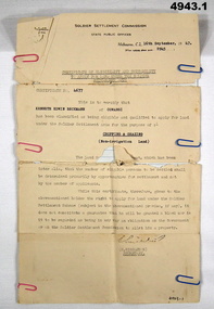 Bendigo Military Museum
Certificate, Certificate of eligibility and suitability for soldier settlement
... Settlement Commission. State Public Offices. Tel F 0234. Dated Melb 16 Sep 1947. Letter No 8945. In the text is Cert No. 4677 for Kenneth Edwin Beckman of Cowangi. The purpose of the land is for cropping and grazing (non irrigation...Settlement Commission. State Public Offices. Tel F 0234. Dated Melb 16 Sep 1947. Letter No 8945. In the text is Cert No. 4677 for Kenneth Edwin Beckman of Cowangi. The purpose of the land is for cropping and grazing (non irrigation ...1. Foolscap size sheet (see condition) Letterhead is for the soldier Settlement Commission. State Public Offices. Tel F 0234. Dated Melb 16 Sep 1947. Letter No 8945. In the text is Cert No. 4677 for Kenneth Edwin Beckman of Cowangi. The purpose of the land is for cropping and grazing (non irrigation land) 2. Letter quarto size paper. Letterhead of Australian Mil Forces. Tel No. M 45966 Ext 30. Victoria Echelon and records 291 Lonsdale St Melbourne dated 2 Nov 1945. In the text is printed EX V64354 K E Beckman. Cert of Discharge 294425. RAS Badge No. A 99448. Will (AAF A.131) One..admin record, ww2 -
University of Melbourne, Burnley Campus Archives
Document - Newspaper Cutting, The Mildura Cultivator 1896 Mildura Royal Commission Findings and Recommendations 1896
... Recommedation of loan to be granted to keep the settlement going - to be spent on irrigation works....Recommedation of loan to be granted to keep the settlement going - to be spent on irrigation works. The Mildura Cultivator 1896 Mildura Royal Commission Findings and Recommendations 1896 Document Newspaper Cutting ...Part of Sandy Pullman's research notes in C.b. LuffmannOne page photocopy of The Mildura Cultivator September 19, 1896 The Royal Commission on Mildura Affairs. Report and Recommendations. Summary of findings. Recommedation of loan to be granted to keep the settlement going - to be spent on irrigation works.mildura royal commission -
Tatura Irrigation & Wartime Camps Museum
Fence Droppers, late 19th century to early 20th
... Tatura Irrigation & Wartime Camps Museum 49 Hogan Street Tatura the-murray Split timber fence droppers were used with the earliest wire fences especially with closer settlement areas like Tatura. ...Split timber fence droppers were used with the earliest wire fences especially with closer settlement areas like Tatura. The donors family were Tatura hardware and timber merchants so may have made and supplied these to farmers. 3 wooden dropper split with axe to shape rather than sawn. 6 holes for wire to pass through (6 gauge). Used between posts to support wires. Made from straight grained timber, grey box.fence dropper, wood fence dropper, fencing material -
Tatura Irrigation & Wartime Camps Museum
Multi ringed folder, Kaye Watson, Internment camp No 3. Rushworth Migrant camp
... Tatura Irrigation & Wartime Camps Museum 49 Hogan Street Tatura the-murray The camp sites today are on private property, and as they were dismantled after the war, and on the closure of the Migrant camp, very little physical evidence remains today. Camp 3 held 1000 internees, Germans, Jews and Italians, including German Lutheran families from New Guinea, German families from Palestine (Templer settlement ...The camp sites today are on private property, and as they were dismantled after the war, and on the closure of the Migrant camp, very little physical evidence remains today.Camp 3 held 1000 internees, Germans, Jews and Italians, including German Lutheran families from New Guinea, German families from Palestine (Templer settlement) and Austrian Jewish refugees. After the war camp 3 became the first camp for Displaced persons in Victoria, where families could live until work and accommodation was found for them.Many pages, with 12 photos on each page, of scenes showing the remains from camp 3camp 3 rushworth -
Tatura Irrigation & Wartime Camps Museum
Book, Exiled From The Holy Land by Horst Blaich, 2009
... Tatura Irrigation & Wartime Camps Museum 49 Hogan Street Tatura the-murray Tells the story of the loss of the Templer Settlements in Palestine. ...Tells the story of the loss of the Templer Settlements in Palestine. Soft covered book with title in black bold print at top, a picture of "Empire Comfort" on front. 220 pages.With compliments Horst Blaich 2011 (received 2020) on inside page. -
 Tatura Irrigation & Wartime Camps Museum
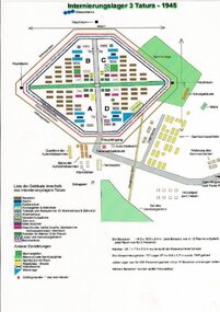
Drawing, Internment Camp 3 Tatura as in 1945, January 1992
... Tatura Irrigation & Wartime Camps Museum 49 Hogan Street Tatura the-murray Plan of Camp 3 Tatura layout as in 1945. Camp contained members of Palestine, Singapore/Straits Settlement & New Guinea Groups. palestine group singapore group new guinea group camp 3 layout Laminated coloured A4 plan showing layout of buildings and perimeter fencing of camp 3 Tatura. ...Plan of Camp 3 Tatura layout as in 1945. Camp contained members of Palestine, Singapore/Straits Settlement & New Guinea Groups.Laminated coloured A4 plan showing layout of buildings and perimeter fencing of camp 3 Tatura. palestine group, singapore group, new guinea group, camp 3 layout -
Tatura Irrigation & Wartime Camps Museum
Book, Waranga 1865 1965 A Shire History, 1965
... Tatura Irrigation & Wartime Camps Museum 49 Hogan Street Tatura the-murray Presentation of day-to-day happenings in Warange district by a member of Soldier-Settlement family. ...Presentation of day-to-day happenings in Warange district by a member of Soldier-Settlement family. Research period 1865-1965Gold dust jacket. 1860 goldfields depicted thereon. Printing in white and red. 147 pagesRon Johnson Hunter. Xmas 1965waranga, forster hw, tatura, books, history, local -
 Tatura Irrigation & Wartime Camps Museum
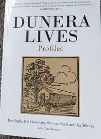
Book, Ken Inglis et al, Dunera Lives Profiles, 1941
... Irrigation & Wartime Camps Museum 49 Hogan Street Tatura the-murray Tells the story of several Dunera Boys, prior, during and after their incarceration in Australia. tells the story of enemy aliens during WW2. Dunera Boys Ken Inglis Bill Gammage Seumas Spark Jay Winter Carol Bunyan HMT Dunera Queen Mary Volume 2 of Dunera Lives follows the paths of a selection of Dunera Boys from their early lives before and during the Nazi years, through their arrival in Britain or the Straits Settlements in search of a safe haven, to their arrest as enemy aliens and subsequent deportation and incarceration in camps in Australia. ...Volume 2 of Dunera Lives follows the paths of a selection of Dunera Boys from their early lives before and during the Nazi years, through their arrival in Britain or the Straits Settlements in search of a safe haven, to their arrest as enemy aliens and subsequent deportation and incarceration in camps in Australia. Then, as free men, they start new lives in many parts of the world.While covered book with black writing. Front: book title, photograph of a camp hut and authors names at bottom; Spine: title and authors; back cover: Photograph of several of the Dunera Boys.non-fictionVolume 2 of Dunera Lives follows the paths of a selection of Dunera Boys from their early lives before and during the Nazi years, through their arrival in Britain or the Straits Settlements in search of a safe haven, to their arrest as enemy aliens and subsequent deportation and incarceration in camps in Australia. Then, as free men, they start new lives in many parts of the world.dunera boys, ken inglis, bill gammage, seumas spark, jay winter, carol bunyan, hmt dunera, queen mary -
Tatura Irrigation & Wartime Camps Museum
Archive Folder (grey), James Brady Family
... Irrigation & Wartime Camps Museum 49 Hogan Street Tatura the-murray Assorted photographs and letters. Annie Hogan, daughter of Thomas and Annie Hogan married James Brady. Lived at 43 Ross Street, Tatura. Annie Hogan Thomas Hogan James Brady grey archival folder containing family photographs and letters, including wedding photograph of Annie and James Brady and letter written by James Brady to family 2 May 1930. Also Comprehensive report of Brady family life from earliest settlement ...Assorted photographs and letters. Annie Hogan, daughter of Thomas and Annie Hogan married James Brady. Lived at 43 Ross Street, Tatura.grey archival folder containing family photographs and letters, including wedding photograph of Annie and James Brady and letter written by James Brady to family 2 May 1930. Also Comprehensive report of Brady family life from earliest settlement 1874, Tatura.annie hogan, thomas hogan, james brady -
Tatura Irrigation & Wartime Camps Museum
Book, Our First Fifty Years 1835-1885, 1835
... Irrigation & Wartime Camps Museum 49 Hogan Street Tatura the-murray History of Victoria. A reproduction of an historical Australian book published in 1835. It depicts Victoria at the end of first 50 years of settlement ...History of Victoria. A reproduction of an historical Australian book published in 1835. It depicts Victoria at the end of first 50 years of settlement.Beige and brown cover. Victorian souvenir edition. Print of a ship in rough seas on front cover. The "Lady Nelson" entering Port Phillip.victorian history -
Tatura Irrigation & Wartime Camps Museum
Folder, Department Conservation and Natural Resources et al, Rushworth Waranga, 2003
... Tatura Irrigation & Wartime Camps Museum 49 Hogan Street Tatura the-murray Report on mines, including Balaclava, extracts from Waranga News. Early happening settlement ...Report on mines, including Balaclava, extracts from Waranga News. Early happening settlement life.Black with metal clips. Labels on spine.rushworth, waranga, balaclava mines -
Tatura Irrigation & Wartime Camps Museum
Book, Shepparton celebrates 150 years of Settlement, 2010
... Irrigation & Wartime Camps Museum 49 Hogan Street Tatura the-murray Presented by the Adviser September 1860 - 2010. Surrounded by photographs of people and events in history over many years, in Shepparton. Photograph of Geoff Dobson, Mayor in 2010. History of Shepparton History of Shepparton Geoff Dobson Shepparton Mayors Title on front cover. back cover - history of Furphy Foundry. Shepparton celebrates 150 years of Settlement ...Presented by the Adviser September 1860 - 2010. Surrounded by photographs of people and events in history over many years, in Shepparton. Photograph of Geoff Dobson, Mayor in 2010. History of SheppartonTitle on front cover. back cover - history of Furphy Foundry.history of shepparton, geoff dobson, shepparton mayors