Showing 7 items matching "john royle"
-
 Narre Warren and District Family History Group
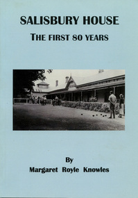
Book, Margaret Royle Knowles, Salisbury House - The first 80 years, 2013
... ...John Royle...Narre Warren and District Family History Group 110 High Street Berwick melbourne Salisbury House upper beaconsfield (vic.) John Royle The first 80 years of Salisbury House, a guesthouse in Upper Beaconsfield, Victoria 69 p.; 26 cm Salisbury House - The first 80 years Book Margaret Royle Knowles ...The first 80 years of Salisbury House, a guesthouse in Upper Beaconsfield, Victoria69 p.; 26 cmnon-fictionThe first 80 years of Salisbury House, a guesthouse in Upper Beaconsfield, Victoriasalisbury house, upper beaconsfield (vic.), john royle -
 Bendigo Military Museum
Photograph - Royal Australian Survey Corps Surveyors in the Field – Project Cutlass, New Guinea, 1956 – 1957
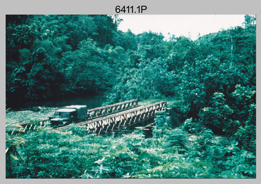
... Royle Bob undertaking survey observations using theodolites from an improvised timber tower, New Ireland. .16) & .17) - Photo, colour, 1957. US Army ship FS216 used for ship-to-shore triangulation docked at Rabaul, New Britain. .18) - Photo, colour, 1957. US Army ship FS216 used for ship-to-shore triangulation docked at Kavieng, New Ireland. Sight target on top of mast. .19) - Photo, colour, 1957. Survey personnel onboard US Army ship FS392, L to R: Peter Frodsham, Bob Thompson, Doc Reid, John...Royle Bob undertaking survey observations using theodolites from an improvised timber tower, New Ireland. .16) & .17) - Photo, colour, 1957. US Army ship FS216 used for ship-to-shore triangulation docked at Rabaul, New Britain. .18) - Photo, colour, 1957. US Army ship FS216 used for ship-to-shore triangulation docked at Kavieng, New Ireland. Sight target on top of mast. .19) - Photo, colour, 1957. Survey personnel onboard US Army ship FS392, L to R: Peter Frodsham, Bob Thompson, Doc Reid, John ...This is a set of 23 photographs of surveyors and support staff in the field undertaking tasks in New Guinea 1956 – 1957. The surveyors were employed in the establishment of mapping and geodetic control for Project Cutlass, the “Ship-Shore” survey of the New Ireland province. In this survey operation surveyors used theodolites to observe horizontal and vertical angles and chains to measure base line distances between survey stations. Bob Skitch shown in photo .7P was in the 2nd year of his career in the Australian Army. He achieved the rank of Lieutenant-Colonel, and his last appointment was the CO of the Army Survey Regiment from 1976 to 1980.This is a set of 23 photographs of surveyors and support staff in the field undertaking duties during Project Cutlass located in New Ireland, New Guinea 1956 – 1957. The photographs were printed on photographic paper and are part of the Army Survey Regiment’s Collection. The photographs were scanned at 300 dpi. .1) - Photo, colour, 1956. Surveyors travelling main road from Kavieng to Namatanai, New Ireland. .2) - Photo, colour, 1956. Unidentified surveyors assessing recovery of their vehicle after bridge collapsed on west side of New Ireland. .3) - Photo, colour, 1956. Unidentified surveyors assessing recovery of their vehicle after bridge collapsed over flooded creek on west side of New Ireland. .4) - Photo, colour, 1956. Survey personnel L to R: Bev Uwins, John Lambie, Bob Thompson, New Ireland. .5) - Photo, colour, 1956. Survey base camp, New Ireland. .6) - Photo, black & white, 1956-1957. Geoff Helsham with possible human remains, New Ireland. .7) - Photo, black & white, 1956-1957. Bob Skitch undertaking survey observations using Wild T2 theodolite, New Ireland. .8) - Photo, black & white, 1956-1957. Chas Beach undertaking survey observations using Wild T2 theodolite, New Ireland. .9) & .10) - Photo, black & white, 1956-1957. Kev Parker (cook) New Ireland. .11) - Photo, colour, 1957. Brian Berkery taking a break, Top Manor Island, Lihir Island Group off New Ireland. Latitude -2° 46”, Longitude 152° 40”. .12) - Photo, colour, 1957. Survey base camp L to R: Chas Beach, Bev Uwins, Feni Islands, New Ireland. Latitude -4° 05”, Longitude 153° 45”. .13) - Photo, colour, 1957. A Hous Kiap. (Kiaps, known formally as district officers and patrol officers, were travelling representatives of the British and Australian governments), New Ireland. .14) & .15) - Photo, colour, 1957. L to R: Joe Farrington, Tom Royle Bob undertaking survey observations using theodolites from an improvised timber tower, New Ireland. .16) & .17) - Photo, colour, 1957. US Army ship FS216 used for ship-to-shore triangulation docked at Rabaul, New Britain. .18) - Photo, colour, 1957. US Army ship FS216 used for ship-to-shore triangulation docked at Kavieng, New Ireland. Sight target on top of mast. .19) - Photo, colour, 1957. Survey personnel onboard US Army ship FS392, L to R: Peter Frodsham, Bob Thompson, Doc Reid, John Underwood, remainder unidentified, New Ireland. .20) - Photo, colour, 1957. Survey base line party heading ashore, New Ireland. .21) - Photo, colour, 1957. Survey personnel rowing US Army assault boat L to R: Kev Parker, Chas Beach, folded up survey beacons overhanging stern, New Ireland. .22) - Photo, colour, 1957. Les Bailey onboard US Army ship departing Rabaul, New Britain for Brisbane. .23) - Photo, colour, 1957. Ron Newman onboard US Army ship departing Rabaul, New Britain for Brisbane. Active volcano in background..1P to .23P annotated on back – ‘Operation Cutlass’, personnel names, the year and the location. royal australian survey corps, rasvy, army survey regiment, fortuna, a, army svy regt, asr, surveying -
 Bendigo Military Museum
Photograph - Royal Australian Survey Corps Surveyors in the Field – North Queensland, 1958
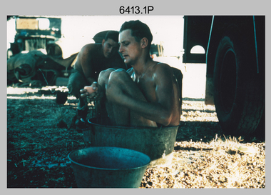
... L to R: John Van De Graff, Bob Skitch, Kev Moody, Mal Hayes, Don Gray .5) - Photo, colour, 1958. Surveyors south of Richmond, QLD erecting a Bilby observation tower. L to R: Tom Royle...L to R: John Van De Graff, Bob Skitch, Kev Moody, Mal Hayes, Don Gray .5) - Photo, colour, 1958. Surveyors south of Richmond, QLD erecting a Bilby observation tower. L to R: Tom Royle ...This is a set of seven photographs of surveyors and support staff in the field undertaking duties in North Queensland in 1958. The surveyors were employed in the establishment of mapping and geodetic control. In this era surveyors used theodolites to observe horizontal and vertical angles and chains to measure base line distances between survey stations. Bob Skitch shown in photos .4P to .6P was in the 2nd year of his career in the Australian Army. He achieved the rank of Lieutenant Colonel and his last appointment was the CO of the Army Survey Regiment from 1976 to 1980. The annotation on the back of photo .5P ‘Black foreground is where Bob Skitch boiled billy and started a grass fire’.This is a set of seven photographs of surveyors and support staff in the field undertaking duties in North Queensland in 1958. The photographs were printed on photographic paper and are part of the Army Survey Regiment’s Collection. The photographs were scanned at 300 dpi. .1) - Photo, colour, 1958. Surveyor in Nth QLD enjoying a bath. L to R: Don Cocker, Bob Thompson. .2) - Photo, colour, 1958. Don Cocker surveyor in Nth QLD, enjoying a bath. .3) - Photo, colour, 1958. Surveyors Nth QLD undertaking survey observations, using MRA1 tellurometer to measure base-line distances. L to R: Len Davies, Lou Sommer, John Van De Graff. MRA1 was covered to stop overheating. .4) - Photo, colour, 1958. Surveyors south of Richmond, QLD digging holes for the erection of a Bilby observation tower. L to R: John Van De Graff, Bob Skitch, Kev Moody, Mal Hayes, Don Gray .5) - Photo, colour, 1958. Surveyors south of Richmond, QLD erecting a Bilby observation tower. L to R: Tom Royle, Bob Skitch (on ground level), Mal Hayes. .6) - Photo, colour, 1958. Surveyors south of Richmond, QLD erecting a Bilby observation tower. L to R: Tom Royle, Bob Skitch, Mal Hayes, Jim McGill (on ground level). .7) - Photo, colour, 1958. Surveyors south of Richmond, QLD undertaking survey measurements from a Bilby observation tower..1P to .7P annotated on back – personnel names, the year and the location. Annotated on back of .5P ‘Black foreground is where Bob Skitch boiled billy and started a grass fire’.royal australian survey corps, rasvy, army survey regiment, asr, army svy regt, fortuna, surveying -
 Bendigo Military Museum
Photograph - Royal Australian Survey Corps Surveyors in the Field – Northern Territory and Queensland, 1959 – 1960
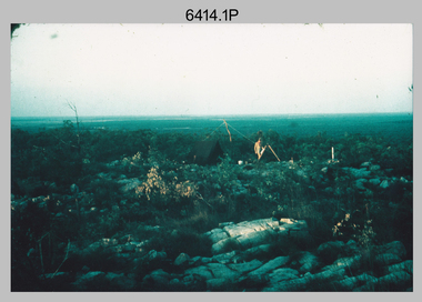
... Royle and Jack McCabe. .5) - Photo, colour, 1959. Survey party taking a break next to their Austin Champ vehicle, in transit between Katherine, NT and Wyndam WA. L to R: Tony Slattery, Dave Owens, John...Royle and Jack McCabe. .5) - Photo, colour, 1959. Survey party taking a break next to their Austin Champ vehicle, in transit between Katherine, NT and Wyndam WA. L to R: Tony Slattery, Dave Owens, John ...This is a set of 10 photographs of surveyors and support staff in the field undertaking duties in the Northern Territory and North Queensland in 1959 – 1960. The surveyors were employed in the establishment of mapping and geodetic control. In this era surveyors used theodolites to observe horizontal and vertical angles and tellurometers to measure base line distances between survey stations. Laplace survey observations seen in Photo .1P was a series of precise observations carried out at geodetic survey stations to determine astronomic latitudes, longitudes and azimuths to achieve maximum precision in the survey network. Laplace observations were necessary in a geodetic network at every 6th survey station, however the National Mapping Council specified at this time the spacing would be ideally between 4-6 survey stations. The cairn shown in photo .4P was built by RASvy as a landmark over a trigonometric survey station. It was dismantled in 1960 to enable re-occupation and survey observations. It was not restored to the condition shown in the photo.This is a set of 10 photographs of surveyors and support staff in the field undertaking duties in the Northern Territory (NT) and Queensland (QLD) in 1959 – 1960. The photographs were printed on photographic paper and are part of the Army Survey Regiment’s Collection. The photographs were scanned at 300 dpi. .1) - Photo, colour, 1959. Tony Slattery occupying a Laplace survey station on a hill in the Mount Young area of the NT. .2) - Photo, colour, 1959. Surveyors’ camp in the Mount Young area of the NT, L to R: Spencer Snow and Tony Slattery. .3) - Photo, colour, 1959. Surveyors’ camp in the Peckman Hill area, near Katherine in the NT. .4) - Photo, colour, 1959. Cairn on Trig Hill, Borroloola, NT. Built by Spencer Snow, Tom Royle and Jack McCabe. .5) - Photo, colour, 1959. Survey party taking a break next to their Austin Champ vehicle, in transit between Katherine, NT and Wyndam WA. L to R: Tony Slattery, Dave Owens, John Van De Graff. .6) - Photo, colour, 1960. Surveyors’ camp between Mount Isa, QLD and Borroloola, NT. L to R: Pat Cox and John Van De Graff prepare their meal on an open fire. .7) - Photo, colour, 1960. Surveyor - Dennis Woods undertaking survey observations, using MRA1 tellurometer to measure base-line distances NW of Mount Isa, QLD. .8) - Photo, colour, 1960. Unidentified surveyors assessing recovery of their stalled Studebaker truck vehicle after attempting a water crossing in the NT. .9) - Photo, colour, 1960. Unidentified surveyor making batches of bread at a camp in the NT. Seen in the photo placing a lid with hot coals onto the camp oven. .10) - Photo, colour, 1960. Unidentified survey party occupying a survey station on a hill in the Mount near the Lawn Hill area, NW of Mount Isa, QLD. A MRA1 tellurometer to measure base-line distances appear on the right side of the photo. .9) - Photo, colour, 1960. Unidentified surveyors assessing recovery of their stalled Studebaker truck vehicle after attempting a water crossing in the NT. .10) - Photo, colour, 1960. Unidentified surveyor making batches of bread at a camp in the NT. Seen in the photo placing a lid with hot coals onto the camp oven. .1P to .10P annotated on back – personnel names, the year and the location. royal australian survey corps, rasvy, army survey regiment, asr, army svy regt, fortuna, surveying -
 Bendigo Military Museum
Photograph - Field Trip Preparations, AHQ Survey Regiment, 1960
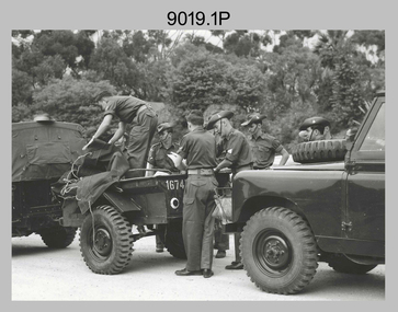
... Other personnel included on the trip, but not exclusively are; Capt Clem Sargent, WO1 Des Moore, WO1 Ron Newman; Sgt Len Davies, Sgt Norm Vaughan, Sgt Joe Farrington (Laplace), Sgt Tony Slattery, Sgt John Van de Graaff (Laplace), Sgt Harry Wright (MT), Sgt Jack Waller (QM) Cpl Lou Sommer, Cpl Bob Skitch (later Sgt), Spr Don Cocker, Spr Ian Bryan, Spr Leo Bub, Spr Bruce Cockburn, Spr Pat Cox, Spr Jim Fitzhenry, Spr Bill Hills, Spr Noel Humphreys, Spr Dennis Woods, Spr Richard Jackson-Hope, Spr Bill Jeffery, Spr Andy Millar, Spr Dave Owen, Spr Blue Rogers, Spr Tom Royle, Spr Bob (Lofty) Thompson, Spr Peter Strandly and Spr Mick Symmons. ...Other personnel included on the trip, but not exclusively are; Capt Clem Sargent, WO1 Des Moore, WO1 Ron Newman; Sgt Len Davies, Sgt Norm Vaughan, Sgt Joe Farrington (Laplace), Sgt Tony Slattery, Sgt John Van de Graaff (Laplace), Sgt Harry Wright (MT), Sgt Jack Waller (QM) Cpl Lou Sommer, Cpl Bob Skitch (later Sgt), Spr Don Cocker, Spr Ian Bryan, Spr Leo Bub, Spr Bruce Cockburn, Spr Pat Cox, Spr Jim Fitzhenry, Spr Bill Hills, Spr Noel Humphreys, Spr Dennis Woods, Spr Richard Jackson-Hope, Spr Bill Jeffery, Spr Andy Millar, Spr Dave Owen, Spr Blue Rogers, Spr Tom Royle, Spr Bob (Lofty) Thompson, Spr Peter Strandly and Spr Mick Symmons. ...Field Trip Preparations - Tellurometer traverse, Wyndham, Western Australia to Borroloola, Northern Territory 1960. This was a Tellurometer Traverse undertaken to establish 1st order EDM traverse (geodetic survey of Australia) from Mt Isa to Borroloola with airborne barometric altimetry in the Camooweal area. Followed by 1:250,000 map control by 4th order astro, airborne barometric altimetry and air photo annotation from Georgetown. Laplace Astro carried out as a separate activity from Camooweal, working north to Borroloola and east to Richmond. Also ‘Leap-frog’ barometer heighting from Croydon to Esmeralda closing on State BM at Croydon. Base camps were established at Camooweal for the traverse and Georgetown for the map control and annotation. Bilby towers were used on the coastal section of the EDM traverse, east and south of Borroloola. Vehicles used were Austin Champs (with Rolls Royce engines) and Humber one-ton trucks with Landrovers used for first time on a field trip. Other personnel included on the trip, but not exclusively are; Capt Clem Sargent, WO1 Des Moore, WO1 Ron Newman; Sgt Len Davies, Sgt Norm Vaughan, Sgt Joe Farrington (Laplace), Sgt Tony Slattery, Sgt John Van de Graaff (Laplace), Sgt Harry Wright (MT), Sgt Jack Waller (QM) Cpl Lou Sommer, Cpl Bob Skitch (later Sgt), Spr Don Cocker, Spr Ian Bryan, Spr Leo Bub, Spr Bruce Cockburn, Spr Pat Cox, Spr Jim Fitzhenry, Spr Bill Hills, Spr Noel Humphreys, Spr Dennis Woods, Spr Richard Jackson-Hope, Spr Bill Jeffery, Spr Andy Millar, Spr Dave Owen, Spr Blue Rogers, Spr Tom Royle, Spr Bob (Lofty) Thompson, Spr Peter Strandly and Spr Mick Symmons. This set of 6 photographs were taken in 1960 of preparations, prior to departure on a field trip to the Northern Territory by elements of the AHQ (Army) Survey Regiment under the command of Major Jim Stedman. Black and white photographs were scanned at 300 dpi. .1) - Photo, black & white, Unidentified personnel loading vehicles (Land Rovers) in preparation for Field trip. .2) - Photo, black & white, Unidentified personnel loading vehicles (Austin Champ front with Humber 1 ton at rear) in preparation for Field trip. .3) - Photo, black & white, Unidentified personnel loading vehicles (Austin Champ front with Humber 1 ton at rear) in preparation for Field trip. .4) - Photo, black & white, Unidentified personnel in a vehicle (Austin Champ preparing to depart on the Field trip. .5) - Photo, black & white, personnel on parade (MAJ Jim Stedman at left, WO1 Des Moore at right, others unidentified) prior to departing on the Field trip with new Land Rovers at back. .6) - Photo, black & white, Personnel on parade prior to departing on the Field trip. This photo is an enlarged, but clipped version of photo .5P. royal australian survey corps, rasvy, army survey regiment, army svy regt, asr, fortuna, field survey -
 Bendigo Military Museum
Photograph - Army Survey Regiment – Commanding Officer Handover Parade, 1975
... L to R: CO LTCOL Don Ridge, LTCOL Peter Constantine AM, ADJT CAPT Tom Royle. .2) - Photo, black and white, c1975. L to R: CO LTCOL Don Ridge, RSM WO1 John Hogan, ADJT CAPT Tom Royle, SPR Steve Egan, LTCOL Peter Constantine AM. .3) - Photo, black and white, c1975. ...L to R: CO LTCOL Don Ridge, LTCOL Peter Constantine AM, ADJT CAPT Tom Royle. .2) - Photo, black and white, c1975. L to R: CO LTCOL Don Ridge, RSM WO1 John Hogan, ADJT CAPT Tom Royle, SPR Steve Egan, LTCOL Peter Constantine AM. .3) - Photo, black and white, c1975. ...These nine photographs were taken at a Commanding Officer Handover Parade at the Army Survey Regiment, Bendigo on the 28th of July 1975. A march past took place after the parade, with each squadron marching down the roadway past Fortuna Villa to salute the outgoing CO LTCOL Donald Ridge, as he stood on the steps at the front of the building. LTCOL Donald Ridge was the CO of Army Headquarters Survey Regiment from 1972 to 1973 and continued as the CO of the renamed Army Survey Regiment from 1974 to 1975. He handed over to LTCOL Peter Constantine AM, who commanded the unit from 1975 to 1976. This is a set of nine photographs of a Commanding Officer Handover Parade at the Army Survey Regiment, Bendigo on the 28th of July 1975. The photographs were printed on photographic paper and are part of the Army Survey Regiment’s Collection. The photographs were scanned at 300 dpi. .1) - Photo, black and white, c1975. L to R: CO LTCOL Don Ridge, LTCOL Peter Constantine AM, ADJT CAPT Tom Royle. .2) - Photo, black and white, c1975. L to R: CO LTCOL Don Ridge, RSM WO1 John Hogan, ADJT CAPT Tom Royle, SPR Steve Egan, LTCOL Peter Constantine AM. .3) - Photo, black and white, c1975. L to R: WO2 Tibor Szentirmay BEM, ADJT CAPT Tom Royle, CO LTCOL Don Ridge, SPR Steve Egan, LTCOL Peter Constantine AM. .4) - Photo, black and white, c1975. L to R: LTCOL Don Ridge, SPR Steve Egan. .5) - Photo, black and white, c1975. L to R: WO1 John Hogan-RSM, unidentified (x2), CO LTCOL Don Ridge, CAPT Terry Edwards, unidentified. .6) - Photo, black and white, c1975. L to R: SPR Warren Hall, CAPT Arthur Henson, CPL Warren Chadwick, LT Don Maskew, CO LTCOL Don Ridge, CAPT Terry Edwards. .7) - Photo, black and white, c1975. L to R: CPL Jim Beard, unidentified personnel (x5), CPL Bob Scaddan, unidentified officer, CO LTCOL Don Ridge, CAPT Terry Edwards. .8) - Photo, black and white, c1975. L to R: unidentified personnel (x3), unidentified officers (x2) , CO LTCOL Don Ridge, CAPT Terry Edwards. .9) - Photo, black and white, c1975. L to R: unidentified officers (x3), CO LTCOL Don Ridge, CAPT Terry Edwards.The date of the parade is provided on a paper sleeve.royal australian survey corps, rasvy, army survey regiment, army svy regt, fortuna, asr -
 Bendigo Military Museum
Photograph - Commissioned Officers of the Army Survey Regiment, c1962-1965, 1972, c1973-1974
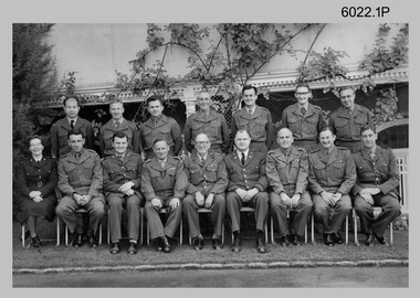
... Front row – L to R: CAPT Carol Castor, MAJ NRJ Hillier, MAJ Bill Howarth, CO LTCOL Frank Buckland OBE MID, DSVY-A COL Don Macdonald MID, GEN Miller – US Director Mapping, MAJ John Nolan, MAJ Eddy Anderson MBE, unknown UK Exchange Officer. .2) - Photo, black & white, c1971. Back row – L to R: LT Jack Gore (Litho Sqn), LT Tom Royle (Adjt), FLT John Sinclair (Canada, Topo Sqn), 2LT Fred Brown (Carto Sqn), Lt John Winzar (Topo Sqn), 2LT Gary Kenney (Litho Sqn), LT Reg Smith (Litho Sqn), 2LT Terry Edwards (Litho Sqn), LT Bob Roche (Carto Sqn). ...Front row – L to R: CAPT Carol Castor, MAJ NRJ Hillier, MAJ Bill Howarth, CO LTCOL Frank Buckland OBE MID, DSVY-A COL Don Macdonald MID, GEN Miller – US Director Mapping, MAJ John Nolan, MAJ Eddy Anderson MBE, unknown UK Exchange Officer. .2) - Photo, black & white, c1971. Back row – L to R: LT Jack Gore (Litho Sqn), LT Tom Royle (Adjt), FLT John Sinclair (Canada, Topo Sqn), 2LT Fred Brown (Carto Sqn), Lt John Winzar (Topo Sqn), 2LT Gary Kenney (Litho Sqn), LT Reg Smith (Litho Sqn), 2LT Terry Edwards (Litho Sqn), LT Bob Roche (Carto Sqn). ...These photographs of Royal Australian Survey Corps commissioned officers was taken at the Army Survey Regiment circa 1962-1965, 1972 and circa 1973-1974. Officer appointments to the Army Svy Regt were typically the CO, 2IC, Adjutant; and an OC, 2IC and Troop Officers assigned to the Headquarters, Topographic/Air Survey, Cartographic and Lithographic Squadrons. RAN and RAAF liaison officers were usually appointed to the Regiment; and occasionally exchange officers from other Corps, the USA or UK.This is a set of photographs of RASvy Officers at the Army Survey Regiment, Bendigo. The photographs were printed on photographic paper and are part of the Army Survey Regiment’s Collection. The photographs were scanned at 300 dpi. .1) - Photo, black & white, 1963. Back row – L to R: unidentified Philippines officer, LT Merv Marks, LT Jorge Gruszka, LT Bill Greer, CAPT Peter Constantine AM, LT Freddy High, MAJ Brian Dalton. Front row – L to R: CAPT Carol Castor, MAJ NRJ Hillier, MAJ Bill Howarth, CO LTCOL Frank Buckland OBE MID, DSVY-A COL Don Macdonald MID, GEN Miller – US Director Mapping, MAJ John Nolan, MAJ Eddy Anderson MBE, unknown UK Exchange Officer. .2) - Photo, black & white, c1971. Back row – L to R: LT Jack Gore (Litho Sqn), LT Tom Royle (Adjt), FLT John Sinclair (Canada, Topo Sqn), 2LT Fred Brown (Carto Sqn), Lt John Winzar (Topo Sqn), 2LT Gary Kenney (Litho Sqn), LT Reg Smith (Litho Sqn), 2LT Terry Edwards (Litho Sqn), LT Bob Roche (Carto Sqn). Front row L to R: CAPT Jack McNeale (RAInf, QM), MAJ John Williams (RE, HQ Sqn), MAJ Keith Todd (OC Carto Sqn), MAJ Don Ridge (Regt 2IC), LTCOL Bill Howarth (CO), MAJ Brian Dalton (OC HQ Sqn), MAJ John Bullen (OC Topo Sqn), Lt Claire Chittleborough (OC WRAAC & Asst Adjt), CAPT Roger Bailey (RE, Topo Sqn). .3) - Photo, black & white c1972. Back row – L to R: 1st 2LT Terry Edwards, 7th LT Gary Kenney, 9th LT Bob Roche. Front row – L to R: 1st CAPT Jack Gore, 3rd CAPT Roger Bailey RE, 4th MAJ Keith Todd, 5th MAJ Don Ridge, 6th LTCOL Bill Howarth, 7th MAJ Brian Dalton, 8th MAJ John Bullen, 9th FLT John Sinclair, 10th CAPT Jack McNeale, , 11th LT Claire Chittleborough. .4) - Photo, black & white, c1972. Personnel named as per .3) .5) - Photo, black & white, c1973-1974. Back row – L to R: 1st LT Graham Baker, 4th MAJ John Sinclair , 7th CAPT Reg Smith, 8th LT Terry Edwards. Front row – L to R: 3rd MAJ Peter Constantine, 4th LTCOL Don Ridge 5th MAJ John Cattell. .6) - Photo, colour print of .5), c1973-1974 Personnel named as per .5).1 no annotation, .2 Personnel (surnames, no rank) annotated on back, .3 to .6 no annotationroyal australian survey corps, rasvy, army survey regiment, army svy regt, fortuna, asr