Showing 17 items matching "jordan gold fields"
-
 Marysville & District Historical Society
Document (item) - Report, Clement Wilks, Track to the River Jordan Gold Fields, 1864-1865
... Track to the River Jordan Gold Fields......jordan gold fields...Track to the River Jordan Gold Fields Document Report Clement Wilks Department of Roads & Bridges John Ferres ...A report by Mr Road Engineer Wilks on the construction of the Yarra Track in Victoria.A report by Mr Road Engineer Wilks on the construction of the Yarra Track in Victoria. The Yarra Track is the former name of the gold fields road from Healesville to the Woods Point and Jordan Goldfields, in Victoria, Australia. By Authority: JOHN FERRES, Government Printer, Melbourneclement wilks, yarra track, marysville, victoria, wood's point, healesville, jordan gold fields -
 Marysville & District Historical Society
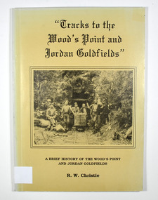
Book, Tracks to the Wood's Point and Jordan Goldfields-A brief history of the Wood's Point and Jordan Goldfields
... gold field...gold mining...gold town...wood's point...jordan...A history of the Wood's Point and Jordan gold fields...Marysville & District Historical Society 39 Darwin Street Marysville yarra-valley-and-the-dandenong-ranges A history of the Wood's Point and Jordan gold fields gold gold field gold mining gold town wood's point jordan goldfields victoria australia history r w christie Stamp of the Marysville & District Historical Society Inc / P.O. ...A history of the Wood's Point and Jordan gold fieldsPaperback. Beige cover. Front cover has a black and white photograph of miners standing and sitting around a mine cart that is sitting on railway tracks at the entrance to a mine.Back cover has a cartoon drawing of a pack horse that has fallen down a cliff with his rider trying to pull him back up by his tail. Inside the cover is a drawn map entitled 'Map of the Mining District round Wood's point'.Stamp of the Marysville & District Historical Society Inc / P.O. Box 22 / Marysville 3779 gold, gold field, gold mining, gold town, wood's point, jordan goldfields, victoria, australia, history, r w christie -
 Marysville & District Historical Society
Book, Tracks to the Wood's Point and Jordan Goldfields-A brief history of the Wood's Point and Jordan Goldfields
... gold field...gold mining...gold town...wood's point...jordan...A history of the Wood's Point and Jordan gold fields...Marysville & District Historical Society 39 Darwin Street Marysville yarra-valley-and-the-dandenong-ranges A history of the Wood's Point and Jordan gold fields gold gold field gold mining gold town wood's point jordan goldfields victoria australia history r w christie Stamp of Marysville & District / Historical Society Inc / P.O. ...A history of the Wood's Point and Jordan gold fieldsPaperback. Beige cover. Front cover has a black and white photograph of miners standing and sitting around a mine cart that is sitting on railway tracks at the entrance to a mine.Back cover has a cartoon drawing of a pack horse that has fallen down a cliff with his rider trying to pull him back up by his tail. Inside the cover is a drawn map entitled 'Map of the Mining District round Wood's point'.Stamp of Marysville & District / Historical Society Inc / P.O. Box 22 / Marysville 3779 gold, gold field, gold mining, gold town, wood's point, jordan goldfields, victoria, australia, history, r w christie -
 Federation University Historical Collection
Letter, Letters written by Richard Squire to his son Tom Squire 1937
... Gold Mines of Australia...Liz the Car...Geoff Squire...Lode...Cameron and Sutherland...Hayes Timber...Alan Squire...Ethel...Ross Creek Field...Ross Creek Gold Mining Co....Frank Herman...Lillas...Jack Hayes...Eyres brothers...G.Gay & Co...Buninyong...Glenfine...The Star Mine of Avoca Fields...Talbot Alluvials...Guildford Plateau...A.B.C. Special Supply Store...Geological Branch...Shell Coy...Lawaluk...Almanac...McBinny...Bingley's Paddock...Cargaire Valley and Lead...Stand and Deliver Demands...Sheehan's...Smeaton Hotel...John Charleson...Aleck Charleson...Ted Brown...Billy Jordan...Gold Mines of Australia Liz the Car Geoff Squire Lode Cameron and Sutherland Hayes Timber Alan Squire Ethel Ross Creek Field Ross Creek Gold Mining Co. Frank Herman Lillas Jack Hayes Eyres brothers G.Gay & Co Buninyong Glenfine The Star Mine of Avoca Fields Talbot Alluvials Guildford Plateau A.B.C. Special Supply Store Geological Branch Shell Coy Lawaluk Almanac McBinny Bingley's Paddock Cargaire Valley and Lead Stand and Deliver Demands Sheehan's Smeaton Hotel John Charleson Aleck Charleson Ted Brown Billy Jordan ...In 1905 Richard Squire was manager of the West Berry Consols at Allendale, and developed an improved system of mine ventilation, which was supported in "The Age."[4] He was successful in combating and remedying the gas and ventilation troubles of the Deep Mines of Creswick and Allendale Districts after all had failed. MINE MANAGERS’ ASSOCIATION. Ballarat Branch. ... Mr R. B. Squire, manager of the West Berry Consols, at Allendale, submitted a paper detailing what he had done tor the betterment of ventilation in the alluvial mines of Smeaton and Mary borough districts- Members gave Mr Squire every credit for the results that he claimed to have effected; the adoption of his ideas had testified to their value to mine-owners. It was painted out, however, that for want of a thorough debate of the subject with experienced men the author had unwittingly included some general statements that required modifying in some points and extending in others, in justice to other workers among the earlier and the present day managers of mines. It was decided to invite the author to meet a sub-committee on this subject!A variety of Letters written by Richard Squire to his son Tom Squire about the goings on at Mt Mercer Mine 1937richard squire, tom squire, hazel squire, jack squire, jim squire, ned, mt mercer, plant, skids, pump, poppet, carburetor, shaft, balance weight, pulleys, syndicate, suction, lease, reports, estimates, flat fields, reef, trucks, pipeclay, sandstone, suction pipe, valves, honeycomb rock, yarrowee, ballarat, reef combs, cheques, yellow slate, leigh river, dyke, quartz, ballarat deep leads, ballarat deep leads extension, bore, reads, bedrock, cemented sand, g m of a, gold mines of australia, liz the car, geoff squire, lode, cameron and sutherland, hayes timber, alan squire, ethel, ross creek field, ross creek gold mining co., frank herman, lillas, jack hayes, eyres brothers, g.gay & co, buninyong, glenfine, the star mine of avoca fields, talbot alluvials, guildford plateau, a.b.c. special supply store, geological branch, shell coy, lawaluk, almanac, mcbinny, bingley's paddock, cargaire valley and lead, stand and deliver demands, sheehan's, smeaton hotel, john charleson, aleck charleson, ted brown, billy jordan, mr banks, ballarat main lead, binney, goon, illabrook, mrs trenery, bre, max, june, mary, len, barry, hunter, herman, martin, aunt annie, bella, pitfield coy, mcnaughtons, donaldson, dereel, hogan, the bay leads, avoca field, ballarat alluvials, neil cameron, haddon field, courier, tom cotton, llewellen, stanley hunter, mr leonard, tom mitchell, school of mines, bryant, a.c. connely, dodson, constable mcmullins, adam ronaldson, bewick mining & co., reginald murray, r.c. selwyn, craig's hotel, broken hill syndicate, morrison's lead, wilkinson, j. hayes, mr nichol, burglary, baragwanath, wilkinson ross, creswick, seville, mr. ross, o'connor, c. mcgrath, alfred mica smith, henderson ross, angus kelly, a. r. dodson, duke of wellington plant, the moorabool lead, williams, paralysis, woodlock, squire, whipp, joe williams, peacock, moran, buchanan, hoare, bree kutchel, kohinoor band and alluvian, star of the east, bonshaw, epidemic, polio, mining -
 Marysville & District Historical Society
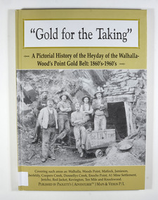
Book - Hardcover book, Gold for the Taking-A Pictorial History of the Heyday of the Walhalla-Wood's Point Gold Belt: 1860's-1960's, 2007
... Marysville & District Historical Society 39 Darwin Street Marysville yarra-valley-and-the-dandenong-ranges A pictorial history of the heyday of the Walhalla-Wood's Point gold belt in the 1860's-1960's gold gold fields gold mining a1 mine settlement aberfeldy beardmore black river group coopers creek donnellys creek enochs point fulton creek gaffneys creek gooleys creek jamieson jordan valley kevington knockwood matlock ten mile walhalla wood's point history victoria Stamp of the Marysville & District Historical Society Inc / P.O. ...A pictorial history of the heyday of the Walhalla-Wood's Point gold belt in the 1860's-1960'sHardcover. The cover is a gold colour. The front cover has a photograph of a group of miners in front of the entry to a mine. On the top entry timber piece is a sign saying "Old Mine". The beginning of the wording is obscured by one of the miners standing in front of the entry. There is also an old mining trolley standing on tracks which lead into the mine.There is also an old gold mining dish sitting on a rock to the left of the entry into the mine.On the back cover is a photograph of Walhalla in modern times as well as a photograph of the publisher of this book. There is also a blurb about the publisher.Stamp of the Marysville & District Historical Society Inc / P.O. Box 22 / Marysville 3779gold, gold fields, gold mining, a1 mine settlement, aberfeldy, beardmore, black river group, coopers creek, donnellys creek, enochs point, fulton creek, gaffneys creek, gooleys creek, jamieson, jordan valley, kevington, knockwood, matlock, ten mile, walhalla, wood's point, history, victoria -
 Marysville & District Historical Society
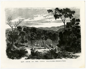
Work on paper (item) - Print of wood engraving, Frederick Grosse et al, New Chum on the Yarra Track, 27-09-1866
... The Yarra Track is the former name of the gold fields road from Healesville to the Woods Point and Jordan Goldfields in Victoria. new chum healesville yarra track victoria frederick grosse albert charles cooke thomas waters wood engraving A copy of an early wood engraving taken from a photograph of the deserted township of New Chum, near Healesville, on the Yarra Track in Victoria. ...A copy of an early wood engraving taken from a photograph of the deserted township of New Chum, near Healesville, on the Yarra Track in Victoria.A copy of an early wood engraving taken from a photograph of the deserted township of New Chum, near Healesville, on the Yarra Track in Victoria. The Yarra Track is the former name of the gold fields road from Healesville to the Woods Point and Jordan Goldfields in Victoria.new chum, healesville, yarra track, victoria, frederick grosse, albert charles cooke, thomas waters, wood engraving -
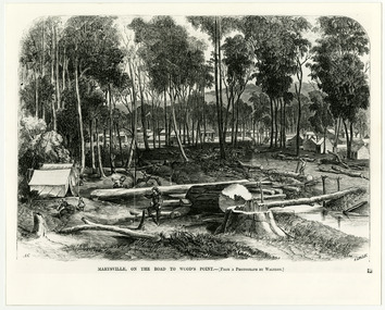 Marysville & District Historical Society
Work on paper (item) - Print of wood engraving, Frederick Grosse et al, Marysville, on the road to Wood's Point, 27-11-1866
... The Yarra Track is the former name of the gold fields road from Healesville to the Woods Point and Jordan Goldfields in Victoria. victoria frederick grosse albert charles cooke thomas waters wood engraving marysville wood's point road A copy of an early wood engraving taken from a photograph of the town of Marysville in Victoria. ...A copy of an early wood engraving taken from a photograph of the township of Marysville in Victoria.A copy of an early wood engraving taken from a photograph of the township of Marysville in Victoria. The Yarra Track is the former name of the gold fields road from Healesville to the Woods Point and Jordan Goldfields in Victoria.victoria, frederick grosse, albert charles cooke, thomas waters, wood engraving, marysville, wood's point road -
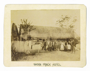 Marysville & District Historical Society
Photograph (Item) - Black and white photograph, Yarra Track Hotel, c1900
... The Yarra Track is the former name of the gold fields road from Healesville to the Woods Point and Jordan Goldfields, in Victoria, Australia. ...An early black and white photograph of a hotel along the Yarra Track.An early black and white photograph of a hotel along the Yarra Track. The Yarra Track is the former name of the gold fields road from Healesville to the Woods Point and Jordan Goldfields, in Victoria, Australia. A direct route via the Yarra River and the Great Divide was discovered by Rieck in September 1862 and became known as the Yarra Track. Early in 1863, the Victorian Government decided to construct a 193-kilometre (120 mile) road along the route. Its original width varied between 4 and 6 metres (12 and 20 feet), and was designed to accommodate horse-drawn vehicles. The Track involved the climbing of the Black Spur, descent into the Acheron Valley, and then through Marysville to the Cumberland where it followed the existing route. Unable to ascertain both the location and name of hotel.ARMSTRONG COLLECTION 42 STATION STREET/ SANDRINGHAM 3191/ TEL. (03) 9521 5442/ IAN M.L. ARMSTRONG OAMyarra track, healesville, wood's point, jordan goldfields, victoria, yarra river, great divide, reick, black spur, acheron valley, marysville, cumberland creek -
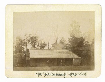 Marysville & District Historical Society
Photograph (Item) - Black and white photograph, The "Scandinavians' - (Deserted), c1900
... The Yarra Track is the former name of the gold fields road from Healesville to the Woods Point and Jordan Goldfields, in Victoria, Australia. ...An early black and white photograph of The Scandinavian's Hotel and Boarding House along the Yarra Track.An early black and white photograph of The Scandinavian's Hotel and Boarding House along the Yarra Track. The Yarra Track is the former name of the gold fields road from Healesville to the Woods Point and Jordan Goldfields, in Victoria, Australia. A direct route via the Yarra River and the Great Divide was discovered by Rieck in September 1862 and became known as the Yarra Track. Early in 1863, the Victorian Government decided to construct a 193-kilometre (120 mile) road along the route. Its original width varied between 4 and 6 metres (12 and 20 feet), and was designed to accommodate horse-drawn vehicles. The Track involved the climbing of the Black Spur, descent into the Acheron Valley, and then through Marysville to the Cumberland where it followed the existing route.ARMSTRONG COLLECTION 42 STATION STREET/ SANDRINGHAM 3191/ TEL. (03) 9521 5442/ IAN M.L. ARMSTRONG OAMthe scandinavians', yarra track, healesville, wood's point, jordan goldfields, victoria, yarra river, great divide, reick, black spur, acheron valley, marysville, cumberland creek -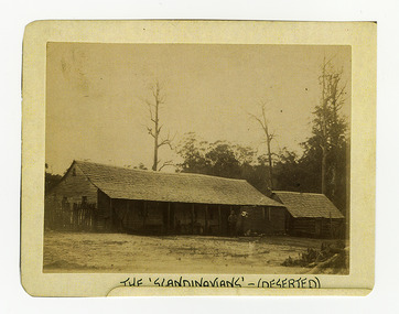
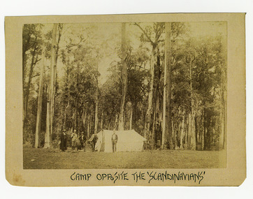 Marysville & District Historical Society
Photograph (Item) - Black and white photograph, Camp Opposite The "Scandinavians', c1900
... The Yarra Track is the former name of the gold fields road from Healesville to the Woods Point and Jordan Goldfields, in Victoria, Australia. ...An early black and white photograph of a camp which was opposite The Scandinavian's Hotel and Boarding House along the Yarra Track.An early black and white photograph of a camp which was opposite The Scandinavian's Hotel and Boarding House along the Yarra Track. The Yarra Track is the former name of the gold fields road from Healesville to the Woods Point and Jordan Goldfields, in Victoria, Australia. A direct route via the Yarra River and the Great Divide was discovered by Rieck in September 1862 and became known as the Yarra Track. Early in 1863, the Victorian Government decided to construct a 193-kilometre (120 mile) road along the route. Its original width varied between 4 and 6 metres (12 and 20 feet), and was designed to accommodate horse-drawn vehicles. The Track involved the climbing of the Black Spur, descent into the Acheron Valley, and then through Marysville to the Cumberland where it followed the existing route.ARMSTRONG COLLECTION 42 STATION STREET/ SANDRINGHAM 3191/ TEL. (03) 9521 5442/ IAN M.L. ARMSTRONG OAMthe scandinavians', yarra track, healesville, wood's point, jordan goldfields, victoria, yarra river, great divide, reick, black spur, acheron valley, marysville, cumberland creek -
Marysville & District Historical Society
Document (Item) - Research Document, Judith Vimpani, William Cavanagh Farrell (1844-1901), 04-2020
... The Yarra Track is the former name of the gold fields road from Healesville to the Woods Point and Jordan Goldfields, in Victoria, Australia. ...An account of the life of William Cavanagh Farrell.An account of the life of William Cavanagh Farrell who was important to Marysville as his review in 1863 of the routes to Wood's Point led to the Yarra Track ascending the Black Spur and going on to what became the resort town of Marysville on the Steavenson River. The Yarra Track is the former name of the gold fields road from Healesville to the Woods Point and Jordan Goldfields, in Victoria, Australia. A direct route via the Yarra River and the Great Divide was discovered by Reick in September 1862 and became known as the Yarra Track. Early in 1863, the Victorian Government decided to construct a 193-kilometre (120 mile) road along the route. Its original width varied between 4 and 6 metres (12 and 20 feet), and was designed to accommodate horse-drawn vehicles. The Track involved the climbing of the Black Spur, descent into the Acheron Valley, and then through Marysville to the Cumberland where it followed the existing route.willaim cavanagh farrell, marysville, victoria, wood's point, yarra track, black spur, steavenson's creek, steavenson river, george theodore rieck -
Marysville & District Historical Society
Document (Item) - Research Document, Judith Vimpani, George Theodore Rieck (1833-pos 1884), 04-2020
... The Yarra Track is the former name of the gold fields road from Healesville to the Woods Point and Jordan Goldfields, in Victoria, Australia. ...An account of the life of George Theodore Rieck.An account of the life of George Theodore Rieck. The Yarra Track is the former name of the gold fields road from Healesville to the Woods Point and Jordan Goldfields, in Victoria, Australia. A direct route via the Yarra River and the Great Divide was discovered by Rieck in September 1862 and became known as the Yarra Track. Early in 1863, the Victorian Government decided to construct a 193 kilometre (120 mile) road along the route. Its original width varied between 4 and 6 metres (12 and 20 feet), and was designed to accommodate horse-drawn vehicles. The Track involved the climbing of the Black Spur, descent into the Acheron Valley, and then through Marysville to the Cumberland where it followed the existing route.george theordore rieck, marysville, victoria, james murphy, new chum creek, wood's point, gold mining, matlock, walhalla, yarra track -
Marysville & District Historical Society
Booklet (Item) - Information booklet, Artworkz Tourism, The Big Culvert, Unknown
... The Yarra Track is the former name of the gold fields road from Healesville to the Woods Point and Jordan Goldfields, in Victoria, Australia. ...An information booklet that was produced as a guide to The Big Culvert.An information booklet that was produced as a guide to The Big Culvert. The Big Culvert is a historic granite and bluestone arch along the Yarra Track, a major route to Melbourne through the 1800s. Built in 1870 and a major piece of infrastructure for its time, the heritage listed culvert allowed water to flow under often-flooded the road. The Yarra Track is the former name of the gold fields road from Healesville to the Woods Point and Jordan Goldfields, in Victoria, Australia. A direct route via the Yarra River and the Great Divide was discovered by Rieck in September 1862 and became known as the Yarra Track. Early in 1863, the Victorian Government decided to construct a 193-kilometre (120 mile) road along the route. Its original width varied between 4 and 6 metres (12 and 20 feet), and was designed to accommodate horse-drawn vehicles. The Track involved the climbing of the Black Spur, descent into the Acheron Valley, and then through Marysville to the Cumberland where it followed the existing route.the big culvert, yarra track, victoria, healesville, wood's point goldfields, jordan goldfields, black spur, acheron valley, cumberland valley -
Marysville & District Historical Society
Flyer (Item) - Information flyer, Artworkz Tourism, The Big Culvert, 26-03-2016
... The Yarra Track is the former name of the gold fields road from Healesville to the Woods Point and Jordan Goldfields, in Victoria, Australia. ...An information flyer that was produced as a guide to The Big Culvert.An information flyer that was produced as a guide to The Big Culvert. The Big Culvert is a historic granite and bluestone arch along the Yarra Track, a major route to Melbourne through the 1800s. Built in 1870 and a major piece of infrastructure for its time, the heritage listed culvert allowed water to flow under often-flooded the road. The Yarra Track is the former name of the gold fields road from Healesville to the Woods Point and Jordan Goldfields, in Victoria, Australia. A direct route via the Yarra River and the Great Divide was discovered by Rieck in September 1862 and became known as the Yarra Track. Early in 1863, the Victorian Government decided to construct a 193-kilometre (120 mile) road along the route. Its original width varied between 4 and 6 metres (12 and 20 feet), and was designed to accommodate horse-drawn vehicles. The Track involved the climbing of the Black Spur, descent into the Acheron Valley, and then through Marysville to the Cumberland where it followed the existing route.the big culvert, yarra track, victoria, healesville, wood's point goldfields, jordan goldfields, black spur, acheron valley, cumberland valley -
 Marysville & District Historical Society
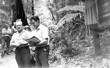
Photograph (Item) - Black and white photograph, Unknown
... The Yarra Track is the former name of the gold fields road from Healesville to the Woods Point and Jordan Goldfields, in Victoria, Australia. ...A black and white photograph taken at the unveiling of the sign placed at The Big Culvert.A black and white photograph taken at the unveiling of the sign placed at The Big Culvert. The Big Culvert is a historic granite and bluestone arch along the Yarra Track, a major route to Melbourne through the 1800s. Built in 1870 and a major piece of infrastructure for its time, the heritage listed culvert allowed water to flow under often-flooded the road. The Yarra Track is the former name of the gold fields road from Healesville to the Woods Point and Jordan Goldfields, in Victoria, Australia. A direct route via the Yarra River and the Great Divide was discovered by Rieck in September 1862 and became known as the Yarra Track. Early in 1863, the Victorian Government decided to construct a 193-kilometre (120 mile) road along the route. Its original width varied between 4 and 6 metres (12 and 20 feet), and was designed to accommodate horse-drawn vehicles. The Track involved the climbing of the Black Spur, descent into the Acheron Valley, and then through Marysville to the Cumberland where it followed the existing route.Unveiling of sign/ at "Big Culvert" In front Max Cockerrell and - Rear: second back Geoff Pope R.H.S. rear: Nancy "/ Anne "the big culvert, yarra track, victoria, healesville, wood's point goldfields, jordan goldfields, black spur, acheron valley, cumberland valley -
 Marysville & District Historical Society
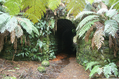
Photograph (Item) - Colour photograph, 20-09-2008
... The Yarra Track is the former name of the gold fields road from Healesville to the Woods Point and Jordan Goldfields, in Victoria, Australia. ...A colour photograph of the entrance to The Big Culvert.A colour photograph of the entrance to The Big Culvert. The Big Culvert is a historic granite and bluestone arch along the Yarra Track, a major route to Melbourne through the 1800s. Built in 1870 and a major piece of infrastructure for its time, the heritage listed culvert allowed water to flow under often-flooded the road. The Yarra Track is the former name of the gold fields road from Healesville to the Woods Point and Jordan Goldfields, in Victoria, Australia. A direct route via the Yarra River and the Great Divide was discovered by Rieck in September 1862 and became known as the Yarra Track. Early in 1863, the Victorian Government decided to construct a 193-kilometre (120 mile) road along the route. Its original width varied between 4 and 6 metres (12 and 20 feet), and was designed to accommodate horse-drawn vehicles. The Track involved the climbing of the Black Spur, descent into the Acheron Valley, and then through Marysville to the Cumberland where it followed the existing route.the big culvert, yarra track, victoria, healesville, wood's point goldfields, jordan goldfields, black spur, acheron valley, cumberland valley