
Showing 5 items matching "kangaroo flat floods"
-
 Bendigo Historical Society Inc.
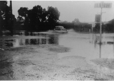
Photograph - Black and white photos high Street Kangaroo Flat
... kangaroo Flat floods...3 photographs floods kangaroo flat a) Car driving through flood waters dated 1949 b) Car driving through flood waters/Sympags behind cyoress hedge dated 1949 c) Car driving through flodd waters Stevenson's "Balmoral" and Morrison's Homes dated 1935 Original photos owned by G. ...Kangaroo Flat" in 1993. Edith was a lifelong member of St. Mary's Anglican Church and the archive room is named in her honour. kangaroo Flat floods cars 3 photographs floods kangaroo flat a) Car driving through flood waters dated 1949 b) Car driving through flood waters/Sympags behind cyoress hedge dated 1949 c) Car driving through flodd waters Stevenson's "Balmoral" and Morrison's Homes dated 1935 Original photos owned by G. ...Edith Isabel Johanson was born in Kangaroo Flat in 1929. She lived there for most of her life until her death in 2019. Her parents Percy and Violet Johanson lived in Station Street and operated Kangaroo Flat Buslines. Edith had one brother - Warwick. Edith married Arthur Henry Perry in 1952. They had three children - Lynton, Malcolm and Leonie. Edith completed her initial teacher training at Melbourne Teachers' College and later studied part time to become a Teacher Librarian. She then worked at the Bendigo Teachers' College until her retirement. Edith was an active member of her Community. She was involved in building a new kindergarten and Infant Welfare Centre in the 1960s, and actively involved in the activities of the Shire of Marong. Edith was a member of the Committee that produced David Horsfall's "History of Kangaroo Flat" in 1993. Edith was a lifelong member of St. Mary's Anglican Church and the archive room is named in her honour.3 photographs floods kangaroo flat a) Car driving through flood waters dated 1949 b) Car driving through flood waters/Sympags behind cyoress hedge dated 1949 c) Car driving through flodd waters Stevenson's "Balmoral" and Morrison's Homes dated 1935 Original photos owned by G. Rusbridge kangaroo flat floods, cars -
 Eltham District Historical Society Inc
Album - Photograph Album, J.A. McDonald, Bridge and Road Reconstruction Works, Shire of Eltham, 1952-1962
... Flat Rock Road...Flood damage...floods...Floodwater...Footpaths and gutters...Ford Service Garage...G. Blair...Garden Hill...Glen Park Bridge...Glenauburn Road...Grand Hotel...Haldane Road...Healesville...Healesville-Yarra Glen Road...Heidelberg-Kinglake Road...Henley Road Bridge...Henley Road...Hill property...Hurstbridge Water scheme...Hurstbridge...Hurstbridge-Arthurs Creek Road...Infrastructure...J. Jolly...Kangaroo...Flat Rock Road Flood damage floods Floodwater Footpaths and gutters Ford Service Garage G. Blair Garden Hill Glen Park Bridge Glenauburn Road Grand Hotel Haldane Road Healesville Healesville-Yarra Glen Road Heidelberg-Kinglake Road Henley Road Bridge Henley Road Hill property Hurstbridge Water scheme Hurstbridge Hurstbridge-Arthurs Creek Road Infrastructure J. Jolly Kangaroo ...J.A. McDonald produced this record in the course of his responsibilities as Shire Engineer for Eltham Shire Council.Record of various Shire of Eltham infrastructure works undertaken during the period of 1952-1962 involving bridge and road reconstruction projects, sometimes with Eltham Shire Council Project Reference numbers quoted. It was during this period that a number of significant improvements were made to roads and new bridges constructed within the shire that remain in place as of present day (2022). In many situations, the photos provide a tangible visible record of infrastructure that existed throughout the early days of the Shire. The album was put together by or under the direction of the Shire Engineer, J.A. McDonald.a. gillies, alistair knox park, benchmark studies, bend of islands, blease road, box hill state school, box hill teachers college, box hill tip, bridge construction, bridge street bridge, bridge, brisbane street, brougham steet, bulldozer, cecil street, charis pelling, cherry tree road, city of preston, cr. a. brinkkotter, cr. charis pelling, cranes, cromwell street, diamond creek (creek), diamond street, dixons creek bridge, dixon's creek road, drott, eltham leisure centre, eltham north, eltham police station, eltham, eltham-yarra glen road, f. wood, fitzsimons lane bridge, flat rock road, flood damage, floods, floodwater, footpaths and gutters, ford service garage, g. blair, garden hill, glen park bridge, glenauburn road, grand hotel, haldane road, healesville, healesville-yarra glen road, heidelberg-kinglake road, henley road bridge, henley road, hill property, hurstbridge water scheme, hurstbridge, hurstbridge-arthurs creek road, infrastructure, j. jolly, kangaroo ground, kangaroo ground-queenstown road, kangaroo ground-st andrews road, lilydale shire office, long gully bridge, long gully creek, long gully road, long gully, lower plenty bridge, lower plenty footbridge, lower plenty oval, lower plenty road, lower plenty, main road, methodist church, montmorency, mount pleasant road, new holland, old healesville road, opening ceremony, oxley bridge, para road, paul creek bridge, paul creek road, paul krafeznk, pinnacle lane, plaques, plenty river trail, plenty river, presbyterian church, prof donald thomson, pryor street, railway crossing, railway parade, rattray road, reconstruction works, reichelt avenue, research (vic.), research oval, road construction, rymers corner, shire of eltham, shire of whittlesea, silvan road bridge, silver street bridge, silver street, sir dallas brooks, smedley property, st andrews, steels creek, susan street, tarrawarra, tony carberry, uniting church, upper yarra dam, upper yarra reservoir, w.e. wolf, waterfall property, watsons creek, wattletree road bridge, wattletree road, wattletree road bridge, worlingworth, yarra glen, york street, yow yow creek -
 Bendigo Historical Society Inc.
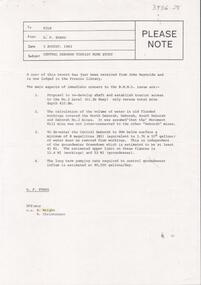
Letter - KANGAROO FLAT GOLD MINE COLLECTION: FILE RECORD RE CENTRAL DEBORAH TOURIST MINE STUDY, 3rd August 1983
... flooded workings in North Deborah, Deborah, South Deborah and Deborah No. 2 mines 3. Volume of water involved in dewatering Central Deborah to 90m below the surface 4. Long term pumping reate required to control groundwater influx, estimated to be 90,500 gallons/day. Letter KANGAROO FLAT ...File memo, from D.F. Evans, 3 August, 1983 re Central Deborah Tourist Mine Study, discussing the report from John Reynolds now lodged in the Preston Library. Main aspects of concern in report to Bendigo Mining NL are: 1. Proposal to redevelop shaft and establish tourist access 2. Calculation of volume of water in old flooded workings in North Deborah, Deborah, South Deborah and Deborah No. 2 mines 3. Volume of water involved in dewatering Central Deborah to 90m below the surface 4. Long term pumping reate required to control groundwater influx, estimated to be 90,500 gallons/day.bendigo, gold mining, central deborah gold mine, central deborah gold mine, dewatering, ground water, mining, bendigo mining nl -
 Bendigo Military Museum
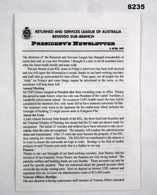
Newsletter - PRESIDENTS NEWSLETTER BRSL 1997, Bendigo RSL Sub Branch, April 1997
... Main points are; Mr Cliff Closehy stepping down after a Presidency of a rewarding 3 years and his foresight in building the 22 single living Units in Kangaroo Flat, Veterans Affairs having permanent Office in Bendigo, new direction in having trained Pension Officers, long standing Welfare Officer Les Waters stands down, role taken on by Jack Martin, New Appeals director Malcolm Angus taking over from long term men, Ted Kenedy & Ern Jackman, , new plaque to be unveiled at the Tom Flood Sports Centre (old Bendigo Show Grounds) commemorating the place as a WW2 Training Camp, Our Ladies Auxiliary now only catering for Ex Service organizations, The Volunteers who have helped transform the the Billiard room into a Memorabilia room especially C Richards for acquiring a Grant from Veterans Affairs to set the room up, the new Regional Centres being set up for Pensions & Welfare....Main points are; Mr Cliff Closehy stepping down after a Presidency of a rewarding 3 years and his foresight in building the 22 single living Units in Kangaroo Flat, Veterans Affairs having permanent Office in Bendigo, new direction in having trained Pension Officers, long standing Welfare Officer Les Waters stands down, role taken on by Jack Martin, New Appeals director Malcolm Angus taking over from long term men, Ted Kenedy & Ern Jackman, , new plaque to be unveiled at the Tom Flood Sports Centre (old Bendigo Show Grounds) commemorating the place as a WW2 Training Camp, Our Ladies Auxiliary now only catering for Ex Service organizations, The Volunteers who have helped transform the the Billiard room into a Memorabilia room especially C Richards for acquiring a Grant from Veterans Affairs to set the room up, the new Regional Centres being set up for Pensions & Welfare. brsl smirsl newsletter 1997 Newsletter, paper A4 folded in half to make 4 pages, print in all black, there are 15 sub headings throughout. ...This Newsletter was the first by the newly elected Bendigo RSL Sub Branch President Alan Holmes at the AGM early 1997. The 15 sub headings are, Annual meeting, About the Units, Finance, Veterans Affairs, pension, Welfare, Appeals, Commemorative plaque, RSL Corporate plan, Ladies Auxiliary, memorabilia room, In general, Mufti and General meetings. Main points are; Mr Cliff Closehy stepping down after a Presidency of a rewarding 3 years and his foresight in building the 22 single living Units in Kangaroo Flat, Veterans Affairs having permanent Office in Bendigo, new direction in having trained Pension Officers, long standing Welfare Officer Les Waters stands down, role taken on by Jack Martin, New Appeals director Malcolm Angus taking over from long term men, Ted Kenedy & Ern Jackman, , new plaque to be unveiled at the Tom Flood Sports Centre (old Bendigo Show Grounds) commemorating the place as a WW2 Training Camp, Our Ladies Auxiliary now only catering for Ex Service organizations, The Volunteers who have helped transform the the Billiard room into a Memorabilia room especially C Richards for acquiring a Grant from Veterans Affairs to set the room up, the new Regional Centres being set up for Pensions & Welfare.Newsletter, paper A4 folded in half to make 4 pages, print in all black, there are 15 sub headings throughout. First page at the top has the RSL Logo on the left then the Sub branch being Bendigo central, under is "Presidents Newsletter" with the date "3 April 1997"brsl, smirsl, newsletter, 1997 -
 Ballarat Heritage Services
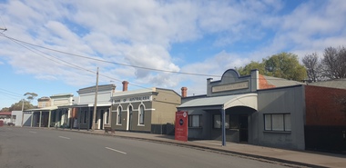
Photograph, Main Street of Talbot, Victoria, 2025, 07/2025
... Kangaroo Flat along Back Creek (1km out of Talbot). By November 1855 it was reported around 6,000 miners had taken up residence in what became known as Back Creek. But, as the gold dwindled, so too did the population and by end-1857 only a few houses remained. In 1859, a group of miners from Norway and Sweden led by Carl Hallen decided to look in an area just outside of Back Creek, previously thought barren of gold as it was un-forested. Their gamble was rewarded, and as the news spread, miners once again flooded...Kangaroo Flat along Back Creek (1km out of Talbot). By November 1855 it was reported around 6,000 miners had taken up residence in what became known as Back Creek. But, as the gold dwindled, so too did the population and by end-1857 only a few houses remained. In 1859, a group of miners from Norway and Sweden led by Carl Hallen decided to look in an area just outside of Back Creek, previously thought barren of gold as it was un-forested. Their gamble was rewarded, and as the news spread, miners once again flooded ...Throughout the 1840s there had been rumours of gold found in the area, but the evidence was suppressed. The authorities sought to keep the region as a quiet pastoral district, and feared that a gold rush could spark chaos and lawlessness among the largely convict population. In January 1849, former convict Thomas Chapman found a 38 ounce gold nugget in Daisy Hill Creek (7 km from Talbot) while working as a shepherd. He sold it to Melbourne jeweller Charles Brentani in early 1849. This was the first confirmed finding of gold in Victoria and kicked off a minor rush to the region. By late February 1849 thirty to forty trespassers were reported to have gathered at Thomas's former hut seeking gold before being disbanded by a party of police sent from Melbourne. Meanwhile, Thomas fled to Sydney, fearing trouble after his unauthorised sale of the gold that, according to the law of the time, was illegal. The first major rush in the area around current day Talbot occurred in December 1852 when gold was found in Daisy Hill, near what is now Amherst Cemetery (2km west of Talbot). News quickly spread and within a few weeks hundreds of miners from the nearby Castlemaine goldfields had arrived to try their luck. The next major gold find was in 1854 at Kangaroo Flat along Back Creek (1km out of Talbot). By November 1855 it was reported around 6,000 miners had taken up residence in what became known as Back Creek. But, as the gold dwindled, so too did the population and by end-1857 only a few houses remained. In 1859, a group of miners from Norway and Sweden led by Carl Hallen decided to look in an area just outside of Back Creek, previously thought barren of gold as it was un-forested. Their gamble was rewarded, and as the news spread, miners once again flooded into the area. Within 4 months of the Hallan Party's first shaft being dug, there were 50,000 people in the Back Creek region. To cater for this influx, streets were improvised in the area of the diggings - starting with what became known as "Scandinavian Crescent" along the edge of the actual diggings themselves. It remains to this day and is now the main street of Talbot. (https://www.melbourneplaygrounds.com.au/talbot-heritage-walk accessed 19 July 2025)Colour photograph of shops on Scandinavian Cresent, the Main road of Talbot, Victoriatalbot, back creek, gold mining
