Showing 43 items matching "lake tyers - east gippsland."
-
 Orbost & District Historical Society
black and white photograph, late 19th century - early 20th century
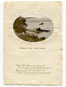
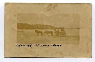
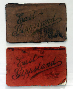
... Lake-Tyers-East-Gippsland greeting-card...Lake Tyers, East Gippsland, Victoria, Australia...This one record an earlier means of transport in east Gippsland. Lake-Tyers-East-Gippsland greeting-card on front just below photograph - CROSSING LAKE TYERS SANDS Beneath that in cursive script is " This little view is sent from here To wish you joy and Christmas cheer And say you are remembered still with kindly thoughts and right goodwill" A small black / white oval shaped photograph set in a cream card with green writing at the bottom. ...This photograph has been set as Christmas postcard. It could be the front page of a greeting card.Postcards and greeting form a vital part of social and historical records for researchers. They are very interesting records of places gone, architecture gone and people gone, showing social history such as dress, or early automobiles. This one record an earlier means of transport in east Gippsland.A small black / white oval shaped photograph set in a cream card with green writing at the bottom. The photo is of two horse teams and buggies crossing a large sandy beach.on front just below photograph - CROSSING LAKE TYERS SANDS Beneath that in cursive script is " This little view is sent from here To wish you joy and Christmas cheer And say you are remembered still with kindly thoughts and right goodwill"lake-tyers-east-gippsland greeting-card -
 Orbost & District Historical Society
black and white photograph, 1.3.1921
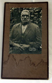
... Lake Tyers, East Gippsland, Victoria, Australia ...In 1861 the Lake Tyers Mission Station was established by the Church of England missionary Reverend John Bulmer, to house some of the Gunaikurnai survivors of the conflict. The peninsula, which has a lake on each side, was known to its traditional owners as Bung Yarnda.A black/white photograph of an older bearded Aboriginal man in a suit sitting in front a leafy bush. The photograph is glued onto cardboard with a black frame."Black Andy of Lake Tyers ORBOST 1/3/21" L.G.W. photo 741lake-tyers aboriginal-mission -
 Orbost & District Historical Society
black and white photograph, "Black Andy of lake Tyers ORBOST 1/3/21", 1. 2.1921
... Lake Tyers, East Gippsland, Victoria, Australia ...In 1861 the Lake Tyers Mission Station was established by the Church of England missionary Reverend John Bulmer, to house some of the Gunaikurnai survivors of the conflict. The peninsula, which has a lake on each side, was known to its traditional owners as Bung Yarnda.A black and white photograph of an older, bearded Aboriginal man. He is sitting outdoors in front of a leafy bush. He is wearing a suit.Black Andy of Lake Tyers ORBOST 1/3/21 L.G.W. photo 741lake-tyers photograph -
 Orbost & District Historical Society
oil painting, 1889
... Lake Tyers, East Gippsland, Victoria, 3888, Australia ...Unframed oil painting on thick cardboard. Painting is of three men in a rowing boat on a river in background and close up of one man in boat.painting lake-tyers illustrations-oil -
 Orbost & District Historical Society
black and white photograph, late 19th century - early 20th century
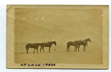
... Lake Tyers, East Gippsland, Victoria, Australia...Lake Tyers. This is associated with early transport in East Gippsland. lake-tyers coulson-coach-driver transport-horse-drawn on front - At Lake Tyers on back - "Mr A. ...In the late 19th century in the Orbost area roads were just bush tracks which generally were unsuitable for any type of vehicular traffic so were traversed mainly by horseback. As the settlement grew, a weekly mail service from Cunninghame (Lakes Entrance) was estab-lished. The settlers had to carry the mail for three months and each took a turn as mailman during that time. The first coach was driven by Mr Alex Hall. Eventually a daily mail service was set up and many drivers included B. Sutherland, W. Middleton, Jonson Bros., J. Mitchell, F. Newport, J. Geddes, A. Coulson, Bert Cessor, H. Weekes and A. Barthile. (info. from Newletter August 2007) This photograph is one of A. Coulson’s Coach crossing the Sand Bar at Lake Tyers.This is associated with early transport in East Gippsland.A black / white postcard photograph of four horses alone on a beach.on front - At Lake Tyers on back - "Mr A. Coulson, coach driver, Orbost"lake-tyers coulson-coach-driver transport-horse-drawn -
 Orbost & District Historical Society
black and white photograph, October 1910
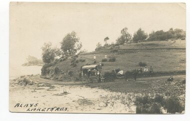
... Lake Tyers, East Gippsland, Victoria, Australia ...There is no information with this item. The Blays had a property on the opposite side of Lake Tyers C 1910 - 1950'This is a pictorial record of Lake Tyers in the early 20th century.A black / white photograph / postcard of a horse and coach with two young girls standing on a hill behind the coach, two men are sitting on the hill in front of the coach and two men beside it.on front - "Blays - Lake Tyers" on back is a letter beginning "Dear Albert......"lake-tyers blay-lake-tyers -
 Orbost & District Historical Society
black and white photograph, late 19th - early 20th century
... Lake Tyers, East Gippsland, Victoria, Australia...Lake Tyers. This is a pictorial record of very early transport in East Gippsland. lake-tyers transport coulson-coaches on front in black writing - " Crossing at Lake Tyers" on back - "A Coulson" A very faded small postcard / photograph of a horse and cart crossing a beach. black and white photograph ...In the late 19th century in the Orbost area roads were just bush tracks which generally were unsuitable for any type of vehicular traffic so were traversed mainly by horseback. As the settlement grew, a weekly mail service from Cunninghame (Lakes Entrance) was estab-lished. The settlers had to carry the mail for three months and each took a turn as mailman during that time. The first coach was driven by Mr Alex Hall. Eventually a daily mail service was set up and many drivers included B. Sutherland, W. Middleton, Jonson Bros., J. Mitchell, F. Newport, J. Geddes, A. Coulson, Bert Cessor, H. Weekes and A. Barthile. (info. from Newletter August 2007) This photograph is one of A. Coulson’s Coach crossing the Sand Bar at Lake Tyers.This is a pictorial record of very early transport in East Gippsland.A very faded small postcard / photograph of a horse and cart crossing a beach.on front in black writing - " Crossing at Lake Tyers" on back - "A Coulson"lake-tyers transport coulson-coaches -
Koorie Heritage Trust
Pamphlet, Aboriginal History Programme, Lake Tyers
... ...Lake Tyers - East Gippsland..... -- 19th century - general. Lake Tyers - East Gippsland. Gives the timeline of history for Lake Tyers reserve and mission together with families. ...Gives the timeline of history for Lake Tyers reserve and mission together with families. Brief history and list of family surnames of residents at Lake Tyers 1878 - 1924.1 pamphlet 6 P.; ports.; maps; 21 cm.Gives the timeline of history for Lake Tyers reserve and mission together with families. Brief history and list of family surnames of residents at Lake Tyers 1878 - 1924.communities, settlements, reserves, missions, etc. -- 19th century - general., lake tyers - east gippsland. -
Lakes Entrance Historical Society
Book, Brooks, Sharon, The Glasshouse Site, Lake Tyers, 1999
... Research, interpretation and management recommendations for the Glasshouse Site, Lake Tyers, East Gippsland, Victoria by Forestech Student....Lakes Entrance Historical Society 4 Marine Parade Lakes Entrance gippsland Industrial Waterways Research, interpretation and management recommendations for the Glasshouse Site, Lake Tyers, East Gippsland, Victoria by Forestech Student. ...Research, interpretation and management recommendations for the Glasshouse Site, Lake Tyers, East Gippsland, Victoria by Forestech Student.industrial, waterways -
Lakes Entrance Historical Society
Book - Methodist Church Camp Park at Lake Tyers Beach, Henderson, Jim, Crossing the Bar, 1992
... A computer printout of the draft for the author's book, telling the Methodist Church Camp Park at Lake Tyers Beach East Gippsland...History Settlement A computer printout of the draft for the author's book, telling the Methodist Church Camp Park at Lake Tyers Beach East Gippsland Crossing the Bar Book Methodist Church Camp Park at Lake Tyers Beach Henderson, Jim ...A computer printout of the draft for the author's book, telling the Methodist Church Camp Park at Lake Tyers Beach East Gippslandhistory, settlement -
 Lakes Entrance Historical Society
Photograph - Beachfield Farm Country Restaurant, Lakes Post Newspaper, 1990
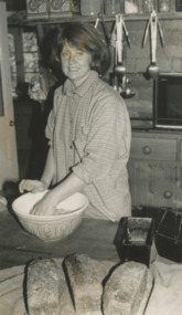
... Black and white photograph showing Caroline Joiner preparing dough for bread baked every day at Beachfield Farm Country Restaurant Lake Tyers Beach Road Toorloo East Gippsland Victoria...Lakes Entrance Historical Society 4 Marine Parade Lakes Entrance gippsland Businesses Black and white photograph showing Caroline Joiner preparing dough for bread baked every day at Beachfield Farm Country Restaurant Lake Tyers Beach Road Toorloo East Gippsland Victoria Photograph Beachfield Farm Country Restaurant Lakes Post Newspaper ...Black and white photograph showing Caroline Joiner preparing dough for bread baked every day at Beachfield Farm Country Restaurant Lake Tyers Beach Road Toorloo East Gippsland Victoriabusinesses -
 Orbost & District Historical Society
pictorial magazine, East Gippsland Floods A Retrospective, 2007
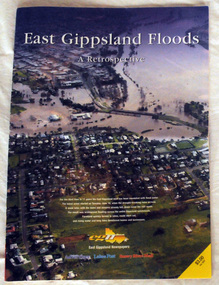
... A magazine pictorial with photos of the June/July East Gippsland flood event in 2007. Photos are of Bairnsdale, Lakes Entrance, Lake Tyers, Orbost, Linenow, Metung, Eagle Point and Paynesville....East Gippsland News as a record of the Floods of June/July 2007. This is a contemporary record of a local event. floods-east gippsland disasters-flood A magazine pictorial with photos of the June/July East Gippsland flood event in 2007. Photos are of Bairnsdale, Lakes Entrance, Lake Tyers ...This magazine pictorial was produced by East Gippsland News as a record of the Floods of June/July 2007.This is a contemporary record of a local event.A magazine pictorial with photos of the June/July East Gippsland flood event in 2007. Photos are of Bairnsdale, Lakes Entrance, Lake Tyers, Orbost, Linenow, Metung, Eagle Point and Paynesville.floods-east gippsland disasters-flood -
 Orbost & District Historical Society
black and white photograph / postcard, Early 20th century - pre 1906?
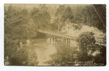
... This is a pictorial record of a bridge in East Gippsland in the early 20th century. bridge-hospital-creek tostaree-bridge in front at bottom - "Hospital Creek in flood H.D.Bulmer photo Lake Tyers" A black / white photograph / postcard of a road bridge across a flooded creek. ...This photograph shows the Hospital Creek in flood. This is a pictorial record of a bridge in East Gippsland in the early 20th century.A black / white photograph / postcard of a road bridge across a flooded creek. It is in a bush setting.in front at bottom - "Hospital Creek in flood H.D.Bulmer photo Lake Tyers"bridge-hospital-creek tostaree-bridge -
 Orbost & District Historical Society
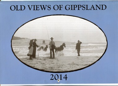
calendar, Old Views of Gippsland 2014, 2013
... Gippsland". On the blue coloured front is a black/white photograph of carriage horses being crossed through a lake entrance presumed to be Lake Tyers around the turn of the century C 1900 . It contains early photographs of East...East Gippsland Historical Society. This item is a useful reference tool. A 2014 stapled calendar, titled "Old Views of Gippsland". On the blue coloured front is a black/white photograph of carriage horses being crossed through a lake entrance presumed to be Lake Tyers around the turn of the century C 1900 . ...This is one of a series of calendars published annually by East Gippsland Historical Society.This item is a useful reference tool.A 2014 stapled calendar, titled "Old Views of Gippsland". On the blue coloured front is a black/white photograph of carriage horses being crossed through a lake entrance presumed to be Lake Tyers around the turn of the century C 1900 . It contains early photographs of East Gippsland, one for each month. There is a hole for hanging. The title is at the top and the year at the bottom in black print. -
 Orbost & District Historical Society
Book, The Cunninghame Progressive Association, Guide to Buchan Caves & the Gippsland Lakes, c.1900-1910
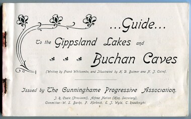
... Gippsland Lakes and Buchan Caves. It was most likely printed in the early 20th Century. This promotion also includes associated areas such as Lake Tyers, Cunninghame (Lakes Entrance), Nowa Nowa, Sale, and Bairnsdale. An early tourist promotion for East...Gippsland Lakes and Buchan Caves. It was most likely printed in the early 20th Century. This promotion also includes associated areas such as Lake Tyers, Cunninghame (Lakes Entrance), Nowa Nowa, Sale, and Bairnsdale. An early tourist promotion for East ...This booklet was issued as a tourist advertising/promotion for the Gippsland Lakes and Buchan Caves. It was most likely printed in the early 20th Century. This promotion also includes associated areas such as Lake Tyers, Cunninghame (Lakes Entrance), Nowa Nowa, Sale, and Bairnsdale. An early tourist promotion for East Gippsland, focussing on Melbourne tourists travelling to Sale or Bairnsdale by train, and then by steamer or coach. An example of an early tourism promotion.A booklet of 103 pages, printed in b/w. The cover is a dk. red paper with gold print, quite fragile. The book contains b/w photographs, advertisements, time tables for trains and steamers travelling through the Gippsland Lakes from Sale to Cunninghame (eg. SS JCD), also a map of the steamer route. ...Guide... To the Gippsland Lakes and Buchan Caves (Written by Frank Whitcombe, and Illustrated by H D Bulmer and N J Caire). Issued by The Cunninghame Progressive Association. J R Coate (President), Alfred Nation (Hon. Secretary), Committee - W S Barke, P Harbeck, E J Wyld, T Roadknightbuchan caves, gippsland lakes, ss j c d, tourism -
 Orbost & District Historical Society
black and white photograph, c1920-1954
... gippsland This is a copy of "THE BRIDGE AT BOGGY CREEK, NOWA NOWA, LAKE TYERS." which is a Rose Stereograph Co postcard. Boggy Creek Bridge was built in 1916 as part of the Bairnsdale to Orbost extension to the main Gippsland Railway, and is situated in the middle of the township of Nowa Nowa, crossing a steep-sided and well-timbered creek-valley. This section of the line closed in 1987. This bridge plays a major part in the identity and history of the town of Nowa Nowa, This item is associated with the East ...This is a copy of "THE BRIDGE AT BOGGY CREEK, NOWA NOWA, LAKE TYERS." which is a Rose Stereograph Co postcard. Boggy Creek Bridge was built in 1916 as part of the Bairnsdale to Orbost extension to the main Gippsland Railway, and is situated in the middle of the township of Nowa Nowa, crossing a steep-sided and well-timbered creek-valley. This section of the line closed in 1987. This bridge plays a major part in the identity and history of the town of Nowa Nowa, This item is associated with the East Gippsland Railway.A large black / white photograph of a large wooden bridge across a creek. There is a house and outbuildings in the background on the right. It is in a bush setting. on back - "Boggy Creek bridge - Nowa Nowa 1887 LaTrobe Collection"boggy-creek-bridge east-gippsland-railway -
 Orbost & District Historical Society
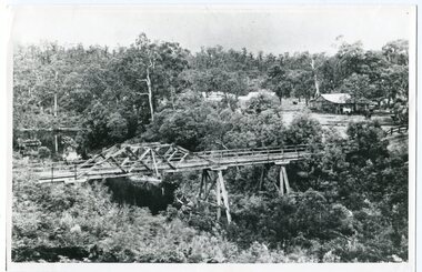
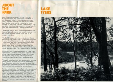
pamphlet, Lake Tyers Forest Park, 1960's
... East Gippsland. This item is a useful reference tool. pamphlet lake tyers-forest-park A three fold glossy, pamphlet titled"Lake Tyers Forest Park". ...This pamphlet would have been produced as a tourist guide to East Gippsland.This item is a useful reference tool.A three fold glossy, pamphlet titled"Lake Tyers Forest Park". It contains information, a map and black / white photographs of Lake Tyers Park. Print colours are brown, white, yellow and black.pamphlet lake tyers-forest-park -
 Orbost & District Historical Society
magazines, Atlas Press Pty Ltd, East Gippsland & Railway Extension, 10 September 1908
... East Gippsland Railway League had proposed a railway extension through East Gippsland in 1908, which aimed to develop an isolated part of the country. At the time, construction of a railway could be considered a beneficial investment for the country as it could increase the population in the region. The proposed railway length in 1908 was about 140 miles and the cost was estimated £800,000. The line was proposed to proceed from Bairnsdale by way of the Lower Nicholson to Bruthen. “After crossing the Tambo River, it would be carried to near Nowa Nowa; the head of Lake Tyers...East Gippsland Railway League had proposed a railway extension through East Gippsland in 1908, which aimed to develop an isolated part of the country. At the time, construction of a railway could be considered a beneficial investment for the country as it could increase the population in the region. The proposed railway length in 1908 was about 140 miles and the cost was estimated £800,000. The line was proposed to proceed from Bairnsdale by way of the Lower Nicholson to Bruthen. “After crossing the Tambo River, it would be carried to near Nowa Nowa; the head of Lake Tyers ...Orbost and East Gippsland Railway League had proposed a railway extension through East Gippsland in 1908, which aimed to develop an isolated part of the country. At the time, construction of a railway could be considered a beneficial investment for the country as it could increase the population in the region. The proposed railway length in 1908 was about 140 miles and the cost was estimated £800,000. The line was proposed to proceed from Bairnsdale by way of the Lower Nicholson to Bruthen. “After crossing the Tambo River, it would be carried to near Nowa Nowa; the head of Lake Tyers, forward to Orbost. From Orbost it would proceed in a north-easterly way to the New South Wales border. There were different suggested routes between Orbost and the New South Wales border, the first was through Bendoc, another by the Cann River and another which is located between these two. This item is associated with the history of the Orbost-Bairnsdale railway line and therefore reflects the role that the rail line played in the social and economic history of Orbost. The Bairnsdale-Orbost railway was opened in 1916 to serve the agricultural and timber industry. Because of the decline in traffic and heavy operating costs, the line was finally closed in August, 1987. Two small magazines showing the railway extension through East Gippsland. 678.1 has a dark maroon cover with gold print writing. It contains b/w photographs. 678.2 has a red cover with black print writing. Both are bound. 678.1 - inside front cover - M. Beattie ???????? Newmerella 678.2 - inside front cover - Gordon Fisher Orbosteast-gippsland-railway-league railway -
Lakes Entrance Historical Society
Photograph - Fishermans Landing Lake Tyers Victoria, Caire, Nicholas John, 1905c
... Lakes Entrance Historical Society 4 Marine Parade Lakes Entrance gippsland Some maps show Lobo Gang Gang as Toba Gong Gong. Waterways Aboriginals Loba Gang Gang Downwards Black and white photograph of a view of Loba Gang Gang also known as Fishermans Landing Arm looking east with an Aboriginal in foreground Fishermans Landing. Lake Tyers ...Some maps show Lobo Gang Gang as Toba Gong Gong.Black and white photograph of a view of Loba Gang Gang also known as Fishermans Landing Arm looking east with an Aboriginal in foreground Fishermans Landing. Lake Tyers VictoriaLoba Gang Gang Downwardswaterways, aboriginals -
 Lakes Entrance Historical Society
Photograph - Lakes Entrance, c1985
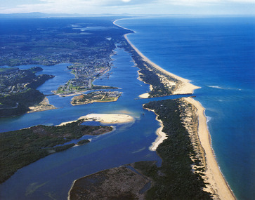
... Lakes Entrance Historical Society 4 Marine Parade Lakes Entrance gippsland Photo was cut from Tourist brochure Bridges Coast Waterways Topography Township Colour photograph showing aerial view of township and the Ninety Mile Beach. Pecks factory on Bullock Island, Old North Arm bridge, bitumen for carpark for future. Fishermen's Club near North Arm Bridge. Photo shows east end of Rigby Island and Snake Island. Glimpse of Red Bluff, Lake Bunga and Lake Tyers ...Photo was cut from Tourist brochureColour photograph showing aerial view of township and the Ninety Mile Beach. Pecks factory on Bullock Island, Old North Arm bridge, bitumen for carpark for future. Fishermen's Club near North Arm Bridge. Photo shows east end of Rigby Island and Snake Island. Glimpse of Red Bluff, Lake Bunga and Lake Tyers in far east. Lakes Entrance Victoriabridges, coast, waterways, topography, township -
 Lakes Entrance Historical Society
Photograph - St John Star, 1981
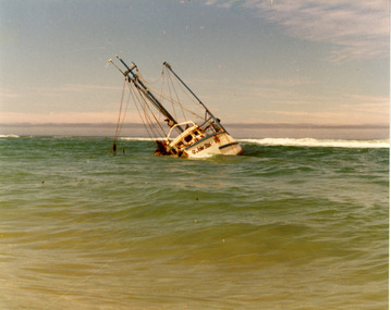
... Lakes Entrance Historical Society 4 Marine Parade Lakes Entrance gippsland Date made 13 August 1981 Fishing Industry Ships and Shipping Waterways Shipwrecks Colour photograph of the fishing boat St John Star aground between breakers and shoreline, 20 km east of Lakes Tyers, near Lakes Entrance, Victoria. ...Date made 13 August 1981Colour photograph of the fishing boat St John Star aground between breakers and shoreline, 20 km east of Lakes Tyers, near Lakes Entrance, Victoria.fishing industry, ships and shipping, waterways, shipwrecks -
 Lakes Entrance Historical Society
Photograph - Mary Bernadette, 1985
... Lakes Entrance Historical Society 4 Marine Parade Lakes Entrance gippsland Vessel went ashore 12 March 1985 Fishing Industry Ships and Shipping Ocean Shipwrecks Colour photograph of the concrete hull fishing boat Mary Bernadette wrecked on the beach five kilometers east of Lake Tyers, after going ashore 12 March 1985. ...Vessel went ashore 12 March 1985Colour photograph of the concrete hull fishing boat Mary Bernadette wrecked on the beach five kilometers east of Lake Tyers, after going ashore 12 March 1985. Lakes Entrance Victoriafishing industry, ships and shipping, ocean, shipwrecks -
 Lakes Entrance Historical Society
Photograph - Kieth Bryce, Bryce, Anne, 1981
... Lakes Entrance Historical Society 4 Marine Parade Lakes Entrance gippsland Date made 13 August 1981 Fishing Industry Ships and Shipping Shipwrecks Colour photograph showing Keith Bryce inspecting the remains of the wrecked St John Star which became stranded in fog fourteen kilometres east of Lake Tyers, near Lakes Entrance, Victoria. ...Date made 13 August 1981Colour photograph showing Keith Bryce inspecting the remains of the wrecked St John Star which became stranded in fog fourteen kilometres east of Lake Tyers, near Lakes Entrance, Victoria.fishing industry, ships and shipping, shipwrecks -
Lakes Entrance Historical Society
Map - Tourist Information Map Sale to Lake Tyers, Department of Sport and Recreation East Gippsland and Region, 2000
... Lakes Entrance Historical Society 4 Marine Parade Lakes Entrance gippsland Tourism Information East Gippsland's Water Paradise Victoria's Riviera Tourist information map from Sale to Lake Tyers Map Tourist Information Map Sale to Lake Tyers Department of Sport and Recreation East Gippsland and Region South East Coast Tourism Ltd. ...Tourist information map from Sale to Lake TyersEast Gippsland's Water Paradise Victoria's Rivieratourism, information -
Lakes Entrance Historical Society
Map - Colquhoun East County Tambo, Government Printer
... Lakes Entrance Historical Society 4 Marine Parade Lakes Entrance gippsland Waterways Aboriginal history Settlement Map of Lake Tyers forest showing Aboriginal Reserve and Land owners Map Colquhoun East County Tambo Government Printer ...Map of Lake Tyers forest showing Aboriginal Reserve and Land ownerswaterways, aboriginal history, settlement -
 Lakes Entrance Historical Society
Photograph - Oneonta Lake Tyers Beach Victoria, 2016 c
... Oneonta was donated to Lake Tyers community later aquired by East Gippsland Shire...Lakes Entrance Historical Society 4 Marine Parade Lakes Entrance gippsland Oneonta was donated to Lake Tyers community later aquired by East Gippsland Shire Houses Settlers Parks Colour photograph of grounds of Oneonta former property of Jack and Dylas Ramsdell Lake Tyers Beach Victoria. ...Oneonta was donated to Lake Tyers community later aquired by East Gippsland ShireColour photograph of grounds of Oneonta former property of Jack and Dylas Ramsdell Lake Tyers Beach Victoria. Plus 4 other photoshouses, settlers, parks -
Lakes Entrance Historical Society
Map - Colquhoun East and Tildesley West
... Lakes Entrance Historical Society 4 Marine Parade Lakes Entrance gippsland Tildesley West is Lake Tyers area Waterways Aboriginal history Settlement County of Tamo Map of Colquhoun East and Tildesley West 3 pages Map Colquhoun East and Tildesley West ...Tildesley West is Lake Tyers areaMap of Colquhoun East and Tildesley West 3 pagesCounty of Tamowaterways, aboriginal history, settlement -
Lakes Entrance Historical Society
Map - Map Colquhoun East Counties of Tambo and Tanjil
... Lakes Entrance Historical Society 4 Marine Parade Lakes Entrance gippsland land owners Townships Topography Map shows allotments with land owners names Lake Tyers, Tildesley West, Township of East Cunninghame, Red Bluff. 2 pages filed 10444 and 10444.1 Map Map Colquhoun East Counties of Tambo and Tanjil ...Map shows allotments with land owners names Lake Tyers, Tildesley West, Township of East Cunninghame, Red Bluff. 2 pages filed 10444 and 10444.1land owners, townships, topography -
Lakes Entrance Historical Society
Map - Tildesley West County of Tambo, A C Brooks Govv. Printer, 1965
... Lakes Entrance Historical Society 4 Marine Parade Lakes Entrance gippsland Waterways land owners Settlement Map shows Nowa Nowa Arm in Lake Tyers, Colquhoun East, land owners, Bass Strait, Ninety Mile Beach. ...Map shows Nowa Nowa Arm in Lake Tyers, Colquhoun East, land owners, Bass Strait, Ninety Mile Beach.waterways, land owners, settlement -
Lakes Entrance Historical Society
Map - Tildesley West Sheet 2, A C Brooks Gov. Printer, 1965
... Lakes Entrance Historical Society 4 Marine Parade Lakes Entrance gippsland land owners Waterways Settlement Map shows North Arm Lake Tyers, Colquhoun East land owners. ...Map shows North Arm Lake Tyers, Colquhoun East land owners.land owners, waterways, settlement