Showing 922 items matching "land subdivision"
-
 Whitehorse Historical Society Inc.
Document, Land Subdivision Policy, 24/08/1998 12:00:00 AM
... Land Subdivision Policy...land subdivision...Land subdivision policy: approved by City... Mitcham melbourne A4 2p land subdivision city of whitehorse Land ...Land subdivision policyLand subdivision policy: approved by City of Whitehorse.Ordinary council meeting 24/8/1998, Item 12.1.5 p. 42-43Land subdivision policyland subdivision, city of whitehorse -
 Ringwood and District Historical Society
Envelope, Nunawading, Ringwood, East Ringwood Land Subdivision Sales, and Grid Map of Melbourne
... Nunawading, Ringwood, East Ringwood Land Subdivision Sales...Land Subdivision Sales - Nunawading; Land Subdivision Sales... Road Ringwood North melbourne Land Subdivision Sales ...Land Subdivision Sales - Nunawading; Land Subdivision Sales - East Ringwood; Land Subdivision Sales - Ringwood; Land Subdivision Sales - Grid map of Melbourne -
 Ringwood and District Historical Society
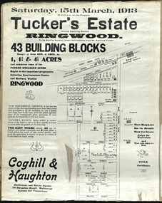
Card - Land Subdivision Clipping, Tucker's Estate, Ringwood, Vic. - 1913
... Land Subdivision Clipping...Partially trimmed copy of a land subdivision auction... Street, Melbourne. Partially trimmed copy of a land subdivision ...Partially trimmed copy of a land subdivision auction advertisement on cardboard backing, with digitised copy of original flyer.Subdivision includes Thanet Street, Albert Street, Arlington Street, Barkly Street, Maidstone Street, Kirk Street, Vine Street, Surrey Street, Yarmouth Street and West Prussia Road (later Wantirna Road) Ringwood, Vic. Property names include Wandsworth, Ingleside, Lyndhurst and Karsruhe. Auctioneer and Estate Agents - Coghill & Haughton, 79 Swanston Street, Melbourne Auburn and Canterbury. Licensed Surveyor - W.P. Steane, M.C.E., 317 Collins Street, Melbourne. -
 Whitehorse Historical Society Inc.
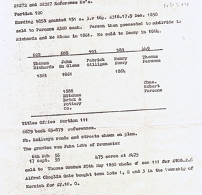
Document, Land subdivision, n.d
... Land subdivision...land subdivision... Mitcham melbourne land subdivision richards thomas mcglone john ...notes of records of land dealings in parts of Crown Portions 120 and 111, 1858 - 1886.Photocopy of notes of records of land dealings in parts of Crown Portions 120 and 111, 1858 - 1886. notes of records of land dealings in parts of Crown Portions 120 and 111, 1858 - 1886.land subdivision, richards, thomas, mcglone, john, gilligan, patrick, emery, henry, parsons, charles robert, lobb, graham, gale, alfred chaplin, mitcham brick and pottery co. ltd -
Whitehorse Historical Society Inc.
Document, Land Subdivision, cnr Springvale and Burwood Roads, n.d
... Land Subdivision, cnr Springvale and Burwood Roads...Hand drawn document of land subdivision, Springvale Road... subdivision, Hand drawn document of land subdivision, Springvale Road ...Hand drawn document of land subdivision,Hand drawn document of land subdivision, Springvale Road & Burwood Road, together with notes of various sales from 1857 to 1957.Hand drawn document of land subdivision, burwood road, vermont south, springvale road, vermont south, stanley road, vermont south, vermont south, mayne, alexander, mayne, james alexander, craig, silas gordon, fankhauser, frederick william, fankhauser, mervyn william, burrell, charles, donaldson, john -
Whitehorse Historical Society Inc.
Article, Council rules for land subdivisions, 1976
... Land subdivision...'Know your Council' stating rules and procedures for land... Mitcham melbourne City of Nunawading Land subdivision 'Know your ...'Know your Council' stating rules and procedures for land subdivision.'Know your Council' stating rules and procedures for land subdivision.'Know your Council' stating rules and procedures for land subdivision.city of nunawading, land subdivision -
Tatura Irrigation & Wartime Camps Museum
Poster, Subdivision of Township Allotments
... land subdivision... of land subdivision...., laminated. Advertising land subdivision for sale in the township ...Poster depicting the land which was being sold by J S Darby on the 3 December 1890. Auctioneer was Martin Cussen and Co. Map shows location of land.Single sheet of paper, laminated. Advertising land subdivision for sale in the township of Rushworth. Being sold by Martin Cussen and Co, auctioneers for J S Darby. Shows map of land subdivision.rushworth, land subdivision, martin cussen and co, j s darby -
 Ringwood and District Historical Society
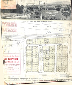
Card - Land Subdivision Clipping, Heatherdale Station Estate, Ringwood, Vic. - circa 1923
... Land Subdivision Clipping... Estate, Ringwood, Vic. - circa 1923 Card Land Subdivision ...Cardboard-backed partial front page copy of a land sale advertisement map with penciled sales notations for some blocks.Subdivision includes Heatherdale Road, Molan Street, Yallourn Parade, Newman Street, and Madden Street. Location map inset shows Purches Street and Forster Street, Mitcham, and approved site for Heatherdale railway station. -
Whitehorse Historical Society Inc.
Newspaper - Article, Residents fear for streetscape, 28/09/1994
... Land Subdivision...,' (Walker home), Meerut Street, Mitcham, land subdivision opposite.... Australian Tesselated Tile Co Pty Ltd Barelli Ken Land Subdivision ...'Residents fear for streetscape' ' Mitcham Mansion,' (Walker home), Meerut Street, Mitcham, land subdivision opposite.meerut street, mitcham, walker, edgar edwardes, australian tesselated tile co pty ltd, barelli, ken, land subdivision -
 Whitehorse Historical Society Inc.
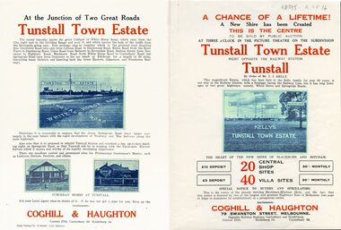
Legal record - Document, Tunstall Town Estate
... land subdivision...Land subdivision at Tunstall 1926 bounded by Springvale... Mitcham melbourne land subdivision springvale road nunawading ...Land subdivision at Tunstall 1926 bounded by Springvale Road, Whitehorse Road, Railway Parade.Land subdivision at Tunstall 1926 bounded by Springvale Road, Whitehorse Road, Railway Parade. Original in Haughton Maps LaTrobe LibraryLand subdivision at Tunstall 1926 bounded by Springvale Road, Whitehorse Road, Railway Parade. land subdivision, springvale road, nunawading, railway parade, kelly, j, nunawading state school, no. 4190, shire of blackburn and mitcham, whitehorse road, silver grove, glendale street -
 Ringwood and District Historical Society
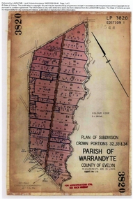
Document, Titles of land subdivision, Crown Portions 32, 33 & 34, Parish of Warrandyte, 1884 and 1907, Ringwood, Victoria
... Titles of land subdivision, Crown Portions 32, 33 & 34... to 1921. Titles of land subdivision, Crown Portions 32, 33 & 34 ...Evolution of the subdivision and the use of landBlack plastic bound pockets containing copies of 18 LANDATA subdivision maps and mortgage transfer pages dating from 1884 for 303 acres 2 roods and 1 perch bounded by Warrandyte Road, Wonga Road, Oban Road and Mullum Mullum Creek in Ringwood, Victoria. Certificates of Title include Vol 1606 Fol 045 Frederick Walter Purches 1884 and subsequent transfers to 1902, and Vol 3232 Fol 646357 Ann Jane Kennedy 1907 and transfers to 1921. -
 Whitehorse Historical Society Inc.
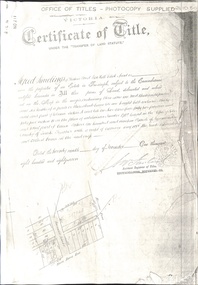
Document - Land Title, Certificate of Title, 29/11/1887
... land subdivision...Photocopies of land titles involved in subdivision of land... george henry mitcham primary school no. 2904 land subdivision ...Photocopies of land titles involved in subdivision of land on the north-west corner of Whitehorse Road and Mitcham Road including Britannia Street. A list of purchasers is included.mitcham road, mitcham, whitehorse road, britannia street, rawlings, alfred, frost, john, richards, thomas, leech, george arthur, smith, reed, richard louis, young, frederick, hughes, doery, george henry, mitcham primary school, no. 2904, land subdivision -
 Kew Historical Society Inc
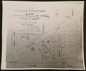
Plan - Framed Subdivision Plan (copy), F Price, Plan of Mr William Derrick's Land, Kew being Subdivision of Part of Section 86, Parish of Boroondara, County of Bourke, 1872, 1872
... Plan of Mr William Derrick's Land, Kew being Subdivision of... Land, Kew being Subdivision of Part of Section 86, Parish.... ‘Plan of Mr Willia Derrick's Land, Kew being Subdivision of Part ...William Derrick was an early landowner in Kew, and with James Venn Morgan and James Dannock the purchaser of the parcel of land bounded by Cotham Road, High Street and Mary Street. Derrick Street in Kew is named after him.Map mounted under perspex. ‘Plan of Mr Willia Derrick's Land, Kew being Subdivision of Part of Section 86, Parish of Boroondara, County of Bourke’. This is a copy of the plan held in the State Library of Victoria.kew subdivision plan, john derrick, subdivision plans -- kew (vic.) -
 Whitehorse Historical Society Inc.
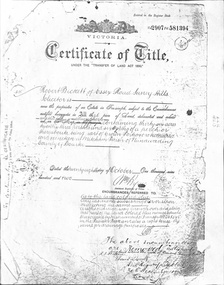
Document - Land Title, Certificate of Title, 28/10/1902
... land subdivision... by Robert Becket. Transfers of land through subdivision... samuel land subdivision Certificate of Title for land between ...Certificate of Title for land between Ormond Avenue, Fellows Street, Victoria Avenue and Mitcham Road, Mitcham owned by Robert Becket. Transfers of land through subdivision are included.whitehorse road, mitcham, mitcham road, ormond avenue, victoria avenue, gillies street, deakin street, fellows street, haines street, purches street, albert street, edward street, britannia street, beckett, robert, johnson, catherine, bewley, william, londgerin, mary, chugg, william harold, wheeler, sarah, byrne, bedson, samuel, land subdivision -
Whitehorse Historical Society Inc.
Document, Canterbury Road estate, Unknown
... land subdivision...Plan of subdivision of land for sale in Canterbury Road... Mitcham melbourne land subdivision canterbury road estate ...Plan of subdivision of land for sale in Canterbury Road estate, Blackburn.land subdivision, canterbury road estate, blackburn, main street, norvel street, kalka street, arna street, lalwa street, ronley street, eustace street -
 Inverloch Historical Society
000080 - Photograph - Parcel of land fo subdivision on Toorak Rd between Ullathorne Road and Florida Avenue - R Young
... 000080 - Photograph - Parcel of land fo subdivision on...) Inverloch gippsland 000080 - Photograph - Parcel of land fo ... -
Whitehorse Historical Society Inc.
Article, Too many industries, 1990
... Land subdivision...Article about subdivision of land of Wunderlich Monier... Mitcham melbourne Land subdivision Mitcham Road Vermont Rooks Road ...Article about subdivision of land of Wunderlich Monier, showing that this would increase the number of industries in the area.Article about subdivision of land of Wunderlich Monier, showing that this would increase the number of industries in the area.Article about subdivision of land of Wunderlich Monier, showing that this would increase the number of industries in the area.land subdivision, mitcham road vermont, rooks road vermont, wunderlich limited -
Glen Eira Historical Society
Article - Shoobra Road, 52, Elsternwick, 'Wee Nestie'
... Land subdivision... gives a brief history of land subdivision and local tenants... Shoobra Road. Document gives a brief history of land subdivision ...Four items about this property: One typed document and its handwritten document of working notes on 52 Shoobra Road. Document gives a brief history of land subdivision and local tenants and owners of number 52 Shoobra Road by Brighton Historical Society One typed letter to J Atkin form Brighton Historical Society One photocopied typed letter to Rosalind Landells from Jenni Atkin dated 24/05/1993 Domain.com.au advertisement giving details for upcoming auction of the property on 08/09/2013. Includes 4 photographs of property.riddell john carre, pioneers, elsternwick, cavers carre, caulfield, hamilton thomas ferrier jp, land subdivision, hamilton street, shoobra road, wee nestie, ettrick, deeside, cerutty peter, cerutty lem mrs, kirby charles p, kirby charles f, landells rosalind, bullock hilary, atkin jenni mrs, house names, timber houses, edwardian style, noel jones real estate, brukarz jack, real estate agents, ashton daniel, stavrakis bill, lead lights, verandahs -
 Whitehorse Historical Society Inc.
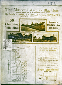
Document, Mascot Estate Blackburn
... land subdivision...Subdivision of land surrounded by Whitehorse Road, Simla... Mitcham melbourne land subdivision mascot estate blackburn ...Subdivision of landSubdivision of land surrounded by Whitehorse Road, Simla street and King Street. 50 villa sites auctioned by M.Pullyn & Frank FisherSubdivision of land land subdivision, mascot estate blackburn, whitehorse road, blackburn, iona street, king street, simla street, pullyn, m, frank fisher & co. -
Whitehorse Historical Society Inc.
Map, Subdivision of Allotment 122a, 1972
... Land Subdivision...Subdivision of land along Livermore Close and Moore Road.... Land Subdivision Livermore Close Vermont South Moore Road ...Subdivision of land along Livermore Close and Moore Road, Vermont South.Subdivision of land along Livermore Close and Moore Road, Vermont South. Original survey Rob Poole 1899. Stamp indicates 'Land on this plan is in proclaimed survey No 21. Survey Coordination Act 1940. As from 9 Aug 1972. Two maps in different scales.Subdivision of land along Livermore Close and Moore Road, Vermont South. land subdivision, livermore close, vermont south, moore road, vermont south, dandenong creek -
 Kew Historical Society Inc
Print - Subdivision Plan, F Price, Plan of Mr William Derrick's Land, Kew being Subdivision of Part of Section 86, Parish of Boroondara, County of Bourke, 1872, 1872 [Original]
... Plan of Mr William Derrick's Land, Kew being Subdivision of... derrick subdivision plans -- kew (vic.) A photographic ...This work forms part of the collection assembled by the historian Dorothy Rogers, that was donated to the Kew Historical Society by her son John Rogers in 2015. The manuscripts, photographs, maps, and documents were sourced by her from both family and local collections or produced as references for her print publications. Many were directly used by Rogers in writing ‘Lovely Old Homes of Kew’ (1961) and 'A History of Kew' (1973), or the numerous articles on local history that she produced for suburban newspapers. Most of the photographs in the collection include detailed annotations in her hand.The Rogers Collection provides a comprehensive insight into the working habits of a historian in the 1960s and 1970s. Together it forms the largest privately-donated collection within the archives of the Kew Historical Society.A photographic reproduction of a plan in the Vale Collection of the State Library of Victoria showing William Derricks land in the area bordered by Bulleen Road (High Street); Cotham Road and Union Street. The plan dates from 1872.william derrick, subdivision plans -- kew (vic.) -
 Greensborough Historical Society
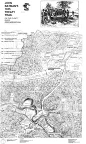
Map, Dennis Ward, John Batman's 1835 Treaty Trail on the Plenty River, 2010_
... Large laminated map, including land subdivisions and street..., including land subdivisions and street names. John Batman's 1835 ...Map of the Plenty River through Greensborough and surrounding areas, annotated with historic places. Prepared by Dennis Ward, this map shows places of interest with historic markers for a proposed Heritage Trail along the Plenty. This was a joint project of Dennis Ward, Rotary Greensborough and Nillumbik Historical Society.This map shows many places of interest along the Plenty River. Large laminated map, including land subdivisions and street names.plenty river heritage trail -
 Ringwood and District Historical Society
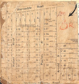
Map, Residential Subdivision Allotment Layout on Mullum Mullum Road, Hobart Street, Paxton Street, Arnold Street and Warrandyte Road, Ringwood, Vic. circa 1920
... One of 3 unrelated land subdivision maps on cardboard..., Melbourne. One of 3 unrelated land subdivision maps on cardboard ...One of 3 unrelated land subdivision maps on cardboard backing.H.C. Crouch, Licensed Surveyor, 443 Lt Collins Street, Melbourne. -
 Whitehorse Historical Society Inc.
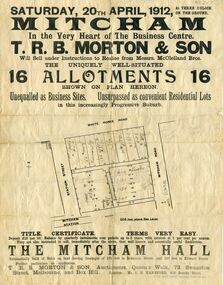
Document, Mitcham Hall, 1912
... land subdivision...Advertising poster relating to the Subdivision of land... Mitcham melbourne mitcham hall land subdivision t. r. b. morton ...Subdivision of landAdvertising poster relating to the Subdivision of land surrounded by Mitcham Station, Station Street, Whitehorse Road and Mitcham Road, for sale by auction Saturday 20th April 1912 under instructions from Messrs. McLelland Bros.. Also the sale of Mitcham Hall. Auctioneers T.R.B. Morton, Melbourne and Box Hill. Hall used by Girl Guides until its demolition in 1988.Subdivision of land mitcham hall, land subdivision, t. r. b. morton & son, station street mitcham, mitcham road, mitcham, whitehorse road mitcham, mclelland bros. -
 Ringwood and District Historical Society
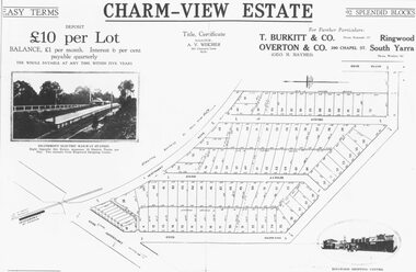
Photograph, Land sale advertisement for Charm View Estate, Heathmont - 1927
... Typed below photograph, "From 1927 land subdivision... 1927 land subdivision brochure". Map - Charm-View Estate Land ...Map - Charm-View EstateTyped below photograph, "From 1927 land subdivision brochure". -
Glen Eira Historical Society
Document - Helenslea, Shelford CEGGS
... Land subdivision... St Mary’s Church Caulfield North Land subdivision Land ...Three copies of a photocopied fold out brochure for the auction of Helenslea mansion and stables on 25/03/1916 in association with the sale of the adjoining allotments of the Helenslea Estate. The brochure includes a map of the Helenslea Estate, a photograph of the view from Helenslea Mansion, an illustration of the exterior of the Mansion and a detailed floor plan of the Mansion and stables.helenslea mansion, helenslea estate plan, glen eira road, hood crescent, merton street, stables, hawthorn road, orrong road, morrice street, helenslea road, st kilda east, auctions, st mary’s church, caulfield north, land subdivision, land brochures, residential development -
Glen Eira Historical Society
Document - Helenslea, Shelford CEGGS
... Land subdivision... Church Land subdivision Land brochures Residential development ...Three copies of a photocopied fold out brochure relating to the auction of 48 lots in the Helenslea Estate on 25/03/1916. The brochure references St Mary’s Church, shops on Glen Eira Road, Caulfield Grammar School, and existing homes in the vicinity and includes photographs of these localities. Reference is also made to available public transport and trees on the Estate. The brochure also includes an illustrated bird’s eye map of the Estate.helenslea estate, glen eira road, st kilda east, mansions, orrong road, balaclava road, caulfield grammar school, fosberry avenue, st mary’s church, land subdivision, land brochures, residential development, auctions, caulfield north -
Glen Eira Historical Society
Plan - Nettalie
... Land subdivision... Grammar School Land subdivision Land sales Land titles Legal ...Land Victoria title documents vol 339 folio 763A and 764 relating to the property Nettalie on the corner of Balaclava and Orrong Rds. These documents detail the history of the land dealing relating to Nettalie and the neighbouring estate Harleston listed as parcels 209a and 209b. These dealing include grants of land, mortgages and conveyance (transfers). The documents include photocopies of handwritten notes of the title history date 1870; a partial copy of an instrument of conveyance dated 1863 and the original titles of the land owned at various times by William Noall, Alfred Shaw, Alfred Desailly and Sir Frederick Grimwade. Within the documents are various hand drawn and printed diagrams of the subdivisions.forsyth william, noall william, cutts william henry, shaw alfred, hailes george button, bakewell john, pascoe john randle, little william, fraser alexander, powell walter, whitney john, hodgeson richard, trollope william thomas, keep edward, blundell mary, carr john bonney, farie claud, fosberry john wallcott, davies john, brady michael, lloyd frederick, turner george, desailly alfred, grimwade frederick s sir, parish of prahran, county of bourke, caulfield north, st kilda east, balaclava road, orrong road, nettalie, netley house, harleston, melbourne grammar school, land subdivision, land sales, land titles, legal documents, homestead, schools, houses -
Glen Eira Historical Society
Document - LAND SUBDIVISIONS 1880-1938
... Land subdivision... 21cm) Auctions House auctions Land subdivision Land development ...This file contains various subdivisions’ advertising flyers and cards. 1/Advertising announcement for auction sale of land (15 lots) at Glenhuntly Tram Terminus, to be held on 29/03/1924. Verso is map of the area (21.5cm x 29cm) 2/Advertising announcement for Trustees’ Auction sale of corner shop sites at Caulfield South near Glenhuntly Road and Hawthorn Roads, 15/11/1927 (21cm x 31cm) 3/Advertising pamphlet (A3) for auction of Cantala Estate, East St. Kilda (32 allotments), between Dandenong, Waiora, and Alma Roads, 21/05/1938 (15.5cm x 28.5cm) 4/Seven advertising postcards relating to auctions of land in Caulfield and Elsternwick. Only one (10 December 1881) with a year on it. (Each 13.5cm x 9cm) 5/Four more advertising postcards relating to auctions of land in Caulfield. One is dated 31/11/1880(?); another 09/02/1905. A third has no date. A fourth postcard is a map of allotments between Orrong, Kooyong, Seymour and Alison Roads, Caulfield, no date (each 13.5cm x 9cm) 6/Large advertising poster (41cm x 52.5cm) for ‘Carnegie Land Sale’ auction of the Egan Estate (near Carnegie Railway Station) on 12 April, no year given, but appears to be circa1900 7/‘Riddell Estate – Plan of Subdivision – Parish of Prahran’ mounted map, no date, probably c. 1900 (16cm x 21cm)auctions, house auctions, land subdivision, land development, subdivisions, caulfield, land subdivisions, east st. kilda, glenhuntly, carnegie, map, ‘new glenhuntly tram terminus estate’, ‘cantala estate’, ‘strathnaver estate’, ‘range estate’, ‘egan estate’, ‘riddell estate’ -
 Glen Eira Historical Society
Document - Thomas, George
... Land subdivision... Land subdivision Land sales Land prices Land development Land ...This file contains three items Hand written report on property of George Thomas in Orrong Road, dated 04/06/1985, author unknown Photocopy of four page contract and conditions of sale for lot 262 county of Burke Parish of Prahran. George Thomas property was sold to George William Taylor, dated 20/10/1881 The original photograph of a water colour painting of home and garden of George Thomas, Orrong Road, Caulfield by W. Tibbits 1876thomas eric f, thomas george, beemery park, orrong road, seymour road, allison road, mullaly j, j. fulton, taylor george william, warrein road, north road, stone adelaide, orrong road t. fulton, business, farmers, farm workers, farms, gardeners, subdivisions, land subdivision, land sales, land prices, land development, land developers