Showing 13 items matching "land and water protection"
-
 Bendigo Historical Society Inc.
Booklet - Kangaroo Flat Gold Mine Collection: Environmental Trust Fund Policy booklet
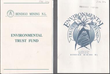
... ...land and water protection...Preference was given to projects that reflected the philosophy of the Bendigo Region Conservation Strategy, namely flora and fauna, energy conservation, land and water protection and waste management. ...Preference was given to projects that reflected the philosophy of the Bendigo Region Conservation Strategy, namely flora and fauna, energy conservation, land and water protection and waste management. ...The Bendigo Environmental Trust was established in 1995 with funds provided by Bendigo Mining NL. The Trust was administered by an honorary Board of Trustees. Preference was given to projects that reflected the philosophy of the Bendigo Region Conservation Strategy, namely flora and fauna, energy conservation, land and water protection and waste management. Two copies of an eight-page booklet titled ' Environmental Trust Fund, sponsored by Bendigo Mining NL. One booklet date stamped 4 Sep 2002. Content identical in both: policy; how the Bendigo Mining Environmental Trust works; who can apply; areas supported; how to apply; preferred format; limitations of grants; support period; when to apply, where to apply and project documentation required.Date stamp September 2005 on one copy.bendigo mining nl, environment, environmental trust, flora and fauna, energy conservation, waste management, land and water protection, kangaroo flat, goldmining -
 Marysville & District Historical Society
Flyer (Item) - Information Flyer, Forests Commission, Victoria, FOREST WALKS - MARYSVILLE, 1918-1983
... The Commission was responsible for ″forest policy, prevention and suppression of bushfires, issuing leases and licences, planting and thinning of forests, the development of plantations, reforestation, nurseries, forestry education, the development of commercial timber harvesting and marketing of produce, building and maintaining forest roads, provision of recreation facilities, protection of water, soils and wildlife, forest research and making recommendations on the acquisition or alienation of land for forest purposes″. ...The Commission was responsible for ″forest policy, prevention and suppression of bushfires, issuing leases and licences, planting and thinning of forests, the development of plantations, reforestation, nurseries, forestry education, the development of commercial timber harvesting and marketing of produce, building and maintaining forest roads, provision of recreation facilities, protection of water, soils and wildlife, forest research and making recommendations on the acquisition or alienation of land for forest purposes″. ...An information flyer that was produced as a guide to the forest walks in and near Marysville by the Forests Commission of Victoria. The Forests Commission Victoria (FCV) was the main government authority responsible for management and protection of State forests in Victoria, Australia between 1918 and 1983. The Commission was responsible for ″forest policy, prevention and suppression of bushfires, issuing leases and licences, planting and thinning of forests, the development of plantations, reforestation, nurseries, forestry education, the development of commercial timber harvesting and marketing of produce, building and maintaining forest roads, provision of recreation facilities, protection of water, soils and wildlife, forest research and making recommendations on the acquisition or alienation of land for forest purposes″. An extensive network of walking tracks surrounds Marysville and they offer a variety of walks ranging in various levels of difficulty. This information flyer provides information such as the level of difficulty for six suggested walks around Marysville.An information flyer that was produced as a guide to the forest walks in and near Marysville by the Forests Commission of Victoria.marysville, victoria, australia, forest walks, forests commission victoria, beauty spot walk, tree fern gully walk, michaeldene track, keppel track, woods lookout track -
 Marysville & District Historical Society
Flyer (item) - Information Flyer, Forests Commission, Victoria, Cumberland Scenic Reserve, 1918-1983
... The Commission was responsible for ″forest policy, prevention and suppression of bushfires, issuing leases and licences, planting and thinning of forests, the development of plantations, reforestation, nurseries, forestry education, the development of commercial timber harvesting and marketing of produce, building and maintaining forest roads, provision of recreation facilities, protection of water, soils and wildlife, forest research and making recommendations on the acquisition or alienation of land for forest purposes″. ...The Commission was responsible for ″forest policy, prevention and suppression of bushfires, issuing leases and licences, planting and thinning of forests, the development of plantations, reforestation, nurseries, forestry education, the development of commercial timber harvesting and marketing of produce, building and maintaining forest roads, provision of recreation facilities, protection of water, soils and wildlife, forest research and making recommendations on the acquisition or alienation of land for forest purposes″. ...An information flyer that was produced as a guide to the Cumberland Scenic Reserve by the Forests Commission of Victoria. The Forests Commission Victoria (FCV) was the main government authority responsible for management and protection of State forests in Victoria, Australia between 1918 and 1983. The Commission was responsible for ″forest policy, prevention and suppression of bushfires, issuing leases and licences, planting and thinning of forests, the development of plantations, reforestation, nurseries, forestry education, the development of commercial timber harvesting and marketing of produce, building and maintaining forest roads, provision of recreation facilities, protection of water, soils and wildlife, forest research and making recommendations on the acquisition or alienation of land for forest purposes″. The Cumberland Scenic Reserve is set in the heart of the mountain forests of Victoria and is 16km east of Marysville on the Cumberland Road. This reserve forms part of the catchment of Armstrong Creek, a tributary of the Yarra River which provides water for the Melbourne area. The reserve is a prime mountain ash area in which is set the old Cambarville sawmill and village site.An information flyer that was produced as a guide to the Cumberland Scenic Reserve by the Forests Commission of Victoria. 423Aforests commission victoria, cumberland scenic reserve, marysville, victoria, cambarville, the big tree, cora-lyn falls, barton's lookout, cumberland falls, sovereign view, armstrong creek, yarra river, mountain ash -
 Department of Energy, Environment and Climate Action
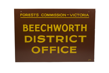
Beechworth FCV District office sign
... The Commission was responsible for ″forest policy, prevention and suppression of bushfires, issuing leases and licences, planting and thinning of forests, the development of plantations, reforestation, nurseries, forestry education, the development of commercial timber harvesting and marketing of produce, building and maintaining forest roads, provision of recreation facilities, protection of water, soils and wildlife, forest research and making recommendations on the acquisition or alienation of land for forest purposes″. ...The Commission was responsible for ″forest policy, prevention and suppression of bushfires, issuing leases and licences, planting and thinning of forests, the development of plantations, reforestation, nurseries, forestry education, the development of commercial timber harvesting and marketing of produce, building and maintaining forest roads, provision of recreation facilities, protection of water, soils and wildlife, forest research and making recommendations on the acquisition or alienation of land for forest purposes″. ...This sign proudly hung outside the Forests Commission Victoria (FCV) Beechworth office which is now site of the Forestry Heritage Museum. The granite building in the Beechworth's historic precinct was once the Gold Warden's Office and is one of the town's original buildings. The FCV was the main government authority responsible for management and protection of State forests in Victoria between 1918 and 1983. The Commission was responsible for ″forest policy, prevention and suppression of bushfires, issuing leases and licences, planting and thinning of forests, the development of plantations, reforestation, nurseries, forestry education, the development of commercial timber harvesting and marketing of produce, building and maintaining forest roads, provision of recreation facilities, protection of water, soils and wildlife, forest research and making recommendations on the acquisition or alienation of land for forest purposes″. The Forests Commission had a long and proud history of innovation and of managing Victoria's State forests but in September 1983 lost its discrete identity when it was merged into the newly formed Victorian Department of Conservation, Forests and Lands (CFL) along with the Crown Lands and Survey Department, National Park Service, Soil Conservation Authority and Fisheries and Wildlife Service. After the amalgamation the management of State forests and the forestry profession continued but the tempo of change accelerated, with many more departmental restructures occurring over the subsequent four decades. Responsibilities are currently split between the Department of Energy, Environment and Climate Action (DEECA), Forests Fire Management Victoria (FFMV), Parks Victoria, Melbourne Water, Alpine Resorts Commission, the State Government-owned commercial entity VicForests and the privately owned Hancock Victorian Plantations (HVP).Large office sign. Hand painted in traditional FCV mission brown and gold colour scheme.forests commission victoria (fcv), forest signs -
 Eltham District Historical Society Inc
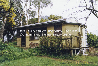
Photograph - Colour Print, Alan Marshall's bungalow, 13 Park West Road, Eltham, 22 July 1993
... A copy of the gazetted Amendment is available on website of the Department of Environment, Land, Water and Planning at www.planning.vic.gov.au/schemes-and-amendments/browse-amendments. ...From 1955 Alan Marshall's home was a bungalow at the rear of his sister's house at Eltham. The first bungalow burnt down. Its replacement shown here still stands. In March 2020 the property was sold. It was last sold previously in November 1982. No mention was made in the advertising regarding the heritage protected bungalow in the rear yard and advertising material presented it as having future potential to develop STCA (Subject To Council Approval). Concerned local members of the community alerted to EDHS to the pending upcoming sale and Council was also alerted to the sale and the potential risk presented to the heritage protected bungalow. In 2021 an updated amendment, C133nill, was made to the Nillumbik Planning Scheme in response to a planning application to develop the property following its sale. The Minster of Planning approved and gazetted the Amendment. Gazettal occurred on 25th November 2021. A copy of the gazetted Amendment is available on website of the Department of Environment, Land, Water and Planning at www.planning.vic.gov.au/schemes-and-amendments/browse-amendments. It was last updated March 2022.Colour photo print 10 x 15 cm, originally stuck down on corflute for displayeltham, alan marshall, alan marshall bungalow, heritage assessment, heritage protection overlay, houses, nillumbik shire council, park west road, heritage overlay ho147 -
 Eltham District Historical Society Inc
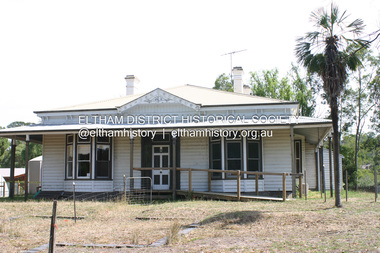
Photograph - Digital Photograph, Alan King, Edendale Farm Homestead, 29 January 2008
... Cool did not farm the land, instead using it as a gentleman’s residence, retiring to Eltham at weekends. ...Cool did not farm the land, instead using it as a gentleman’s residence, retiring to Eltham at weekends. ...Edendale Farm is Nillumbik Shire Council's environment centre situated in Gastons Road, Eltham between the railway and the Diamond Creek. The homestead on the property was built in 1896 and is of historical significance, being the subject of a Heritage Overlay under the Nillumbik Planning Scheme. The Edendale property was originally part of an extensive land purchase in 1852 from the Crown by pioneer Eltham farmer Henry Stooke. He initially purchased 51 acres and later expanded his holdings by purchasing another three adjacent Crown allotments extending northerly from Josiah Holloway's Little Eltham subdivision. Despite clearing the land, Stooke did not build on this property, choosing to live on his property "Rosehill" at Lower Plenty. In 1896 Thomas Cool, Club Manager of the Victoria Coffee Palace in Melbourne purchased 7 acres of the original Stooke land and built the house now known as Edendale. Cool did not farm the land, instead using it as a gentleman’s residence, retiring to Eltham at weekends. In 1918 he purchased an additional 7 acres but in 1919 he sold the property. Later owners included J.W. Cox, the Gaston family and D. Mummery. In the 1980s the Eltham Shire Council purchased the site for use as a Council depot, but this use did not proceed. Subsequently, it was used as the Council pound. The Edendale Farm Pet Education and Retention Centre was established in the summer of 1988/1989 and was set up to replace the existing dog kennels with a high standard pet retention centre. The design style of the building was established to compliment the features of the existing house. It was equipped with 10 retention pens, a veterinary room and a pet education area where school children and other interested parties learnt about pet care procedures. It was later developed into a community farm and was run by an advisory committee and in 2000 it became an Environment Centre. In early 2006 an advisory committee was established for the development of a master plan for future development at Edendale Farm. The committee included Russell Yeoman, a former long-time shire planner and founding member of the Eltham District Historical Society. At the time of filming the Master Plan and future for Edendale was about continuing to develop Edendale as a centre of environment learning and looking at expanding displays and school program, running a lot more of life-long learning and workshops around sustainable living. Covered under Heritage Overlay, Nillumbik Planning Scheme. Published: Nillumbik Now and Then / Marguerite Marshall 2008; photographs Alan King with Marguerite Marshall.; p101 A sharp turn from busy Wattletree Road by the railway line, brings a surprise. Only 1.4 km from Eltham’s centre, sheep feed, blissfully unaware of the hectic suburban activity so close by. At the entrance to the 5.6ha Edendale Farm is another surprise. A work of art that looks like huge tree trunks transformed into bowler and top-hatted men. The Fences Act 1968 by Tony Trembath with Mark Cain and John Doyle, 1996, is classified by the National Trust of Australia as having Regional Significance. The title refers to a government act on disputes between neighbors over the placement of fences and boundaries. This takes a ‘wry swipe’ at a community divided by trivial squabbles. It also celebrates making do with limited resources.1 Further along on the left, the office wall is decorated with a massive Eltham Copper Butterfly, designed by Robert Tickner and made by school children with used plastic bottles and other waste material. Nillumbik Council runs Edendale as an Environmental Education Centre, to help preserve and enhance the local environment. As early as 1988 the former Eltham Shire Council realised Edendale’s importance in meeting people’s needs, particularly of children, to enjoy farmland. The centre, with the Eltham North Reserve to the north - including remnant bushland and open parkland - makes up the major part of the public open space for this area. The council considers this area will become increasingly important to the local community for recreational use.2 Educational programs aim to encourage community involvement to ensure the long-term rehabilitation and protection of natural bushland areas. Edendale is used by people of all ages - from school children to adults - for environmental programs and workshops, as well as for recreation, to enjoy the domestic animals and to picnic. Edendale is also home to the Environmental Works staff who manage reserves and roadsides and support Nillumbik Friends environmental groups. The Friends propagate plants at the nursery, which grows indigenous plants and sells these to the public.3 The centre demonstrates the sustainable living the farm teaches, with features like solar hot water and drive lighting and for the fireplace, logs of recycled cardboard. Edendale has had a varied history as a dog pound and even as a retreat for Thomas Cool, Club Manager of the Victoria Coffee Palace in Melbourne. His single-storey weatherboard house built in 1896, which still stands, was grander than most homes in Eltham. Although such buildings were common in many other parts of Melbourne, Eltham’s poverty and remoteness did not encourage such construction. The Victorian rectangular-shaped house, with a corrugated iron roof and veranda, has elegant large rooms, leadlight windows, ceiling roses, two bay windows and ornately carved wooden fireplace surrounds. Cool bought seven acres (2.8ha) from pioneer Eltham farmer Henry Stooke’s 200 acre (81ha) farm, which he had bought from the Crown in 1852. In 1918 Cool bought an extra seven acres (2.8ha) but in 1919 sold the estate to farmer John Cox. In 1933 Cox sold Edendale to Mrs Elizabeth Gaston, after whom the road leading to the centre was named. The property was owned by several Gaston family members, who called it Edendale, then by a police constable, Douglas Mummery, until the Shire of Eltham bought it in 1970. Oddly Edendale was known as Mummery’s for almost 20 years, although Mummery owned it only for a short time.4 The shire used Edendale as a dog pound until amalgamation with other municipalities in 1996. The pound then moved to the Yan Yean Road, Plenty site, which had been used by the former Diamond Valley Shire Council. To the west and north the centre is bounded by Diamond Creek and on the east by the Melbourne-Hurstbridge railway line. Part of the Research creek forms the centre’s southern boundary.This collection of almost 130 photos about places and people within the Shire of Nillumbik, an urban and rural municipality in Melbourne's north, contributes to an understanding of the history of the Shire. Published in 2008 immediately prior to the Black Saturday bushfires of February 7, 2009, it documents sites that were impacted, and in some cases destroyed by the fires. It includes photographs taken especially for the publication, creating a unique time capsule representing the Shire in the early 21st century. It remains the most recent comprehenesive publication devoted to the Shire's history connecting local residents to the past. nillumbik now and then (marshall-king) collection, edendale farm -
 Eltham District Historical Society Inc
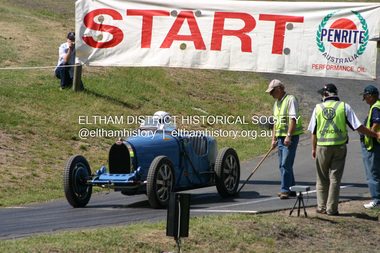
Photograph - Digital Photograph, Alan King, Rob Roy Hill Climb, 24 November 2007
... The club then established the Lakeland Hillclimb venue close to Lilydale.3 From 1979 to 1987 the MG Car Club ran hill climbs at the Templestowe Hillclimb until the land was to be sub-divided. In 1991 the MGCC approached the Shire of Nillumbik about using the derelict Rob Roy venue. ...The club then established the Lakeland Hillclimb venue close to Lilydale.3 From 1979 to 1987 the MG Car Club ran hill climbs at the Templestowe Hillclimb until the land was to be sub-divided. In 1991 the MGCC approached the Shire of Nillumbik about using the derelict Rob Roy venue. ...The Rob Roy Hill Climb originated in 1935 on the property of former Heidelberg Mayor, William Clinton, where he reared the Rob Roy breed of miniature ponies. He established Pleasure Grounds on part of the property attracting groups of Sunday visitors from Melbourne's inner suburbs. Visitors enjoyed a picnic area, pony rides, a dance hall and a tap room. Young men would ride their BSA or Harley Davidson motorcycles to the property which led to regular club-organised hillclimb meetings between 1930 and 1936. In 1935 Clinton offered the use of his property to the Light Car Club of Australia for their hillclimbs. The track was sealed that same year and the hillclimb at Clintons Road was one of only three specially designed bitumen surface hillclimbs in the world, the others being Shelsey Walsh and Prescott Hillclimbs in the UK. The first Light Car Club of Australia hillclimb was held at Rob Roy in February 1937. Covered under Heritage Overlay, Nillumbik Planning Scheme. Published: Nillumbik Now and Then / Marguerite Marshall 2008; photographs Alan King with Marguerite Marshall.; p133 About six times a year the unlikely sound of car engines emerges from deep in the heart of Christmas Hills.* Usually a quiet retreat, the Hills are home to one of the world’s oldest purpose-built motor sport venues - the Rob Roy Hillclimb. When sealed in 1939, the hillclimb at Clintons Road was one of only three specially designed bitumen surface hillclimbs in the world, the others being Shelsley Walsh and Prescott Hillclimbs in the UK.1 The Rob Roy Hillclimb originated in 1935 on the property of former Heidelberg mayor, William Clinton, where he reared the Rob Roy breed of miniature ponies. Rob Roy was the Scottish folk hero and outlaw. On part of his property Clinton established Pleasure Grounds, attracting Sunday parties from Melbourne’s inner suburbs. Visitors enjoyed a picnic area, pony rides, a dance hall and a tap room.2 Young men riding on their BSA or Harley Davidson bikes led to club-organised regular hillclimb meetings, between 1930 and 1936. In 1935 Clinton offered his property to the Light Car Club of Australia for their hillclimbs. In February 1937, the first Light Car Club of Australia hillclimb meeting was held at Rob Roy. Jack Day achieved the fastest time that day for the 760 yard (695m) track at 36 seconds in a Ford V8 engined Bugatti Special. At first the climb was just a dusty gravel track, but in 1939 it was up-graded and bituminised. Today the 695 metre track begins on a slight incline, proceeds through a sharp right turn, which formerly passed a rusty iron shed, now remembered by the name Tin Shed Corner. The track continues down a slight incline to a level stretch along the top of an embankment holding back a half-acre (0.2ha) dam, then up to a one-in-three gradient. The track then winds uphill through several left turns to the finish line. In 1939 Frank Kleinig reduced the record to 29.72 seconds in an MG Hudson. Throughout World War Two the Rob Roy Hillclimbs were suspended, but were resumed in 1947. The hillclimbs consistently attracted crowds averaging 500 to 600 people, peaking at 2000, until the hillclimb was destroyed by the 1962 bushfires. The meetings included nine Australian Hillclimb Championships, with the first in 1938 won by Peter Whitehead in his ERA. Eight of the Outright and Class record holders were Australian Grand Prix winners including Jack Brabham, who became a triple F1 World Champion. The Light Car Club of Australia held 61 meetings at Rob Roy. Events usually included Touring, Gran Turismo, Production, Sports, Racing and Vintage cars and in the latter years Go-carts. These meets suddenly stopped after the 1962 bushfire destroyed the access bridge on the property leading to the track area, although fortunately Clinton saved his home. The club then established the Lakeland Hillclimb venue close to Lilydale.3 From 1979 to 1987 the MG Car Club ran hill climbs at the Templestowe Hillclimb until the land was to be sub-divided. In 1991 the MGCC approached the Shire of Nillumbik about using the derelict Rob Roy venue. In 1992, after much lobbying, the club signed a ten-year lease from Melbourne Water, which has been renewed. The original track was faithfully reconstructed. Access roads were improved and guard rails were installed on the causeway. Permanent structures were rebuilt and tonnes of rubbish removed. This was made possible by an immense amount of voluntary work by MGCC members and financial support from the newly formed Friends of Rob Roy. In February 1993 the first Return to Rob Roy Historic Meeting was run with a huge spectator attendance of around 1000 enthusiasts. In September 2007, the Nillumbik Shire Council gave the hillclimb heritage protection. This acknowledged the property’s significant contribution to early Australian motor sport with its social connection to William Clinton and the local community.4 *Christmas Hills was named after emancipated convict and shepherd David Christmas, lost in these hills.This collection of almost 130 photos about places and people within the Shire of Nillumbik, an urban and rural municipality in Melbourne's north, contributes to an understanding of the history of the Shire. Published in 2008 immediately prior to the Black Saturday bushfires of February 7, 2009, it documents sites that were impacted, and in some cases destroyed by the fires. It includes photographs taken especially for the publication, creating a unique time capsule representing the Shire in the early 21st century. It remains the most recent comprehenesive publication devoted to the Shire's history connecting local residents to the past. nillumbik now and then (marshall-king) collection, rob roy hill climb, clintons road, light car club of australia, william clinton -
 Falls Creek Historical Society
Document - Orest Frueauf Letter - Support as Representative Of Commercial Interests On Committee Of Management
... He was successful in negotiating an indenture for land from the State Electricity Commission (SEC). ...Bob (Herman) Hymans (a former member of the Royal Netherlands Navy) was born in Bloemendaal, Holland on 30th September 1922. During World War II he fought against the Japanese in the Dutch East Indies (now Indonesia) and was imprisoned in Changi and on the Burma Railway. After gaining qualifications as a Ski Instructor, Bob arrived in Falls Creek in July 1950. Working as an Instructor and Supervisor at Bogong Lodge, Bob decided his future was in accommodation. He was successful in negotiating an indenture for land from the State Electricity Commission (SEC). It took Bob two years to build his Grand Coeur Chalet but, tragically, it was burned down in August 1961. Bob also built the first Chairlift in Australia. This was a single chairlift and the structure was built from wooden electricity poles. He was constantly full of new ideas and proposals for the village. Bob Hymans died on 7th July 2007. This Collection of documents and letters tells the story of Bob's endeavours to develop Falls Creek into the ski village it is today.This item is significant because it documents actions taken by the Falls Creek Tourist Area Management Committee in their role overseeing the Tourist Area.Letter from Orest Frueauf to Bob Hymans regarding the upcoming Management Committee election. He requested Bob's support in Orest's quest to be elected as the representative for those with commercial interests in Falls Creek. Orest raised concerns related to the release of further subdivisions in the Village which would double its size and put pressure on sewerage, water supply and roads. Other ongoing issues he referred to included oversnow transport, new tows, fire protection, finance, internal roads, search and rescue, publicity and booking arrangements. Orest believed that those with commercial interests needed to have a common approach and reliable representation on the Management Committee.falls creek tourist area management committee, falls creek administration, bob hymans -
 National Vietnam Veterans Museum (NVVM)
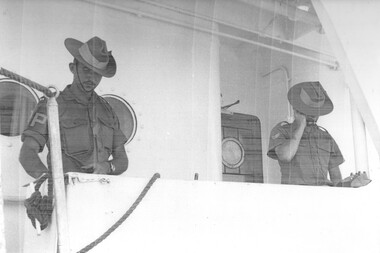
Photograph, Gibbons, Denis, Naval Supply Vessel Security
... A black and white photograph - One of the many duties carried out by the Australian Military Police at Vung Tau was the security and protection of the two Australian Naval Supply vessels, The MV Boonaroo & MV Jeparit, whilst on this duty the MP's had to look out for attack from water and land....Photograph Vung Tau Military Police Supply ship HMAS Boonaroo HMAS Jeparit Gibbons Collection Catalogue Australian Naval Supply Vessels MP's Denis Gibbons A black and white photograph - One of the many duties carried out by the Australian Military Police at Vung Tau was the security and protection of the two Australian Naval Supply vessels, The MV Boonaroo & MV Jeparit, whilst on this duty the MP's had to look out for attack from water and land. ...Denis Gibbons (1937 – 2011) Trained with the Australian Army, before travelling to Vietnam in January 1966, Denis stayed with the 1st Australian Task Force in Nui Dat working as a photographer. For almost five years Gibbons toured with nine Australian infantry battalions, posting compelling war images from within many combat zones before being flown out in late November 1970 after sustaining injuries. The images held within the National Vietnam Veterans Museum make up the Gibbons Collection. A black and white photograph - One of the many duties carried out by the Australian Military Police at Vung Tau was the security and protection of the two Australian Naval Supply vessels, The MV Boonaroo & MV Jeparit, whilst on this duty the MP's had to look out for attack from water and land.photograph, vung tau, military police, supply ship, hmas boonaroo, hmas jeparit, gibbons collection catalogue, australian naval supply vessels, mp's, denis gibbons -
 Wodonga & District Historical Society Inc
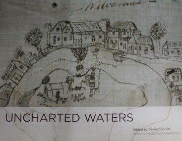
Book - Uncharted Waters, Daniel Connell, 2002
... Wodonga & District Historical Society Inc Hut 97, Bonegilla Migrant Experience, 132 Bonegilla Road Bonegilla the-murray murray-darling basin watershed management environmental protection Looks at the future of the Murray-Darling Basin and the livelihood of a large section of rural Australia, which is threatened because of unexpected consequences of water use and land clearing. ...Looks at the future of the Murray-Darling Basin and the livelihood of a large section of rural Australia, which is threatened because of unexpected consequences of water use and land clearing. The aim of this book is to stimulate public discussion and to present a wide range of views. Issued for the centenary of the Murray-Darling Basin Commission.non-fictionLooks at the future of the Murray-Darling Basin and the livelihood of a large section of rural Australia, which is threatened because of unexpected consequences of water use and land clearing. The aim of this book is to stimulate public discussion and to present a wide range of views. Issued for the centenary of the Murray-Darling Basin Commission.murray-darling basin, watershed management, environmental protection -
 Wodonga & District Historical Society Inc
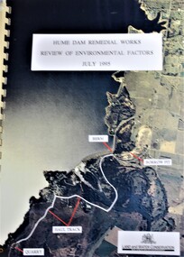
Booklet - Hume Dam Remedial Works - Review of Environmental Factors July 1995, Department of Land and Water Conservation, NSW Government, July 1995
... The work included foundation improvements to enhance earthquake protection and the enlargement and strengthening of the downstream embankment. hume dam remedial works dams environmental impact of dams The findings of a review into the environmental impact of remedial works being carried out on the Hume Dam. Hume Dam Remedial Works - Review of Environmental Factors July 1995 Booklet Hume Dam Remedial Works - Review of Environmental Factors July 1995 Department of Land and Water Conservation, NSW Government ...The findings of a review into the environmental impact of remedial works being carried out on the Hume Dam.non-fictionThe findings of a review into the environmental impact of remedial works being carried out on the Hume Dam.hume dam, remedial works dams, environmental impact of dams -
 Ballarat Heritage Services
Photograph - Photograph - Colour, Hepburn Springs Reserv, 2025, 12/12/2020
... Ballarat Heritage Services PO Box 2209 Bakery Hill Post Office goldfields The Hepburn Mineral Springs Reserve is approximately 30 hectares of public land adjacent to Hepburn Springs township that includes the Hepburn Mineral Springs bathhouse. ...The Hepburn Mineral Springs Reserve is approximately 30 hectares of public land adjacent to Hepburn Springs township that includes the Hepburn Mineral Springs bathhouse. The reserve, which contains a series of mineral springs that have been in continuous public use for drinking and bathing since the mid-19th century, are the best known of the large concentration of more than 100 mineral springs in Victoria's Central Highlands first systematically inventoried by the Geological Survey of Victoria in 1910 under Director of E.J. Dunn (1904 - 1912). A reserve of 0.5 hectares was first created on the site in 1868 to protect the springs from surrounding gold mining activities. The extent of the reserve was increased to its present size in the early 20th century as a result of local pressure for protection of the mineral springs local pressure and on the recommendation of Dunn that a network of Mineral Springs Reserves of standard size be established throughout Victoria.Colour photograph of Hepburn Springs Reserve and the encroaching weeds (broom, vinca, blackberry. .hepburn springs, locarno, mineral water, hepburn springs reserve, locarno spring, edna walling, hepburn springs pavilion