Showing 12 items matching "land degradation"
-
 Wodonga & District Historical Society Inc
Book - Agriculture and Conservation - Achieving a Balance, Australian Institute of Agricultural Science, September 1984
... ...land degradation...Wodonga & District Historical Society Inc Hut 97, Bonegilla Migrant Experience, 132 Bonegilla Road Bonegilla the-murray agriculture conservation land degradation This publication documents the proceedings of a conference held at Clyde Cameron College, Nordsvan Drive, Wodonga, Victoria on the 10th and 11th September, 1984. ...This publication documents the proceedings of a conference held at Clyde Cameron College, Nordsvan Drive, Wodonga, Victoria on the 10th and 11th September, 1984. It includes maps, diagrams and bibliographical references. Some of the topics included in the keynote addresses are:- soil degradation, the use of chemicals in agriculture, agriculture and the use of public land, prime agricultural land, management of native plants and animals on farms, water resource management, economics of conservation and rights and responsibilities of individuals in the use of freehold land.non-fictionThis publication documents the proceedings of a conference held at Clyde Cameron College, Nordsvan Drive, Wodonga, Victoria on the 10th and 11th September, 1984. It includes maps, diagrams and bibliographical references. Some of the topics included in the keynote addresses are:- soil degradation, the use of chemicals in agriculture, agriculture and the use of public land, prime agricultural land, management of native plants and animals on farms, water resource management, economics of conservation and rights and responsibilities of individuals in the use of freehold land.agriculture, conservation, land degradation -
 Tatura Irrigation & Wartime Camps Museum
Book, Emergence of Bioregionalism in the MD Basin, 1993
... An exploratory essay on he ongoing history of Murray Darling Basin includes legacies, explorations, soil erosion, irrigation divsity, land degradation, change, regionalism, conservation, maps of Vic. ...Tatura Irrigation & Wartime Camps Museum 49 Hogan Street Tatura the-murray An exploratory essay on he ongoing history of Murray Darling Basin includes legacies, explorations, soil erosion, irrigation divsity, land degradation, change, regionalism, conservation, maps of Vic. ...An exploratory essay on he ongoing history of Murray Darling Basin includes legacies, explorations, soil erosion, irrigation divsity, land degradation, change, regionalism, conservation, maps of Vic. NSW and QueenslandGloosy cover, brown marbled scenes from Berri Irrigation Area Reiver Murray, South Australia on back. Maps, water scenes, Pyap Estates on front.murray darling basin, legacies, erosion, degradation, diversity, tatura, murray river, books, rural, industry -
 Bendigo Historical Society Inc.
Newspaper - Kangaroo Flat Gold Mine Collection:, Department of Conservation and Environment, May 25/26 2002
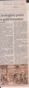
... Victoria will be sliced in half during the next two years by earth scientists who expect to reveal hidden mineral wealth and better understand land degradation caused by salinity. By using instruments that send vibrations into the earth, geologists will peel back the surface layers to expose a hidden landscape of buried hills, valleys and fossil streams, undiscovered gold and mineral wealth, and giant extinct volcanos. ...Victoria will be sliced in half during the next two years by earth scientists who expect to reveal hidden mineral wealth and better understand land degradation caused by salinity. By using instruments that send vibrations into the earth, geologists will peel back the surface layers to expose a hidden landscape of buried hills, valleys and fossil streams, undiscovered gold and mineral wealth, and giant extinct volcanos. ...Victoria will be sliced in half during the next two years by earth scientists who expect to reveal hidden mineral wealth and better understand land degradation caused by salinity. By using instruments that send vibrations into the earth, geologists will peel back the surface layers to expose a hidden landscape of buried hills, valleys and fossil streams, undiscovered gold and mineral wealth, and giant extinct volcanos. The $3 million project, called the Victorian Geotraverse, will attempt to expose the processes that shaped the state and helped form its mineral wealth. The project will be discussed at a conference, Victoria Undercover, in Benalla this week. Project leader Neil Phillips, chief of CSIRO Exploration and Mining, said the project would attempt to discover where the rest of Victoria's gold deposits might be found and where the next salinity disaster might strike. Using this process they will cut a 500-kilometre swathe through the Grampians, Bendigo, Benalla and Wodonga, curving down to Mallacoota on the far east coast. The project will involve 12 earth science agencies including the Victorian Department of Natural Resources and Environment, Geoscience Australia, the Cooperative Research Centre for Landscape, Environments and Mineral Exploration and the CSIRO. ('Age' newspaper, 28th April, 2002. https://www.theage.com.au/national/going-to-ground-for-state-secrets-20020428-gdu5tz.html Scientists will send shocks through the Victorian earth which will be reflected back and recorded on instruments that will reveal the density of the rocks below.'Australian' newspaper article, 25/26th May, 2002, 'Geologists point to gold bonanza'. Article describes the $5 million Geotraverse research in Victoria, undertaken by CSIRO geologists, that 'estimate the northern plains of Victoria conceal up to 5000 tonnes of gold'. Image on bottom of article, possibly S.T. Gill watercolour, titled 'Victorian miners pan for gold in the mid-1800's'.bendigo mining n.l., bendigo, mining, gold, csiro, geologist, geology, victorian geotraverse project -
 Eltham District Historical Society Inc
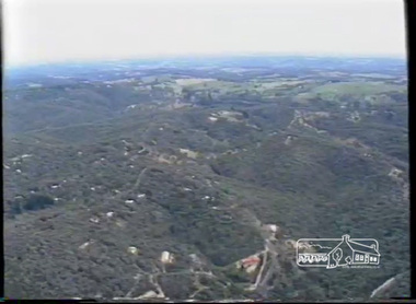
Film - Video (VHS), Phil Burke et al, Shire of Eltham Grants Commsission Submission (Series 69, Item 7), 1993
... Director of Planning & Environment, Richard Allen advises there are approximately 1,300 planning permits and development applications each year ranging from simple subdivision, boundary realignments to further complicated non-urban developments for agricultural pursuits and the level of expertise required from architectural and engineering to land degradation, flora and fauna. Video finishes with aerial views and parklands, streetscapes and rural areas. ...Director of Planning & Environment, Richard Allen advises there are approximately 1,300 planning permits and development applications each year ranging from simple subdivision, boundary realignments to further complicated non-urban developments for agricultural pursuits and the level of expertise required from architectural and engineering to land degradation, flora and fauna. Video finishes with aerial views and parklands, streetscapes and rural areas. shire of eltham video recording shire of eltham archives eltham shire council eltham building permits cricket ground development applications eltham copper butterfly garbage collection graders green wedge lower plenty meals on wheels montmorency pat vaughan pauline toner reserve planning applications planning permits ranger services recreational facilities research richard allen roads rural areas wingrove park Victoria Grants Commission VHS Video cassette Converted to MP4 file format 00:07:39; 89MB Shire of Eltham Grants Commsission Submission (Series 69, Item 7) Film Video (VHS) Phil Burke Stuart Miller Roslyn Cohen Peter Mumme Gary Bartlett ...Shire of Eltham Archives: Series 69, Item 7 Opens with aerial views of the Shire, 85% of the shire covered by the Green wedge principal. Discusses the obligations required of the Shire to maintain the Green Wedge. The Shire covers over 27,000 hectares with a population in excess of 45,000 residents, more than 70% living in the southern 10% of the Shire in suburbs of Eltham, Montmorency, Lower Plenty and Research. 85% of the Shire in the more sparsely populated northern area which is covered by the Green Wedge. Council is committed to providing a parity of services to all residents such as garbage collection and maintenance of roads. Views of rubbish collection trucks in Montmorency. It is emphasised that the cost of these services in highly populated areas is relatively low whereas in the sparsely populated Green Wedge areas, considerable. There are hundreds of kilometres of roads throughout the Shire, many unmade and maintenance is high to check overhanging trees and erosion especially on the steep hills is expensive and disproportionate to servicing the population in the dense urban areas. Shows views of hilly gravel roads and graders at work maintaining them. Shows scenes of assessing planning applications in these rural areas which takes significantly more time as well as other services provided such as Meals on Wheels, building permits, Ranger services. Provision of recreational facilities in hilly areas requires the acquisition of expensive river flats (views of cricket ground surrounded by hills) and where not possible, costly earthmoving required. Also, views highlighting extensive tracks of natural habitat home to significant bird, animal and plant life. Shire emphasises its commitment highlighted by the Eltham Copper Butterfly which the Shire maintains small pockets of bushland to ensure its survival at significant expense (views of Pauline Toner Copper Butterfly Reserve.) Short interview with Pat Vaughan, Environmental Officer for the Shire discussing the Eltham Copper Butterfly who also mentions many other species in the Shire of high significance from bats to mammals to plants as well as the importance of the Green Wedge to Melbourne – the lungs of Melbourne - and ensuring the protection of very important habitat which requires a great deal of planning and management to look after. Views of Wingrove Park to emphasise this maintenance by machinery in some areas is too damaging and introduced species, etc must be removed by hand. Balancing the services and facilities expected by the community with the needs of the environment requires careful planning demands requires careful planning and the principals of the Green Wedge require constant attention in the face of growing need for housing. Director of Planning & Environment, Richard Allen advises there are approximately 1,300 planning permits and development applications each year ranging from simple subdivision, boundary realignments to further complicated non-urban developments for agricultural pursuits and the level of expertise required from architectural and engineering to land degradation, flora and fauna. Video finishes with aerial views and parklands, streetscapes and rural areas. VHS Video cassette Converted to MP4 file format 00:07:39; 89MBshire of eltham, video recording, shire of eltham archives, eltham shire council, eltham, building permits, cricket ground, development applications, eltham copper butterfly, garbage collection, graders, green wedge, lower plenty, meals on wheels, montmorency, pat vaughan, pauline toner reserve, planning applications, planning permits, ranger services, recreational facilities, research, richard allen, roads, rural areas, wingrove park, victoria grants commission -
 Eltham District Historical Society Inc
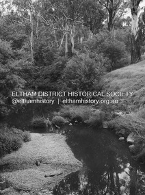
Photograph - Digital Photograph, Alan King, Kinglake National Park, 27 March 2008
... Thanks to the vision and hard work of a band of local people, the park was created from what was rapidly becoming degraded land. Seeing a threat to Kinglake’s indigenous flora and fauna, several prominent local people campaigned for a national park, which was established in 1928.1 Since then, the park has grown through donations and acquisitions of land, from around 13,800 acres of land (5585ha) to 22,360 hectares. ...Thanks to the vision and hard work of a band of local people, the park was created from what was rapidly becoming degraded land. Seeing a threat to Kinglake’s indigenous flora and fauna, several prominent local people campaigned for a national park, which was established in 1928.1 Since then, the park has grown through donations and acquisitions of land, from around 13,800 acres of land (5585ha) to 22,360 hectares. ...Fern gullies around Jehosaphat Gully Covered under National Estate. Published: Nillumbik Now and Then / Marguerite Marshall 2008; photographs Alan King with Marguerite Marshall.; p125 The magnificent Kinglake National Park, fringing Nillumbik’s north, is the largest national park close to Melbourne. Thanks to the vision and hard work of a band of local people, the park was created from what was rapidly becoming degraded land. Seeing a threat to Kinglake’s indigenous flora and fauna, several prominent local people campaigned for a national park, which was established in 1928.1 Since then, the park has grown through donations and acquisitions of land, from around 13,800 acres of land (5585ha) to 22,360 hectares. The Sugarloaf and Everard Blocks – of almost 8000 hectares – stand in Nillumbik and the park extends into Mitchell and Murrundindi Shires and the City of Whittlesea. Mt Everard commemorates William Hugh Everard, State member for Evelyn when the park was established. Before 1928, European settlers had degraded the Kinglake area, which was named after the celebrated English author and lawyer, Alexander William Kinglake. Remains of gold shafts and diggings in the park are reminders of Kinglake’s first settlers, who hoped to strike it rich at the gold diggings. But like other gold fields in this shire, they proved not very lucrative and soon timber cutting replaced mining in importance. However, before long, the accessible timber supply ran out, so in the 1920s agriculture took over – particularly potatoes and berry fruits – which involved large-scale clearing.2 The park’s instigator was retired Melbourne University Professor of Music, William Laver.3 As chair of the Kinglake Progress Association he began negotiations to have crown lands on the southern scarp of the Great Dividing Range reserved as a national park. Even before the park was proclaimed, from 1927, KPA members cut tracks to the major scenic points. Professor Laver was one of several people who gave land for the park, donating around 50 acres (20ha), including the Jehosaphat Gully.4 Laver chaired the park’s first Committee of Management, which raised money to employ a ranger and provide facilities, including tracks and roads for fire protection vehicles, toilets and shelters. The committee charged fees for firewood collection, some grazing of livestock, and visitor entrance, and obtained small State Government and Eltham Shire grants. In 1957 the State Government provided revenue for national parks. Then, in 1975, the State Government took over the management and the Committee of Management became an advisory committee, which disbanded in 1978. Originally, the park covered crown land in the Shires of Eltham and Whittlesea; then Wombelano Falls in Yea and other areas were added. In 1970 the park extended into the Shires of Eltham, Healesville, Whittlesea and Yea.5 Bush fires have been an ongoing problem. In 1939 hundreds of eucalypts and acacias had to be sown around the Jehosaphat Gully to rejuvenate the forest. To manage bushfires, the Committee of Management, then the State Government, worked closely with the Forestry Commission, shire councils and local fire brigades. Early national parks focussed on recreation. But by the 1980s, conservation, education and scientific research became more important, playing a vital role in preserving representative samples of the natural environment. Each year many thousands of people use the park’s extensive network of walking tracks amongst the protected plant and animal life as well as camping, cycling and horse riding. The park, along the slopes of the Great Dividing Range, has lookouts revealing magnificent views of the Melbourne skyline, Port Phillip Bay, the Yarra Valley and the You Yangs. Vegetation in the Masons Falls area includes messmate forest, Austral grass-trees, ferns and Hazel Pomaderris. In spring, orchids, lilies, everlasting daisies, correas, grevillea and heath appear. Around Jehosaphat Gully are wet and dry forest, fern gullies and banksia. Animal life includes wallabies, kangaroos, koalas, echidnas, possums, gliders and bandicoots. Male lyrebirds can be heard mimicking in the Jehosaphat Gully, particularly in the Everard Block in winter.This collection of almost 130 photos about places and people within the Shire of Nillumbik, an urban and rural municipality in Melbourne's north, contributes to an understanding of the history of the Shire. Published in 2008 immediately prior to the Black Saturday bushfires of February 7, 2009, it documents sites that were impacted, and in some cases destroyed by the fires. It includes photographs taken especially for the publication, creating a unique time capsule representing the Shire in the early 21st century. It remains the most recent comprehenesive publication devoted to the Shire's history connecting local residents to the past. nillumbik now and then (marshall-king) collection, kinglake national park, jehosaphat gully -
 Eltham District Historical Society Inc
Photograph - Digital Photograph, Alan King, Diamond Creek, Barak Bushlands, Eltham, 2008
... degraded flood plain into this refuge of natural beauty. In 1997, shortly after moving into the new Riverside Estate on Falkiner Street, Eltham, several residents noticed the sorry state of the Diamond Creek and surrounding area. Part of it was used as a cow paddock and although small patches of vegetation survived, the area was infested with weeds, rabbits, rubbish and drainage from the housing estate. At various times the 4.4 hectares had been used as a market garden and for shire stock piles. The residents began to restore the area by revegetating land...degraded flood plain into this refuge of natural beauty. In 1997, shortly after moving into the new Riverside Estate on Falkiner Street, Eltham, several residents noticed the sorry state of the Diamond Creek and surrounding area. Part of it was used as a cow paddock and although small patches of vegetation survived, the area was infested with weeds, rabbits, rubbish and drainage from the housing estate. At various times the 4.4 hectares had been used as a market garden and for shire stock piles. The residents began to restore the area by revegetating land ...A habitat corridor and it strengthens the community. Published: Nillumbik Now and Then / Marguerite Marshall 2008; photographs Alan King with Marguerite Marshall.; p185 Barak Bushlands lie west of the Diamond Creek on the corner of Falkiner Street and busy, noisy Main Road. They form part of an important habitat corridor linking the Yarra River to the Kinglake National Park.1 Manna Gums, tawny frogmouths and platypuses are some of the indigenous plants and animals that have made their home there. The bushlands are the result of more than nine years of hard work by the local community with the Nillumbik Council, to transform a degraded flood plain into this refuge of natural beauty. In 1997, shortly after moving into the new Riverside Estate on Falkiner Street, Eltham, several residents noticed the sorry state of the Diamond Creek and surrounding area. Part of it was used as a cow paddock and although small patches of vegetation survived, the area was infested with weeds, rabbits, rubbish and drainage from the housing estate. At various times the 4.4 hectares had been used as a market garden and for shire stock piles. The residents began to restore the area by revegetating land along the Diamond Creek. In 1998 they established the Friends of the Diamond Creek Falkiner Street Reserve2 and 35 families joined from the 90-house Estate. Carolyn Mellor, as the Friends’ Land Manager, undertook a four-year horticulture course to guide this massive project for a volunteer organisation. Since 1999, she has been the Friends’ President. In 1999 the Friends urged the Nillumbik Council to undertake a feasibility study into establishing a wetland system and urban forest. Work began in 2002 with Nillumbik Council funding the project, supplemented by government grants. The Friends also received grants from Melbourne Water and Parks Victoria. Aided by the Friends and other community members, the Council created the Barak Bushlands consisting of a forest, a wetland, a bridge, a path and open space. The beautiful wetland treats most of the estate’s stormwater runoff. Storm water is filtered through plants in the wetland ponds then is released slowly into the billabong, before flowing into the Diamond Creek. The wetland also helps to minimise flooding and the improved water quality provides a flora and fauna habitat. The Friends and other volunteers planted more than 27,000 plants, more than one third of which they grew from seeds they collected at Lower Eltham and Wingrove Parks. Eltham High School students planted thousands of these through a Year Eight program introduced for this purpose. Other groups who assisted were: Green Corps, local Scouts and Guides – 2nd Montmorency, 1st Diamond Creek and 1st Eltham Cub Packs, Eltham College students, Eltham East Primary School, Landcare members, Eltham Lions Club and the Eltham Baptist Church. To maintain enthusiasm for the mammoth task, the Friends and other volunteers ‘adopted’ trees to water and wrote their names on the stakes. In 2004, to recognise the area’s original occupiers, the reserve was named Barak Bushlands. William Barak, who lived from 1824 to 1903, was the last chief of the Yarra Yarra tribe of the Wurundjeri-willam people. Traces of these original inhabitants remain in scar trees (bark sections removed to make a shield or canoe). That same year the Friends’ group was a finalist in the prestigious Federal Government, Banksia Environmental Awards. The Friends have also participated in Clean Up Australia, removing tonnes of rubbish and regularly testing the billabong, wetland and creek, for pollutants. For years the Friends, together with the Australian Platypus Conservancy, have tagged, measured and checked the health of platypuses from the Diamond and Mullum Mullum Creeks. With Latrobe University the Friends have conducted night walks to view owls, possums, bats and sugar gliders. Challenges for the council and the Friends continue with a large rabbit population, some vandalism, weed eradication and maintenance. However, thanks to this community effort, locals can now escape confined urban living on small blocks of land and enjoy the beauty of indigenous plants and animals. Working together has also strengthened the local community,This collection of almost 130 photos about places and people within the Shire of Nillumbik, an urban and rural municipality in Melbourne's north, contributes to an understanding of the history of the Shire. Published in 2008 immediately prior to the Black Saturday bushfires of February 7, 2009, it documents sites that were impacted, and in some cases destroyed by the fires. It includes photographs taken especially for the publication, creating a unique time capsule representing the Shire in the early 21st century. It remains the most recent comprehenesive publication devoted to the Shire's history connecting local residents to the past. nillumbik now and then (marshall-king) collection, barak bushlands, diamond creek (creek), eltham -
 Bendigo Historical Society Inc.
Document - LANDS OFFICE: SANDHURST LISTS OF ALLOTMENTS SOLD 1854 - 1856, 1854 - 1856
... Sandhurst land sales outlying districts 1854 -1861. Loose pages in plastic pockets, blue lined, formerly in register that has degraded and not repairable. ...land sales outlying districts 1854 -1861. Loose pages in plastic pockets, blue lined, formerly in register that has degraded and not repairable. ...Document: LANDS OFFICE: SANDHURST LISTS OF ALLOTMENTS SOLD 1854 - 1856 Sandhurst lists of allotments sold, dated 1854 - 1856. Sandhurst land sales outlying districts 1854 -1861. Loose pages in plastic pockets, blue lined, formerly in register that has degraded and not repairable. Lists of date of sale, no. of lot, parish, allotment, section, extent (size) purchasers name.Lands Officeland sales 1854, lands office, sandhurst, bendigo -
 Bendigo Historical Society Inc.
Document - LANDS OFFICE, INDEX OF CORRESPONDENCE INWARDS 1861 ONWARDS, 1861
... History House 11 Mackenzie Street Bendigo goldfields ORGANISATION Government Lands Office land sales Bendigo Sandhurst Lands Office Journal: buff coloured hard cover journal with ruled pages containing details of inward correspondence. Spine is badly degraded ...Journal: buff coloured hard cover journal with ruled pages containing details of inward correspondence. Spine is badly degraded and frayed. On front cover '10' written in black pen. White sticker with '07A' on front. Index of letter A-Z in front. Section after index has columns: local office No., date received, name, subject, instructions, how disposed of, on numbered pages. Loose pages inserted - more indexes, Mallee parishes in Bendigo Lands District.Lands Officeorganisation, government, lands office, land sales, bendigo, sandhurst -
 National Wool Museum
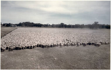
Photograph, Puckapunyal - 75,172 Sheep for Shearing, 1988
... In the 1980s the Army undertook a major 60,000-acre land rehabilitation programme as decades of heavy use had led to serious degradation. ...In the 1980s the Army undertook a major 60,000-acre land rehabilitation programme as decades of heavy use had led to serious degradation. ...Banjo Paterson once wrote, ‘The musterers are fetching them a hundred thousand strong’. Well, not quite 100,000 strong, but there are 75,172 mixed age Riverina-bred merino wethers in this mob mustered for shearing on January 22, 1988. The sheep were owned by the Mountjoy family from Geelong Victoria and were running on Puckapunyal Army Base near Seymour in Central Victoria on which the family held the grazing lease. Contractor for the shearing, Jim Walker, Avenel, Victoria, former Australian shearing team captain in 1974-75 and 1978-79, recalls there were up to 21 shearers in his team waiting for the red eyes to arrive despite the mid-summer heat of up to 38°C and the blinding dust on windy days. Jim Walker thinks there may also have been some sheep in the mob from Portland Downs and Isis Downs near Isisford in Central Queensland. The biggest shearing he did at ‘Pucka’ was 87,087 shorn in 1988. The ‘Pucka’ base was established during WW1. During the Second World War the Second Australian Imperial Force trained there as well as the US Army 41st Infantry Division. It was also home to the 1st Armoured Regiment from 1949 until 1995. During the 1950s up to 4000 national servicemen at any given time were training there. In the 1980s the Army undertook a major 60,000-acre land rehabilitation programme as decades of heavy use had led to serious degradation. By 1988 when the photo was taken, further land acquisition had increased the area to just under 100,000 acres, 43,000 of which is still bush country. There are no sheep there now, and the old shed was bulldozed and burnt. There are thousands of kangaroos which of course don’t need to be shorn and would be hard to muster and hold for a similar photo. Colour photograph, 75,172 merino wethers, mustered for shearing at Puckapunyal in 1988.shearing merino sheep, mountjoy, mr dale - worungalla pastoral co., shearing, merino sheep -
 Surrey Hills Historical Society Collection
Digital photo, George Lister Coop with his sister Alison, c1950, c1950
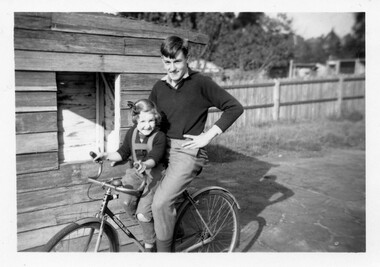
... degraded tennis court. He recalled that in his youth there were many private tennis courts in the area made possible by the generous size of the blocks of land. ...degraded tennis court. He recalled that in his youth there were many private tennis courts in the area made possible by the generous size of the blocks of land. ...The photo was taken at 688 Whitehorse Road, Mont Albert. It is of George Lister Coop (b1937) and his sister Alison (b1945). This was the home of 3 generations of the Coop family: 1. Josephine and George Frank Coop (noted in Box Hill Rate Books for 1947-1954). 2. George Burton Coop (1906-1960) and his family. He was Assistant Chief Architect of Victoria in the Public Works Department (P.W.D.) George Burton Coop was born in c1906 in Williamstown, the son of Josephine Vistarini and George Frank Coop. He married Winifred Alice Trewartha in 1936 and they are listed in the electoral rolls at 688 Whitehorse Road in 1937. George died 3/4/1960, aged 54 years at Mont Albert; Alice died in 1980. 3. George Burton and Alice Coop had 2 children: The donor George Lister Coop informed that the wooden shed was a cubby house built upon a degraded tennis court. He recalled that in his youth there were many private tennis courts in the area made possible by the generous size of the blocks of land. George initially attended Chatham State School because his first home was the Spanish Mission style flats at 346 Whitehorse Road, opposite Brenbeal Street, Balwyn. When his grandparents died, the family moved to 688 Whitehorse Road and he then attended Mont Albert Central School. Alison being younger did not go to Chatham Primary. A black & white photo of a teen-aged boy with a young girl on a bicycle in front of a timber shed on a degraded paved area. In the background is a paling fence with a strip of un-mown grass. Beyond the fence the outbuildings of the adjacent property can be seen. george lister coop, alison coop, bicycles, whitehorse road, surrey hills, children -
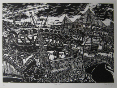 Federation University Art Collection
Work on paper - Printmaking - Relief Print, Starling, Anne, 'Innerwest' by Anne Starling, 2003
... She focuses on the neglect that has occurred due to misuse and exploitation by industrial manufacturers, and the social and ecological structures of areas surrounding of Rhodes in Sydney, Fremantle in Western Australia and Port Kembla in New South Wales.Through relief and drypoint prints she examine changes that occur in this environment, presenting a commentary on the degradation and pollution of land by industry and the surrounding urban landscape. ...She focuses on the neglect that has occurred due to misuse and exploitation by industrial manufacturers, and the social and ecological structures of areas surrounding of Rhodes in Sydney, Fremantle in Western Australia and Port Kembla in New South Wales.Through relief and drypoint prints she examine changes that occur in this environment, presenting a commentary on the degradation and pollution of land by industry and the surrounding urban landscape. ..."In my woodblock print I have focused on the architectrure, streetscape and layout of the city. I am itrigued with teh organisation of cities and in teh creation of my own image. In this work I have almalgamated site drawings of buildings, streets and various structures to create a fish eye viewof the inner west of Sydney. By creating such a cityscape I form an historical document and record of the specific place."Anne STARLING (1967 - ) Born Sydney, New South Wales A graduate of the City Art Institute/UNSW College of Fine Arts, Anne Starling completed a Master of Art in 1994 and Master of Fine Arts by Research in 2012. Human interaction with the urban and industrial landscape is central to the work of Anne Starling. She focuses on the neglect that has occurred due to misuse and exploitation by industrial manufacturers, and the social and ecological structures of areas surrounding of Rhodes in Sydney, Fremantle in Western Australia and Port Kembla in New South Wales.Through relief and drypoint prints she examine changes that occur in this environment, presenting a commentary on the degradation and pollution of land by industry and the surrounding urban landscape. This item is part of the Federation University Art Collection. The Art Collection features over 2000 works and was listed as a 'Ballarat Treasure' in 2007.Framed black and white relief print (woodblock) representing a collage of various Sydney architecture. art, artwork, anne starling, printmaking, woodblock, print council of australia, sydney, architecture, bridge, cityscape -
Koorie Heritage Trust
Book, Bonwick, James, The Last of the Tasmanians : or The Black War of Van Diemen's Land, 1870
... Degradation Theory; Effects of Civilization; Drink and Civilization; Walter the civilized Tasmanian; An Aboriginal Discourse; Mr. Wedge's Black Boy; Failure of Australian Missions; Christian Tasmanians. Decline - Amalgamation of Races; Decline, a 'Decreeof Providence'; Hawaiian and Maori Decline; Drink, the great Destroyer; Story of the civilised Mathinna; Count Strzelecki's Theory of Decline; Lanne, the Last Man; Lalla Rookh, the Last Tasmanian. 400 p., 15 leaves of ports. : ill., fold-out map ; 23 cm. The Last of the Tasmanians : or The Black War of Van Diemen's Land ...Contents: Voyagers' Tales of the Tasmanians - The first battle; Captain Cook's visit; The French visit in 1792; Flinders and Bass at the Derwent; Peron's visit in 1802; The French and the Wood-nymphs. The Black War - Massacre of the Blacks in 1804; Destruction of Public Records; Kidnapping Black Boys; Michael Howe's Black Mary; Chase after Stock-keepers; Colonel Sorell's order of 1819. Cruelties to the Blacks - Cruelty of Early Settlers; Cruelty of Bushrangers; Spanish and Dutch Cruelties. Outrages of the Blacks - Hanging of Two Aborigines; The Demarcation Order of 1828; Martial Law; Pictorial Proclamation; Proclamation of October 1830; Mosquito and the Tame Mob; Execution of Mosquito and Black Jack; Cruelties of the Blacks; A hand left in the trap; Bravery of a Half-caste wife; Chastity of White Women respected; Time of terror. The Line - Proclamation for Volunteers; Arrangements for the Capture; Leaders and numbers in the Line; Savage's Tale of the Savages; Mr. Walpole caught a Black; Siege of the "Three Thumbs"; Ï30,000 for One Black; Egg-gathers break through a Line. Capture Parties - Leaders of Parties; John Batman, the Blacks' Friend; The Sydney Black Guides; A Night at Ben Lomond; Gilbert Robertson, the Leader; Jorgen Jorgenson, the Dane. George Augustus Robinson, The Concilliator - Bruni Island Depot; Tuganina, the beautiful Tasmanian; The Conciliatory Mission; Robinson's Capture of a Tribe; Triumphal Entry into Hobart Town; Truganina saves Robinson's Life. Flinders Island - Swan Island Depot; Gun Carriage Island; Flinders Island Depot; Visit of the Quaker Missionaries; Life of Aborigines on Flinders Island; Mr Clark, the Catechist; School Examination of the Natives; Dr. Jeannert, the Commandant; Dr Milligan removes Natives from Flinders. Oyster Cove - Author's Visit to the Naives at Oyster Cove; Death of Mr Clark; Maryann and Walter. The Sealers - Home Life of Sealers' Women; Robinson removes the Women to Flinders; The Quakers and Sealers. Half-Castes - Murder of Half-castes; Fecundity of Mixed Races; Bishop Nixon's Visit to the Straits' Half-castes; Bong and her Daughter Dolly. Native Rights - Legal Rights; Hanging of Four Tasmanians. Civilization - Whately's Degradation Theory; Effects of Civilization; Drink and Civilization; Walter the civilized Tasmanian; An Aboriginal Discourse; Mr. Wedge's Black Boy; Failure of Australian Missions; Christian Tasmanians. Decline - Amalgamation of Races; Decline, a 'Decreeof Providence'; Hawaiian and Maori Decline; Drink, the great Destroyer; Story of the civilised Mathinna; Count Strzelecki's Theory of Decline; Lanne, the Last Man; Lalla Rookh, the Last Tasmanian.400 p., 15 leaves of ports. : ill., fold-out map ; 23 cm.Contents: Voyagers' Tales of the Tasmanians - The first battle; Captain Cook's visit; The French visit in 1792; Flinders and Bass at the Derwent; Peron's visit in 1802; The French and the Wood-nymphs. The Black War - Massacre of the Blacks in 1804; Destruction of Public Records; Kidnapping Black Boys; Michael Howe's Black Mary; Chase after Stock-keepers; Colonel Sorell's order of 1819. Cruelties to the Blacks - Cruelty of Early Settlers; Cruelty of Bushrangers; Spanish and Dutch Cruelties. Outrages of the Blacks - Hanging of Two Aborigines; The Demarcation Order of 1828; Martial Law; Pictorial Proclamation; Proclamation of October 1830; Mosquito and the Tame Mob; Execution of Mosquito and Black Jack; Cruelties of the Blacks; A hand left in the trap; Bravery of a Half-caste wife; Chastity of White Women respected; Time of terror. The Line - Proclamation for Volunteers; Arrangements for the Capture; Leaders and numbers in the Line; Savage's Tale of the Savages; Mr. Walpole caught a Black; Siege of the "Three Thumbs"; Ï30,000 for One Black; Egg-gathers break through a Line. Capture Parties - Leaders of Parties; John Batman, the Blacks' Friend; The Sydney Black Guides; A Night at Ben Lomond; Gilbert Robertson, the Leader; Jorgen Jorgenson, the Dane. George Augustus Robinson, The Concilliator - Bruni Island Depot; Tuganina, the beautiful Tasmanian; The Conciliatory Mission; Robinson's Capture of a Tribe; Triumphal Entry into Hobart Town; Truganina saves Robinson's Life. Flinders Island - Swan Island Depot; Gun Carriage Island; Flinders Island Depot; Visit of the Quaker Missionaries; Life of Aborigines on Flinders Island; Mr Clark, the Catechist; School Examination of the Natives; Dr. Jeannert, the Commandant; Dr Milligan removes Natives from Flinders. Oyster Cove - Author's Visit to the Naives at Oyster Cove; Death of Mr Clark; Maryann and Walter. The Sealers - Home Life of Sealers' Women; Robinson removes the Women to Flinders; The Quakers and Sealers. Half-Castes - Murder of Half-castes; Fecundity of Mixed Races; Bishop Nixon's Visit to the Straits' Half-castes; Bong and her Daughter Dolly. Native Rights - Legal Rights; Hanging of Four Tasmanians. Civilization - Whately's Degradation Theory; Effects of Civilization; Drink and Civilization; Walter the civilized Tasmanian; An Aboriginal Discourse; Mr. Wedge's Black Boy; Failure of Australian Missions; Christian Tasmanians. Decline - Amalgamation of Races; Decline, a 'Decreeof Providence'; Hawaiian and Maori Decline; Drink, the great Destroyer; Story of the civilised Mathinna; Count Strzelecki's Theory of Decline; Lanne, the Last Man; Lalla Rookh, the Last Tasmanian. aboriginal tasmanians. | tasmania -- history -- to 1803. | tasmania -- history -- 1803-1900.