Showing 7 items matching "land sales maddingley"
-
 Bacchus Marsh & District Historical Society
Map, Gaynor Street Land Sales, Maddingley, circa 1880s-1890s
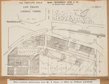
... Gaynor Street Land Sales, Maddingley, circa 1880s-1890s......Land Sales Maddingley...Gaynor Street Land Sales, Maddingley, circa 1880s-1890s Map Shire of Bacchus Marsh ...This map was produced for a major sale of land in the Maddingley area of Bacchus Marsh. The precise date of the sale has not been determined. Features present on the map such as the Bacchus Marsh Railway Station indicate the land sale must have taken place some time after 1887 when the Railway Station opened. A single page paper map showing land allotments for sale in the Maddingley area of Bacchus Marsh. Locations shown include Gaynor Street, Maddingley Road South, Parwan Road, Mitchem Street, Typpynge Street, Finn Street and East Maddingley Road. . The map is pasted into a bound volume containing 76 maps or plans in total. High resolution digital image stored on BMDHS computer network. bacchus marsh victoria maps, maddingley victoria maps, land use, maddingley victoria history, land sales bacchus marsh, land sales maddingley -
 Bacchus Marsh & District Historical Society
Map, Gaynor Street Area Land Sales, Maddingley, 1888
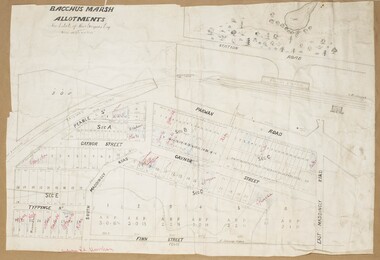
... Gaynor Street Area Land Sales, Maddingley, 1888.......Land Sales Maddingley...Gaynor Street Area Land Sales, Maddingley, 1888. Map Shire of Bacchus Marsh ...This map was produced for a major sale of land in the Maddingley area of Bacchus Marsh in 1888. The sale was conducted by two firms from Melbourne, Carney and Kelly 12 Swanston Street Melbourne. and 'Richardson, Kerr & Co. 40 Flinders Lane Melbourne. 136 blocks were for sale.A single page paper map showing land allotments for sale in the Maddingley area of Bacchus Marsh. Locations shown include Gaynor Street, Maddingley Road South, Parwan Road, Mitchem Street, Typpynge Street, Finn Street and East Maddingley Road. . The map is pasted into a bound volume containing 76 maps or plans in total. High resolution digital image stored on BMDHS computer network. bacchus marsh victoria maps, maddingley victoria maps, land use, maddingley victoria history, land sales bacchus marsh, land sales maddingley -
 Bacchus Marsh & District Historical Society
Map, Bacchus Marsh Suburban Allotments Parwan Road Lodge & Dunn's Paddocks 1888
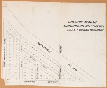
... Land Sales Bacchus Marsh...Land Sales Maddingley...Land Sales Bacchus Marsh Land Sales Maddingley Bacchus Marsh Victoria Maps Maddingley Victoria Maps A single page paper map showing allotments of land for sale along the Parwan Road in Maddingley. ...This map was created as a plan for an auction of land close to the Bacchus Marsh Railway Station. The auction took place on 23 October 1888. 102 allotments of land from an area known as Lodge and Dunn's paddocks was offered for sale. A single page paper map showing allotments of land for sale along the Parwan Road in Maddingley. The map is pasted into a bound volume containing 76 maps or plans in total. High resolution digital image stored on BMDHS computer network. land sales bacchus marsh, land sales maddingley, bacchus marsh victoria maps, maddingley victoria maps -
 Bacchus Marsh & District Historical Society
Map, Bacchus Marsh Tuesday 23rd Oct. 1888, Lodge & Dunn's Paddocks 1888. Business and Mansion Sites
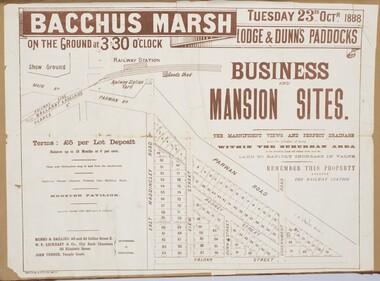
... Land Sales Bacchus Marsh...Land Sales Maddingley...Land Sales Bacchus Marsh Land Sales Maddingley Bacchus Marsh Victoria Maps Maddingley Victoria Maps At bottom on left side: 'Harston & Co. ...This map was created as a plan for an auction of land close to the Bacchus Marsh Railway Station. The auction took place on 23 October 1888. 102 allotments of land from an area known as Lodge and Dunn's paddocks was offered for sale. The auction was conducted by auctioneers based in Melbourne and was advertised in Melbourne newspapers as well as in the Bacchus Marsh Express newspaper. The auction plan contains a range of details including the selling agents, Munro and Baillieu; W.P. Lockhart; and John Turner, all of Melbourne, deposit terms for purchases, price of railway passes for a return trip from Melbourne to Bacchus Marsh of 1 shilling, and a description of the land as having 'magnificent views and perfect drainage'. A single page paper map showing allotments of land for sale along the Parwan Road in Maddingley. The map is pasted into a bound volume containing 76 maps or plans in total. High resolution digital image stored on BMDHS computer network. At bottom on left side: 'Harston & Co. Lith, Melb.'land sales bacchus marsh, land sales maddingley, bacchus marsh victoria maps, maddingley victoria maps -
 Bacchus Marsh & District Historical Society
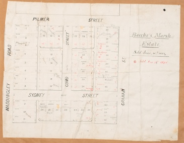
Map, Bacchus Marsh Estate sold 30th June 1888 and sold 28 December 1895
... Land Sales Bacchus Marsh...Pilmer Street Bacchus Marsh...Graham Street Bacchus Marsh...Sydney Street Bacchus Marsh...Como Street Bacchus Marsh...Maddingley...land in this area of Bacchus Marsh were sold in lots between 1888 and the late 1890s. This map shows sales made in 1888 and 1895. Bacchus Marsh Victoria Maps Land Sales Bacchus Marsh Pilmer Street Bacchus Marsh Graham Street Bacchus Marsh Sydney Street Bacchus Marsh Como Street Bacchus Marsh Maddingley Road Bacchus Marsh Grant Street Bacchus Marsh Single page map showing allotments of land bounded by Pilmer Street, Graham Street, Sydney Street and Maddingley Road (Grant Street) in Bacchus Marsh.The area is dissected by Como Street down the central area. 43 blocks of land are shown with the names of buyers or sellers in 1888 written in black in. ...Blocks of land in this area of Bacchus Marsh were sold in lots between 1888 and the late 1890s. This map shows sales made in 1888 and 1895.Single page map showing allotments of land bounded by Pilmer Street, Graham Street, Sydney Street and Maddingley Road (Grant Street) in Bacchus Marsh.The area is dissected by Como Street down the central area. 43 blocks of land are shown with the names of buyers or sellers in 1888 written in black in. Buyers or sellers for December 1895 are written in red ink. Part of a set of maps which are pasted into a bound volume containing 76 maps or plans in total. High resolution digital image stored on BMDHS computer network. bacchus marsh victoria maps, land sales bacchus marsh, pilmer street bacchus marsh, graham street bacchus marsh, sydney street bacchus marsh, como street bacchus marsh, maddingley road bacchus marsh, grant street bacchus marsh -
![Map, Millbank Estate Bacchus Marsh Thursday 4th October 1888 [Land sales], 1924](/media/collectors/5e461d8021ea67224c82f2a1/items/67765662eb6d2cbd24e0797f/item-media/67765682eb6d2cbd24e07a41/item-fit-380x285.jpg?cb=6) Bacchus Marsh & District Historical Society
Bacchus Marsh & District Historical SocietyMap, Millbank Estate Bacchus Marsh Thursday 4th October 1888 [Land sales], 1924
... Maddingley and the railway station are indicated on an inset map within the overall map and poster. The Millbank Estate area was an area which had once belonged to the Grant family who were prominent early citizens of Bacchus Marsh and lived in a house in this area known as 'Millbank'. This land sale map is a typical example of housing estate land sales ...The Millbank Estate was a parcel of land close to the centre of the shopping area of Bacchus Marsh which was sub-divided and offered for sale in 62? lots on the 4th October 1888. The lots had frontages to Ballarat Road (Main Street), Maddingley Road (now Grant Street), Turner Street, Millbank Street, Clarinda Road (now Clarinda Street), and an unnamed street south of Turner Street (possibly known as Grant Street at this time) which connected to Maddingley Road through the vicinity of the present day Bacchus Marsh Hospital. This was a significant sub-division of land and represented a major expansion of residential housing in Bacchus Marsh in the late 19th century. The map includes a wealth of detail about the time of the sale, where it will take place, who the selling agents were, the deposit terms for purchases and details of a special train from Melbourne to Bacchus Marsh on sale day. The location of the allotments in relation to the shopping and commercial area of Bacchus Marsh, Maddingley and the railway station are indicated on an inset map within the overall map and poster. The Millbank Estate area was an area which had once belonged to the Grant family who were prominent early citizens of Bacchus Marsh and lived in a house in this area known as 'Millbank'.This land sale map is a typical example of housing estate land sales advertising maps produced by real estate agents in this era. The map is significant for the detailed information it provides about when and where land was sold for new housing estates in Bacchus Marsh in the late nineteenth century.Single page map showing land allotments for sale at auction in Bacchus Marsh in October 1888. A significant portion of the map is missing from the bottom right side. land sales bacchus marsh, land subdivsion bacchus marsh, housing estates land sales bacchus marsh, grant family bacchus marsh, millbank estate land sales -
![Map, Liquidator's sale, 1896. [Woolpack Estate, Bacchus Marsh]](/media/collectors/5e461d8021ea67224c82f2a1/items/6779ee97032b72846b5995f2/item-media/6779ef33032b72846b599b30/item-fit-380x285.jpg?cb=6) Bacchus Marsh & District Historical Society
Bacchus Marsh & District Historical SocietyMap, Liquidator's sale, 1896. [Woolpack Estate, Bacchus Marsh]
... Land Sales Bacchus Marsh Bacchus Marsh Victoria Maps Woolpack Estate Bacchus Marsh Victoria A single page paper map showing a plan of 150 acres of land from the Woolpack Estate to be sold in various lots in June 1896. Also shown on the map are lots for sale at Robinson's Farm on Coimadai Creek and allotments near Bacchus Marsh railway station, including lots on Government Road (East Maddingley Road), View Street and Government Road (Parwan Road). ...The Woolpack Estate was an area of land owned by various landowners in the Bacchus Marsh area since the early Colonial period of the 1840s. The area was located on the eastern side of the Bacchus Marsh township about 7 kilometers from the town. The Lerderderg River ran through part of the land and so did the Melbourne to Ballarat Road. The historic Woolpack Inn associated with James Crook was also located on this land. By 1896 150 acres of this land was under the control of liquidators for the Federal Bank of Australasia who instructed that the land be sub-divided and sold in lots by public auction. A successful sale was held on 24 June 1896. Most of the blocks of land were sold for higher than expected prices and most of the buyers were people from the town and district of Bacchus Marsh. The map includes various details about the land which is described on the map as an "important sale of rich alluvial irrigable flat land in the Bacchus Marsh Valley, and other properties". The auction was conducted by the local agents W. Anderson and Bence in conjunction with Pearce Brothers also of Bacchus Marsh.A single page paper map showing a plan of 150 acres of land from the Woolpack Estate to be sold in various lots in June 1896. Also shown on the map are lots for sale at Robinson's Farm on Coimadai Creek and allotments near Bacchus Marsh railway station, including lots on Government Road (East Maddingley Road), View Street and Government Road (Parwan Road). No scale provided. The map is pasted into a bound volume containing 76 maps or plans in total. High resolution digital image stored on BMDHS computer network. land sales bacchus marsh, bacchus marsh victoria maps, woolpack estate bacchus marsh victoria