Showing 176 items matching "lands and survey department bendigo"
-
 Bendigo Military Museum
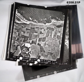
Photograph - Aerial Photography - Mohogany Ship Search Warrnambool Victoria, Victorian Lands Department, 3.1.1981
... Bendigo Military Museum 37 - 39 Pall Mall Bendigo goldfields These Victorian Lands Dept Aerial Photographs were acquired by the Army Survey Regiment to help locate a Mohogany Ship wreck near Warrnambool Victoria as part of a unit Regimental Training Exercise Royal Australian Survey Corps RASvy Fortuna Army Survey Regiment Army Svy Regt ASR Seven Aerial photographic Prints and Film Negatives and positives of the same images. Images are Numbered 3562- 15,16,17,18,19, 29 and 30. Aerial Photography - Mohogany Ship Search Warrnambool Victoria Photograph Aerial Photography - Mohogany Ship Search Warrnambool Victoria Victorian Lands Department ...These Victorian Lands Dept Aerial Photographs were acquired by the Army Survey Regiment to help locate a Mohogany Ship wreck near Warrnambool Victoria as part of a unit Regimental Training ExerciseSeven Aerial photographic Prints and Film Negatives and positives of the same images. Images are Numbered 3562- 15,16,17,18,19, 29 and 30.royal australian survey corps, rasvy, fortuna, army survey regiment, army svy regt, asr -
 Bendigo Military Museum
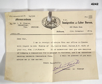
Letter - ADMINISTRATION LETTER, 29.11.1916
... Pierce Sebastion Via Bendigo, 29th November 1916” Letter on official letterhead, yellowed colour, printed in black, ref No 16/581, entries typed in black. At th top is a coat of Arms with “Department of Lands and Survey" around the top. ...The letter from the immigration and Labour Bureau revolves around J.W.Pierce getting his sons wife passage to Australia. The son is also J.W.Pierce No 261 21st Batt AIF who was in France. His wife’s name was Hazel whom he married in late 1916. James returned home in 1919, there is no records in his service documents as to his wife getting passage to Australia. This is George Frederick Pierces brother. George won the DCM. Refer Cat No 4136P for his service details, award and death. Part of the collection of William (Bill) Thomason, refer Cat No 4136P for more items.Letter on official letterhead, yellowed colour, printed in black, ref No 16/581, entries typed in black. At th top is a coat of Arms with “Department of Lands and Survey" around the top.“For Mr J.W. Pierce Sebastion Via Bendigo, 29th November 1916”letters, immigration, military -
 Bendigo Historical Society Inc.
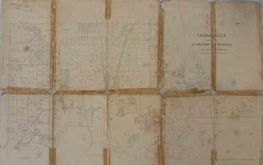
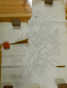
Map - JACK FLYNN MAP COLLECTION: GLADSTONE AND BENDIGO - TARNAGULLA, 13th May 1922
... Bendigo tarnagulla Tarnagulla Kingower Glenalbyn Laanecoorie Inglewood. By Authority A.J. Mullett, Government Printer, Melbourne. Photo-Lithographed at the Department of Lands and Survey, Melbourne by W.J. ...Map 388. Counties of Gladstone and Bendigo a Map of Tarnagulla with Kingower, Glenalbyn, Inglewood, Waanyarra and Laanecoorie boarding. The map is in poor condition and in several pieces. It has been previously taped together. The front page is of red card with white tape along the spine to hold it together, top half Tarnagulla is hand written in black lead on a label with blue trim.By Authority A.J. Mullett, Government Printer, Melbourne. Photo-Lithographed at the Department of Lands and Survey, Melbourne by W.J. Butson. 13.5.22map, bendigo, tarnagulla, tarnagulla, kingower, glenalbyn, laanecoorie, inglewood. -
 Bendigo Historical Society Inc.
Map - VICTORIA, Circa 1926
... History House 11 Mackenzie Street Bendigo goldfields MAP Victoria counties Counties of Victoria Geographic features Map: Map showing Counties, including Railway lines and Geographic features. Compiled and engraved at the Department of Lands and Survey ...Map: Map showing Counties, including Railway lines and Geographic features. Compiled and engraved at the Department of Lands and Survey Melbourne, Revised October 1926 ( number 184 in Map Cupboard 1)map, victoria, counties, counties of victoria, geographic features -
 Bendigo Historical Society Inc.
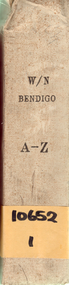
Document - DEPARTMENT OF LANDS AND SURVEY: WIRE NETTING ADVANCE REGISTER BENDIGO REGION
... DEPARTMENT OF LANDS AND SURVEY: WIRE NETTING ADVANCE REGISTER BENDIGO REGION...Department of Lands and Survey Wire Netting Advance register, Bendigo region. ...History House 11 Mackenzie Street Bendigo goldfields ORGANISATION Government Department of Lands and Survey Department of Lands and Survey Wire Netting Advance register, Bendigo region. ...Department of Lands and Survey Wire Netting Advance register, Bendigo region. Large hard cover book with yellow card pages, representing individual properties in the Bendigo area. Written on spine of book: "W/Bendigo, A-Z, 10652,1" Dates in book from 1929 - 1939.organisation, government, department of lands and survey -
 Bendigo Historical Society Inc.
Map - Parish of Strathfieldsaye
... Bendigo canvas backed map. L5169. Includes Axedale, Kimbolton, Eppalock and Sedgewick. Photographed/Lithographed for the Department of Lands and Survey Melbourne by T E McGauran 24.3.07. ...Bendigo canvas backed map. L5169. Includes Axedale, Kimbolton, Eppalock and Sedgewick. Photographed/Lithographed for the Department of Lands and Survey Melbourne by T E McGauran 24.3.07. ...Map owned by Henry Thomas (Jack) Qualtrough who worked for the Victorian Forestry Commission. Shire of Strathfieldsaye County of Bendigo canvas backed map. L5169. Includes Axedale, Kimbolton, Eppalock and Sedgewick. Photographed/Lithographed for the Department of Lands and Survey Melbourne by T E McGauran 24.3.07. Price 1/-.map, axedale, kimbolton, sedgewick, eppalock -
 Bendigo Historical Society Inc.
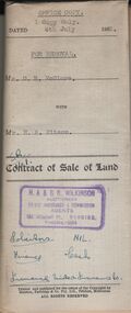
Document - H.A. & S.R. WILKINSON COLLECTION: CONDITION OF SALE
... Also attached various receipt from Department of lands and survey, copy of the right to occupy land issued in 1942, letter from the City of Bendigo dated in 1951 drawing attention to unpaid rates on the property....Bendigo goldfields BHS Collection ORGANIZATION Business h.a. & s.r wilkinson real estate Contract of sale of land dated 4th July, 1952 between Mr. D. R. McClure (seller) and Mr.. H. A. Pitson for land described in right to occupy residence area No. 9508, together with all buildings and erection thereon, also all sundries inside and outside the building. Price 60 pounds. Also attached various receipt from Department of lands and survey ...BHS CollectionContract of sale of land dated 4th July, 1952 between Mr. D. R. McClure (seller) and Mr.. H. A. Pitson for land described in right to occupy residence area No. 9508, together with all buildings and erection thereon, also all sundries inside and outside the building. Price 60 pounds. Also attached various receipt from Department of lands and survey, copy of the right to occupy land issued in 1942, letter from the City of Bendigo dated in 1951 drawing attention to unpaid rates on the property.organization, business, h.a. & s.r wilkinson real estate -
 Bendigo Historical Society Inc.
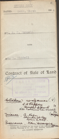
Document - H.A. & S.R. WILKINSON COLLECTION: CONTRACT OF SALE
... Also attached receipt no.81247, dated 13 April, 1954 from the department of Crown Lands and Survey, also a letter to Messrs T.M. Williams , Watson, James, Solicitors, Bull Street Bendigo dated 26 March, 1954 signed by Mr.. ...Bendigo. He was married to Grace Hovendon in 1908. Samuel Ronald "Ron" (1914-1995), Henry's son, was married to Florence Jean McKerlie in 1937. ORGANIZATION Business h.a. & s.r wilkinson real estate Contract of sale of land dated 24th March 1954 between Mr. E.T. Fennell (seller) and Mr. L. Riddell (buyer) for that land situate Jackass Flat being described in right to occupy residence area right No. 0251, together with weatherboard dwelling and all sundry. Price 525 pounds. Also attached receipt no.81247, dated 13 April, 1954 from the department of Crown Lands and Survey ...This business was owned by father and son, Henry Archibald Wilkinson and Samuel Ronald "Ron" Wilkinson. Henry (1882-1954) was born in Shepparton and died in Bendigo. He was married to Grace Hovendon in 1908. Samuel Ronald "Ron" (1914-1995), Henry's son, was married to Florence Jean McKerlie in 1937.Contract of sale of land dated 24th March 1954 between Mr. E.T. Fennell (seller) and Mr. L. Riddell (buyer) for that land situate Jackass Flat being described in right to occupy residence area right No. 0251, together with weatherboard dwelling and all sundry. Price 525 pounds. Also attached receipt no.81247, dated 13 April, 1954 from the department of Crown Lands and Survey, also a letter to Messrs T.M. Williams , Watson, James, Solicitors, Bull Street Bendigo dated 26 March, 1954 signed by Mr.. Fennell instructing to pay from the proceeds of sale of property, Grassy Flat, the sum of 400 pounds to Messrs H.A. & S.R. Wilkinson of 182 Mitchell Street, Bendigo as deposit on purchase of Mr. A.L. Stuckenschmidt's property Raglan Street, White Hills.organization, business, h.a. & s.r wilkinson real estate -
 Bendigo Historical Society Inc.
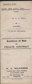
Document - H.A & S.R. WILKINSON COLLECTION: CONTRACT OF SALE
... Bendigo, being the land described in right to occupy residence area No.4501. Also all the vendor's right, title and interest in that piece of land adjoining the above mentioned land described in permissive occupancy title no. W.52845, together with 5-roomed weatherboard dwelling and all sundry. Also bath, copper and troughs. Price 175 pounds. Attached 5 receipt issued by Department of Lands and Survey...Bendigo, being the land described in right to occupy residence area No.4501. Also all the vendor's right, title and interest in that piece of land adjoining the above mentioned land described in permissive occupancy title no. W.52845, together with 5-roomed weatherboard dwelling and all sundry. Also bath, copper and troughs. Price 175 pounds. Attached 5 receipt issued by Department of Lands and Survey ...This business was owned by father and son, Henry Archibald Wilkinson and Samuel Ronald "Ron" Wilkinson. Henry (1882-1954) was born in Shepparton and died in Bendigo. He was married to Grace Hovendon in 1908. Samuel Ronald "Ron" (1914-1995), Henry's son, was married to Florence Jean McKerlie in 1937.Conditions of sale by private sale dated 10th April, 1940 between W.V.O. Earl (seller) and C.M.F. Skilbeck (buyer) for land situate No.148 Booth Street, Bendigo, being the land described in right to occupy residence area No.4501. Also all the vendor's right, title and interest in that piece of land adjoining the above mentioned land described in permissive occupancy title no. W.52845, together with 5-roomed weatherboard dwelling and all sundry. Also bath, copper and troughs. Price 175 pounds. Attached 5 receipt issued by Department of Lands and Survey plus 2 receipt from City of Bendigo for rates. Vendor's copy.organization, business, h.a. & s.r wilkinson real estate -
 Bendigo Historical Society Inc.
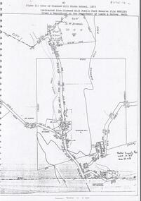
Document - DIAMOND HILL STATE SCHOOL SITE
... History House 11 Mackenzie Street Bendigo goldfields BENDIGO Education diamond hill state school Map (copy) showing the site of Diamond Hill State School, 1873. On top of page 'extracted from Diamond Hill Public Park Reserve File RS8128, drawn and reproduced at the Department of Lands and Survey, Melbourne' Document DIAMOND HILL STATE SCHOOL SITE ...Map (copy) showing the site of Diamond Hill State School, 1873. On top of page 'extracted from Diamond Hill Public Park Reserve File RS8128, drawn and reproduced at the Department of Lands and Survey, Melbourne'bendigo, education, diamond hill state school -
 Bendigo Historical Society Inc.
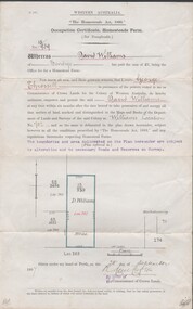
Document - NEVILLE KING COLLECTION: OCCUPATION CERTIFICATE HOMESTEAD FARM NO. 15/939 IN THE NAME OF DAVID WILLIAMS AT A COST OF ONE POUND, DATED 25 SEPTEMBER 1897, 1897
... Bendigo for 160 acres (near Woolkabunning near Bunbury WA); at a cost of one pound. Signed by order of the Commissioner of Crown Lands. Dated 25 September 1897. The land is marked and distinguished in the maps and books of the Department of Lands and Surveys of the said (WA) Colony as Williams Location No. 702....Bendigo for 160 acres (near Woolkabunning near Bunbury WA); at a cost of one pound. Signed by order of the Commissioner of Crown Lands. Dated 25 September 1897. The land is marked and distinguished in the maps and books of the Department of Lands and Surveys of the said (WA) Colony as Williams Location No. 702. ...Under the Western Australia 'the Homestead act 1893' an Occupation Certificate, Homestead Farm No. 15/939 for David Williams of Bendigo for 160 acres (near Woolkabunning near Bunbury WA); at a cost of one pound. Signed by order of the Commissioner of Crown Lands. Dated 25 September 1897. The land is marked and distinguished in the maps and books of the Department of Lands and Surveys of the said (WA) Colony as Williams Location No. 702. -
 Bendigo Historical Society Inc.
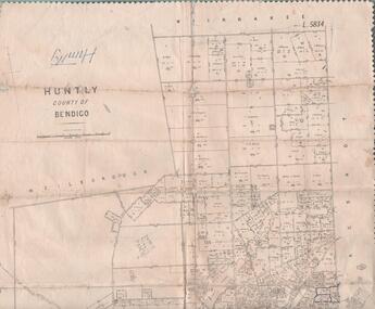
Map - MAP. HUNTLY. COUNTY OF BENDIGO, 1912
... Bendigo. Wellsford. Bagshot. Nerring. Wirrakee. Sandhurst. Photo-lithographed at the Department of lands and Survey. ...Bendigo. Wellsford. Bagshot. Nerring. Wirrakee. Sandhurst. Photo-lithographed at the Department of lands and Survey. ...Map. Huntly. County of Bendigo. Wellsford. Bagshot. Nerring. Wirrakee. Sandhurst. Photo-lithographed at the Department of lands and Survey. Melbourne byW. J. Butson -
 Bendigo Historical Society Inc.
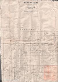
Map - MAP. WARRAGAMBA. COUNTY OF BENDIGO, 1915
... Bendigo. Pannoomilloo. Minto. Diggorra. Kamarooka Photographedat the Department of LANDS AND Survey Melbourne by W. ...Bendigo. Pannoomilloo. Minto. Diggorra. Kamarooka Photographedat the Department of LANDS AND Survey Melbourne by W. ...Map. Warragamba. Colunty of Bendigo. Pannoomilloo. Minto. Diggorra. Kamarooka Photographedat the Department of LANDS AND Survey Melbourne by W. J. Butson. -
 Bendigo Historical Society Inc.
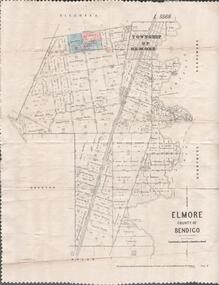
Map - MAP. ELMORE COUNTY OF BENDIGO, 1918
... Bendigo. Diggorra. Burnewang. Ryunnymead. Egerton Photo-Lithographed at the Department of lands and Survey Melbourne, by W. ...Bendigo. Diggorra. Burnewang. Ryunnymead. Egerton Photo-Lithographed at the Department of lands and Survey Melbourne, by W. ...Map. Elmore County of Bendigo. Diggorra. Burnewang. Ryunnymead. Egerton Photo-Lithographed at the Department of lands and Survey Melbourne, by W. J. Button. 4.7.18 -
 Bendigo Historical Society Inc.
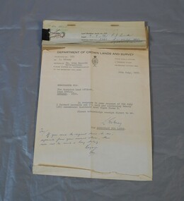
Legal record - Right to occupy a residential area
... Gibney of the department of Crown lands and survey dated 24th July 1972 addressed to the district land officer, Bendigo. ...Bendigo goldfields Land sales right to occupy Government Four books of stubs. Originally the books had 20 right to occupy residence area forms. The stubs record the date of issue, the replacing right No., the fee paid, the receipt no. and a signature. only one of the books has the original form attached, two of the books have handwritten notes attached. One has a typewritten letter from a Mr. L. Gibney of the department of Crown lands and survey ...Four books of stubs. Originally the books had 20 right to occupy residence area forms. The stubs record the date of issue, the replacing right No., the fee paid, the receipt no. and a signature. only one of the books has the original form attached, two of the books have handwritten notes attached. One has a typewritten letter from a Mr. L. Gibney of the department of Crown lands and survey dated 24th July 1972 addressed to the district land officer, Bendigo. In the letter Mr. Gibney tells the officer in Bendigo that a pad containing 20 unnumbered residence area right forms D. The dates on the stubs are 17/04/1961, 16/04/1971, 07/09/1972, 08/05/1975land sales, right to occupy, government -
 Bendigo Historical Society Inc.
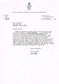
Document - PETER ELLIS COLLECTION: LETTER, 24th September, 1973
... History House 11 Mackenzie Street Bendigo goldfields COMMUNICATION Postal letters Peter Ellis Collection Department of Crown Lands and Survey Victoria Royal Botanic Gardens and National Herbarium P N Ellis Moon Mines Area A B Court Letter, dated 24th September, 1973, to Mr P N Ellis from A B Court of the Royal Botanic Gardens and National Herbarium. ...Letter, dated 24th September, 1973, to Mr P N Ellis from A B Court of the Royal Botanic Gardens and National Herbarium. In the A B Court thanks Mr Ellis for his letter and for the specimen of Acacia hakeoides. He was hoping it would turn out to be the same as the one known to him from the Moon Mines area. He had searched for this species? During the last several years but had been unable to find it. He suggest that if Mr Ellis or his associates find anything of interest in the locality it might be worthwhile forwarding a specimen for examination. Signed A B Court.communication, postal, letters, peter ellis collection, department of crown lands and survey victoria, royal botanic gardens and national herbarium, p n ellis, moon mines area, a b court -
 Bendigo Historical Society Inc.
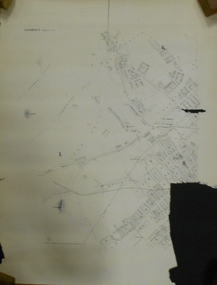
Document - MARKS COLLECTION: PLAN OF SANDHURST CITY CENTRE AND SURROUNDING AREA ( NO. 2 )
... BENDIGO Planning sandhurst Plan drawn on heavy parchment. Written on plan Sandhurst Sheet No. 2. (See record 8300.58 for continuation of plan into city centre) Plan shows allotments with owner names, where applicable. Quartz crushing machines marked. On bottom lithographed at the Department of Lands and Survey ...Plan drawn on heavy parchment. Written on plan Sandhurst Sheet No. 2. (See record 8300.58 for continuation of plan into city centre) Plan shows allotments with owner names, where applicable. Quartz crushing machines marked. On bottom lithographed at the Department of Lands and Survey, Melbourne, by D. Henerson, March 12th., 1867. There is also a photocopy.bendigo, planning, sandhurst -
 Bendigo Historical Society Inc.
Document - MARKS COLLECTION: PLAN OF SANDHURST CITY CENTRE AND SURROUNDING AREA ( NO. 1 )
... BENDIGO Planning sandhurst 1867 Plan on heavy parchment - section neatly cut out of area now Kennington. Written on plan in black print ' Sheet No. 1. Sandhurst'. Plan shows Government Camp, Commissioner's Gully, old cemetery site, manure depot, cattle market, Benevolent Asylum Reserve, railway reserve. Landowners' names on allotments. On bottom lithographed at the Department of Lands and Survey ...Plan on heavy parchment - section neatly cut out of area now Kennington. Written on plan in black print ' Sheet No. 1. Sandhurst'. Plan shows Government Camp, Commissioner's Gully, old cemetery site, manure depot, cattle market, Benevolent Asylum Reserve, railway reserve. Landowners' names on allotments. On bottom lithographed at the Department of Lands and Survey, Melbourne, by D. Henerson, March 12th., 1867 Plan part of George Lansell, Fortuna auction, documents found in wardrobe purchased by Marks family in 1930's.bendigo, planning, sandhurst 1867 -
Bendigo Historical Society Inc.
Map - YALLOOK : COUNTY OF BENDIGO, 1957
... Yallook, County of Bendigo, Talambe, Neilborough, Yarraberb, Salisbury, Pompapiel. Drawn and reproduced at the Department of Lands and Survey, Melbourne,1957. ...Yallook, County of Bendigo, Talambe, Neilborough, Yarraberb, Salisbury, Pompapiel. Drawn and reproduced at the Department of Lands and Survey, Melbourne,1957. ...Map. Yallook, County of Bendigo, Talambe, Neilborough, Yarraberb, Salisbury, Pompapiel. Drawn and reproduced at the Department of Lands and Survey, Melbourne,1957. Distances shown on the plan are derived from original surveys of varying dates and whilst approximately correct do not necessarily conform to modern standards of accuracy. For survey information application should be made to the central plan office, or to the office of titles. Some ink scibbles appear at the right top of this map. Price 2/-. (number 14 in map cupboard 1)By Authority W.M.Houston, Govt.Printer,Melbourne.map, bendigo, yallook -
Bendigo Historical Society Inc.
Map - BENDIGO AND DISTRICT PARISH MAPS, 21-10-26
... Sandhurst, County of Bendigo, City of Bendigo, Strathfieldsaye, Mandurang, Marong, Nerring, Borough of Eaglehawk, Township of Kangaroo Flat, Lockwood, Huntly, Epsom, Wellsford. By Authority H.J. Green, Government Printer, Photo-Lithographed at the Department of Lands and Survey, Melbourne bj W.J Butson 21-10-26,Price 1/-. ...Sandhurst, County of Bendigo, City of Bendigo, Strathfieldsaye, Mandurang, Marong, Nerring, Borough of Eaglehawk, Township of Kangaroo Flat, Lockwood, Huntly, Epsom, Wellsford. By Authority H.J. Green, Government Printer, Photo-Lithographed at the Department of Lands and Survey, Melbourne bj W.J Butson 21-10-26,Price 1/-. ...Map. Sandhurst, County of Bendigo, City of Bendigo, Strathfieldsaye, Mandurang, Marong, Nerring, Borough of Eaglehawk, Township of Kangaroo Flat, Lockwood, Huntly, Epsom, Wellsford. By Authority H.J. Green, Government Printer, Photo-Lithographed at the Department of Lands and Survey, Melbourne bj W.J Butson 21-10-26,Price 1/-. (number 13 in map cupboard 1)By Authority H.J. Green, Govt. Printermap, bendigo, sandhurst -
Bendigo Historical Society Inc.
Map - HAWKESTONE : COUNTY OF BENDIGO, 7-11-15
... Hawkestone, County of Bendigo, County of Talbot, Lyell, Sutton Grange, Redcastle, Elphinstone, Metcalfe, Coliban River, Myrtle Creek. Albert J. Mullett, Government Printer, Melbourne. Photo-Lithographed at the Department of Lands and Survey...Hawkestone, County of Bendigo, County of Talbot, Lyell, Sutton Grange, Redcastle, Elphinstone, Metcalfe, Coliban River, Myrtle Creek. Albert J. Mullett, Government Printer, Melbourne. Photo-Lithographed at the Department of Lands and Survey ...Map. Hawkestone, County of Bendigo, County of Talbot, Lyell, Sutton Grange, Redcastle, Elphinstone, Metcalfe, Coliban River, Myrtle Creek. Albert J. Mullett, Government Printer, Melbourne. Photo-Lithographed at the Department of Lands and Survey, Melbourne by W.J. Butson,7-11-15. Price 1/-. (number 111 in map cupboard 1)Albert J. Mullett, Government Printer, Melbourne.map, bendigo, hawkestone. -
Bendigo Historical Society Inc.
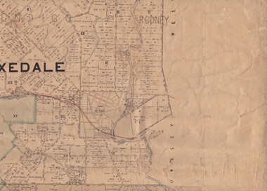
Map - MUSKERRY : COUNTY OF BENDIGO, 1962
... Muskerry, County of Bendigo, County of Rodney, Goornong, Ellesmere, Axedale, Weston, Crosbie, Toolleen, Campaspe, Forest or Mannering Creek, Back Creek, Campaspe River. By authority A.C. Brooks, Government Printer, Melbourne. Drawn and reproduced at the Department of Lands and Survey...Muskerry, County of Bendigo, County of Rodney, Goornong, Ellesmere, Axedale, Weston, Crosbie, Toolleen, Campaspe, Forest or Mannering Creek, Back Creek, Campaspe River. By authority A.C. Brooks, Government Printer, Melbourne. Drawn and reproduced at the Department of Lands and Survey ...Map. Muskerry, County of Bendigo, County of Rodney, Goornong, Ellesmere, Axedale, Weston, Crosbie, Toolleen, Campaspe, Forest or Mannering Creek, Back Creek, Campaspe River. By authority A.C. Brooks, Government Printer, Melbourne. Drawn and reproduced at the Department of Lands and Survey, Melbourne, 1962. Price 2/-. (number 110 in map cupboard 1)A.C. Brooks, Government Printer, Melbourne.map, bendigo, muskerry -
Bendigo Historical Society Inc.
Map - REDCASTLE : COUNTY OF BENDIGO, 10-8-08
... Redcastle, County of Bendigo, County of Rodney, Cornella, Cherrington, Dargile, Crosbie, Cornella Creek, Redcastle Creek, Mount Camel, Township of Redcastle. Photo-Lithographed at the Department. of Lands and Survey, Melbourne by T.F. ...Redcastle, County of Bendigo, County of Rodney, Cornella, Cherrington, Dargile, Crosbie, Cornella Creek, Redcastle Creek, Mount Camel, Township of Redcastle. Photo-Lithographed at the Department. of Lands and Survey, Melbourne by T.F. ...Map. Redcastle, County of Bendigo, County of Rodney, Cornella, Cherrington, Dargile, Crosbie, Cornella Creek, Redcastle Creek, Mount Camel, Township of Redcastle. Photo-Lithographed at the Department. of Lands and Survey, Melbourne by T.F. McGaraun 10-8-08. (number 109 in map cupboard 1)T.F. McGaraunmap, bendigo, redcastle -
Bendigo Historical Society Inc.
Map - WESTON : COUNTY OF BENDIGO : COUNTY OF RODNEY, 4-5-21
... Bendigo, County of Rodney, Muskerry, Crosbie, Knowsley East, Knowsley, Axedale. Back Creek. By authority A.J. Mullett, Government Printer, Melbourne. Photo-Lithographed at the Department of Lands and Survey...Bendigo, County of Rodney, Muskerry, Crosbie, Knowsley East, Knowsley, Axedale. Back Creek. By authority A.J. Mullett, Government Printer, Melbourne. Photo-Lithographed at the Department of Lands and Survey ...Map. Weston, County of Bendigo, County of Rodney, Muskerry, Crosbie, Knowsley East, Knowsley, Axedale. Back Creek. By authority A.J. Mullett, Government Printer, Melbourne. Photo-Lithographed at the Department of Lands and Survey, Melbourne by W.J. Butson 4-5-21. Price 1/-. (number 108 in map cupboard 1)A.J. Mullett, Government Printer, Melbourne.map, bendigo, weston -
Bendigo Historical Society Inc.
Map - RUNNYMEDE : COUNTY OF BENDIGO, 8-12-13
... County of Bendigo, County of Rodney, Burnewang, Elmore, Nolan, Campaspe, Colbinabbin, Burramboot, Corop, Township of Runnymede, Campaspe River, Mount Pleasant Creek. Photo-Lithographed at the Department of Lands and Survey...County of Bendigo, County of Rodney, Burnewang, Elmore, Nolan, Campaspe, Colbinabbin, Burramboot, Corop, Township of Runnymede, Campaspe River, Mount Pleasant Creek. Photo-Lithographed at the Department of Lands and Survey ...Map. County of Bendigo, County of Rodney, Burnewang, Elmore, Nolan, Campaspe, Colbinabbin, Burramboot, Corop, Township of Runnymede, Campaspe River, Mount Pleasant Creek. Photo-Lithographed at the Department of Lands and Survey, Melbourne by W.J. Butson.8-12-13. Price 1/-. (number 107 in map cupboard 1)W.J. Butsonmap, bendigo, runnymede -
Bendigo Historical Society Inc.
Map - TOOLLEEN : COUNTY OF BENDIGO, 25-5-26
... Toolleen, County of Bendigo, County of Rodney, Campaspe, Colbinabbin, Cornella, Crosbie, Muskerry, Mount Pleasant Creek, Township of Toolleen. By authority H.J. Green, Govt. Printer. Photo-Lithographed at the Department of Lands and Survey...Toolleen, County of Bendigo, County of Rodney, Campaspe, Colbinabbin, Cornella, Crosbie, Muskerry, Mount Pleasant Creek, Township of Toolleen. By authority H.J. Green, Govt. Printer. Photo-Lithographed at the Department of Lands and Survey ...Map. Toolleen, County of Bendigo, County of Rodney, Campaspe, Colbinabbin, Cornella, Crosbie, Muskerry, Mount Pleasant Creek, Township of Toolleen. By authority H.J. Green, Govt. Printer. Photo-Lithographed at the Department of Lands and Survey, Melbourne by W.J. Butson, 25-5-26. (number 106 in map cupboard 1)H.J. Green, Govt. Printermap, bendigo, toolleen -
Bendigo Historical Society Inc.
Map - TOOLLEEN : COUNTY OF BENDIGO, 25-5-26
... Toolleen, County of Bendigo, County of Rodney, Campaspe, Colbinabbin, Cornella, Crosbie, Muskerry, Mount Pleasant Creek, Township of Toolleen. By authority H.J. Green, Govt. Printer. Photo-Lithographed at the Department of Lands and Survey...Toolleen, County of Bendigo, County of Rodney, Campaspe, Colbinabbin, Cornella, Crosbie, Muskerry, Mount Pleasant Creek, Township of Toolleen. By authority H.J. Green, Govt. Printer. Photo-Lithographed at the Department of Lands and Survey ...Map. Toolleen, County of Bendigo, County of Rodney, Campaspe, Colbinabbin, Cornella, Crosbie, Muskerry, Mount Pleasant Creek, Township of Toolleen. By authority H.J. Green, Govt. Printer. Photo-Lithographed at the Department of Lands and Survey, Melbourne by W.J. Butson, 25-5-26. (number 105 in map cupboard 1)H.J. Green, Govt. Printer.map, bendigo, toolleen -
Bendigo Historical Society Inc.
Map - KNOWSLEY EAST : COUNTY OF BENDIGO, 18-112-77
... Knowsley East, County of Bendigo, County of Rodney, Weston, Knowsley, Crosbie, Dargile, Heathcote, Forest Creek, Shingle Hut Creek, Mt. Camel Estate, Sheep Station Creek, Mount Ida Creek. Photo-graphed at the Department of Lands and Survey...Knowsley East, County of Bendigo, County of Rodney, Weston, Knowsley, Crosbie, Dargile, Heathcote, Forest Creek, Shingle Hut Creek, Mt. Camel Estate, Sheep Station Creek, Mount Ida Creek. Photo-graphed at the Department of Lands and Survey ...Map. Knowsley East, County of Bendigo, County of Rodney, Weston, Knowsley, Crosbie, Dargile, Heathcote, Forest Creek, Shingle Hut Creek, Mt. Camel Estate, Sheep Station Creek, Mount Ida Creek. Photo-graphed at the Department of Lands and Survey, Melbourne by J. Noune 18-12-77, (number 104 in map cupboard 1)J. Nounemap, bendigo, knowsley east -
Bendigo Historical Society Inc.
Map - KNOWSLEY : COUNTY OF BENDIGO, 7-11-1941
... Bendigo Road. Knowsley Station Ground. Shingle Hut Creek, Forest Creek. By authority H.E. Daw, Government Printer, Melbourne. Drawn and reproduced at the Department of Lands and Survey, Melbourne. 7-11-1941. ...Bendigo Road. Knowsley Station Ground. Shingle Hut Creek, Forest Creek. By authority H.E. Daw, Government Printer, Melbourne. Drawn and reproduced at the Department of Lands and Survey, Melbourne. 7-11-1941. ...Map. Knowsley, County of Bendigo, County of Rodney, Weston, Axedale, Eppalock, Knowsley East, Langwornor, Heathcote, Campaspe River, Mt. Ida Creek or Wild Duck Creek, Sandhurst and Heathcote Railway, Kilmore-Heathcote-Bendigo Road. Knowsley Station Ground. Shingle Hut Creek, Forest Creek. By authority H.E. Daw, Government Printer, Melbourne. Drawn and reproduced at the Department of Lands and Survey, Melbourne. 7-11-1941. Price 2/-. (number 103 in map cupboard 1)H.E. Daw, Government Printer, Melbourne.map, bendigo, knowsley -
Bendigo Historical Society Inc.
Map - KNOWSLEY : COUNTY OF BENDIGO, 21-1-19
... Bendigo and Wallan Railway, Mt. Ida Creek. By authority A.J. Mullett, Government Printer, Melbourne. Photo-Lithographed at the Department of Lands and Survey, Melbourne by W.J. ...Bendigo and Wallan Railway, Mt. Ida Creek. By authority A.J. Mullett, Government Printer, Melbourne. Photo-Lithographed at the Department of Lands and Survey, Melbourne by W.J. ...Map. Knowsley, County of Bendigo, County of Rodney, Weston, Crosbie, Knowsley, Dargile, Heathcote, Shingle Hut Creek, Sheep Station Creek, Forest Creek, Bendigo and Wallan Railway, Mt. Ida Creek. By authority A.J. Mullett, Government Printer, Melbourne. Photo-Lithographed at the Department of Lands and Survey, Melbourne by W.J. Butson 21-1-19, Price 1/-. (number 102 in map cupboard 1)A.J. Mullett, Government Printer, Melbourne.map, bendigo, knowsley east