Showing 3 items matching "lava plain"
-
 Truganina Explosives Reserve Preservation Society Inc (TERPS)
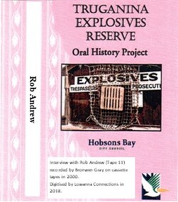
Digitised Oral History – Truganina Explosives Reserve - Tape 11 Rob Andrew, 2018
... ...lava plain...A primary source of information on memories of the Truganina Explosives Reserve and Altona,Victoria Native grasses explosives Cheetham Wetlands Cheetham Salt Works Doug Grant Chirnside Cliff Gibson lava plain brown coal sand ridges Selwyn Fault Rowsley Fault Victorian Coastal Strategy aboriginal stone artefacts aboriginal habitation aboriginal remains red gums casuarinas Altona Skipper Butterfly Orange Bellied Parrot Digital copy of original cassette recorded in 2000 and digitised in 2018 Digitised Oral History – Truganina Explosives Reserve - Tape 11 Rob Andrew ...The interviews were recorded in 2000 by Bronwen Gray and Alan Young for the production of Unreserved, Stories from Truganina Explosives Reserve, animated stories from past residents, workers and interested people of the Reserve (subject to copyright 2004). Rob Andrew’s career was as an Environmental Health Officer with various councils around Victoria. As an Altona resident he became interested in the Truganina Explosives Reserve when he heard the site was to be sold. He was concerned that because of the prospect of commercial development the community would lose tranquil open parklands. Through his involvement with the Reserve he realised the historical, geomorphic, flora and fauna significance of the site. A primary source of information on memories of the Truganina Explosives Reserve and Altona,VictoriaDigital copy of original cassette recorded in 2000 and digitised in 2018native grasses, explosives, cheetham wetlands, cheetham salt works, doug grant, chirnside, cliff gibson, lava plain, brown coal, sand ridges, selwyn fault, rowsley fault, victorian coastal strategy, aboriginal stone artefacts, aboriginal habitation, aboriginal remains, red gums, casuarinas, altona skipper butterfly, orange bellied parrot -
 Federation University Historical Collection
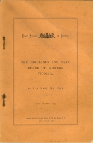
Booklet, Thomas Stephen Hart, The Highlands and Main Divide of Western Victoria, 1907, 12/12/1907
... Hart was a teacher at the Ballarat School of Mines, and a member of the Ballarat Field Naturalists Club thomas hart thomas s. hart ballarat school of mines ballarat field naturalists club royal society of victoria western victoria ballarat great dividing range mt william volcano volcanic plains waterways lal lal basin yarrowee creek ballarat common lava flow wendouree warrenheip ballarat plateau mt elephant grampians t.s. hart mt buangor mt beckworth mt misery mt bolton lal lal iron ored mt ararat mt wiliam mt cole burrumbeet mt warrenheip daylesford waubra ercildoun gap smythesdale lal lal falls parwan valley burrumbeet creek staffordshire reef pyranees bacchus marsh rowsley fault ben nevis avoca hill landsborough hill mt blowhard weatherboard mclean's hill Fyan's Creek thomas stephen hart lal lal Article with illustrations published by the Royal Society of Victoria by Thomas S. ...Thomas S. Hart was a teacher at the Ballarat School of Mines, and a member of the Ballarat Field Naturalists ClubArticle with illustrations published by the Royal Society of Victoria by Thomas S. Hart. The following plates are included: Fig 1. The Main Divide and some of the transverse ridges Fig 2. Hills on and near the Divide at the Ercildoun and Ascot Gaps Fig. 3. Profile of the Divide at Ascot Gap. Fig. 4. Sketch of the Hills west and north-west from Mt Buninyong - - The divide in Ascot Gap from Mt Blowhard (Serra Range, Mt William, Mt Ararat, Larne Gerin, Ben Major, Mt Cole, Mt Misery, Mt Bolton) Fig. 5. Diagram to illustrate the possible courses of the leads south of the present Divide - Burrumbeet Basin (Smythesdale, Ballarat, Lal Lal , Mt Doran, egerton, Parwan Creet, Rowsley Fault, Eastern Plateau) Fig. 6. Diagramatic cross section of the grampians, south of Hall's Gap. Profile of the Pyranees, from maiden Hill - Diagramatic Section of the Grampians south of Hall's Gap. (Mt Cole, Mt Mitchell, Ben Major, Ben More, Avoca Hill, Hall's Gap.) Fig. 7. Profile of the Pyrenees as seen from Maiden Hill near Waubra.thomas hart, thomas s. hart, ballarat school of mines, ballarat field naturalists club, royal society of victoria, western victoria, ballarat, great dividing range, mt william, volcano, volcanic plains, waterways, lal lal basin, yarrowee creek, ballarat common, lava flow, wendouree, warrenheip, ballarat plateau, mt elephant, grampians, t.s. hart, mt buangor, mt beckworth, mt misery, mt bolton, lal lal iron ored, mt ararat, mt wiliam, mt cole, burrumbeet, mt warrenheip, daylesford, waubra, ercildoun gap, smythesdale, lal lal falls, parwan valley, burrumbeet creek, staffordshire reef, pyranees, bacchus marsh, rowsley fault, ben nevis, avoca hill, landsborough hill, mt blowhard, weatherboard, mclean's hill, fyan's creek, thomas stephen hart, lal lal -
 Merri-bek City Council
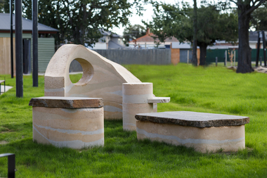
Sculpture - Rammed earth, basalt, mudstone, Isadora Vaughan, Terra Pneumatics, 2021
... The City of Merri-bek and Glenroy lie on the Western Basalt plains of Victoria, with soil and bluestone derived from ancient volcanic lava flows. ...The City of Merri-bek and Glenroy lie on the Western Basalt plains of Victoria, with soil and bluestone derived from ancient volcanic lava flows. ...Located at the Glenroy Community Hub, Isadora Vaughan’s rammed earth and bluestone sculpture draws attention to the continual transformation of Glenroy’s geology and its communities. The City of Merri-bek and Glenroy lie on the Western Basalt plains of Victoria, with soil and bluestone derived from ancient volcanic lava flows. Vaughan’s sculpture is created from these locally found sediments with the range of colours and textures reflecting the changing use of the land as various soils, rocks and sand were introduced from the coastal areas of Victoria. These forms reflect Glenroy’s changing communities, emphasising our relationship with the earth, and have been shaped to enable connection through offering places to sit, lean, play and to gather. Terra Pneumatics embodies the history and sediment of Glenroy —both human and geological — and invites the community to become part of this process of layering and transformation.merri-bek public art collection