Showing 6 items matching "lerderderg state park"
-
 Bacchus Marsh & District Historical Society
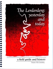
Book, The Lerderderg: Yesterday and Today: A Field Guide and History
... ...Lerderderg State Park...Lerderderg River Lerderderg State Park Lerderderg River History and Environment Lerderderg River First Nations History Lerderderg State Park Gold Mining History Goldmining Bacchus Marsh Region Printed book. ...A natural and cultural history of the Lerderderg River and surrounding wilderness area near Bacchus Marsh. The chapters cover the flora, fauna, geology and geographic features of the Lerderderg River and nearby area. The chapters also include historical sections on gold mining and seeking, irrigation, and the personal recollections of various people with long and deep connections to the area. There is also a section describing the history of Aboriginal peoples connection to the area, the Dja Dja Wurrung and the Wurrundjeri of the Kulin nation.Printed book. Paperback. Spiral bound. 155 pages. Black and white, and colour photographs and illustrations. Subject and name index. Citation: The Lerderderg: Yesterday and Today: A Field Guide and History, Michael Fox, editor. Published for Friends of the Lerderderg, by Pen Folk Publishing, Blackburn, Vic., 2011. BMDHS Location: AR/SU5 lerderderg river, lerderderg state park, lerderderg river history and environment, lerderderg river first nations history, lerderderg state park gold mining history, goldmining bacchus marsh region -
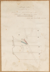
![Map, [Coornmill land area available for leasing for grazing, Parish of Coornmill]. Circa 1904](/media/collectors/5e461d8021ea67224c82f2a1/items/677cde147f2053f3e5d277c3/item-media/677cdeea7f2053f3e5d27bb4/item-fit-380x285.jpg?cb=6) Bacchus Marsh & District Historical Society
Bacchus Marsh & District Historical SocietyMap, [Coornmill land area available for leasing for grazing, Parish of Coornmill]. Circa 1904
... ...Lerderderg State Park Maps...Coornmill Parish Maps Lerderderg State Park Maps Agriculture Bacchus Marsh Area A single page paper map showing an area of land in the Parish of Corrnmill to be made available for grazing leases. ...This map shows an area of land north of Bacchus Marsh in the Larderderg State Park area known as the Parish of Coornmill.The map indicates an area of land which was to be made available by public tender for grazing leaseholders. The plan to do this was discussed in the Bacchus Marsh Express newspaper on the 16 July, 1904, page 2, column 7. The area reserved for grazing leases is identified by red lines on the map. The Express described the area available for grazing was 12,000 acres.A single page paper map showing an area of land in the Parish of Corrnmill to be made available for grazing leases. A photo lithographed Lands Department Map. No scale indicated. The map is pasted into a bound volume containing 76 maps or plans in total. High resolution digital image stored on BMDHS computer network. coornmill parish maps, lerderderg state park maps, agriculture bacchus marsh area -
 Bacchus Marsh & District Historical Society
Map, Rough plan showing proposed deviation of road through McKenzie's Flat
... McKenzie's Flat is a bushland picnic area on the Lerderderg River in the Lerderderg State Park close to Bacchus Marsh. ...McKenzie's Flat is a bushland picnic area on the Lerderderg River in the Lerderderg State Park close to Bacchus Marsh. McKenzies Flat Bacchus Marsh Bacchus Marsh Roads and Streets Single page map showing a proposed deviation of the road near the McKenzie's Flat area close to Bacchus Marsh. ...The date of this map or plan is uncertain. McKenzie's Flat is a bushland picnic area on the Lerderderg River in the Lerderderg State Park close to Bacchus Marsh. Single page map showing a proposed deviation of the road near the McKenzie's Flat area close to Bacchus Marsh. The proposed deviation is shaded in pink, The existing road section to be replaced is shaded in blue. No scale is indicated. Part of a set of maps which are pasted into a bound volume containing 76 maps or plans in total. High resolution digital image stored on BMDHS computer network. mckenzies flat bacchus marsh, bacchus marsh roads and streets -
![Map, Plan showing proposed deviation of the road through McKenzie's Flat to Bacchus Marsh. [Undated]](/media/collectors/5e461d8021ea67224c82f2a1/items/677d22f37f2053f3e5d500dc/item-media/677d25247f2053f3e5d50950/item-fit-380x285.jpg?cb=6) Bacchus Marsh & District Historical Society
Bacchus Marsh & District Historical SocietyMap, Plan showing proposed deviation of the road through McKenzie's Flat to Bacchus Marsh. [Undated]
... McKenzie's Flat is a bushland picnic area on the Lerderderg River in the Lerderderg State Park close to Bacchus Marsh. The proposed road deviation shown on this map is very close to a sharp bend in the Lerderderg River which shows an island in the centre of that bend. ...McKenzie's Flat is a bushland picnic area on the Lerderderg River in the Lerderderg State Park close to Bacchus Marsh. The proposed road deviation shown on this map is very close to a sharp bend in the Lerderderg River which shows an island in the centre of that bend. ...The date of this map or plan is uncertain. McKenzie's Flat is a bushland picnic area on the Lerderderg River in the Lerderderg State Park close to Bacchus Marsh. The proposed road deviation shown on this map is very close to a sharp bend in the Lerderderg River which shows an island in the centre of that bend. The name of a landholder, J.B. Perry is shown on the map close to the area of the road deviation.The land shown is identified as within the Parish of Merrimu.Single page map showing a proposed deviation of the road from McKenzie's Flat to Bacchus Marsh. Scale: 5 chains to 1 inch. Part of a set of maps which are pasted into a bound volume containing 76 maps or plans in total. High resolution digital image stored on BMDHS computer network. mckenzies flat bacchus marsh, bacchus marsh roads and streets -
 Federation University Historical Collection
Booklet, Back to Bacchus Marsh, 1930, 1930
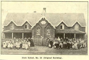
... lerderderg park...coimadai...darely firebrick co....myrniong...balliang...rowsley...parwan...schoosl...churches...shire council...federal milk pty ltd...bacchus marsh milk...old maddingley bridge...police...police paddock...maddingley gates...crisp...mccormack...cain...harkness...howe...bence...mcdonald...mcfarlane...cosgrave...flagg...burnip...scott...lodge...cameron...vallance...bacchus marsh state...Contents include Bacchus Marsh and its soldiers, Red Cross, Lerderderg Gorge, Werribee Gorge, Lerderderg Park, Coimadai, Darely Firebrick Co., Myrniong, Underbank, Balliang, Rowsley, Parwan, schoosl, churches, Shire Council, Federal Milk Pty Ltd, Bacchus Marsh Milk, Old Maddingley Bridge Images include: * Bacchus Marsh looking east, 1930 * Bacchus Marsh Looking West, 1872 * Bacchus Marsh Looking West, 1930 * Aerial View of Bacchus Marsh Township looking east * Aerial View of Bacchus Marsh Township looking south * Bacchus Marsh Agricultural Society & Pastoral Society, 1893 (named), * Original Bacchus Marsh State School No 28 * Holy Trinity Bacchus Marsh * Bacchus Marsh Baptist Church * St Bernard's Catholic Church * Bacchus Marsh Methodist Church * St Andrew's Presbyterian Church Bacchus Marsh * View of Maddingley Park, showing Original Courthouse, 1890 * Werribee Gorge * Underbank Stud Farm * Ballarat State School Number 28. ...(Back to Bacchus Marsh, 1930) bacchus marsh maddingley maddingley park underbank lerderderg park coimadai darely firebrick co. myrniong balliang rowsley parwan schoosl churches shire council federal milk pty ltd bacchus marsh milk old maddingley bridge police police paddock maddingley gates crisp mccormack cain harkness howe bence mcdonald mcfarlane cosgrave flagg burnip scott lodge cameron vallance bacchus marsh state school bacchus marsh state school no 28. geology r.w. thompson lederderg gorge weribee gorge comadai darley firebrick company Signed 'C. ...The 1930 Back to Bacchus Marsh celebrations were held on 23 to 28 October 1930. The committee were Cr L.M. Gugdale (president), A.W. Bond (General secretary), W. Grant Morton, J.G. Wells, Dr E. McDonald, Charles Dickie, G.H. Anderson, F.M. Crisp, W.R. Vigor. Bacchus Marsh State School No. 28 was established in 1851 as a National School in a rented building on the right-hand side of Bacchus Marsh-Melbourne Road, just beyond Woolpack Inn. Several willow trees mark the site. H.G. Ball was the first Head Teacher of the school, and the enrolmen towas 34. In 1854 Governor Charles Hotham visited the school. In 1855 two new schools, East and West, were recommended. School No. 28 closed in 1862 and the sitre was sold. The present school site was purchased in 1865 for 67 pounds. The cost of the building was 782 pounds. (Visions and Realisations, Vol 3., 1973) A clock purchased by public subscription was placed in the front of the building to the memory of scholars who served during World War One. (Back to Bacchus Marsh, 1930)Brown covered book of 44 pages. Contents include Bacchus Marsh and its soldiers, Red Cross, Lerderderg Gorge, Werribee Gorge, Lerderderg Park, Coimadai, Darely Firebrick Co., Myrniong, Underbank, Balliang, Rowsley, Parwan, schoosl, churches, Shire Council, Federal Milk Pty Ltd, Bacchus Marsh Milk, Old Maddingley Bridge Images include: * Bacchus Marsh looking east, 1930 * Bacchus Marsh Looking West, 1872 * Bacchus Marsh Looking West, 1930 * Aerial View of Bacchus Marsh Township looking east * Aerial View of Bacchus Marsh Township looking south * Bacchus Marsh Agricultural Society & Pastoral Society, 1893 (named), * Original Bacchus Marsh State School No 28 * Holy Trinity Bacchus Marsh * Bacchus Marsh Baptist Church * St Bernard's Catholic Church * Bacchus Marsh Methodist Church * St Andrew's Presbyterian Church Bacchus Marsh * View of Maddingley Park, showing Original Courthouse, 1890 * Werribee Gorge * Underbank Stud Farm * Ballarat State School Number 28. Signed 'C. Hodgson'bacchus marsh, maddingley, maddingley park, underbank, lerderderg park, coimadai, darely firebrick co., myrniong, balliang, rowsley, parwan, schoosl, churches, shire council, federal milk pty ltd, bacchus marsh milk, old maddingley bridge, police, police paddock, maddingley gates, crisp, mccormack, cain, harkness, howe, bence, mcdonald, mcfarlane, cosgrave, flagg, burnip, scott, lodge, cameron, vallance, bacchus marsh state school, bacchus marsh state school no 28., geology, r.w. thompson, lederderg gorge, weribee gorge, comadai, darley firebrick company -
 Bacchus Marsh & District Historical Society
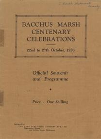
Book, Bacchus Marsh centenary celebrations, 22nd to 27th October, 1936: Official souvenir and programme, 1936
... Lerderderg Library Main Street Bacchus Marsh Bacchus Marsh History Centenaries Bacchus Marsh A souvenir booklet produced in Bacchus Marsh to commemorate 100 years since the arrival of European colonists in the district Bacchus Marsh in 1836. It contains a brief history of European settlement in the area and a description of some of the major industries and infrastructure of the region. Also included are several black and white images of significant local buildings, parks, geographic features and a group portrait of shire councilors; Published by The Lady Publishing Company, Melbourne, 1936. Edited by F. C. McC Crisp; Online edition accessible from State ...A souvenir booklet produced in Bacchus Marsh to commemorate 100 years since the arrival of European colonists in the district Bacchus Marsh in 1836. It contains a brief history of European settlement in the area and a description of some of the major industries and infrastructure of the region. Also included are several black and white images of significant local buildings, parks, geographic features and a group portrait of shire councilors; Published by The Lady Publishing Company, Melbourne, 1936. Edited by F. C. McC Crisp; Online edition accessible from State Library of Victoria at: https://find.slv.vic.gov.au/permalink/61SLV_INST/1sev8ar/alma99837471360763628 pages. 25cm. BMDHS Location: AR/SU4non-fictionA souvenir booklet produced in Bacchus Marsh to commemorate 100 years since the arrival of European colonists in the district Bacchus Marsh in 1836. It contains a brief history of European settlement in the area and a description of some of the major industries and infrastructure of the region. Also included are several black and white images of significant local buildings, parks, geographic features and a group portrait of shire councilors; Published by The Lady Publishing Company, Melbourne, 1936. Edited by F. C. McC Crisp; Online edition accessible from State Library of Victoria at: https://find.slv.vic.gov.au/permalink/61SLV_INST/1sev8ar/alma998374713607636bacchus marsh history, centenaries bacchus marsh