
Showing 9 items matching "licences 1856"
-
 Bendigo Historical Society Inc.
Archive - CROWN LAND LICENCES VICTORIA, 1856, 1856
... CROWN LAND LICENCES VICTORIA, 1856......Licences 1856...Crown land Licences 1856 DVD - Crown land licenses Victoria 1856 Archive CROWN LAND LICENCES VICTORIA, 1856 ...DVD - Crown land licenses Victoria 1856crown land, licences 1856 -
 Bendigo Historical Society Inc.
Slide - DIGGERS & MINING. THE GOLD ERA, c1850s
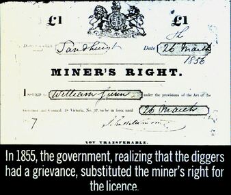
... The Miners Right replaced the Miners Licence in 1856. There was an annual fee of 5/-, giving miners the right to mine, vote and to own land....licence. Slide shows a copy of a Miner's Right 26 March, 1856, William Lunn. ...The Miners Right replaced the Miners Licence in 1856. There was an annual fee of 5/-, giving miners the right to mine, vote and to own land. ...The Miners Right replaced the Miners Licence in 1856. There was an annual fee of 5/-, giving miners the right to mine, vote and to own land.Diggers & mining. The gold era. IN 1855, the government, realizing that the diggers had a grievance, substituted the miner's right for the licence. Slide shows a copy of a Miner's Right 26 March, 1856, William Lunn. Markings 29 994.031 GOL:5. Used as a teaching aid.hanimounteducation, tertiary, goldfields -
 Eltham District Historical Society Inc
Document, Russell Yeoman, Tour of Historic Buildings and Locations, 1978
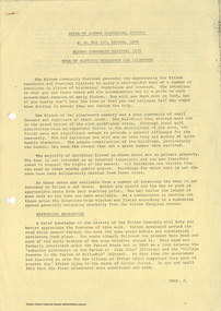
... A licence was first granted for a police station at Eltham in 1856. 21. JARROLD COTTAGE The old Cottage opposite Dalton Street was formerly owned by the Jarrold family. ...A licence was first granted for a police station at Eltham in 1856. 21. JARROLD COTTAGE The old Cottage opposite Dalton Street was formerly owned by the Jarrold family. ...Self guided heritage tour information produced by the Shire of Eltham Historical Society for 1978 Eltham Community Festival of 36 locations each numbered on accompanying map. Locations and detail provided current to 1978: 1. ELTHAM SHOPPING CENTRE Whilst very little remains in the centre of historical importance, this area has interest as the "village" which developed over many years following the opening of the railway from Melbourne in 1902. Previously the shopping centre had been spread out over a long length of Main Road to the south. Shops have been continuously demolished or remodelled and the majority of buildings date from the 1950's or later. The recently erected Post Office replaced the "old" Post Office opened on the same site only in 1958. 2. WOOLWORTHS ELTHAM VILLAGE Part of the site of this modern shopping development was occupied by the former Eltham Shire Offices and Hall. The hall was paid for by public subscription whilst the Council raised a loan for the offices. The combined building was opened in 1941. It served as office and Council meeting place until 1965 and as the hall until its demolition in 1970. 3. ELTHAM WAR MEMORIAL The complex of buildings adjoining the present Shire Offices were financed by public subscription as a Memorial following World War II. Their construction and for many years their operation was organised by the now disbanded Eltham War Memorial Committee. The original buildings were the; Infant Welfare Centre, Children’s Library (now War Memorial Hall and Dental Clinic) and Kindergarten. In later years the Elderly Citizens Club was built at the rear. 4. ELTHAM SHIRE OFFICES These offices were opened in 1965 and extended in 1971 to provide additional office accommodation and the Eltham Library. They represent the last of a long line of offices and meeting places of the Eltham Shire Council and its predecessor the Eltham District Road Board. The building occupies the former site of Shillinglaw Cottage. The three tall cypress trees which stood in front of the Cottage have been retained as a feature of the office surrounds. 5. OUR LADY'S CHURCH AND SCHOOL The Catholic Church and School complex opposite the Shires Offices shows a number of stages in the development of Eltham township. The recently constructed church adjoins its predecessor (now the parish centre). Many years ago the Catholic Church was located opposite Wingrove Park and the present central site follows the northerly drift of the township. 6. SHILLINGLAW COTTAGE The Cottage was built in 1859 by George Stebbing, a local builder who was responsible for a number of other prominent buildings in the area. Its removal from the site of the Shire Offices and re-erection on the present site was financed by public subscription. It is built of handmade bricks laid in Flemish Bond with an unusual design featuring burnt "leader" bricks over the whole facade. The Cottage is occupied by Eltham Fleececrafts and will be open during the Festival and at other times during weekends. It is classified by the National Trust. 7. RAILWAY BRIDGE The timber trestle bridge over the Diamond Creek was built in 1901. Whilst all of its timbers have been replaced at various times over the years the only change to its character has been the addition of pylons and wiring for electric trains in 1923. It is one of very few similar bridges remaining in the metropolitan area. In 1976 a proposal to replace the bridge with an earth embankment and large culvert pipes was abandoned following community protests. The bridge, however, remains under threat because of the necessity for future deuplication of the railway line. 8. ELTHAM CENTPAL PARK The area between the railway and the creek has for many years been used as a park which included Eltham' s main football oval. The access road, Panther Place is named after Eltham's team playing in the Diamond Valley League. In recent years a large area extending to Bridge Street and locally known as the Town Park has been landscaped and added to the area. The excellent blending of the park with the natural landscape of the creek valley has earned a National Trust Landscape Classification. 9. OLD BAKERY On the southern corner of York Street and Main Road is an old house with a shop front which was for many years the local baker's shop. The brick bakery at the rear is of somewhat later vintage than the house. 10. BRIDGE STREET CUTTING Before reconstruction of Main Road this intersection had deep cutting embankments on all four corners, forming a distinctive feature of the entrance to Eltham. Roadworks and private development have levelled the land on the low side of the road. A memorial to the Eltham soldiers of World War I which was located at the north-western corner is now situated at the Eltham R.S.L. 11. HILLTOP MILK BAR For many years this was the site of the Eltham Post Office under the control of the Hunniford family and later their descendants the Burgoynes. It was transferred to this site in 1855, although at that time the building apparently fronted Bridge Str e et. The site contained Eltham's first telephone exchange. The post office was relocated in 1954 but the shop was operated until recently by the Burgoyne family who still own the surrounding land. 12. UNITING CHURCH and former C.B.A. BANK The former Methodist Church was built in 1880 by George Stebbing. The Sunday School extension was built in 1929 and there have been more recent extensions. The adjoining opportunity shop was built as a bank in 1874 and purchased by the Methodist Church in 1954. 13. R.S.L. HALL, TELEPHONE EXCHANGE These relatively recent buildings occupy the site of a row of shops forming part of the early ribbon of business development along Main Road. In front of the R.S.L. building is the World War I Memorial relocated from the corner of Bridge Street and Main Road. 14. ELTHAM COMMUNITY CENTRE Australia's first mudbrick "community building" was opened in April this year. Part of the site of the building was purchased in 1856 by Henry Dendy (of Brighton fame). At the rear of the land near the creek was a steam flour mill whilst Dendy's house was at the Main Road frontage of the land. His purchase totalled about 2 Ha (5 acres) and included land on the opposite side of Maria Street (Main Road). Dendy became a prominent member of the Eltham community and served one term as President of the Eltham District Road Board. In 1867 Dendy sold his land and business to William Ford of Malmsbury and shifted to Walhalla. The avenue of trees leading past the Community Centre to the creek may well have bordered the track to the mill. 15. ELTHAM HOTEL The original part of this hotel was built in 1927 following the burning of the former Watson's Eltham Hotel on the same site. The car park on the opposite side of Main Road was also the site of a hotel variously known over the years as; the Fountain of Friendship, the Fountain and the Evelyn Arms. As the Fountain of Friendship it was the first meeting place of the Eltham District Road Board in 1856. 16. ST. MARGARET'S CHURCH, PITT STREET In 1860 Henry Dendy was appointed Chairman of a committee to establish a church of England in Eltham. He donated part of his land in Pitt Street and in 1861 the church was opened. It was built by George Stebbing and remains in a well preserved state today. Th adjoining old vicarage is now named Dendy Hou se. A new mudbrick church hall is under construction on the site. The church and Dendy House are now listed on the Register of Historic Buildings. 17. NO. 86 PITT STREET Cottage built by George Stebbing and believed to be his home for some years in the 1850s. 18. LIVING AND LEARNING CENTRE The house was built in the 1850s with the kitchen at the front being added about 40 years later. By the creek below the house a number of early Eltham industries were located. These included a tannery and a brewery. 19. ELTHAM COURT HOUSE A Court of Petty Sessions was established in Eltham in 1858 and the present building dates from 1860. It is the oldest public building remaining in Eltham. In its early days the building was used as the meeting place and office of the Eltham District Road Board and as an overflow classroom for the local school. The Court House has been classified by the National Trust. The citation states that it is an example of the simple form of early brick Court House with gabled roof and porch. 20. LANDS DEPARTMENT OFFICE This building is the former police station and is probably of about the same age as the Court House. The lockup at the rear has been demolished but the old stables remain as garages. A licence was first granted for a police station at Eltham in 1856. 21. JARROLD COTTAGE The old Cottage opposite Dalton Street was formerly owned by the Jarrold family. Early records indicate that this was the building leased from the Jarrolds as a temporary police station prior to construction of the building on the corner of Brougham Street. The small building on the corner of the property was used as a boot repairer's shop. The elevated studio at the rear is a more recent construction by the present owners. 22. STATE SCHOOL RESIDENCE Erected in 1891 23. WINGROVE COTTAGE This building fills an important place in the history of Eltham and is now used as a medical clinic. It was built in 1858 for Charles S. Wingrove who was Secretary to the Eltham District Road Board and Shire Council from 1858 to 1904. During part of this period he was also Shire Engineer and was Secretary to the Heidelberg Road Board. The house was used as the office of the Board and Council for many years. Wingrove is buried in the cemetery at St. Helena. 24. WINGROVE PARK The parkland opposite Wingrove Cottage has been named after Charles Wingrove. The old Manna Gums are an outstanding feature of the park. 25. ELTHAM FRI.MARY SCHOOL NO. 209 The school first opened in the slab building in 1855 and operated from the present site since 1857. The oldest part of the present school is the stone building erected in 1876. The first school teacher, David Clark remained at the school until 1888. This school is the government township and has always been known as the Eltham School. An earlier school (no.371) known as Little Eltham School operated in Swan Street from 1853 to 1872. 26. "SHOESTRING" This house was built for school teacher David Clark. It has been extensively extended in recent years but the extensions do not detract from the character of the older part of the building. 27. ELTHAM CEMETERY The cemetery contains the graves of many of the district's pioneers . 28. MONTSALVAT This unique complex of buildings was commenced in 1935 by the late Justus Jorgensen and its development has extended over many years. Montsalvat has exerted a significant impact on Eltham The earth and stone construction of many of the buildings has influenced local architecture to a great extent and it has served as a "nerve centre" of the local artistic community. Montsalvat is open to the public for a small charge. 29. MAIN ROAD BRIDGE This location has been the main crossing of Diamond Creek since the earliest days of settlement. The present concrete bridge was erected in 1925 .and was preceded by a number of timber bridges. 30. ELTHAM LOWER PARK This park, being an unusually large flat area for Eltham, was originally the local racecourse. Horse races were held here from 1855 and the area was gazetted as a reserve for a racecourse and recreation reserve in 1857. The park is well known as a venue for school "bird days" and more recently as the site of the Diamond Valley Railway. This miniature railway features scale models of modern and old locomotives and rolling stock and has operated on this site since 1961 . Before that the railway operated at Chelsworth Park, Ivanhoe. 31. FALKINER HOUSE Frederick Falkiner was one of the earliest settlers in the Eltham township area and occupied a substantial leasehold prior to the first land sales. Early records show that Falkiner was the subject of a number of complaints from his neighbours but he has nevertheless been considered a prominent enough citizen to have a street named for him. This house was the home of Evelyn (Ely) Falkiner a member of Frederick's family. 32. WEST HOUSE Behind the large house on the hill is an early house built by the West family. This was relocated from a site near the front of the land by the present owner Mr. Fabbro. 33. FALKINER HOUSE This very old house is believed to have been the home of Frederick and may have been Eltham's first post office. Falkiner was the first post master for a short period. in 1854/55. 34. WITHERS HOUSE This house was the home of famous artist Walter Withers who shifted here from Heidelberg in 1903. 35. ELTHAM HIGH SCHOOL This school celebrated its jubilee this year, having commenced as the Eltham Higher Elementary School 50 years ago. 36. DIAMOND CREEK FOOTWAY If returning from the High School to the town centre the footpath by the bank of the Diamond Creek provides a pleasant route to finish your walk. The creek is a major tributary of the Yarra River. Together with its own major tributaries Arthurs Creek and Running Creek it commences on the southern slopes of the Dividing Range at Kinglake. It gives the name Diamond Valley to an area extending well beyond its actual drainage catchment.Recognition of the significance of various landmarks to the history of the Eltham community as of 1978‘shoestring’, 1978, bridge street cutting, burgoyne store, c.b.a. bank, diamond creek trail, eltham cemetery, eltham central park, eltham community centre, eltham community festival, eltham court house, eltham festival, eltham high school, eltham hotel, eltham lower park, eltham primary school, eltham railway trestle bridge, eltham shire offices, eltham shopping centre, eltham state school no. 209, eltham village, eltham war memorial, falkiner house, heritage trail, hilltop milk bar, jarrold cottage, lands department office, living, living and learning centre, main road bridge, montsalvat, old bakery, our eltham artistic recollections, our lady help of christian’s church, our lady help of christian’s primary school, pitt street, post office, r.s.l. hall, shillinglaw cottage, st margaret’s church, state school residence, stebbing cottage, telephone exchange, uniting church, west house, wingrove cottage, wingrove park, withers house, woolworths -
 Bendigo Historical Society Inc.
Slide - DIGGERS & MINING. THE GOLD LICENCE, c1856
... licence. The Government Camp. From the original in the Mitchell Library. The Government Camp, Beechworth, 1856. ...licence. The Government Camp. From the original in the Mitchell Library. The Government Camp, Beechworth, 1856. ...Diggers & Mining. The gold licence. The Government Camp. From the original in the Mitchell Library. The Government Camp, Beechworth, 1856. Markings: 46 994.LIF. 4. Used as a teaching aid.hanimounteducation, tertiary, goldfields -
 Bendigo Historical Society Inc.
Slide - DIGGERS & MINING. THE GOLD LICENCE, 26 Mar 1856
... licence. The Government Camp. Shows a copy of the 1 pound Miner's Right, issued in Sandhurst on 26 March 1856, issued to William Lunn, John Williamson and signed 26 March 1857. ...licence. The Government Camp. Shows a copy of the 1 pound Miner's Right, issued in Sandhurst on 26 March 1856, issued to William Lunn, John Williamson and signed 26 March 1857. ...Diggers & Mining. The gold licence. The Government Camp. Shows a copy of the 1 pound Miner's Right, issued in Sandhurst on 26 March 1856, issued to William Lunn, John Williamson and signed 26 March 1857. No attempt was made to police the diggings in order to apprehend diggers working without a current miner's right. (Note the discrepancy in the years) Markings: 42 994.LIF. 4. Used as a teaching aid.hanimounteducation, tertiary, goldfields -
 Bendigo Historical Society Inc.
Photograph - SAILOR'S GULLY HOTEL, 1970s
... Two photographs of the form Sailor's Gully Hotel. The Licence for the hotel in 1856 was a person with the surname of Abernathy. 3874A Façade of Sailor's Gully Hotel, converted to Sailor's Gully Galleries. 3874B Interior of Sailor's Gully Galleries (formerly Sailor's Gully Hotel)....Sailor's Gully hotel gallery Two photographs of the form Sailor's Gully Hotel. The Licence for the hotel in 1856 was a person with the surname of Abernathy. 3874A Façade of Sailor's Gully Hotel, converted to Sailor's Gully Galleries. 3874B Interior of Sailor's Gully Galleries (formerly Sailor's Gully Hotel). ...Two photographs of the form Sailor's Gully Hotel. The Licence for the hotel in 1856 was a person with the surname of Abernathy. 3874A Façade of Sailor's Gully Hotel, converted to Sailor's Gully Galleries. 3874B Interior of Sailor's Gully Galleries (formerly Sailor's Gully Hotel).sailor's gully, hotel, gallery -
 Bendigo Historical Society Inc.
Photograph - BRITISH QUEEN HOTEL: BENDIGO, late 1800's
... 1856. Squire and Mary had married in 1838, "The British Queen" was taken over by John Crowe (1825-1882) some time after 1876. John had previously been the licesee of the Globe Hotel, also in Bridge Street. When John died in 1881, his son Robert Phillip Crowe (Phillip) transferred the licence...1856. Squire and Mary had married in 1838, "The British Queen" was taken over by John Crowe (1825-1882) some time after 1876. John had previously been the licesee of the Globe Hotel, also in Bridge Street. When John died in 1881, his son Robert Phillip Crowe (Phillip) transferred the licence ...The "British Queen Hotel", in Bridge street, Bendigo was first licensed to Squire Barlow (1817-1882), a Lancashire man who came to Australia in 1853 with his two eldest sons, travelling on the "Goldfinder". His wife Mary (nee Taylor, 1814-1891) soon followed with the rest of their children. One more child was born in Sandhurst in 1856. Squire and Mary had married in 1838, "The British Queen" was taken over by John Crowe (1825-1882) some time after 1876. John had previously been the licesee of the Globe Hotel, also in Bridge Street. When John died in 1881, his son Robert Phillip Crowe (Phillip) transferred the licence to John Hope in 1882.Black and white photograph. Buiilding Crowe's British Queen Hotel, 4 people, 2 boys at left, man with hat at centre, lady with long dress centre right. Large hotel light above door, laneway beside building at left with creeper above. On windows of building ' Crowe's British Queen Hotel' On parapet, partially visible ' British Queen..'cottage, miners -
 Bendigo Historical Society Inc.
Document - NARRATIVE OF PATRICK COSTELLO ''IN THE DAYS WHEN THE WORLD WAS WIDE''
... Narrative of Patrick Costello (1841-1856) ''In the days when the world was wide'' Part XIII - Aborigines - Gold Fever! - Bendigo - Gold Licences! ...Licences. Gold Fever. Old White Hill. Narrative of Patrick Costello (1841-1856) ''In the days when the world was wide'' Part XIII - Aborigines - Gold Fever! ...Narrative of Patrick Costello (1841-1856) ''In the days when the world was wide'' Part XIII - Aborigines - Gold Fever! - Bendigo - Gold Licences! Mention of the ''Old White Hill''. ''Piccaninny Gully''. ''Bendigo Mack'' (sic), ''Red Jacket Gully'', Blue Jacket Gully ''.bendigo, history, gold rush, patrick costello. gold licences. gold fever. old white hill. -
 Bendigo Historical Society Inc.
Ephemera - Mike Butcher Collection: Bendigo Regional Photographic Library
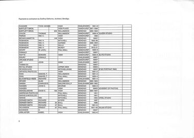
... 1856. Such was the influence of the former that many of their mining practicises were respected and adopted. By the 1871 Victorian census, approximately 15,000 residents of the central goldfields were Cornish. In 1853, a large protest called the Red Ribbon Rebellion was held over the cost of the licence...1856. Such was the influence of the former that many of their mining practicises were respected and adopted. By the 1871 Victorian census, approximately 15,000 residents of the central goldfields were Cornish. In 1853, a large protest called the Red Ribbon Rebellion was held over the cost of the licence ...Gold was officially discovered in the area in October 1851, just after the other significant goldfields in neighbouring Castlemaine, from where a number of diggers migrated, bringing the total population to 40,000 in less than a year. A number of these diggers were Chinese and their descendants still live in the region. During 1852, under the direction of the Surveyor General of Victoria, Robert Hoddle, William Swan Urquhart was making a general survey of Mount Alexander and the surrounding ranges and the goldfields. He fixed the site of the township as "Sandhurst". On 13 July 1852, Hoddle passed on to Urquhart the request of Lieutenant-Governor La Trobe for a plan of the Mount Alexander gold workings, and his order that he mark out a reserve at the junction of Golden Gully with Bendigo Creek, and the camp on the west side of the creek below the junction. In late August La Trobe wanted him to report urgently on the best reserves for agriculture in the district. By 26 November he had mapped Bendigo Creek and Myers Creek and his survey of the Bendigo Valley and environs marked township reserves at Bullock Creek, Ravenswood and Happy Jack where settlement was already taking place. His plan General Survey of the Bendigo Goldfields showing the proposed reserves for townships. Drawn by W. S. Urquhart, Melbourne, November 1852 recommended sites for national schools, churches, markets and other public purposes reserved from sale. The predominant population of the Victorian goldfields throughout the gold rush era was British (being English, Irish, and Scottish), with the largest non-British population being Chinese. During the early gold rush period, about 4,000 Cornish miners went to Mount Alexander (Castlemaine), and by the late 1850s up to 17% of the mining population in Bendigo were Cornish-alone, with almost a quarter being Chinese in 1856. Such was the influence of the former that many of their mining practicises were respected and adopted. By the 1871 Victorian census, approximately 15,000 residents of the central goldfields were Cornish. In 1853, a large protest called the Red Ribbon Rebellion was held over the cost of the licence fee for prospectors, though it passed peacefully due to good diplomacy by police and miners' leaders. From being a tent city, the boomtown grew rapidly into a major urban centre with grand public buildings. The municipality became a borough in 1863, officially known as Sandhurst until 1891, but always unofficially as Bendigo. During this period, miner Henry Bain was noted in local accounts as a cultural patron who hosted informal gatherings of writers, artists and prospectors, later described as the "Golden Circle." The railway had reached Bendigo by 1862, stimulating rapid growth, with flour mills, woollen mills, tanneries, quarries, foundries, eucalyptus oil production, food production industries and timber cutting. When the alluvial gold ran out, extraction of quartz-based gold continued in deep shafts using industrial systems. During this period of growth and development, photographers were recording the growth of the town and those that lived in it. Four A4 pages. Typed document. All pages contain charts of at least nine columns with headings of: Rate Year, Rate Number, Ratepayer First Name, Rate Payer Occupation, Owner/Surname, Owner/First Name, Owner/Occupation, Address and Net Annual Value. Single sided. One A4 page. Typed document. Titled 'Payments by contractors by Godfrey Eathorne, Architect, Bendigo. Contains chart of 8 columns, with headings of: Surname, First Name, Number of Street, Street Name, Date, Title of Studio. Last column left blank.friends of the bendigo library, photography, bendigo
